
Maryland Route 707
Encyclopedia
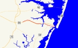
Maryland Route 707 is a collection of state highways
in the .S. state of Maryland
. These three highways are sections of the old alignment of U.S. Route 213 (now US 50
) in northeastern Worcester County
. These stretches of highway were bypassed and designated part of MD 707 in the early 1940s in West Ocean City
and in the late 1940s in Grays Corner.
, adjacent to US 50. The state highway heads east and immediately encounters MD 452
. The state highway continues east as a two-lane road paralleling US 50 on the north at a distance, passing farms and residences. After the intersection with MD 589
(Racetrack Road) in Grays Corner, MD 707B parallels US 50 closely until the end of state maintenance just west of Riddle Lane, which is unsigned US 50WA.
MD 707D begins at a cul-de-sac adjacent to US 50 a short distance east of the eastern terminus of MD 707B. The state highway heads east as a two-lane road paralleling US 50 on the north from a distance and connects with the federal highway via Herring Creek Lane and an unnamed road, which are designated US 50WB and US 50WC, respectively. MD 707D reaches its eastern terminus at a dead end adjacent to US 50 a short distance west of Herring Creek.
.
.
{| class=wikitable
!Mile
!Destinations
!Notes
|-
|0.00
|
|Western terminus of MD 707A
|-
|rowspan=2|0.79
| – Assateague Island National Seashore
|rowspan=2|Eastern terminus of MD 707A; Old Bridge Road to the east was formerly part of MD 707A
|-
|Old Bridge Road east
{| class=wikitable
!Mile
!Destinations
!Notes
|-
|0.00
|Dead end
|Western terminus of MD 707B
|-
|0.07
| – Friendship
|
|-
|1.44
|
|
|-
|2.20
|Grays Corner Road east to Riddle Lane
|Eastern terminus of MD 707B; Grays Corner Road to the east was formerly part of MD 707B; Riddle Lane is unsigned US 50WA
|-
|colspan=3 align=center|Break in highway between MD 707B and MD 707D
|-
|0.00
|Cul-de-sac
|Western terminus of MD 707D
|-
|0.49
|Herring Creek Lane
|Unsigned US 50WB
|-
|0.69
|
|Unsigned US 50WC
|-
|0.76
|Dead end
|Eastern terminus of MD 707D
State highway
State highway, state road or state route can refer to one of three related concepts, two of them related to a state or provincial government in a country that is divided into states or provinces :#A...
in the .S. state of Maryland
Maryland
Maryland is a U.S. state located in the Mid Atlantic region of the United States, bordering Virginia, West Virginia, and the District of Columbia to its south and west; Pennsylvania to its north; and Delaware to its east...
. These three highways are sections of the old alignment of U.S. Route 213 (now US 50
U.S. Route 50 in Maryland
U.S. Route 50 is a major east–west route of the U.S. Highway system, stretching just over from Ocean City, Maryland on the Atlantic Ocean to West Sacramento, California. In the U.S. state of Maryland, US 50 exists in two sections. The longer of these serves as a major route connecting...
) in northeastern Worcester County
Worcester County, Maryland
-2010:Whereas according to the 2010 U.S. Census Bureau:*82.0% White*13.6% Black*0.3% Native American*1.1% Asian*0.0% Native Hawaiian or Pacific Islander*1.7% Two or more races*1.3% Other races*3.2% Hispanic or Latino -2000:...
. These stretches of highway were bypassed and designated part of MD 707 in the early 1940s in West Ocean City
West Ocean City, Maryland
West Ocean City is a census-designated place in Worcester County, Maryland, United States. The population was 3,311 at the 2000 census.-Geography:West Ocean City is located at ....
and in the late 1940s in Grays Corner.
Route description
MD 707A, which is known as Old Bridge Road, runs 0.79 miles (1.3 km) from US 50 to MD 611 within West Ocean City. MD 707B and MD 707D, which are both known as Grays Corner Road, run 2.2 miles (3.5 km) and 0.76 miles (1.2 km), respectively, within Grays Corner.MD 707A
MD 707A begins at an intersection with US 50 (Ocean Gateway) just east of Herring Creek in West Ocean City. The state highway heads east as a two-lane road. After passing by residential subdivisions, MD 707A reaches its eastern terminus at MD 611 (Stephen Decatur Highway). Old Bridge Road continues east as a county highway to Sinepuxent Bay where the old bridge crossed into Ocean City in line with Worcester Street.MD 707B and MD 707D
MD 707B begins at a dead end near BerlinBerlin, Maryland
Berlin is a town in Worcester County, Maryland, United States. The population was 3,491 at the 2000 census.-History:The town of Berlin had its start around the 1790s, part of the Burley Plantation, a land grant dating back to 1677...
, adjacent to US 50. The state highway heads east and immediately encounters MD 452
Maryland Route 452
Maryland Route 452 is a state highway in the U.S. state of Maryland. Known as Friendship Road, the state highway runs from U.S. Route 50 near Berlin north to MD 575 in Friendship, Worcester County...
. The state highway continues east as a two-lane road paralleling US 50 on the north at a distance, passing farms and residences. After the intersection with MD 589
Maryland Route 589
Maryland Route 589 is a state highway in the U.S. state of Maryland. Known as Racetrack Road, the state highway runs from U.S. Route 50 in Grays Corner north to US 113 and MD 575 in Showell. MD 589 provides access to the planned community of Ocean Pines and harness racing venue Ocean Downs,...
(Racetrack Road) in Grays Corner, MD 707B parallels US 50 closely until the end of state maintenance just west of Riddle Lane, which is unsigned US 50WA.
MD 707D begins at a cul-de-sac adjacent to US 50 a short distance east of the eastern terminus of MD 707B. The state highway heads east as a two-lane road paralleling US 50 on the north from a distance and connects with the federal highway via Herring Creek Lane and an unnamed road, which are designated US 50WB and US 50WC, respectively. MD 707D reaches its eastern terminus at a dead end adjacent to US 50 a short distance west of Herring Creek.
History
What is now MD 707 is much of the original alignment of the Berlin–Ocean City road that was paved east to West Ocean City in 1915. The highway was completed when the first automobile bridge across Sinepuxent Bay opened in 1916. The highway was designated the easternmost part of US 213 in 1927. Present day MD 707A was bypassed in 1942 when the present bridge to Ocean City and the dual highway approach west to Herring Creek opened. The bypassed portion of US 213 remained a state highway and was designated MD 707 by 1948. The segment of MD 707 west of Herring Creek was bypassed in 1950 when the dual highway, which had just been renumbered US 50, was extended to just west of MD 452. MD 707A's eastern terminus was rolled back from Sinepuxent Bay to MD 611 in 2001. In 2003, MD 707B was split by construction of an entrance to the Glen Riddle Golf Club subdivision, resulting in the portion east of the split being redesignated MD 707D.Junction list
All three sections of MD 707 are entirely in Worcester CountyWorcester County, Maryland
-2010:Whereas according to the 2010 U.S. Census Bureau:*82.0% White*13.6% Black*0.3% Native American*1.1% Asian*0.0% Native Hawaiian or Pacific Islander*1.7% Two or more races*1.3% Other races*3.2% Hispanic or Latino -2000:...
.
Old Bridge Road
MD 707A is entirely within West Ocean CityWest Ocean City, Maryland
West Ocean City is a census-designated place in Worcester County, Maryland, United States. The population was 3,311 at the 2000 census.-Geography:West Ocean City is located at ....
.
{| class=wikitable
!Mile
!Destinations
!Notes
|-
|0.00
|
|Western terminus of MD 707A
|-
|rowspan=2|0.79
| – Assateague Island National Seashore
Assateague Island National Seashore
Assateague Island National Seashore is a unit of the National Park Service occupying much of Assateague Island along the Atlantic coast of Maryland and Virginia. It is a barrier island shaped by stormy seas and gentle winds. It lies adjacent to Assateague State Park and Chincoteague National...
|rowspan=2|Eastern terminus of MD 707A; Old Bridge Road to the east was formerly part of MD 707A
|-
|Old Bridge Road east
Grays Corner Road
MD 707B and MD 707D are entirely within Grays Corner.{| class=wikitable
!Mile
!Destinations
!Notes
|-
|0.00
|Dead end
|Western terminus of MD 707B
|-
|0.07
| – Friendship
|
|-
|1.44
|
|
|-
|2.20
|Grays Corner Road east to Riddle Lane
|Eastern terminus of MD 707B; Grays Corner Road to the east was formerly part of MD 707B; Riddle Lane is unsigned US 50WA
|-
|colspan=3 align=center|Break in highway between MD 707B and MD 707D
|-
|0.00
|Cul-de-sac
|Western terminus of MD 707D
|-
|0.49
|Herring Creek Lane
|Unsigned US 50WB
|-
|0.69
|
|Unsigned US 50WC
|-
|0.76
|Dead end
|Eastern terminus of MD 707D