
Maryland Route 305
Encyclopedia
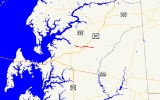
Maryland Route 305 is a state highway
in the U.S. state
of Maryland
. Known as Hope Road, the state highway runs 5.08 miles (8.2 km) from MD 213
in Centreville
east to an intersection with Hayden Road and Dean Road in Hope east of its intersection with U.S. Route 301
(US 301) in central Queen Anne's County
. MD 305 was constructed from a railroad crossing near the present US 301 intersection east to Hope in the early 1910s. The highway was completed when the section between Centreville and the railroad crossing was built in the early 1920s. Another segment of MD 305, unconnected from the present section, existed near Ingleside
from the late 1940s to the mid 1960s.
at grade just east of US 301, then continues east through farmland to the hamlet of Hope, where the state highway ends at an intersection with Dean Road and Hayden Road. Hope Road continues east as a county highway toward MD 405
.
in Ingleside. The Ingleside segment of MD 305 was returned to county maintenance by 1966.
.
{|class=wikitable
!Location
!Mile
!Intersection
!Notes
|-
|Centreville
|0.00
|
|Western terminus
|-
|
|2.92
|, Wilmington
|
|-
|Hope
|5.08
|Dean Road south / Hayden Road north / Hope Road east
|Eastern terminus
State highway
State highway, state road or state route can refer to one of three related concepts, two of them related to a state or provincial government in a country that is divided into states or provinces :#A...
in the U.S. state
U.S. state
A U.S. state is any one of the 50 federated states of the United States of America that share sovereignty with the federal government. Because of this shared sovereignty, an American is a citizen both of the federal entity and of his or her state of domicile. Four states use the official title of...
of Maryland
Maryland
Maryland is a U.S. state located in the Mid Atlantic region of the United States, bordering Virginia, West Virginia, and the District of Columbia to its south and west; Pennsylvania to its north; and Delaware to its east...
. Known as Hope Road, the state highway runs 5.08 miles (8.2 km) from MD 213
Maryland Route 213
Maryland Route 213 is a state highway located on the Eastern Shore of Maryland in the United States. The route runs from Maryland Route 662 in Wye Mills, Queen Anne's County north to the Pennsylvania border in Cecil County, where it continues into that state as Pennsylvania Route 841...
in Centreville
Centreville, Maryland
Centreville is an incorporated town in Queen Anne's County, Maryland, United States. Incorporated in 1794, it is the county seat of Queen Anne's County. The population was 1,970 at the 2000 census. The ZIP code is 21617 and the area code is 410. The local telephone exchange is 758...
east to an intersection with Hayden Road and Dean Road in Hope east of its intersection with U.S. Route 301
U.S. Route 301 in Maryland
U.S. Route 301 in Maryland is a major highway that runs from Delaware to the Governor Harry W. Nice Memorial Bridge into Virginia. It passes through three of Maryland's four main regions: the Eastern Shore, the Baltimore-Washington Metropolitan Area, and Southern Maryland...
(US 301) in central Queen Anne's County
Queen Anne's County, Maryland
Queen Anne's County is a county located on the Eastern Shore of the U.S. state of Maryland.As of 2010, the population was 47,798. Its county seat and most populous municipality is Centreville. The census-designated place of Stevensville is the county's most populous place...
. MD 305 was constructed from a railroad crossing near the present US 301 intersection east to Hope in the early 1910s. The highway was completed when the section between Centreville and the railroad crossing was built in the early 1920s. Another segment of MD 305, unconnected from the present section, existed near Ingleside
Ingleside, Maryland
Ingleside is an unincorporated community in Queen Anne's County, Maryland, United States. Ingleside is located on Maryland Route 19 southeast of Church Hill. Ingleside has a post office with ZIP code 21644....
from the late 1940s to the mid 1960s.
Route description
MD 305 begins at an intersection with MD 213 (Liberty Street) in the northern part of Centreville. The state highway heads east as two-lane Hope Road through a residential area. Upon leaving the town limits, MD 305 passes through farmland. The state highway crosses Three Bridges Branch before intersecting US 301 (Blue Star Memorial Highway) at an acute angle at the hamlet of Carville Station. MD 305 crosses the Centreville Branch of the Northern Line of the Maryland and Delaware RailroadMaryland and Delaware Railroad
The Maryland and Delaware Railroad Company is a Class III short-line railroad, formed in 1977 to operate several branch lines of the former Penn Central Railroad in both Maryland and Delaware. These branches were omitted from the system plan for Conrail in 1976 and would have been discontinued...
at grade just east of US 301, then continues east through farmland to the hamlet of Hope, where the state highway ends at an intersection with Dean Road and Hayden Road. Hope Road continues east as a county highway toward MD 405
Maryland Route 405
Maryland Route 405 is a state highway in the U.S. state of Maryland. Known as Price Station Road, the state highway runs from MD 304 near Bridgetown north to MD 19 near Church Hill. MD 405 connects Church Hill and Bridgetown with the central Queen Anne's County community of Price, where the...
.
History
The first section of MD 305 to be built was from the railroad crossing at Carville Station east to the highway's present eastern terminus at Hope, which was paved as a state aid road by 1915. The highway between Centreville and the railroad crossing was paved in 1923. In 1946, a second, unconnected section of MD 305 was designated on recently-improved Roe Ingleside Road between Carter Road and MD 19Maryland Route 19
Maryland Route 19 is a state highway in the U.S. state of Maryland. Known for much of its length as Roberts Station Road, the state highway runs from MD 213 in Church Hill east to MD 313 in Ingleside. MD 19 runs through central Queen Anne's County, connecting both communities with U.S. Route...
in Ingleside. The Ingleside segment of MD 305 was returned to county maintenance by 1966.
Junction list
The entire route is in Queen Anne's CountyQueen Anne's County, Maryland
Queen Anne's County is a county located on the Eastern Shore of the U.S. state of Maryland.As of 2010, the population was 47,798. Its county seat and most populous municipality is Centreville. The census-designated place of Stevensville is the county's most populous place...
.
{|class=wikitable
!Location
!Mile
!Intersection
!Notes
|-
|Centreville
Centreville, Maryland
Centreville is an incorporated town in Queen Anne's County, Maryland, United States. Incorporated in 1794, it is the county seat of Queen Anne's County. The population was 1,970 at the 2000 census. The ZIP code is 21617 and the area code is 410. The local telephone exchange is 758...
|0.00
|
|Western terminus
|-
|
|2.92
|, Wilmington
Wilmington, Delaware
Wilmington is the largest city in the state of Delaware, United States, and is located at the confluence of the Christina River and Brandywine Creek, near where the Christina flows into the Delaware River. It is the county seat of New Castle County and one of the major cities in the Delaware Valley...
|
|-
|Hope
|5.08
|Dean Road south / Hayden Road north / Hope Road east
|Eastern terminus