
Hurricane Bob
Encyclopedia
Hurricane Bob was one of the costliest hurricanes in New England
history. The second named storm
and first hurricane of the 1991 Atlantic hurricane season
, Bob developed from an area of low pressure near The Bahamas
on August 16. The depression steadily intensified, and became Tropical Storm Bob late on August 16. Bob curved north-northwestward as a tropical storm, but re-curved to the north-northeast after becoming a hurricane on August 17. As such, it brushed the Outer Banks
of North Carolina
on August 18 and August 19, and subsequently intensified into a major hurricane (Category 3 or greater on the Saffir-Simpson Hurricane Scale
). After peaking in intensity with maximum sustained winds of 115 mph (185 km/h), Bob weakened slightly as it approached the coast of New England.
Bob made landfall twice in Rhode Island
as a Category 2 hurricane on August 19, first on Block Island
and then in Newport
. Upon doing so, it became the only hurricane to make landfall
in the contiguous United States during the 1991 season. Moving further inland, Bob rapidly weakened, and deteriorated to a tropical storm while emerging into the Gulf of Maine
. Shortly thereafter, Bob made landfall in Maine
as a strong tropical storm early on August 20. Bob entered the Canadian province of New Brunswick
a few hours later, where it transitioned into an extratropical cyclone
. By August 21, the remnants of Bob crossed Newfoundland and re-emerged into the open Atlantic Ocean. The remnants traveled a long distance across the northern Atlantic Ocean
, and finally dissipated west of Portugal on August 29.
Bob left extensive damage throughout New England in its wake, totaling approximately $1.5 billion (1991 USD
, $ USD). This made it the second costliest United States hurricane at the time; as of 2010, it ranked twenty-second in the category. In addition, seventeen fatalities were reported in association with Bob. The loss of life and most of the damage occurred as a result of high winds and rough seas. There were six confirmed tornadoes during its passage.
trough
to the southeast of Bermuda
on August 12. The system tracked towards the southwest and later west towards the Bahamas. By August 15, satellite analysis of the system found a weak low pressure area
a couple hundred miles east of the Bahamas. Operationally, the system was not declared a tropical depression until 0600 UTC on August 16 after a reconnaissance mission into the storm found a closed circulation and flight level winds of 37 mph (60 km/h). After post-storm analysis, it was determined that the low had developed into a depression around 0000 UTC. Several hours after being designated, the system began to develop convective
banding features
. Roughly 18 hours after being declared a depression, the National Hurricane Center
(NHC) upgraded it to a tropical storm, giving it the name Bob. At this time, Bob was situated roughly 140 mi (225 km) northeast of Nassau, Bahamas
. The storm tracked slowly towards the northwest in response to the deep layer mean flow it was embedded within.
A deepening trough
over the eastern United States was forecast to turn the storm toward the north on August 16. This turn took place earlier than forecasters anticipated. The storm slowly intensified as convection was displaced from the center of circulation
; however, upper-level outflow
was well-defined and intensification of the storm was expected as it tracked over the Gulf Stream
. Later that day, Bob began to consolidate and a reconnaissance plane recorded hurricane-force winds at 1719 UTC, following this reading, the NHC upgraded the storm to a Category 1 hurricane on the Saffir–Simpson Hurricane Scale. Shortly after, the hurricane began to turn towards the north-northeast in response to a subtropical
ridge
over the Atlantic and the trough over the southeastern United States.
By August 18, the NHC noted that the hurricane was asymmetrical, having uneven distribution of the wind radii. Later that day, deep convection continued to form and an eye later appeared on satellite imagery. Early the next day, the eye became increasingly defined as the center of Bob passed roughly 35 mi (55 km) from the North Carolina coastline. By 0600 UTC, Hurricane Hunters
recorded flight level winds of 140 mph (225 km/h), corresponding to surface winds of 115 mph (185 km/h). At this time, the barometric pressure of the storm also decreased to 950 mbar (hPa; 28.05 inHg), the lowest pressure recorded during the storm. After attaining this intensity, the hurricane tracked quickly northeast at 25 mph (35 km/h), steered by the trough over the southeast United States, an upper-level cutoff low over the Great Lakes Region
and the subtropical ridge over the Atlantic.
 The track of Bob by August 19 was similar to that of Hurricane Carol
in 1954
, another major hurricane that impacted New England. Significantly cooler sea surface temperatures in the path of the hurricane resulted in weakening, leading to the eye becoming cloud-filled. Later on August 19, the western portion of the eyewall brushed the eastern tip of Long Island
. Around 1800 UTC, the center of Bob made landfall near Newport, Rhode Island
with winds of 100 mph (155 km/h), making it a Category 2 hurricane. The storm quickly weakened as it tracked through Rhode Island
and Massachusetts
before entering the Gulf of Maine
. Around 0130 UTC on August 20, the now weakened Tropical Storm Bob made another landfall near Rockport, Maine
with winds of 70 mph (110 km/h).
Later that day, Bob had crossed through Maine
and part of New Brunswick
, Canada
and entered the Gulf of St. Lawrence. Around 1800 UTC, the former hurricane transitioned into an extratropical cyclone
. Early the next day, the storm passed over northern Newfoundland before re-entering the Atlantic Ocean. Rapidly tracking eastward, the storm briefly weakened to the equivalent of a tropical depression on August 22. After restrengthening to tropical storm-force winds, the remnants of Bob turned towards the southeast and slowed. Once more, the extratropical system weakened to the equivalent of a tropical depression; however, it did not re-intensify. The storm slowly tracked towards the east before dissipating off the coast of Portugal
on August 29.
for the northwestern Bahamas, between the islands of Andros and Eleuthera. After the storm turned northward, this warning was discontinued as tropical storm-force winds were no longer expected to affect the islands. Shortly before Bob was upgraded to a hurricane on August 17, the NHC issued a hurricane watch
for coastal areas of North Carolina
between Little River Inlet northward to Virginia Beach, Virginia
. Roughly four hours after this watch, it was upgraded to a hurricane warning
. A new hurricane watch was issued late on August 17, encompassing areas between Virginia Beach northward to Cape Henlopen
, Delaware
. This watch was also upgraded to a warning on August 18 as Bob paralleled the Mid-Atlantic coastline. During the afternoon hours, a tropical storm warning was declared for areas in the lower Chesapeake Bay
area, including Norfolk, Virginia
.
A new, extensive hurricane warning was issued late on August 18 as forecasts showed Bob moving directly over southern New England. The warning covered areas between Cape Henlopen, Delaware to Plymouth, Massachusetts, including Long Island
and Long Island Sound
. Early on August 19, all watches and warnings south of Cape Lookout, North Carolina were discontinued and the hurricane warning was extended northward to encompass areas south of Eastport, Maine
. The Canadian Hurricane Centre
began issuing warnings for Atlantic Canada
later that day. Nova Scotia
, Prince Edward Island
and New Brunswick
were placed under wind and heavy rain warnings. By the morning of August 20, all watches and warnings in the United States were discontinued; however, a brief tropical storm warning was declared for coastal Maine between Rockland
and Eastport before the remnants of Bob moved through eastern Canada. The advisories for Atlantic Canada
were later discontinued after the system moved out of the region.
on August 17, mandatory evacuation orders were declared for the outermost islands in the state. Local police assisted significant traffic as an estimated 50,000 to 100,000 people left the region. At the height of the evacuations, delays in some places exceeded three hours. Despite the large number of evacuees, an additional 50,000 people were estimated to have stayed home and wait out the storm. Several bridges in the area were shut down prior to Bob's arrival as hurricane-force winds were likely to create life-threatening conditions on them. The National Park Service
in the state also shut down campgrounds across the Outer Banks
. An evacuation shelter was also opened in Carteret County
.
In Virginia
, 125 planes were relocated from Langley Air Force Base to Wright-Patterson Air Force Base
in Dayton, Ohio
. Roughly 400 people evacuated from coastal areas in Maryland
, and stores in Ocean City
reported a substantial increase in sales related to storm preparation. Further north in New Jersey
, casinos prepared sandbags to protect the structures and tape to cover windows.
In Suffolk County, New York
, emergency officials were unsure of whether or not to issue evacuation orders for residents along coastal areas. This contemplation led to "mixed messages" on the ability of the government being sent to the public. By the evening of August 19, the evacuation order was not issued; however, the county was placed under a state of emergency and disaster centers were opened. The American Red Cross
opened four shelters on Long Island that housed 800 people during the storm.
, officials in Connecticut
and Rhode Island
declared a state of emergency
in anticipation of significant damage. All state workers in the area were told to go home early and prepare for the storm. The Connecticut Legislature
canceled a session on the state's budget and Governor Lowell P. Weicker, Jr.
activated the emergency operations center. Submarines stationed in Groton
left port and waited out the storm under water. Airplane and train service was disrupted throughout the Mid-Atlantic states
and New England in relation to Bob. The American Red Cross opened 23 shelters in 16 communities in Connecticut. In neighboring Rhode Island, the agency set up 40 shelters, and there was an additional 25 shelters unaffiliated with the agency. About 3,500 people statewide evacuated, including 2,000 on Block Island. Several people injured themselves while preparing for the storm.
In Massachusetts
, thousands of residents evacuated Cape Cod
, leading to an 11 mi (17.7 km) backup on the Sagamore Bridge
. There were nine shelters set up in the region, which became overcrowded with evacuees. There were about 50,000 people who left their homes statewide, of which 6,500 went to shelters. On Martha's Vineyard
, electronic stores reported their best business sales in years, with supplies of D-batteries being cleaned off the shelves. Many residents purchased these as well as battery-powered radios and flashlights. President George H. W. Bush
, staying at his home in Kennebunkport, Maine
, evacuated to Pease Air Force Base in New Hampshire
. To avoid possible risks by using helicopter, he drove by motorcade
to the base. During this time, portions of Interstate 95
were closed to allow him direct access to the Air Force base; however, this created many miles of backup as thousands of residents moved inland. Eight shelters were opened in New Hampshire, and about 5,200 people – mostly tourists – evacuated the coastline. There were 49 shelters opened in neighboring Maine, and about 8,600 people evacuated along the coastline in York County
.
In the Bay of Fundy
, fishermen were urged to return to port in fears of large swells from Hurricane Bob.
Throughout the east coast of the United States
, Hurricane Bob produced moderate rainfall and substantial damage. Damage totaled about $1.5 billion (1991 USD). That included about $700 million through cleanup costs, uninsured losses, and food claims. That made it, at the time, the second costliest United States hurricane, although the total was due to the storm passing through a densely-populated region. As of 2010, Hurricane Bob ranked as the 22nd costliest tropical cyclone in the United States mainland. Across its track, the hurricane left 2.1 million people without power. There were six confirmed tornadoes, along with thirteen unconfirmed tornadoes.
, bringing strong winds and heavy rains to the region. Areas along the Atlantic coast in the state recorded up to 5 in (127 mm), with a maximum of 5.3 in (134.6 mm) falling in Cape Hatteras
. One person was killed in the state in relation to Bob, and damage from the storm was estimated at $8 million (1991 USD). The highest sustained winds in the state were recorded at 62 mph (99.8 km/h) in the community of Duck, while the highest gusts reached 74 mph (119.1 km/h) in Cape Hatteras. There was also an unofficial report of a 90 mph (144.8 km/h) gust in Diamond Shoals. A storm surge
between 2.6 to 4.6 ft (0.79248 to 1.4 m) was recorded at Cape Hatteras as well.
Flooding was reported throughout the Outer Banks in relation to the storm's heavy rains and storm surge. The only highway connecting the area to the mainland had to be shut down during the storm, isolating those who decided to stay behind. Many residents lost power as numerous power lines fell from strong winds. Several tornado
es touched down in the state within squall line
s in the outer bands of Hurricane Bob. Six brief tornadoes, ranging between F0 and F1 on the Fujita scale
, were recorded. Four of these touched down in Dare County
, causing $256,000 in damage. One structure was severely damaged by wind in Cape Hatteras, losing its roof and some siding.
Hurricane Bob had little impact in South Carolina
, as the center of the storm remained several hundred miles east of the state. However, large swells
produced by the storm resulted in the drowning of a swimmer in Myrtle Beach
after being caught in strong undertow
. A crew of three sailed from Little River in the state en route to Rhode Island. The hurricane destroyed the mast, leaving the crew stranded over the open ocean in shark-infested waters. After 12 days, the United States Coast Guard
rescued the three.
As the hurricane passed east of Virginia, it produced minimal rainfall and wind gusts of up to 40 mph (65 km/h). There was no reported damage, although there was some minor beach erosion in Sandbridge
. In Ocean City, Maryland
, a brief period of heavy rainfall caused street flooding. High waves left minimal beach erosion and overwash along the coastline. High tides of up to 5.9 ft (1.8 m) occurred along the Delaware coastline. Further north, the hurricane caused widespread beach erosion along the Jersey Shore
, while heavy rains caused street flooding.
The heaviest rains outside of New England fell in Bridgehampton, New York
, where 7.18 in (182.4 mm) fell during the storm's passage. There were two tornadoes on Long Island. High winds destroyed apple, corn, and peach fields along Long Island
. After a dry summer, the sudden deluge wrecked potato crops, resulting in $20 million in crop damage; this accounted for about one-sixth of the region's agricultural output. High winds caused power outages for 477,765 Long Island Lighting Company
customers for a period of nearly five days. Most of the power outages occurred in the East End
. One person died in a car accident while a traffic light was offline, and there was another death when a train conductor was struck by a falling tree. Offshore, the high waves destroyed fish nets, and along the coast caused beach erosion as well as the widespread destruction of boats. Statewide damage totaled over $75 million.
 Before Bob made landfall in New England, it passed directly over Block Island, Rhode Island. Stations on the island recorded gusts to 105 mph (169 km/h) near the upper end of their range, indicating that the winds were likely stronger. On the mainland, winds peaked at 90 mph (144 km/h) in Narragansett
. In the state, the storm surge
—the rise of water above the normal tide—was 6.6 ft (2 m) in the capital city of Providence
, while the peak storm tide—the rise of water including the normal high tide—was 16.5 ft (5 m) at the mouth of the Sakonnet River
. At the latter location, the estimate was based on high water marks, which included wave effects. The high waves resulted in extensive beach erosion along the state's coastline, which washed out several roads in Coventry
. There was flooding reported along the Pocasset River
. Rainfall in the state peaked at 7.13 in (181.1 mm) in North Foster
. In Rhode Island, where the hurricane made landfall, Bob caused about 200,000 power outages; about 60% of residents in the state and southeastern Massachusetts were left without power. During the storm, treatment plants spilled over 100 million tons of sewage due to overflow into Narragansett Bay. Damage totaled over $115 million.
While moving over Rhode Island, the strong winds of Bob extended westward into Connecticut, peaking at 75 mph (120 km/h) near Groton
; there, a gust of 100 mph (160 km/h) was reported. High winds downed trees in every county in the state, although wind damage was heaviest in the southeastern portion near the coast. Overall there were about 315,000 people left without power in Connecticut. A man in Sterling
died after being struck by a falling tree limb. The highest storm surge was 5 ft (1.5 m) in New London
. Coastal flooding was limited to New London County, although coastal damage was minimal. One woman died while on a capsized sailboat. In Norwich
, a rainfall total of 6.22 in (158 mm) was reported, which was the statewide peak. Flooding was minor, limited to streams and small rivers. Total damage in the state was estimated around $49 million, including $4.5 million in crop damage. There was one death due to a fire that occurred during the storm's passage, and there were five other deaths across the state.
The most significant area affected by Bob was Massachusetts, where over $1 billion in damage occurred. A C-MAN
station in Buzzards Bay
recorded winds every hour and observed peak sustained winds of 77 mph (123.9 km/h), along with gusts to 89 mph (143.2 km/h). Sustained winds in the state peaked at 100 mph (161 km/h) in Provincetown
, and there were two unofficial reports of gusts of 125 mph (201.2 km/h). The highest rainfall total in the state was 7.06 in (179.3 mm) in Westfield
. Storm surges in the state were most significant along Buzzards Bay, peaking at 5.8 ft (1.8 m) in New Bedford
and Woods Hole
. High waves eroded the beach around Chatham Light
, leaving behind a 5 ft (1.5 m) cliff. Other locations, including southward-facing shores along Martha's Vineyard
and Nantucket, lost 50 ft (15.2 m) of beach from erosion. Boat damage was significant in the region. The hurricane left over 500,000 people without power, including all of Cape Cod. Damage was heaviest from Buzzards Bay eastward to Cape Cod, and at least 61 houses were destroyed. Damage was also extensive to apple and peach orchard
s across these areas, and agricultural damage was estimated around $10 million. The state also suffered $69 million in damage to public property.
Although it remained offshore of the state, Bob produced strong winds in New Hampshire, with gusts reaching 60 mph (96.6 km/h) at Pease Air National Guard Base
. Mount Washington
experienced 7.46 in (189.5 mm) of precipitation during the storm's passage. Both the Lovell
and Contoocook
rivers experienced flooding due to the storm, and widespread flooding occurred in urban areas in the south and central portions of the state. There were two deaths in the state, one from an automobile accident and the other due to a capsized boat. High winds downed widespread trees and power lines, causing 30,000 people to lose power statewide. Damage was estimated around $2 million. In neighboring Vermont, the highest rainfall report was 4.27 in (108.5 mm) in Vernon
.
Although moving across Maine as a tropical storm, Bob still maintained strong winds, producing gusts to 70 mph (112.7 km/h) in Portland
. A station in Wiscasset reported a gust of 92 mph (148.1 km/h) before it was blown away, and another station recorded a gust of 93 mph (149.7 km/h). A total of 169,200 customers lost power during the hurricane, some of whom remaining without electricity for a week. There was a tornado reported in St. Albans, which downed multiple trees, damaged a few houses, and moved a boathouse three blocks away; its status as a tornado was not confirmed. As it passed the region, the storm produced a 2.77 ft (0.844296 m) storm tide. The heaviest rainfall nationwide from the hurricane fell at the Portland International Jetport
, where 8.24 in (209.3 mm) fell during its passage. This contributed to August 1991 being the wettest month on record in Portland. At the time, its 24 hour rainfall total of 7.83 in (198.9 mm) was the highest on record, although it was surpassed in October 1996 by an extratropical system fueled by Hurricane Lili
. The rains from Bob led to a record flow rate
along the Presumpscot River
, although that record was also surpassed by the 1996 system. River flooding washed out five bridges and roads across southwestern Maine. One man died due to being swept away by floodwaters, and another died in the ocean while on a life raft. A total of 700 houses were affected by the storm, including one that was destroyed and three that sustained major damage. Damage in the area around Portland totaled over $25.7 million, and there were three deaths.
. The highest rainfall amount in the country was 4.37 in (111 mm) in northern New Brunswick. St. John's, Newfoundland and Labrador
recorded a record 1 inch (26 mm) of rainfall during the storm's passage. Gusty winds were observed across the region, and winds reached 68 mph (109 km/h) in Digby, Nova Scotia
. In Nova Scotia
, two 17-year-old girls were washed out to sea near Cape Forchu
after being caught in rough swells produced by the storm. Rescue officials quickly began searching operations; however, it was later confirmed that the two had drowned. In Fredericton, New Brunswick
, tropical storm-force winds downed trees and power lines, resulting in scattered power outages. Lightning
associated with strong storms also reportedly struck some trees in the area. A two-story home in Pointe-Verte
collapsed due to high winds. In Petit-Rocher
, five fishing boats sank after being overwhelmed by large swells at port. Firefighters in the area were surveying the town all night on August 20, checking for downed power lines and trees. Power outages were also reported on Prince Edward Island. The storm left about $1 million in damage (1991 CAD
) on Grand Manan Island in the Bay of Fundy
.
and prevented the algae bloom that happened in previous summers. In the days after Bob, the Commonwealth Electric Company
brought electricians from outside the company and put their own workers on 16 hour shifts to restore power across Massachusetts. Most Massachusetts residents, excluding those living on Cape Cod, had their power restored within five days. The hurricane struck toward the end of the summer, which significantly impacted the tourism season already in the midst of a recession. The New England coast was affected by a powerful nor'easter known as the Perfect Storm about two months after the hurricane struck the region. Some locations experienced worse damage from the October storm than from Bob.
Due to the high damage from the hurricane, president George H.W. Bush declared the following states as disaster (in order): Rhode Island, Massachusetts, Maine, Connecticut, New Hampshire, and New York. Damage in Maine was insufficient to qualify for individual family assistance. Instead, the declaration allocated federal funding to reimburse cities for debris removal, repairing damaged public buildings, and other municipal expenses for each of the states. Despite the declaration, the federal government did not immediately provide aid to the affected region. This was partially due to President Bush considering the storm a "disaster but not an emergency", which therefore required cuts from other budgets to offset the relief aid. This was in opposition to the Democratic-controlled Congress, who requested an expedited process. Because of its impact, the name Bob was retired by the World Meteorological Organization
in the spring of 1992, and will never be used again for an Atlantic hurricane. It was replaced with "Bill" in the 1997 season
.
New England
New England is a region in the northeastern corner of the United States consisting of the six states of Maine, New Hampshire, Vermont, Massachusetts, Rhode Island, and Connecticut...
history. The second named storm
Tropical cyclone naming
Tropical cyclones have officially been named since 1945 and are named for a variety of reasons, which include to facilitate communications between forecasters and the public when forecasts, watches, and warnings are issued. Names also reduce confusion about what storm is being described, as more...
and first hurricane of the 1991 Atlantic hurricane season
1991 Atlantic hurricane season
The 1991 Atlantic hurricane season was the first season in over 24 years in which no hurricanes developed from tropical waves, which are the source for most North Atlantic tropical cyclones. The hurricane season officially began on June 1, and ended on November 30. It was the least...
, Bob developed from an area of low pressure near The Bahamas
The Bahamas
The Bahamas , officially the Commonwealth of the Bahamas, is a nation consisting of 29 islands, 661 cays, and 2,387 islets . It is located in the Atlantic Ocean north of Cuba and Hispaniola , northwest of the Turks and Caicos Islands, and southeast of the United States...
on August 16. The depression steadily intensified, and became Tropical Storm Bob late on August 16. Bob curved north-northwestward as a tropical storm, but re-curved to the north-northeast after becoming a hurricane on August 17. As such, it brushed the Outer Banks
Outer Banks
The Outer Banks is a 200-mile long string of narrow barrier islands off the coast of North Carolina, beginning in the southeastern corner of Virginia Beach on the east coast of the United States....
of North Carolina
North Carolina
North Carolina is a state located in the southeastern United States. The state borders South Carolina and Georgia to the south, Tennessee to the west and Virginia to the north. North Carolina contains 100 counties. Its capital is Raleigh, and its largest city is Charlotte...
on August 18 and August 19, and subsequently intensified into a major hurricane (Category 3 or greater on the Saffir-Simpson Hurricane Scale
Saffir-Simpson Hurricane Scale
The Saffir–Simpson Hurricane Scale , or the Saffir–Simpson Hurricane Wind Scale , classifies hurricanes — Western Hemisphere tropical cyclones that exceed the intensities of tropical depressions and tropical storms — into five categories distinguished by the intensities of their sustained winds...
). After peaking in intensity with maximum sustained winds of 115 mph (185 km/h), Bob weakened slightly as it approached the coast of New England.
Bob made landfall twice in Rhode Island
Rhode Island
The state of Rhode Island and Providence Plantations, more commonly referred to as Rhode Island , is a state in the New England region of the United States. It is the smallest U.S. state by area...
as a Category 2 hurricane on August 19, first on Block Island
Block Island
Block Island is part of the U.S. state of Rhode Island and is located in the Atlantic Ocean approximately south of the coast of Rhode Island, east of Montauk Point on Long Island, and is separated from the Rhode Island mainland by Block Island Sound. The United States Census Bureau defines Block...
and then in Newport
Newport, Rhode Island
Newport is a city on Aquidneck Island in Newport County, Rhode Island, United States, about south of Providence. Known as a New England summer resort and for the famous Newport Mansions, it is the home of Salve Regina University and Naval Station Newport which houses the United States Naval War...
. Upon doing so, it became the only hurricane to make landfall
Landfall (meteorology)
Landfall is the event of a tropical cyclone or a waterspout coming onto land after being over water. When a waterspout makes landfall it is reclassified as a tornado, which can then cause damage inland...
in the contiguous United States during the 1991 season. Moving further inland, Bob rapidly weakened, and deteriorated to a tropical storm while emerging into the Gulf of Maine
Gulf of Maine
The Gulf of Maine is a large gulf of the Atlantic Ocean on the east coast of North America.It is delineated by Cape Cod at the eastern tip of Massachusetts in the southwest and Cape Sable at the southern tip of Nova Scotia in the northeast. It includes the entire coastlines of the U.S...
. Shortly thereafter, Bob made landfall in Maine
Maine
Maine is a state in the New England region of the northeastern United States, bordered by the Atlantic Ocean to the east and south, New Hampshire to the west, and the Canadian provinces of Quebec to the northwest and New Brunswick to the northeast. Maine is both the northernmost and easternmost...
as a strong tropical storm early on August 20. Bob entered the Canadian province of New Brunswick
New Brunswick
New Brunswick is one of Canada's three Maritime provinces and is the only province in the federation that is constitutionally bilingual . The provincial capital is Fredericton and Saint John is the most populous city. Greater Moncton is the largest Census Metropolitan Area...
a few hours later, where it transitioned into an extratropical cyclone
Extratropical cyclone
Extratropical cyclones, sometimes called mid-latitude cyclones or wave cyclones, are a group of cyclones defined as synoptic scale low pressure weather systems that occur in the middle latitudes of the Earth having neither tropical nor polar characteristics, and are connected with fronts and...
. By August 21, the remnants of Bob crossed Newfoundland and re-emerged into the open Atlantic Ocean. The remnants traveled a long distance across the northern Atlantic Ocean
Atlantic Ocean
The Atlantic Ocean is the second-largest of the world's oceanic divisions. With a total area of about , it covers approximately 20% of the Earth's surface and about 26% of its water surface area...
, and finally dissipated west of Portugal on August 29.
Bob left extensive damage throughout New England in its wake, totaling approximately $1.5 billion (1991 USD
United States dollar
The United States dollar , also referred to as the American dollar, is the official currency of the United States of America. It is divided into 100 smaller units called cents or pennies....
, $ USD). This made it the second costliest United States hurricane at the time; as of 2010, it ranked twenty-second in the category. In addition, seventeen fatalities were reported in association with Bob. The loss of life and most of the damage occurred as a result of high winds and rough seas. There were six confirmed tornadoes during its passage.
Meteorological history
Hurricane Bob originated from the remnants of a frontalWeather front
A weather front is a boundary separating two masses of air of different densities, and is the principal cause of meteorological phenomena. In surface weather analyses, fronts are depicted using various colored lines and symbols, depending on the type of front...
trough
Trough (meteorology)
A trough is an elongated region of relatively low atmospheric pressure, often associated with fronts.Unlike fronts, there is not a universal symbol for a trough on a weather chart. The weather charts in some countries or regions mark troughs by a line. In the United States, a trough may be marked...
to the southeast of Bermuda
Bermuda
Bermuda is a British overseas territory in the North Atlantic Ocean. Located off the east coast of the United States, its nearest landmass is Cape Hatteras, North Carolina, about to the west-northwest. It is about south of Halifax, Nova Scotia, Canada, and northeast of Miami, Florida...
on August 12. The system tracked towards the southwest and later west towards the Bahamas. By August 15, satellite analysis of the system found a weak low pressure area
Low pressure area
A low-pressure area, or "low", is a region where the atmospheric pressure at sea level is below that of surrounding locations. Low-pressure systems form under areas of wind divergence which occur in upper levels of the troposphere. The formation process of a low-pressure area is known as...
a couple hundred miles east of the Bahamas. Operationally, the system was not declared a tropical depression until 0600 UTC on August 16 after a reconnaissance mission into the storm found a closed circulation and flight level winds of 37 mph (60 km/h). After post-storm analysis, it was determined that the low had developed into a depression around 0000 UTC. Several hours after being designated, the system began to develop convective
Atmospheric convection
Atmospheric convection is the result of a parcel-environment instability, or temperature difference, layer in the atmosphere. Different lapse rates within dry and moist air lead to instability. Mixing of air during the day which expands the height of the planetary boundary layer leads to...
banding features
Rainband
A rainband is a cloud and precipitation structure associated with an area of rainfall which is significantly elongated. Rainbands can be stratiform or convective, and are generated by differences in temperature. When noted on weather radar imagery, this precipitation elongation is referred to as...
. Roughly 18 hours after being declared a depression, the National Hurricane Center
National Hurricane Center
The National Hurricane Center , located at Florida International University in Miami, Florida, is the division of the National Weather Service responsible for tracking and predicting weather systems within the tropics between the Prime Meridian and the 140th meridian west poleward to the 30th...
(NHC) upgraded it to a tropical storm, giving it the name Bob. At this time, Bob was situated roughly 140 mi (225 km) northeast of Nassau, Bahamas
Nassau, Bahamas
Nassau is the capital, largest city, and commercial centre of the Commonwealth of the Bahamas. The city has a population of 248,948 , 70 percent of the entire population of The Bahamas...
. The storm tracked slowly towards the northwest in response to the deep layer mean flow it was embedded within.
A deepening trough
Trough (meteorology)
A trough is an elongated region of relatively low atmospheric pressure, often associated with fronts.Unlike fronts, there is not a universal symbol for a trough on a weather chart. The weather charts in some countries or regions mark troughs by a line. In the United States, a trough may be marked...
over the eastern United States was forecast to turn the storm toward the north on August 16. This turn took place earlier than forecasters anticipated. The storm slowly intensified as convection was displaced from the center of circulation
Atmospheric circulation
Atmospheric circulation is the large-scale movement of air, and the means by which thermal energy is distributed on the surface of the Earth....
; however, upper-level outflow
Outflow (meteorology)
Outflow, in meteorology, is air that flows outwards from a storm system. It is associated with ridging, or anticyclonic flow. In the low levels of the troposphere, outflow radiates from thunderstorms in the form of a wedge of rain-cooled air, which is visible as a thin rope-like cloud on weather...
was well-defined and intensification of the storm was expected as it tracked over the Gulf Stream
Gulf Stream
The Gulf Stream, together with its northern extension towards Europe, the North Atlantic Drift, is a powerful, warm, and swift Atlantic ocean current that originates at the tip of Florida, and follows the eastern coastlines of the United States and Newfoundland before crossing the Atlantic Ocean...
. Later that day, Bob began to consolidate and a reconnaissance plane recorded hurricane-force winds at 1719 UTC, following this reading, the NHC upgraded the storm to a Category 1 hurricane on the Saffir–Simpson Hurricane Scale. Shortly after, the hurricane began to turn towards the north-northeast in response to a subtropical
Subtropical cyclone
A subtropical cyclone is a weather system that has some characteristics of a tropical and an extratropical cyclone. As early as the 1950s, meteorologists were unclear whether they should be characterized as tropical or extratropical cyclones. They were officially recognized by the National...
ridge
Ridge (meteorology)
A ridge is an elongated region of relatively high atmospheric pressure, the opposite of a trough....
over the Atlantic and the trough over the southeastern United States.
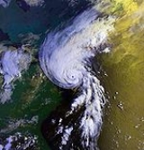
By August 18, the NHC noted that the hurricane was asymmetrical, having uneven distribution of the wind radii. Later that day, deep convection continued to form and an eye later appeared on satellite imagery. Early the next day, the eye became increasingly defined as the center of Bob passed roughly 35 mi (55 km) from the North Carolina coastline. By 0600 UTC, Hurricane Hunters
Hurricane Hunters
The Hurricane Hunters are aircraft that fly into tropical cyclones in the North Atlantic Ocean and Northeastern Pacific Ocean for the specific purpose of directly measuring weather data in and around those storms. In the United States, the Air Force, Navy, and NOAA units have all participated in...
recorded flight level winds of 140 mph (225 km/h), corresponding to surface winds of 115 mph (185 km/h). At this time, the barometric pressure of the storm also decreased to 950 mbar (hPa; 28.05 inHg), the lowest pressure recorded during the storm. After attaining this intensity, the hurricane tracked quickly northeast at 25 mph (35 km/h), steered by the trough over the southeast United States, an upper-level cutoff low over the Great Lakes Region
Great Lakes region (North America)
The Great Lakes region of North America, occasionally known as the Third Coast or the Fresh Coast , includes the eight U.S. states of Illinois, Indiana, Michigan, Minnesota, New York, Ohio, Pennsylvania and Wisconsin as well as the Canadian province of Ontario...
and the subtropical ridge over the Atlantic.
Hurricane Carol
Hurricane Carol was among the worst tropical cyclones to affect the New England region of the United States. It developed from a tropical wave near the Bahamas on August 25, 1954, and gradually strengthened as it moved northwestward. On August 27, Carol intensified to reach winds of , but weakened...
in 1954
1954 Atlantic hurricane season
The 1954 Atlantic hurricane season caused over $750 million in damage, the most of any season at the time. The season officially began on June 15, and nine days later the first named storm developed. Hurricane Alice developed in the Gulf of Mexico and moved inland along the Rio Grande,...
, another major hurricane that impacted New England. Significantly cooler sea surface temperatures in the path of the hurricane resulted in weakening, leading to the eye becoming cloud-filled. Later on August 19, the western portion of the eyewall brushed the eastern tip of Long Island
Long Island
Long Island is an island located in the southeast part of the U.S. state of New York, just east of Manhattan. Stretching northeast into the Atlantic Ocean, Long Island contains four counties, two of which are boroughs of New York City , and two of which are mainly suburban...
. Around 1800 UTC, the center of Bob made landfall near Newport, Rhode Island
Newport, Rhode Island
Newport is a city on Aquidneck Island in Newport County, Rhode Island, United States, about south of Providence. Known as a New England summer resort and for the famous Newport Mansions, it is the home of Salve Regina University and Naval Station Newport which houses the United States Naval War...
with winds of 100 mph (155 km/h), making it a Category 2 hurricane. The storm quickly weakened as it tracked through Rhode Island
Rhode Island
The state of Rhode Island and Providence Plantations, more commonly referred to as Rhode Island , is a state in the New England region of the United States. It is the smallest U.S. state by area...
and Massachusetts
Massachusetts
The Commonwealth of Massachusetts is a state in the New England region of the northeastern United States of America. It is bordered by Rhode Island and Connecticut to the south, New York to the west, and Vermont and New Hampshire to the north; at its east lies the Atlantic Ocean. As of the 2010...
before entering the Gulf of Maine
Gulf of Maine
The Gulf of Maine is a large gulf of the Atlantic Ocean on the east coast of North America.It is delineated by Cape Cod at the eastern tip of Massachusetts in the southwest and Cape Sable at the southern tip of Nova Scotia in the northeast. It includes the entire coastlines of the U.S...
. Around 0130 UTC on August 20, the now weakened Tropical Storm Bob made another landfall near Rockport, Maine
Rockport, Maine
Rockport is a town in Knox County, Maine, United States. The population was 3,209 at the 2000 census. Rockport is a popular tourist destination and art colony.-History:...
with winds of 70 mph (110 km/h).
Later that day, Bob had crossed through Maine
Maine
Maine is a state in the New England region of the northeastern United States, bordered by the Atlantic Ocean to the east and south, New Hampshire to the west, and the Canadian provinces of Quebec to the northwest and New Brunswick to the northeast. Maine is both the northernmost and easternmost...
and part of New Brunswick
New Brunswick
New Brunswick is one of Canada's three Maritime provinces and is the only province in the federation that is constitutionally bilingual . The provincial capital is Fredericton and Saint John is the most populous city. Greater Moncton is the largest Census Metropolitan Area...
, Canada
Canada
Canada is a North American country consisting of ten provinces and three territories. Located in the northern part of the continent, it extends from the Atlantic Ocean in the east to the Pacific Ocean in the west, and northward into the Arctic Ocean...
and entered the Gulf of St. Lawrence. Around 1800 UTC, the former hurricane transitioned into an extratropical cyclone
Extratropical cyclone
Extratropical cyclones, sometimes called mid-latitude cyclones or wave cyclones, are a group of cyclones defined as synoptic scale low pressure weather systems that occur in the middle latitudes of the Earth having neither tropical nor polar characteristics, and are connected with fronts and...
. Early the next day, the storm passed over northern Newfoundland before re-entering the Atlantic Ocean. Rapidly tracking eastward, the storm briefly weakened to the equivalent of a tropical depression on August 22. After restrengthening to tropical storm-force winds, the remnants of Bob turned towards the southeast and slowed. Once more, the extratropical system weakened to the equivalent of a tropical depression; however, it did not re-intensify. The storm slowly tracked towards the east before dissipating off the coast of Portugal
Portugal
Portugal , officially the Portuguese Republic is a country situated in southwestern Europe on the Iberian Peninsula. Portugal is the westernmost country of Europe, and is bordered by the Atlantic Ocean to the West and South and by Spain to the North and East. The Atlantic archipelagos of the...
on August 29.
Preparations
Watches and warnings
Several hours after the declaration of Tropical Storm Bob on August 16, the Government of the Bahamas issued a tropical storm warningTropical cyclone warnings and watches
Warnings and watches are two levels of alert issued by national weather forecasting bodies to coastal areas threatened by the imminent approach of a tropical cyclone of tropical storm or hurricane intensity. They are notices to the local population and civil authorities to make appropriate...
for the northwestern Bahamas, between the islands of Andros and Eleuthera. After the storm turned northward, this warning was discontinued as tropical storm-force winds were no longer expected to affect the islands. Shortly before Bob was upgraded to a hurricane on August 17, the NHC issued a hurricane watch
Tropical cyclone warnings and watches
Warnings and watches are two levels of alert issued by national weather forecasting bodies to coastal areas threatened by the imminent approach of a tropical cyclone of tropical storm or hurricane intensity. They are notices to the local population and civil authorities to make appropriate...
for coastal areas of North Carolina
North Carolina
North Carolina is a state located in the southeastern United States. The state borders South Carolina and Georgia to the south, Tennessee to the west and Virginia to the north. North Carolina contains 100 counties. Its capital is Raleigh, and its largest city is Charlotte...
between Little River Inlet northward to Virginia Beach, Virginia
Virginia Beach, Virginia
Virginia Beach is an independent city located in the Hampton Roads metropolitan area of Virginia, on the Atlantic Ocean at the mouth of the Chesapeake Bay...
. Roughly four hours after this watch, it was upgraded to a hurricane warning
Tropical cyclone warnings and watches
Warnings and watches are two levels of alert issued by national weather forecasting bodies to coastal areas threatened by the imminent approach of a tropical cyclone of tropical storm or hurricane intensity. They are notices to the local population and civil authorities to make appropriate...
. A new hurricane watch was issued late on August 17, encompassing areas between Virginia Beach northward to Cape Henlopen
Cape Henlopen
Cape Henlopen is the southern cape of the Delaware Bay along the Atlantic coast of the United States. It lies in the state of Delaware, near the town of Lewes, Delaware...
, Delaware
Delaware
Delaware is a U.S. state located on the Atlantic Coast in the Mid-Atlantic region of the United States. It is bordered to the south and west by Maryland, and to the north by Pennsylvania...
. This watch was also upgraded to a warning on August 18 as Bob paralleled the Mid-Atlantic coastline. During the afternoon hours, a tropical storm warning was declared for areas in the lower Chesapeake Bay
Chesapeake Bay
The Chesapeake Bay is the largest estuary in the United States. It lies off the Atlantic Ocean, surrounded by Maryland and Virginia. The Chesapeake Bay's drainage basin covers in the District of Columbia and parts of six states: New York, Pennsylvania, Delaware, Maryland, Virginia, and West...
area, including Norfolk, Virginia
Norfolk, Virginia
Norfolk is an independent city in the Commonwealth of Virginia in the United States. With a population of 242,803 as of the 2010 Census, it is Virginia's second-largest city behind neighboring Virginia Beach....
.
A new, extensive hurricane warning was issued late on August 18 as forecasts showed Bob moving directly over southern New England. The warning covered areas between Cape Henlopen, Delaware to Plymouth, Massachusetts, including Long Island
Long Island
Long Island is an island located in the southeast part of the U.S. state of New York, just east of Manhattan. Stretching northeast into the Atlantic Ocean, Long Island contains four counties, two of which are boroughs of New York City , and two of which are mainly suburban...
and Long Island Sound
Long Island Sound
Long Island Sound is an estuary of the Atlantic Ocean, located in the United States between Connecticut to the north and Long Island, New York to the south. The mouth of the Connecticut River at Old Saybrook, Connecticut, empties into the sound. On its western end the sound is bounded by the Bronx...
. Early on August 19, all watches and warnings south of Cape Lookout, North Carolina were discontinued and the hurricane warning was extended northward to encompass areas south of Eastport, Maine
Eastport, Maine
Eastport is a small city in Washington County, Maine, United States. The population was 1,640 at the 2000 census. The principal island is Moose Island, which is connected to the mainland by causeway...
. The Canadian Hurricane Centre
Canadian Hurricane Centre
The Canadian Hurricane Centre is a division of the Meteorological Service of Canada, an agency of Canada's Department of the Environment, which exists to advise Canadians on the threat of tropical cyclones such as hurricanes and tropical storms...
began issuing warnings for Atlantic Canada
Atlantic Canada
Atlantic Canada is the region of Canada comprising the four provinces located on the Atlantic coast, excluding Quebec: the three Maritime provinces – New Brunswick, Prince Edward Island, and Nova Scotia – and Newfoundland and Labrador...
later that day. Nova Scotia
Nova Scotia
Nova Scotia is one of Canada's three Maritime provinces and is the most populous province in Atlantic Canada. The name of the province is Latin for "New Scotland," but "Nova Scotia" is the recognized, English-language name of the province. The provincial capital is Halifax. Nova Scotia is the...
, Prince Edward Island
Prince Edward Island
Prince Edward Island is a Canadian province consisting of an island of the same name, as well as other islands. The maritime province is the smallest in the nation in both land area and population...
and New Brunswick
New Brunswick
New Brunswick is one of Canada's three Maritime provinces and is the only province in the federation that is constitutionally bilingual . The provincial capital is Fredericton and Saint John is the most populous city. Greater Moncton is the largest Census Metropolitan Area...
were placed under wind and heavy rain warnings. By the morning of August 20, all watches and warnings in the United States were discontinued; however, a brief tropical storm warning was declared for coastal Maine between Rockland
Rockland, Maine
Rockland is a city in Knox County, Maine, in the United States. As of the 2010 census, the city population was 7,297. It is the county seat of Knox County. The city is a popular tourist destination...
and Eastport before the remnants of Bob moved through eastern Canada. The advisories for Atlantic Canada
Atlantic Canada
Atlantic Canada is the region of Canada comprising the four provinces located on the Atlantic coast, excluding Quebec: the three Maritime provinces – New Brunswick, Prince Edward Island, and Nova Scotia – and Newfoundland and Labrador...
were later discontinued after the system moved out of the region.
Mid-Atlantic states and the Carolinas
Following the issuance of a hurricane warning in North CarolinaNorth Carolina
North Carolina is a state located in the southeastern United States. The state borders South Carolina and Georgia to the south, Tennessee to the west and Virginia to the north. North Carolina contains 100 counties. Its capital is Raleigh, and its largest city is Charlotte...
on August 17, mandatory evacuation orders were declared for the outermost islands in the state. Local police assisted significant traffic as an estimated 50,000 to 100,000 people left the region. At the height of the evacuations, delays in some places exceeded three hours. Despite the large number of evacuees, an additional 50,000 people were estimated to have stayed home and wait out the storm. Several bridges in the area were shut down prior to Bob's arrival as hurricane-force winds were likely to create life-threatening conditions on them. The National Park Service
National Park Service
The National Park Service is the U.S. federal agency that manages all national parks, many national monuments, and other conservation and historical properties with various title designations...
in the state also shut down campgrounds across the Outer Banks
Outer Banks
The Outer Banks is a 200-mile long string of narrow barrier islands off the coast of North Carolina, beginning in the southeastern corner of Virginia Beach on the east coast of the United States....
. An evacuation shelter was also opened in Carteret County
Carteret County, North Carolina
Carteret County is a county located in the U.S. state of North Carolina. As of 2010, the population was 66,469. Its county seat is Beaufort. Most of the county is part of the Crystal Coast....
.
In Virginia
Virginia
The Commonwealth of Virginia , is a U.S. state on the Atlantic Coast of the Southern United States. Virginia is nicknamed the "Old Dominion" and sometimes the "Mother of Presidents" after the eight U.S. presidents born there...
, 125 planes were relocated from Langley Air Force Base to Wright-Patterson Air Force Base
Wright-Patterson Air Force Base
Wright-Patterson Air Force Base is a United States Air Force base in Greene and Montgomery counties in the state of Ohio. It includes both Wright and Patterson Fields, which were originally Wilbur Wright Field and Fairfield Aviation General Supply Depot. Patterson Field is located approximately...
in Dayton, Ohio
Dayton, Ohio
Dayton is the 6th largest city in the U.S. state of Ohio and the county seat of Montgomery County, the fifth most populous county in the state. The population was 141,527 at the 2010 census. The Dayton Metropolitan Statistical Area had a population of 841,502 in the 2010 census...
. Roughly 400 people evacuated from coastal areas in Maryland
Maryland
Maryland is a U.S. state located in the Mid Atlantic region of the United States, bordering Virginia, West Virginia, and the District of Columbia to its south and west; Pennsylvania to its north; and Delaware to its east...
, and stores in Ocean City
Ocean City, Maryland
Ocean City, sometimes known as OC, or OCMD, is an Atlantic Ocean resort town in Worcester County, Maryland, United States. Ocean City is widely known in the Mid-Atlantic region of the United States and is a frequent destination for vacationers in that area...
reported a substantial increase in sales related to storm preparation. Further north in New Jersey
New Jersey
New Jersey is a state in the Northeastern and Middle Atlantic regions of the United States. , its population was 8,791,894. It is bordered on the north and east by the state of New York, on the southeast and south by the Atlantic Ocean, on the west by Pennsylvania and on the southwest by Delaware...
, casinos prepared sandbags to protect the structures and tape to cover windows.
In Suffolk County, New York
Suffolk County, New York
Suffolk County is a county located in the U.S. state of New York on the eastern portion of Long Island. As of the 2010 census, the population was 1,493,350. It was named for the county of Suffolk in England, from which its earliest settlers came...
, emergency officials were unsure of whether or not to issue evacuation orders for residents along coastal areas. This contemplation led to "mixed messages" on the ability of the government being sent to the public. By the evening of August 19, the evacuation order was not issued; however, the county was placed under a state of emergency and disaster centers were opened. The American Red Cross
American Red Cross
The American Red Cross , also known as the American National Red Cross, is a volunteer-led, humanitarian organization that provides emergency assistance, disaster relief and education inside the United States. It is the designated U.S...
opened four shelters on Long Island that housed 800 people during the storm.
New England and Canada
Prior to Bob's arrival in New EnglandNew England
New England is a region in the northeastern corner of the United States consisting of the six states of Maine, New Hampshire, Vermont, Massachusetts, Rhode Island, and Connecticut...
, officials in Connecticut
Connecticut
Connecticut is a state in the New England region of the northeastern United States. It is bordered by Rhode Island to the east, Massachusetts to the north, and the state of New York to the west and the south .Connecticut is named for the Connecticut River, the major U.S. river that approximately...
and Rhode Island
Rhode Island
The state of Rhode Island and Providence Plantations, more commonly referred to as Rhode Island , is a state in the New England region of the United States. It is the smallest U.S. state by area...
declared a state of emergency
State of emergency
A state of emergency is a governmental declaration that may suspend some normal functions of the executive, legislative and judicial powers, alert citizens to change their normal behaviours, or order government agencies to implement emergency preparedness plans. It can also be used as a rationale...
in anticipation of significant damage. All state workers in the area were told to go home early and prepare for the storm. The Connecticut Legislature
Connecticut General Assembly
The Connecticut General Assembly is the state legislature of the U.S. state of Connecticut. It is a bicameral body composed of the 151-member House of Representatives and the 36-member Senate. It meets in the state capital, Hartford. There are no term limits for either chamber.During...
canceled a session on the state's budget and Governor Lowell P. Weicker, Jr.
Lowell P. Weicker, Jr.
Lowell Palmer Weicker, Jr. is an American politician who served as a U.S. Representative, U.S. Senator, and the 85th Governor of Connecticut, and unsuccessfully sought the Republican nomination for President in 1980...
activated the emergency operations center. Submarines stationed in Groton
Groton, Connecticut
Groton is a town located on the Thames River in New London County, Connecticut, United States. The population was 39,907 at the 2000 census....
left port and waited out the storm under water. Airplane and train service was disrupted throughout the Mid-Atlantic states
Mid-Atlantic States
The Mid-Atlantic states, also called middle Atlantic states or simply the mid Atlantic, form a region of the United States generally located between New England and the South...
and New England in relation to Bob. The American Red Cross opened 23 shelters in 16 communities in Connecticut. In neighboring Rhode Island, the agency set up 40 shelters, and there was an additional 25 shelters unaffiliated with the agency. About 3,500 people statewide evacuated, including 2,000 on Block Island. Several people injured themselves while preparing for the storm.
In Massachusetts
Massachusetts
The Commonwealth of Massachusetts is a state in the New England region of the northeastern United States of America. It is bordered by Rhode Island and Connecticut to the south, New York to the west, and Vermont and New Hampshire to the north; at its east lies the Atlantic Ocean. As of the 2010...
, thousands of residents evacuated Cape Cod
Cape Cod
Cape Cod, often referred to locally as simply the Cape, is a cape in the easternmost portion of the state of Massachusetts, in the Northeastern United States...
, leading to an 11 mi (17.7 km) backup on the Sagamore Bridge
Sagamore Bridge
The Sagamore Bridge in Sagamore, Massachusetts carries U.S. Route 6 across the Cape Cod Canal, connecting Cape Cod with the rest of Massachusetts, USA....
. There were nine shelters set up in the region, which became overcrowded with evacuees. There were about 50,000 people who left their homes statewide, of which 6,500 went to shelters. On Martha's Vineyard
Martha's Vineyard
Martha's Vineyard is an island located south of Cape Cod in Massachusetts, known for being an affluent summer colony....
, electronic stores reported their best business sales in years, with supplies of D-batteries being cleaned off the shelves. Many residents purchased these as well as battery-powered radios and flashlights. President George H. W. Bush
George H. W. Bush
George Herbert Walker Bush is an American politician who served as the 41st President of the United States . He had previously served as the 43rd Vice President of the United States , a congressman, an ambassador, and Director of Central Intelligence.Bush was born in Milton, Massachusetts, to...
, staying at his home in Kennebunkport, Maine
Kennebunkport, Maine
Kennebunkport is a town in York County, Maine, United States. The population was 3,720 at the 2000 census. It is part of the Portland–South Portland–Biddeford metropolitan statistical area....
, evacuated to Pease Air Force Base in New Hampshire
New Hampshire
New Hampshire is a state in the New England region of the northeastern United States of America. The state was named after the southern English county of Hampshire. It is bordered by Massachusetts to the south, Vermont to the west, Maine and the Atlantic Ocean to the east, and the Canadian...
. To avoid possible risks by using helicopter, he drove by motorcade
Motorcade
A motorcade is a procession of vehicles. The term motorcade was coined by Lyle Abbot , and is formed after cavalcade on the false notion that "-cade" was a suffix meaning "procession"...
to the base. During this time, portions of Interstate 95
Interstate 95
Interstate 95 is the main highway on the East Coast of the United States, running parallel to the Atlantic Ocean from Maine to Florida and serving some of the most populated urban areas in the country, including Boston, Providence, New Haven, New York City, Newark, Philadelphia, Baltimore,...
were closed to allow him direct access to the Air Force base; however, this created many miles of backup as thousands of residents moved inland. Eight shelters were opened in New Hampshire, and about 5,200 people – mostly tourists – evacuated the coastline. There were 49 shelters opened in neighboring Maine, and about 8,600 people evacuated along the coastline in York County
York County, Maine
York County is a county located in the U.S. state of Maine. In 2010, the population was 197,131. Its county seat is Alfred.Founded in 1636, it is the oldest county in Maine and one of the oldest in the United States....
.
In the Bay of Fundy
Bay of Fundy
The Bay of Fundy is a bay on the Atlantic coast of North America, on the northeast end of the Gulf of Maine between the Canadian provinces of New Brunswick and Nova Scotia, with a small portion touching the U.S. state of Maine...
, fishermen were urged to return to port in fears of large swells from Hurricane Bob.
Impact
| Location | Deaths | Damage(USD) |
| South Carolina South Carolina South Carolina is a state in the Deep South of the United States that borders Georgia to the south, North Carolina to the north, and the Atlantic Ocean to the east. Originally part of the Province of Carolina, the Province of South Carolina was one of the 13 colonies that declared independence... |
1 | - |
| North Carolina North Carolina North Carolina is a state located in the southeastern United States. The state borders South Carolina and Georgia to the south, Tennessee to the west and Virginia to the north. North Carolina contains 100 counties. Its capital is Raleigh, and its largest city is Charlotte... |
1 | $8 million |
| New York New York New York is a state in the Northeastern region of the United States. It is the nation's third most populous state. New York is bordered by New Jersey and Pennsylvania to the south, and by Connecticut, Massachusetts and Vermont to the east... |
2 | $150 million |
| Connecticut Connecticut Connecticut is a state in the New England region of the northeastern United States. It is bordered by Rhode Island to the east, Massachusetts to the north, and the state of New York to the west and the south .Connecticut is named for the Connecticut River, the major U.S. river that approximately... |
4 (2) | $80 million |
| Massachusetts Massachusetts The Commonwealth of Massachusetts is a state in the New England region of the northeastern United States of America. It is bordered by Rhode Island and Connecticut to the south, New York to the west, and Vermont and New Hampshire to the north; at its east lies the Atlantic Ocean. As of the 2010... |
1 | $1 billion |
| Rhode Island Rhode Island The state of Rhode Island and Providence Plantations, more commonly referred to as Rhode Island , is a state in the New England region of the United States. It is the smallest U.S. state by area... |
0 | $230 million |
| New Hampshire New Hampshire New Hampshire is a state in the New England region of the northeastern United States of America. The state was named after the southern English county of Hampshire. It is bordered by Massachusetts to the south, Vermont to the west, Maine and the Atlantic Ocean to the east, and the Canadian... |
2 | $4 million |
| Maine Maine Maine is a state in the New England region of the northeastern United States, bordered by the Atlantic Ocean to the east and south, New Hampshire to the west, and the Canadian provinces of Quebec to the northwest and New Brunswick to the northeast. Maine is both the northernmost and easternmost... |
3 | $42 million |
| Canada Canada Canada is a North American country consisting of ten provinces and three territories. Located in the northern part of the continent, it extends from the Atlantic Ocean in the east to the Pacific Ocean in the west, and northward into the Arctic Ocean... |
2 | - |
| Total | 15 (2) | $1.4 billion |
Throughout the east coast of the United States
East Coast of the United States
The East Coast of the United States, also known as the Eastern Seaboard, refers to the easternmost coastal states in the United States, which touch the Atlantic Ocean and stretch up to Canada. The term includes the U.S...
, Hurricane Bob produced moderate rainfall and substantial damage. Damage totaled about $1.5 billion (1991 USD). That included about $700 million through cleanup costs, uninsured losses, and food claims. That made it, at the time, the second costliest United States hurricane, although the total was due to the storm passing through a densely-populated region. As of 2010, Hurricane Bob ranked as the 22nd costliest tropical cyclone in the United States mainland. Across its track, the hurricane left 2.1 million people without power. There were six confirmed tornadoes, along with thirteen unconfirmed tornadoes.
Carolinas and Mid-Atlantic
On August 18, Hurricane Bob brushed the coastline of North CarolinaNorth Carolina
North Carolina is a state located in the southeastern United States. The state borders South Carolina and Georgia to the south, Tennessee to the west and Virginia to the north. North Carolina contains 100 counties. Its capital is Raleigh, and its largest city is Charlotte...
, bringing strong winds and heavy rains to the region. Areas along the Atlantic coast in the state recorded up to 5 in (127 mm), with a maximum of 5.3 in (134.6 mm) falling in Cape Hatteras
Cape Hatteras
Cape Hatteras is a cape on the coast of North Carolina. It is the point that protrudes the farthest to the southeast along the northeast-to-southwest line of the Atlantic coast of North America...
. One person was killed in the state in relation to Bob, and damage from the storm was estimated at $8 million (1991 USD). The highest sustained winds in the state were recorded at 62 mph (99.8 km/h) in the community of Duck, while the highest gusts reached 74 mph (119.1 km/h) in Cape Hatteras. There was also an unofficial report of a 90 mph (144.8 km/h) gust in Diamond Shoals. A storm surge
Storm surge
A storm surge is an offshore rise of water associated with a low pressure weather system, typically tropical cyclones and strong extratropical cyclones. Storm surges are caused primarily by high winds pushing on the ocean's surface. The wind causes the water to pile up higher than the ordinary sea...
between 2.6 to 4.6 ft (0.79248 to 1.4 m) was recorded at Cape Hatteras as well.
Flooding was reported throughout the Outer Banks in relation to the storm's heavy rains and storm surge. The only highway connecting the area to the mainland had to be shut down during the storm, isolating those who decided to stay behind. Many residents lost power as numerous power lines fell from strong winds. Several tornado
Tornado
A tornado is a violent, dangerous, rotating column of air that is in contact with both the surface of the earth and a cumulonimbus cloud or, in rare cases, the base of a cumulus cloud. They are often referred to as a twister or a cyclone, although the word cyclone is used in meteorology in a wider...
es touched down in the state within squall line
Squall line
A squall line is a line of severe thunderstorms that can form along or ahead of a cold front. In the early 20th century, the term was used as a synonym for cold front. It contains heavy precipitation, hail, frequent lightning, strong straight-line winds, and possibly tornadoes and waterspouts....
s in the outer bands of Hurricane Bob. Six brief tornadoes, ranging between F0 and F1 on the Fujita scale
Fujita scale
The Fujita scale , or Fujita-Pearson scale, is a scale for rating tornado intensity, based primarily on the damage tornadoes inflict on human-built structures and vegetation...
, were recorded. Four of these touched down in Dare County
Dare County, North Carolina
-National protected areas:* Alligator River National Wildlife Refuge * Cape Hatteras National Seashore * Fort Raleigh National Historic Site* Pea Island National Wildlife Refuge* Wright Brothers National Memorial-Demographics:...
, causing $256,000 in damage. One structure was severely damaged by wind in Cape Hatteras, losing its roof and some siding.
Hurricane Bob had little impact in South Carolina
South Carolina
South Carolina is a state in the Deep South of the United States that borders Georgia to the south, North Carolina to the north, and the Atlantic Ocean to the east. Originally part of the Province of Carolina, the Province of South Carolina was one of the 13 colonies that declared independence...
, as the center of the storm remained several hundred miles east of the state. However, large swells
Swell (ocean)
A swell, in the context of an ocean, sea or lake, is a series surface gravity waves that is not generated by the local wind. Swell waves often have a long wavelength but this varies with the size of the water body, e.g. rarely more than 150 m in the Mediterranean, and from event to event, with...
produced by the storm resulted in the drowning of a swimmer in Myrtle Beach
Myrtle Beach, South Carolina
Myrtle Beach is a coastal city on the east coast of the United States in Horry County, South Carolina. It is situated on the center of a large and continuous stretch of beach known as the Grand Strand in northeastern South Carolina. It is considered to be a major tourist destination in the...
after being caught in strong undertow
Undertow (wave action)
Undertow is a subsurface flow of water returning seaward from shore as result of wave action. This type of shore current can play a role in material deposition such as creating sand bars....
. A crew of three sailed from Little River in the state en route to Rhode Island. The hurricane destroyed the mast, leaving the crew stranded over the open ocean in shark-infested waters. After 12 days, the United States Coast Guard
United States Coast Guard
The United States Coast Guard is a branch of the United States Armed Forces and one of the seven U.S. uniformed services. The Coast Guard is a maritime, military, multi-mission service unique among the military branches for having a maritime law enforcement mission and a federal regulatory agency...
rescued the three.
As the hurricane passed east of Virginia, it produced minimal rainfall and wind gusts of up to 40 mph (65 km/h). There was no reported damage, although there was some minor beach erosion in Sandbridge
Sandbridge, Virginia Beach, Virginia
thumb|250px|A view of a Sandbridge beach from a pierSandbridge, in the U.S. state of Virginia, is a coastal community of Virginia Beach, located along the coastline at the northern end of the Outer Banks. The Atlantic Ocean is to the east, the Back Bay of the Currituck Sound is to the west, and...
. In Ocean City, Maryland
Ocean City, Maryland
Ocean City, sometimes known as OC, or OCMD, is an Atlantic Ocean resort town in Worcester County, Maryland, United States. Ocean City is widely known in the Mid-Atlantic region of the United States and is a frequent destination for vacationers in that area...
, a brief period of heavy rainfall caused street flooding. High waves left minimal beach erosion and overwash along the coastline. High tides of up to 5.9 ft (1.8 m) occurred along the Delaware coastline. Further north, the hurricane caused widespread beach erosion along the Jersey Shore
Jersey Shore
The Jersey Shore is a term used to refer to both the Atlantic coast of the U.S. state of New Jersey and the adjacent resort and residential communities. . The New Jersey State Department of Tourism considers the Shore Region, Greater Atlantic City, and the Southern Shore to be distinct, each having...
, while heavy rains caused street flooding.
The heaviest rains outside of New England fell in Bridgehampton, New York
Bridgehampton, New York
Bridgehampton is a hamlet in the South Fork of Suffolk County, New York, United States. The population was 1,381 at the 2000 census....
, where 7.18 in (182.4 mm) fell during the storm's passage. There were two tornadoes on Long Island. High winds destroyed apple, corn, and peach fields along Long Island
Long Island
Long Island is an island located in the southeast part of the U.S. state of New York, just east of Manhattan. Stretching northeast into the Atlantic Ocean, Long Island contains four counties, two of which are boroughs of New York City , and two of which are mainly suburban...
. After a dry summer, the sudden deluge wrecked potato crops, resulting in $20 million in crop damage; this accounted for about one-sixth of the region's agricultural output. High winds caused power outages for 477,765 Long Island Lighting Company
Long Island Lighting Company
The Long Island Lighting Company, or LILCO [ "lil-co" ], was an electrical power company and natural gas utility for the communities of Long Island, New York, serving 2.7 million people in Nassau, Suffolk and Queens Counties....
customers for a period of nearly five days. Most of the power outages occurred in the East End
East End (Long Island)
The East End of Long Island is constituted by the five townships at the eastern end of New York's Suffolk County, namely Riverhead, Southampton, Southold, Shelter Island, and East Hampton. Long Island's North Fork and South Fork are part of the East End...
. One person died in a car accident while a traffic light was offline, and there was another death when a train conductor was struck by a falling tree. Offshore, the high waves destroyed fish nets, and along the coast caused beach erosion as well as the widespread destruction of boats. Statewide damage totaled over $75 million.
New England
Narragansett, Rhode Island
Narragansett is a town in Washington County, Rhode Island, United States. The population was 15,868 at the 2010 census, but there is a greater population in the summer. The nickname for the town is "Gansett". The town of Narragansett occupies a narrow strip of land running along the eastern bank...
. In the state, the storm surge
Storm surge
A storm surge is an offshore rise of water associated with a low pressure weather system, typically tropical cyclones and strong extratropical cyclones. Storm surges are caused primarily by high winds pushing on the ocean's surface. The wind causes the water to pile up higher than the ordinary sea...
—the rise of water above the normal tide—was 6.6 ft (2 m) in the capital city of Providence
Providence, Rhode Island
Providence is the capital and most populous city of Rhode Island and was one of the first cities established in the United States. Located in Providence County, it is the third largest city in the New England region...
, while the peak storm tide—the rise of water including the normal high tide—was 16.5 ft (5 m) at the mouth of the Sakonnet River
Sakonnet River
The Sakonnet River is a tidal strait, in the U.S. state of Rhode Island. It flows approximately 23 km between Mount Hope Bay and Rhode Island Sound...
. At the latter location, the estimate was based on high water marks, which included wave effects. The high waves resulted in extensive beach erosion along the state's coastline, which washed out several roads in Coventry
Coventry, Rhode Island
Coventry is a town in Kent County, Rhode Island, United States. The population was 35,014 at the 2010 census.-Geography:According to the United States Census Bureau, the town has a total area of . of it is land and of it is water...
. There was flooding reported along the Pocasset River
Pocasset River (Rhode Island)
The Pocasset River is a river in the U.S. state of Rhode Island. It flows . There are five dams along the river's length.-Course:The Pocasset River rises between Brown Avenue and Belfield Drive in Johnston...
. Rainfall in the state peaked at 7.13 in (181.1 mm) in North Foster
Foster, Rhode Island
Foster is a town in Providence County, Rhode Island, in the United States. The population was 4,606 at the 2010 census.- History :Foster was originally settled in the 17th century by British colonists as a farming community...
. In Rhode Island, where the hurricane made landfall, Bob caused about 200,000 power outages; about 60% of residents in the state and southeastern Massachusetts were left without power. During the storm, treatment plants spilled over 100 million tons of sewage due to overflow into Narragansett Bay. Damage totaled over $115 million.
While moving over Rhode Island, the strong winds of Bob extended westward into Connecticut, peaking at 75 mph (120 km/h) near Groton
Groton, Connecticut
Groton is a town located on the Thames River in New London County, Connecticut, United States. The population was 39,907 at the 2000 census....
; there, a gust of 100 mph (160 km/h) was reported. High winds downed trees in every county in the state, although wind damage was heaviest in the southeastern portion near the coast. Overall there were about 315,000 people left without power in Connecticut. A man in Sterling
Sterling, Connecticut
Sterling is a town in Windham County, Connecticut, United States. The population was 3,099 at the 2000 census.-Local History:The town was incorporated in 1794 following approval of the CT Assembly, and was carved from northern part of the Town of Voluntown...
died after being struck by a falling tree limb. The highest storm surge was 5 ft (1.5 m) in New London
New London, Connecticut
New London is a seaport city and a port of entry on the northeast coast of the United States.It is located at the mouth of the Thames River in New London County, southeastern Connecticut....
. Coastal flooding was limited to New London County, although coastal damage was minimal. One woman died while on a capsized sailboat. In Norwich
Norwich, Connecticut
Regular steamship service between New York and Boston helped Norwich to prosper as a shipping center through the early part of the 20th century. During the Civil War, Norwich once again rallied and saw the growth of its textile, armaments, and specialty item manufacturing...
, a rainfall total of 6.22 in (158 mm) was reported, which was the statewide peak. Flooding was minor, limited to streams and small rivers. Total damage in the state was estimated around $49 million, including $4.5 million in crop damage. There was one death due to a fire that occurred during the storm's passage, and there were five other deaths across the state.
The most significant area affected by Bob was Massachusetts, where over $1 billion in damage occurred. A C-MAN
Coastal-Marine Automated Network
The Coastal-Marine Automated Network is a meteorological observation network along the coastal United States. Consisting of about sixty stations installed on lighthouses, at capes and beaches, on near shore islands, and on offshore platforms, the stations record atmospheric pressure, wind...
station in Buzzards Bay
Buzzards Bay
Buzzards Bay is a bay along the southern edge of Massachusetts in the United States. The name may also refer to:*Buzzards Bay, Massachusetts, a village in Bourne, Massachusetts*Buzzards Bay , the name of the horse that won the 2005 Santa Anita Derby...
recorded winds every hour and observed peak sustained winds of 77 mph (123.9 km/h), along with gusts to 89 mph (143.2 km/h). Sustained winds in the state peaked at 100 mph (161 km/h) in Provincetown
Provincetown, Massachusetts
Provincetown is a New England town located at the extreme tip of Cape Cod in Barnstable County, Massachusetts, United States. The population was 3,431 at the 2000 census, with an estimated 2007 population of 3,174...
, and there were two unofficial reports of gusts of 125 mph (201.2 km/h). The highest rainfall total in the state was 7.06 in (179.3 mm) in Westfield
Westfield, Massachusetts
Westfield is a city in Hampden County, in the Pioneer Valley of western Massachusetts, United States. It is part of the Springfield, Massachusetts Metropolitan Statistical Area. The population was 41,094 at the 2010 census. The ZIP Code is 01085 for homes and businesses, 01086 for Westfield State...
. Storm surges in the state were most significant along Buzzards Bay, peaking at 5.8 ft (1.8 m) in New Bedford
New Bedford, Massachusetts
New Bedford is a city in Bristol County, Massachusetts, United States, located south of Boston, southeast of Providence, Rhode Island, and about east of Fall River. As of the 2010 census, the city had a total population of 95,072, making it the sixth-largest city in Massachusetts...
and Woods Hole
Woods Hole, Massachusetts
Woods Hole is a census-designated place in the town of Falmouth in Barnstable County, Massachusetts, United States. It lies at the extreme southwest corner of Cape Cod, near Martha's Vineyard and the Elizabeth Islands...
. High waves eroded the beach around Chatham Light
Chatham Light
Chatham Lighthouse, known as Twin Lights prior to 1923, is a lighthouse in Chatham, Massachusetts, near the "elbow" of Cape Cod.The station was established in 1808, the second light on Cape Cod. To distinguish it from Highland Light, the first Cape Cod light, and to act as a range, twin octagonal...
, leaving behind a 5 ft (1.5 m) cliff. Other locations, including southward-facing shores along Martha's Vineyard
Martha's Vineyard
Martha's Vineyard is an island located south of Cape Cod in Massachusetts, known for being an affluent summer colony....
and Nantucket, lost 50 ft (15.2 m) of beach from erosion. Boat damage was significant in the region. The hurricane left over 500,000 people without power, including all of Cape Cod. Damage was heaviest from Buzzards Bay eastward to Cape Cod, and at least 61 houses were destroyed. Damage was also extensive to apple and peach orchard
Orchard
An orchard is an intentional planting of trees or shrubs that is maintained for food production. Orchards comprise fruit or nut-producing trees which are grown for commercial production. Orchards are also sometimes a feature of large gardens, where they serve an aesthetic as well as a productive...
s across these areas, and agricultural damage was estimated around $10 million. The state also suffered $69 million in damage to public property.
Although it remained offshore of the state, Bob produced strong winds in New Hampshire, with gusts reaching 60 mph (96.6 km/h) at Pease Air National Guard Base
Pease Air National Guard Base
Pease Air National Guard Base is a New Hampshire Air National Guard base located at Portsmouth International Airport at Pease. Formerly, the base was open as Pease Air Force Base until it was closed in 1991. Before it was closed, it was under the control of the United States Air Force's Strategic...
. Mount Washington
Mount Washington (New Hampshire)
Mount Washington is the highest peak in the Northeastern United States at , famous for dangerously erratic weather. For 76 years, a weather observatory on the summit held the record for the highest wind gust directly measured at the Earth's surface, , on the afternoon of April 12, 1934...
experienced 7.46 in (189.5 mm) of precipitation during the storm's passage. Both the Lovell
Lovell River
The Lovell River is a 9.5 mile long river located in eastern New Hampshire in the United States. It is a tributary of Ossipee Lake, part of the Saco River watershed leading to the Atlantic Ocean....
and Contoocook
Contoocook River
The Contoocook River is a river in New Hampshire. It flows from Pool Pond and Contoocook Lake on the Jaffrey/Rindge border to Penacook , where it empties into the Merrimack River. It is one of only a few rivers in New Hampshire that flow in a predominantly northward direction...
rivers experienced flooding due to the storm, and widespread flooding occurred in urban areas in the south and central portions of the state. There were two deaths in the state, one from an automobile accident and the other due to a capsized boat. High winds downed widespread trees and power lines, causing 30,000 people to lose power statewide. Damage was estimated around $2 million. In neighboring Vermont, the highest rainfall report was 4.27 in (108.5 mm) in Vernon
Vernon, Vermont
Vernon is a town in Windham County, Vermont, United States. The population was 2,141 at the 2000 census. Vernon is the home of Vermont Yankee, Vermont's only nuclear power plant.-Geography:...
.
Although moving across Maine as a tropical storm, Bob still maintained strong winds, producing gusts to 70 mph (112.7 km/h) in Portland
Portland, Maine
Portland is the largest city in Maine and is the county seat of Cumberland County. The 2010 city population was 66,194, growing 3 percent since the census of 2000...
. A station in Wiscasset reported a gust of 92 mph (148.1 km/h) before it was blown away, and another station recorded a gust of 93 mph (149.7 km/h). A total of 169,200 customers lost power during the hurricane, some of whom remaining without electricity for a week. There was a tornado reported in St. Albans, which downed multiple trees, damaged a few houses, and moved a boathouse three blocks away; its status as a tornado was not confirmed. As it passed the region, the storm produced a 2.77 ft (0.844296 m) storm tide. The heaviest rainfall nationwide from the hurricane fell at the Portland International Jetport
Portland International Jetport
Portland International Jetport is a public airport located two miles west of the central business district of Portland, in Cumberland County, Maine, United States. It is owned by the city of Portland...
, where 8.24 in (209.3 mm) fell during its passage. This contributed to August 1991 being the wettest month on record in Portland. At the time, its 24 hour rainfall total of 7.83 in (198.9 mm) was the highest on record, although it was surpassed in October 1996 by an extratropical system fueled by Hurricane Lili
Hurricane Lili (1996)
Hurricane Lili was a relatively long-lived hurricane during the very active 1996 Atlantic hurricane season. Lili formed on October 14 from a tropical wave, which emerged from the coast of west Africa on October 4. The tropical wave which developed into Lili was slow to form due to unfavorable wind...
. The rains from Bob led to a record flow rate
Discharge (hydrology)
In hydrology, discharge is the volume rate of water flow, including any suspended solids , dissolved chemical species and/or biologic material , which is transported through a given cross-sectional area...
along the Presumpscot River
Presumpscot River
The Presumpscot River is a river located in Cumberland County, Maine. It is the main outlet of Sebago Lake.-Course:The river flows through the communities of Standish, Windham, Gorham, Westbrook, Portland, and Falmouth before emptying into Casco Bay at Falmouth...
, although that record was also surpassed by the 1996 system. River flooding washed out five bridges and roads across southwestern Maine. One man died due to being swept away by floodwaters, and another died in the ocean while on a life raft. A total of 700 houses were affected by the storm, including one that was destroyed and three that sustained major damage. Damage in the area around Portland totaled over $25.7 million, and there were three deaths.
Atlantic Canada
After causing severe damage in the United States, the remnants of Hurricane Bob moved into Atlantic CanadaAtlantic Canada
Atlantic Canada is the region of Canada comprising the four provinces located on the Atlantic coast, excluding Quebec: the three Maritime provinces – New Brunswick, Prince Edward Island, and Nova Scotia – and Newfoundland and Labrador...
. The highest rainfall amount in the country was 4.37 in (111 mm) in northern New Brunswick. St. John's, Newfoundland and Labrador
St. John's, Newfoundland and Labrador
St. John's is the capital and largest city in Newfoundland and Labrador, and is the oldest English-founded city in North America. It is located on the eastern tip of the Avalon Peninsula on the island of Newfoundland. With a population of 192,326 as of July 1, 2010, the St...
recorded a record 1 inch (26 mm) of rainfall during the storm's passage. Gusty winds were observed across the region, and winds reached 68 mph (109 km/h) in Digby, Nova Scotia
Digby, Nova Scotia
Digby is a Canadian town in western Nova Scotia. It is the shiretown and largest population centre in Digby County.The town is situated on the western shore of the Annapolis Basin near the entrance to the Digby Gut which connects the basin to the Bay of Fundy.Named after Admiral Robert Digby, RN,...
. In Nova Scotia
Nova Scotia
Nova Scotia is one of Canada's three Maritime provinces and is the most populous province in Atlantic Canada. The name of the province is Latin for "New Scotland," but "Nova Scotia" is the recognized, English-language name of the province. The provincial capital is Halifax. Nova Scotia is the...
, two 17-year-old girls were washed out to sea near Cape Forchu
Cape Forchu, Nova Scotia
Cape Forchu is a Canadian fishing community and headland of the same name in Yarmouth County, Nova Scotia.During the 17th and 18th centuries, fishing, water transportation and trade were essential to everyday life in Cape Forchu...
after being caught in rough swells produced by the storm. Rescue officials quickly began searching operations; however, it was later confirmed that the two had drowned. In Fredericton, New Brunswick
New Brunswick
New Brunswick is one of Canada's three Maritime provinces and is the only province in the federation that is constitutionally bilingual . The provincial capital is Fredericton and Saint John is the most populous city. Greater Moncton is the largest Census Metropolitan Area...
, tropical storm-force winds downed trees and power lines, resulting in scattered power outages. Lightning
Lightning
Lightning is an atmospheric electrostatic discharge accompanied by thunder, which typically occurs during thunderstorms, and sometimes during volcanic eruptions or dust storms...
associated with strong storms also reportedly struck some trees in the area. A two-story home in Pointe-Verte
Pointe-Verte, New Brunswick
Pointe-Verte is a Canadian village in Gloucester County, New Brunswick.Located on Chaleur Bay 30 km north of Bathurst, the village's main industry is lobster and scallop fishing, as well as forestry....
collapsed due to high winds. In Petit-Rocher
Petit-Rocher, New Brunswick
Petit-Rocher is a Canadian village in Gloucester County, New Brunswick. Located on Chaleur Bay 20 km northwest of Bathurst, Petit-Rocher's residents are 92% Francophone Acadian...
, five fishing boats sank after being overwhelmed by large swells at port. Firefighters in the area were surveying the town all night on August 20, checking for downed power lines and trees. Power outages were also reported on Prince Edward Island. The storm left about $1 million in damage (1991 CAD
Canadian dollar
The Canadian dollar is the currency of Canada. As of 2007, the Canadian dollar is the 7th most traded currency in the world. It is abbreviated with the dollar sign $, or C$ to distinguish it from other dollar-denominated currencies...
) on Grand Manan Island in the Bay of Fundy
Bay of Fundy
The Bay of Fundy is a bay on the Atlantic coast of North America, on the northeast end of the Gulf of Maine between the Canadian provinces of New Brunswick and Nova Scotia, with a small portion touching the U.S. state of Maine...
.
Aftermath
Following the storm's passage, the Long Island Lighting Company used 165 workers to restore the power outages on Long Island. In Connecticut, state officials deployed about 200 trucks to remove debris on roads. The Massachusetts National Guard was activated to assist in relief efforts. In Rhode Island, a man was killed while repairing damage caused by Bob. Beaches in the state re-opened by five days after the storm. The hurricane mixed the waters in the Long Island SoundLong Island Sound
Long Island Sound is an estuary of the Atlantic Ocean, located in the United States between Connecticut to the north and Long Island, New York to the south. The mouth of the Connecticut River at Old Saybrook, Connecticut, empties into the sound. On its western end the sound is bounded by the Bronx...
and prevented the algae bloom that happened in previous summers. In the days after Bob, the Commonwealth Electric Company
NSTAR
NSTAR is a utility company that provides retail electricity and natural gas to 1.4 million customers in eastern and central Massachusetts, including the Boston urban area....
brought electricians from outside the company and put their own workers on 16 hour shifts to restore power across Massachusetts. Most Massachusetts residents, excluding those living on Cape Cod, had their power restored within five days. The hurricane struck toward the end of the summer, which significantly impacted the tourism season already in the midst of a recession. The New England coast was affected by a powerful nor'easter known as the Perfect Storm about two months after the hurricane struck the region. Some locations experienced worse damage from the October storm than from Bob.
Due to the high damage from the hurricane, president George H.W. Bush declared the following states as disaster (in order): Rhode Island, Massachusetts, Maine, Connecticut, New Hampshire, and New York. Damage in Maine was insufficient to qualify for individual family assistance. Instead, the declaration allocated federal funding to reimburse cities for debris removal, repairing damaged public buildings, and other municipal expenses for each of the states. Despite the declaration, the federal government did not immediately provide aid to the affected region. This was partially due to President Bush considering the storm a "disaster but not an emergency", which therefore required cuts from other budgets to offset the relief aid. This was in opposition to the Democratic-controlled Congress, who requested an expedited process. Because of its impact, the name Bob was retired by the World Meteorological Organization
World Meteorological Organization
The World Meteorological Organization is an intergovernmental organization with a membership of 189 Member States and Territories. It originated from the International Meteorological Organization , which was founded in 1873...
in the spring of 1992, and will never be used again for an Atlantic hurricane. It was replaced with "Bill" in the 1997 season
1997 Atlantic hurricane season
The 1997 Atlantic hurricane season is the most recent Atlantic hurricane season to feature no tropical cyclones in August. The season officially began on June 1, 1997, and lasted until November 30, 1997...
.
See also
- List of Atlantic hurricanes
- List of New England hurricanes
- List of retired Atlantic hurricane names
- List of wettest tropical cyclones in Massachusetts