
Tropical cyclone warnings and watches
Encyclopedia
Warnings and watches are two levels of alert issued by national weather forecasting
bodies to coastal areas threatened by the imminent approach of a tropical cyclone
of tropical storm or hurricane intensity. They are notices to the local population and civil authorities to make appropriate preparation for the cyclone, including evacuation of vulnerable areas where necessary. It is important that interests throughout the area of an alert make preparations to protect life and property, and do not disregard it on the strength of the detailed forecast track. Tropical cyclones are not points, and forecasting their track remains an uncertain science.
and in the Caribbean
basin (except Cuba
, see regional notes). This is also used for the Pacific coasts of Mexico
, Central America
, southern California
, and Hawaii
.
, tropical storm alerts were described as Gale
Watches / Warnings, not distinguished from non-tropical storms.
s from 39 to 73 mph (35 to 64 knots, 63 to 117 km/h) pose a possible threat to a specified coastal area within 48 hours (was 36 hours prior to 2010 hurricane season). Maritime flag
s indicate this with a single square red flag.
The purpose of a hurricane watch is to inform families to obtain supplies, secure their homes, and be prepared to evacuate.
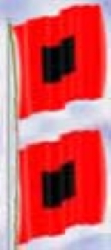
.jpg) A hurricane warning (HUW) is issued when a hurricane with sustained winds of 74 mph (65 knots, 118 km/h) or higher is expected. The National Hurricane Center will issue the HUW when tropical storm conditions are likely in the warned area within the next 36 hours. Maritime flags indicate this with two square red flags with a black square in the middle of each.
A hurricane warning (HUW) is issued when a hurricane with sustained winds of 74 mph (65 knots, 118 km/h) or higher is expected. The National Hurricane Center will issue the HUW when tropical storm conditions are likely in the warned area within the next 36 hours. Maritime flags indicate this with two square red flags with a black square in the middle of each.
A hurricane warning can remain in effect when dangerously high water
or a combination of dangerously high water and exceptionally high waves
continues, even though the winds may have subsided below hurricane intensity.
Where the intensity or track of a forecast cyclone are uncertain (such as a tropical storm bordering hurricane intensity or on the edge of a track), a Tropical Storm Warning and a Hurricane Watch are often in effect at the same time on parts of the coast. Maritime flags indicate this with two square red flags with a black square in the middle on only one of them.
s are issued for any land areas that are in the path of a landfalling category 3 or higher (major) hurricane that are expected to see 115 mph or greater winds, usually associated with the eyewall. (This warning type was created after Hurricane Katrina when several tornado warnings were issued due to the extreme winds, but no actual tornadoes occurred or were forecast to occur.)
event codes HWA and HWW, used for high wind watches and warnings, though they may have later become be under the same codes and regular tropical cyclone advisories. Previously, standard High Wind Warnings and Watches were issued (which denote >=39 MPH winds or >=58 MPH gusts). When they were inland, watches and/or warnings were posted for tropical storm or hurricane force winds in the next 24 hours or so. In 2011, these alerts became deprecated in favor of issuing a unified coastal/inland warning. The coastal strip is determined by the NHC
, and the Local WFOs determine the inland portion of the warning. Below are the deprecated watches and warnings.
, these warnings were not issued in Canada
(who simply issued standard wind and rain warnings, which are now issued alongside the NHC-standard warnings). That policy was changed when it appeared that the population did not realize the dangers from four storms in 2003
that affected different land and offshore areas of Canada, the worst of which was Hurricane Juan
in Nova Scotia
, even if regular warning bulletins were issued well in advance. The inland watches and warnings are not differentiated from the coastal watches and warnings in Canada; the hurricane and tropical storm watches and warnings can be issued for any forecast area. Also, in Canada, a hurricane warning is only issued when a hurricane is within 24 hours of landfall, and a hurricane watch for 36 hours to landfall.
In Cuba
, warnings are issued by province
, not by coastal location or breakpoints. There are no differentials between coastal and inland warnings there as they are automatically issued for both types of areas.
A similar system was implemented in 2011 in the United States. NHC-issued breakpoints are used as guidance and indicate the marine warnings in the area, and the local WFOs expand the warning to include affected inland areas. The expanded warning area is issued by counties, rather than areas as large as cuban provinces.
Nowadays, the use of this system is restricted to coastal waters only. Thus, similar to the US system, warnings may be discontinued even the cyclone is maintaining tropical storm intensity inland. However, color-coded alerts (mentioned below) may be in effect.
Guangdong introduced a color-coded tropical cyclone warning system for land use in 2000.
Similar systems were developed in Fujian and Shanghai.
Later, China Meteorological Administration standardized the system for national use. This set is part of a larger warning system that covers other forms of severe weather conditions, such as extreme temperature, torrential rainfall, drought, etc.
Note that Guangdong maintained a white alert as in the old system.
uses a variety of warning systems to inform the public regarding the risks of tropical cyclones to the area. The Hong Kong Observatory
issues typhoon signals to indicate the existence and approximate location of a tropical cyclone from Hong Kong
. The Macao Meteorological and Geophysical Bureau
in Macau
uses a similar system.
. Each stage relates to a level of preparation that is recommended to be undertaken before a storm arrives. Between June 1 and November 30, TCCOR 4 is constantly in effect. TCCOR 1 is broken into four different situation levels based on current conditions.
(PAGASA) releases tropical cyclone warnings in the form of Public Storm Warning Signals (or just storm signals). An area having a storm signal may be under:
These storm signals are usually heightened when an area (in the Philippines only) is about to be hit by a tropical cyclone. Thus, as a tropical cyclone gains strength and/or gets nearer and nearer to an area having a storm signal, it may be heightened to another higher signal in that particular area. Whereas, as a tropical cyclone weakens and/or gets farther to an area, it may be downgraded to a lower signal or may be lifted (that is, an area will have no storm signal).
Weather forecasting
Weather forecasting is the application of science and technology to predict the state of the atmosphere for a given location. Human beings have attempted to predict the weather informally for millennia, and formally since the nineteenth century...
bodies to coastal areas threatened by the imminent approach of a tropical cyclone
Tropical cyclone
A tropical cyclone is a storm system characterized by a large low-pressure center and numerous thunderstorms that produce strong winds and heavy rain. Tropical cyclones strengthen when water evaporated from the ocean is released as the saturated air rises, resulting in condensation of water vapor...
of tropical storm or hurricane intensity. They are notices to the local population and civil authorities to make appropriate preparation for the cyclone, including evacuation of vulnerable areas where necessary. It is important that interests throughout the area of an alert make preparations to protect life and property, and do not disregard it on the strength of the detailed forecast track. Tropical cyclones are not points, and forecasting their track remains an uncertain science.
North Atlantic systems
The following terminology used by the US National Hurricane Center is the model for countries around the North AtlanticAtlantic Ocean
The Atlantic Ocean is the second-largest of the world's oceanic divisions. With a total area of about , it covers approximately 20% of the Earth's surface and about 26% of its water surface area...
and in the Caribbean
Caribbean
The Caribbean is a crescent-shaped group of islands more than 2,000 miles long separating the Gulf of Mexico and the Caribbean Sea, to the west and south, from the Atlantic Ocean, to the east and north...
basin (except Cuba
Cuba
The Republic of Cuba is an island nation in the Caribbean. The nation of Cuba consists of the main island of Cuba, the Isla de la Juventud, and several archipelagos. Havana is the largest city in Cuba and the country's capital. Santiago de Cuba is the second largest city...
, see regional notes). This is also used for the Pacific coasts of Mexico
Mexico
The United Mexican States , commonly known as Mexico , is a federal constitutional republic in North America. It is bordered on the north by the United States; on the south and west by the Pacific Ocean; on the southeast by Guatemala, Belize, and the Caribbean Sea; and on the east by the Gulf of...
, Central America
Central America
Central America is the central geographic region of the Americas. It is the southernmost, isthmian portion of the North American continent, which connects with South America on the southeast. When considered part of the unified continental model, it is considered a subcontinent...
, southern California
California
California is a state located on the West Coast of the United States. It is by far the most populous U.S. state, and the third-largest by land area...
, and Hawaii
Hawaii
Hawaii is the newest of the 50 U.S. states , and is the only U.S. state made up entirely of islands. It is the northernmost island group in Polynesia, occupying most of an archipelago in the central Pacific Ocean, southwest of the continental United States, southeast of Japan, and northeast of...
.
Tropical storms
Before the 1987 Atlantic hurricane season1987 Atlantic hurricane season
The 1987 Atlantic hurricane season was a below-average hurricane season that was limited by an ongoing El Niño. The season officially began on June 1, 1987, and lasted until November 30, 1987, although activity began on May 25 when a tropical depression developed in the east central...
, tropical storm alerts were described as Gale
Gale
A gale is a very strong wind. There are conflicting definitions of how strong a wind must be to be considered a gale. The U.S. government's National Weather Service defines a gale as 34–47 knots of sustained surface winds. Forecasters typically issue gale warnings when winds of this strength are...
Watches / Warnings, not distinguished from non-tropical storms.
Tropical Storm Watch
A tropical storm watch (TRA) is issued when tropical storm conditions, including windWind
Wind is the flow of gases on a large scale. On Earth, wind consists of the bulk movement of air. In outer space, solar wind is the movement of gases or charged particles from the sun through space, while planetary wind is the outgassing of light chemical elements from a planet's atmosphere into space...
s from 39 to 73 mph (35 to 64 knots, 63 to 117 km/h) pose a possible threat to a specified coastal area within 48 hours (was 36 hours prior to 2010 hurricane season). Maritime flag
Flag
A flag is a piece of fabric with a distinctive design that is usually rectangular and used as a symbol, as a signaling device, or decoration. The term flag is also used to refer to the graphic design employed by a flag, or to its depiction in another medium.The first flags were used to assist...
s indicate this with a single square red flag.
Tropical Storm Warning
A tropical storm warning (TRW) is issued when tropical storm conditions (as above) are expected in a specified coastal area within 36 hours or less (was 24 hours or less prior to 2010 hurricane season). Maritime flags indicate this with a single square red flag with a black square in the middle.Hurricane Watch
A hurricane watch (HWA) is issued when the onset of tropical storm conditions appear possible in the warning area within the next 48 hours (was 36 hours prior to 2010 hurricane season). Maritime flags indicate this with two square red flags.The purpose of a hurricane watch is to inform families to obtain supplies, secure their homes, and be prepared to evacuate.
Hurricane Warning
A hurricane warning can remain in effect when dangerously high water
Storm surge
A storm surge is an offshore rise of water associated with a low pressure weather system, typically tropical cyclones and strong extratropical cyclones. Storm surges are caused primarily by high winds pushing on the ocean's surface. The wind causes the water to pile up higher than the ordinary sea...
or a combination of dangerously high water and exceptionally high waves
Ocean surface wave
In fluid dynamics, wind waves or, more precisely, wind-generated waves are surface waves that occur on the free surface of oceans, seas, lakes, rivers, and canals or even on small puddles and ponds. They usually result from the wind blowing over a vast enough stretch of fluid surface. Waves in the...
continues, even though the winds may have subsided below hurricane intensity.
Where the intensity or track of a forecast cyclone are uncertain (such as a tropical storm bordering hurricane intensity or on the edge of a track), a Tropical Storm Warning and a Hurricane Watch are often in effect at the same time on parts of the coast. Maritime flags indicate this with two square red flags with a black square in the middle on only one of them.
Extreme Wind Warning
Extreme wind warningExtreme wind warning
In National Weather Service terminology, an extreme wind warning is a warning issued when a landfalling hurricane is expected to bring winds of 100 knots to a specific location...
s are issued for any land areas that are in the path of a landfalling category 3 or higher (major) hurricane that are expected to see 115 mph or greater winds, usually associated with the eyewall. (This warning type was created after Hurricane Katrina when several tornado warnings were issued due to the extreme winds, but no actual tornadoes occurred or were forecast to occur.)
Deprecated Inland advisories
The following alerts were issued for inland areas that might have seen tropical storm or hurricane force wind and/or rain conditions, but were not located along the coast prior to 2011. These started appearing in the 2000s, originally with the word "Wind" inserted before the "Watch" or "Warning", which was dropped for 2005. All appeared to be issued with Specific Area Message EncodingSpecific Area Message Encoding
Specific Area Message Encoding or SAME is the protocol used to encode the Emergency Alert System and NOAA Weather Radio's SAME Public Warning System in the U.S...
event codes HWA and HWW, used for high wind watches and warnings, though they may have later become be under the same codes and regular tropical cyclone advisories. Previously, standard High Wind Warnings and Watches were issued (which denote >=39 MPH winds or >=58 MPH gusts). When they were inland, watches and/or warnings were posted for tropical storm or hurricane force winds in the next 24 hours or so. In 2011, these alerts became deprecated in favor of issuing a unified coastal/inland warning. The coastal strip is determined by the NHC
National Hurricane Center
The National Hurricane Center , located at Florida International University in Miami, Florida, is the division of the National Weather Service responsible for tracking and predicting weather systems within the tropics between the Prime Meridian and the 140th meridian west poleward to the 30th...
, and the Local WFOs determine the inland portion of the warning. Below are the deprecated watches and warnings.
Inland Tropical Storm Watch (deprecated)
Formerly issued for inland areas where sustained winds of 39 to 73 mph (62 to 117 km/h) associated with a tropical storm were anticipated beyond the coastal areas though the actual occurrence, timing and location are still uncertain.Inland Tropical Storm Warning (deprecated)
Formerly issued for inland counties where tropical storm conditions were anticipated beyond the coastal areas in the next six to twelve hours.Inland Hurricane Watch (deprecated)
Formerly issued for inland counties where sustained winds of 74 mph (118 km/h) or greater associated with a hurricane were anticipated beyond the coastal areas though the actual occurrence, timing and location are still uncertain.Inland Hurricane Warning (deprecated)
Formerly issued for inland counties where sustained hurricane force winds were anticipated beyond the coastal areas in the next six to twelve hours.Other advisories
Other advisories are also commonly issued in association with tropical cyclones, but are not specific to them.- Tropical cyclones often produce tornadoTornadoA tornado is a violent, dangerous, rotating column of air that is in contact with both the surface of the earth and a cumulonimbus cloud or, in rare cases, the base of a cumulus cloud. They are often referred to as a twister or a cyclone, although the word cyclone is used in meteorology in a wider...
es, prompting the issuing of tornado watchTornado watchA tornado watch is issued when conditions are right for a tornado to form. Since any thunderstorm capable of producing a tornado is defined as severe, a tornado watch is also automatically a severe thunderstorm watch...
es and warningsTornado warningA tornado warning is an alert issued by government weather services to warn that severe thunderstorms with tornadoes may be imminent. It can be issued after a tornado or funnel cloud has been spotted by eye, or more commonly if there are radar indications of tornado formation...
. - A Wind AdvisoryWind advisoryA Wind Advisory is generally issued by the National Weather Service of the United States when there are sustained winds of and/or gusts to over land...
/small craft advisorySmall craft advisoryA small craft advisory is a type of warning issued by the National Weather Service in the United States, most frequently in coastal areas. It is issued when winds have reached, or are expected to reach within 12 hours, a speed marginally less than gale force....
is issued for less severe wind conditions (either at the edges of the storm or after significant weakening) that are strong (at least 25 mph/40 km/h) but sustained below tropical storm force. - Heavy rains associated with tropical systems often result in flood watchFlood watchFlood alerts are issued by weather agencies to alert residents that flood conditions are a possibility for their area.-Types of flood alerts:...
es and warningsFlood warningFlood warning is closely linked to the task of flood forecasting. The distinction between the two is that the outcome of flood forecasting is a set of forecast time-profiles of channel flows or river levels at various locations, while "flood warning" is the task of making use of these forecasts to...
. - If a tropical storm warning or hurricane warning is not in effect for an area which is expected to experience storm surgeStorm surgeA storm surge is an offshore rise of water associated with a low pressure weather system, typically tropical cyclones and strong extratropical cyclones. Storm surges are caused primarily by high winds pushing on the ocean's surface. The wind causes the water to pile up higher than the ordinary sea...
, a coastal flood warningCoastal flood warningA Coastal Flood Warning is issued by the National Weather Service of the United States when coastal flooding is either imminent or occurring along the coast of the Atlantic Ocean, Pacific Ocean, or the Gulf of Mexico. The flooding must be due to water being forced from the nearby body of water onto...
will be issued for that area. - If a storm becomes extratropicalExtratropical cycloneExtratropical cyclones, sometimes called mid-latitude cyclones or wave cyclones, are a group of cyclones defined as synoptic scale low pressure weather systems that occur in the middle latitudes of the Earth having neither tropical nor polar characteristics, and are connected with fronts and...
or degenerates into a wave or low but retains winds of at least tropical storm force, a high wind warning would be issued for inland areas and a gale warningGale warningA gale warning is a warning issued by weather services in maritime locations about the existence of winds of gale force or above or the imminent occurrence of gales at sea...
, storm warningStorm warningAt sea, a storm warning is a warning issued by the National Weather Service of the United States when winds between 48 knots and 63 knots are occurring or predicted to occur soon. The winds must not be associated with a tropical cyclone...
or hurricane force wind warningHurricane force wind warningA Hurricane Force Wind warning is a warning issued by the National Weather Service of the United States when sustained winds or frequent gusts of 64 knots or greater are either being observed or are predicted to occur. The winds must not be directly associated with a tropical cyclone, or a...
would be issued for marine areas.
Regional notes
Before the 2004 Atlantic hurricane season2004 Atlantic hurricane season
The 2004 Atlantic hurricane season officially began on June 1, 2004, and lasted until November 30, 2004. These dates conventionally delimit the period of each year when most tropical cyclones form in the Atlantic basin...
, these warnings were not issued in Canada
Canada
Canada is a North American country consisting of ten provinces and three territories. Located in the northern part of the continent, it extends from the Atlantic Ocean in the east to the Pacific Ocean in the west, and northward into the Arctic Ocean...
(who simply issued standard wind and rain warnings, which are now issued alongside the NHC-standard warnings). That policy was changed when it appeared that the population did not realize the dangers from four storms in 2003
2003 Atlantic hurricane season
The 2003 Atlantic hurricane season was an active Atlantic hurricane season with tropical activity before and after the official bounds of the season – the first such occurrence in 50 years. The season produced 21 tropical cyclones, of which 16 developed into named storms; seven...
that affected different land and offshore areas of Canada, the worst of which was Hurricane Juan
Hurricane Juan
Hurricane Juan was a significant hurricane that struck the southern part of Atlantic Canada in late September 2003. It was the tenth named storm and the sixth hurricane of the 2003 Atlantic hurricane season. Juan formed southeast of Bermuda on September 24, 2003 out of a tropical wave that tracked...
in Nova Scotia
Nova Scotia
Nova Scotia is one of Canada's three Maritime provinces and is the most populous province in Atlantic Canada. The name of the province is Latin for "New Scotland," but "Nova Scotia" is the recognized, English-language name of the province. The provincial capital is Halifax. Nova Scotia is the...
, even if regular warning bulletins were issued well in advance. The inland watches and warnings are not differentiated from the coastal watches and warnings in Canada; the hurricane and tropical storm watches and warnings can be issued for any forecast area. Also, in Canada, a hurricane warning is only issued when a hurricane is within 24 hours of landfall, and a hurricane watch for 36 hours to landfall.
In Cuba
Cuba
The Republic of Cuba is an island nation in the Caribbean. The nation of Cuba consists of the main island of Cuba, the Isla de la Juventud, and several archipelagos. Havana is the largest city in Cuba and the country's capital. Santiago de Cuba is the second largest city...
, warnings are issued by province
Provinces of Cuba
Administratively, Cuba is divided into 15 provinces and one special municipality not included in any province. The last modification was approved in August 2010 , splitting Havana province into two new provinces: Artemisa and Mayabeque...
, not by coastal location or breakpoints. There are no differentials between coastal and inland warnings there as they are automatically issued for both types of areas.
A similar system was implemented in 2011 in the United States. NHC-issued breakpoints are used as guidance and indicate the marine warnings in the area, and the local WFOs expand the warning to include affected inland areas. The expanded warning area is issued by counties, rather than areas as large as cuban provinces.
China
A two-stage warning system was long-established in China for tropical cyclones of tropical storm intensity of above.- Warning: Winds may reach Beaufort Force 8 or rainstorm may occur in 48 hours.
- Urgent Warning: Winds may reach Beaufort Force 8 or rainstorm may occur in 24 hours.
Nowadays, the use of this system is restricted to coastal waters only. Thus, similar to the US system, warnings may be discontinued even the cyclone is maintaining tropical storm intensity inland. However, color-coded alerts (mentioned below) may be in effect.
Guangdong introduced a color-coded tropical cyclone warning system for land use in 2000.
- White alert: A tropical cyclone may affect the area in 48 hours.
- Green alert: Winds may reach Beaufort Force 6 in 24 hours or winds of Beaufort Force 6~7 are already blowing.
- Yellow alert: Winds may reach Beaufort Force 8 in 12 hours or winds of Beaufort Force 8~9 (gale force) are already blowing.
- Red alert: Winds may reach Beaufort Force 10 in 12 hours or winds of Beaufort Force 10~11 (storm force) are already blowing.
- Black alert: Winds may reach Beaufort Force 12 in 12 hours or winds of Beaufort Force 12 (hurricane force) are already blowing.
Similar systems were developed in Fujian and Shanghai.
Later, China Meteorological Administration standardized the system for national use. This set is part of a larger warning system that covers other forms of severe weather conditions, such as extreme temperature, torrential rainfall, drought, etc.
- Blue alert: Winds may reach Beaufort Force 6 in 24 hours or winds of Beaufort Force 6~7 are already blowing.
- Yellow alert: Winds may reach Beaufort Force 8 in 24 hours or winds of Beaufort Force 8~9 (gale force) are already blowing.
- Orange alert: Winds may reach Beaufort Force 10 in 12 hours or winds of Beaufort Force 10~11 (storm force) are already blowing.
- Red alert: Winds may reach Beaufort Force 12 in 6 hours or winds of Beaufort Force 12 (hurricane force) are already blowing.
Note that Guangdong maintained a white alert as in the old system.
Pearl River Delta
The Pearl River DeltaPearl River Delta
The Pearl River Delta , Zhujiang Delta or Zhusanjiao in Guangdong province, People's Republic of China is the low-lying area surrounding the Pearl River estuary where the Pearl River flows into the South China Sea...
uses a variety of warning systems to inform the public regarding the risks of tropical cyclones to the area. The Hong Kong Observatory
Hong Kong Observatory
Hong Kong Observatory is a department of the Hong Kong government. The Observatory forecasts weather and issues warnings on weather-related hazards...
issues typhoon signals to indicate the existence and approximate location of a tropical cyclone from Hong Kong
Hong Kong
Hong Kong is one of two Special Administrative Regions of the People's Republic of China , the other being Macau. A city-state situated on China's south coast and enclosed by the Pearl River Delta and South China Sea, it is renowned for its expansive skyline and deep natural harbour...
. The Macao Meteorological and Geophysical Bureau
Macao Meteorological and Geophysical Bureau
The Macao Meteorological and Geophysical Bureau is a department of the Macao Government. The services provides forecasts weather and issues warnings on weather-related hazards...
in Macau
Macau
Macau , also spelled Macao , is, along with Hong Kong, one of the two special administrative regions of the People's Republic of China...
uses a similar system.
Okinawa
A multi-stage system called the Tropical Cyclone Condition of Readiness (TCCOR), is used for the United States military base and residents on Okinawa, JapanJapan
Japan is an island nation in East Asia. Located in the Pacific Ocean, it lies to the east of the Sea of Japan, China, North Korea, South Korea and Russia, stretching from the Sea of Okhotsk in the north to the East China Sea and Taiwan in the south...
. Each stage relates to a level of preparation that is recommended to be undertaken before a storm arrives. Between June 1 and November 30, TCCOR 4 is constantly in effect. TCCOR 1 is broken into four different situation levels based on current conditions.
- TCCOR 4 – Destructive winds of 57 mph (50 kt, 93 km/h) or greater are possible within 72 hours.
- Now is the time to stock-up on food and Typhoon Supplies.
- TCCOR 3 – Destructive winds of 57 mph (50 kt, 93 km/h) or greater are possible within 48 hours.
- Initiate a general cleanup around homes and office.
- TCCOR 2 – Destructive winds of 57 mph (50 kt, 93 km/h) or greater are anticipated within 24 hours.
- Remove or secure all outside items.
- TCCOR 1 – Destructive winds of 57 mph (50 kt, 93 km/h) or greater are anticipated within 12 hours.
- No school for Department of Defense District School (DoDDS) students. Staff and teachers will work normal hours, unless changed by DoDDS superintendent. Fill any containers you can use for water storage. If you live in low lying quarters, make arrangements to stay with a friend. Make final check of food and other supplies.
- TCCOR 1 Caution – Destructive winds of 57 mph (50 kt, 93 km/h) or greater are anticipated within 12 hours. Actual winds are 39 to 56 mph (34 to 49 knots, 63 to 91 km/h).
- All nonessential personnel will be released to their quarters at this time. DoDDS schools will close at this time. Staff and teachers return home or remain home. Base exchange, shops, Commissary, Shoppettes, Gas Station, Services facilities, Clubs, Restaurants, Recreational Facilities and Post Office will close. Movement about the base should be kept to a minimum. SFS will enforce "essential vehicles only"policy.
- TCCOR 1 Emergency – Actual winds of 57 mph (50 kt, 93 km/h) or greater are occurring.
- All outside activity is prohibited.
- TCCOR 1 Recovery – Destructive winds of 57 mph (50 kt, 93 km/h) or greater are no longer occurring. Actual winds are 39 to 56 mph (34 to 49 knots, 63 to 91 km/h).
- Nonessential functions remain closed unless directed by the commander. All but emergency essential personnel remain in their quarters.
- Storm Watch – The typhoon is moving away but the base is still feeling some effects. Hazardous conditions may exist due to storm damage. In some cases the storm could return to Okinawa , so stay alert.
- All military and civilian personnel will return to work within 2 hours or at normal duty hours unless otherwise instructed by their commander. The Commissary and BX will resume operations, unless directed otherwise by the installation commander.
- All Clear – Hazardous conditions and winds are no longer present. Return to normal duties. All Clear is announced when all hazards have been cleared.
- DoDDS teachers, staff and students will return to school during normal hours. From June 1st to November 30th Okinawa will return to TCCOR 4.
Philippines
The Philippine Atmospheric, Geophysical and Astronomical Services AdministrationPhilippine Atmospheric, Geophysical and Astronomical Services Administration
The Philippine Atmospheric, Geophysical and Astronomical Services Administration is a Philippine national institution dedicated to provide flood and typhoon warnings, public weather forecasts and advisories, meteorological, astronomical, climatological, and other specialized information and...
(PAGASA) releases tropical cyclone warnings in the form of Public Storm Warning Signals (or just storm signals). An area having a storm signal may be under:
- PSWS #1 - Tropical cyclone winds of 30–60 km/h are expected within the next 36 hours. (Note: If a tropical cyclone forms very close to the area, then a shorter lead time is seen on the warning bulletin.)
- PSWS #2 - Tropical cyclone winds of 60–100 km/h are expected within the next 24 hours.
- PSWS #3 - Tropical cyclone winds of 100–185 km/h are expected within the next 18 hours.
- PSWS #4 - Tropical cyclone winds of greater than 185 km/h are expected within 12 hours.
These storm signals are usually heightened when an area (in the Philippines only) is about to be hit by a tropical cyclone. Thus, as a tropical cyclone gains strength and/or gets nearer and nearer to an area having a storm signal, it may be heightened to another higher signal in that particular area. Whereas, as a tropical cyclone weakens and/or gets farther to an area, it may be downgraded to a lower signal or may be lifted (that is, an area will have no storm signal).
See also
- Gale warningGale warningA gale warning is a warning issued by weather services in maritime locations about the existence of winds of gale force or above or the imminent occurrence of gales at sea...
- HURCONHURCONHurricane Condition is an alert scale used by the United States Armed Forces, primarily the United States Air Force, to indicate the state of emergency or preparedness for an approaching hurricane. This designation is especially important to installations in the southern Atlantic region, as it is...
- Severe weather terminologySevere weather terminologySevere weather terminology is different around the world, varying between regions and countries. These are articles which explain terminology in various parts of the world.*Severe weather terminology *Severe weather terminology...
- Small craft advisorySmall craft advisoryA small craft advisory is a type of warning issued by the National Weather Service in the United States, most frequently in coastal areas. It is issued when winds have reached, or are expected to reach within 12 hours, a speed marginally less than gale force....
- Storm warningStorm warningAt sea, a storm warning is a warning issued by the National Weather Service of the United States when winds between 48 knots and 63 knots are occurring or predicted to occur soon. The winds must not be associated with a tropical cyclone...
- Tropical cycloneTropical cycloneA tropical cyclone is a storm system characterized by a large low-pressure center and numerous thunderstorms that produce strong winds and heavy rain. Tropical cyclones strengthen when water evaporated from the ocean is released as the saturated air rises, resulting in condensation of water vapor...