

Woods Hole, Massachusetts
Encyclopedia
Woods Hole is a census-designated place
(CDP) in the town of Falmouth in Barnstable County
, Massachusetts
, United States
. It lies at the extreme southwest corner of Cape Cod
, near Martha's Vineyard
and the Elizabeth Islands
. The population was 925 at the 2000 census
.
It is the site of several famous marine science institutions, including Woods Hole Oceanographic Institution
, the Marine Biological Laboratory
, the Woods Hole Research Center
, NOAA's
Northeast Fisheries Science Center (which started the Woods Hole scientific community in 1871), a USGS
coastal and marine geology center, and the home campus of the Sea Education Association
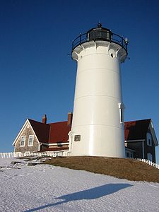
. It is also the site of United States Coast Guard Sector Southeastern New England (formerly USCG Group Woods Hole), the Nobska Light
lighthouse, and the terminus of the Steamship Authority
ferry
route between Cape Cod and the island of Martha's Vineyard
.
) on the southern side of Cape Cod (i.e. Great Harbor, contained by Penzance Point) and became a center for whaling, shipping, and fishing, prior to its dominance today by tourism and marine research. At the end of the nineteenth century, Woods Hole was the home of the Pacific Guano Company, which produced fertilizer
from guano
imported from islands in the Pacific Ocean, the Caribbean, and the coast of South Carolina. After the firm went bankrupt in 1889, Long Neck– the peninsula on which their factory was located– was renamed Penzance Point and was developed with Shingle-Style summer homes for bankers and lawyers from New York and Boston. Notable property owners on Penzance Point at the beginning of the twentieth century included Seward Prosser of New York's Bankers Trust Company; Francis Bartow, a partner in J. P. Morgan and Company; Joseph Lee
, a partner in Lee, Higginson & Co.
; and Franklin A. Park, an executive of Singer Sewing Machine. Other notable businessmen established homes on Gansett Point, Nobska Point, and at Quissett Harbor, further from the village center.
The term "Woods Hole" refers to a passage for ships between Vineyard Sound
and Buzzards Bay
known for its extremely strong current, approaching four knots http://www.mobilegeographics.com:81/locations/7064.html.
 The Knob is a local landmark: a rocky outcropping that overlooks Buzzards Bay and Quisset Harbor, a part of the privately owned Salt Pond bird sanctuaries.
run regularly between Woods Hole and Martha's Vineyard. In the past ferries also ran between Woods Hole and Nantucket, but these have been discontinued in recent decades.
brings thousands of runners to Woods Hole in August each year. The route of the seven-mile (11 km) race starts outside the front door of the Captain Kidd, a tavern, and follows the shore of Vineyard Sound through Falmouth to the British Beer Company, another tavern, in Falmouth Heights.
Some mention of Woods Hole Oceanographic Institution
is made in the 1975 blockbuster film Jaws
as having been the center of research for the fictional character Matt Hooper. Hooper is described as a marine biologist, focusing on the study of sharks. Coincidentally, a Great White Shark
was spotted some years later at Woods Hole in September 2004.
, which separates Cape Cod
from the Elizabeth Islands
(specifically, Uncatena Island
and Nonamesset Island
). It is one of four straits allowing maritime passage between Buzzards Bay
and the Vineyard Sound
. The others are Canapitsit Channel
, Quick's Hole
and Robinson's Hole
.
According to the United States Census Bureau
, the CDP has a total area of 10.0 km² (3.9 mi²). 5.6 km² (2.2 mi²) of it is land and 4.5 km² (1.7 mi²) of it (44.33%) is water.
Much of Woods Hole http://www.woodshole.com centers around the enclosed harbor of Eel Pond. A drawbridge
at the mouth of the harbor allows boats to enter and exit the harbor according to a fixed schedule.
The local lighthouse at Nobska Point is operated by the USCG, and the accompanying house is the home of the commander of the USCG base at Little Harbor.
of 2000, there were 925 people, 459 households, and 212 families residing in the CDP. The population density
was 165.3/km² (427.9/mi²). There were 942 housing units at an average density of 168.4/km² (435.8/mi²). The racial makeup of the CDP was 94.70% White, 1.62% African American, 0.54% Native American, 1.84% Asian, 0.22% from other races
, and 1.08% from two or more races. Hispanic or Latino of any race were 0.97% of the population.
There were 459 households out of which 14.8% had children under the age of 18 living with them, 39.7% were married couples
living together, 5.4% had a female householder with no husband present, and 53.6% were non-families. 40.5% of all households were made up of individuals and 17.9% had someone living alone who was 65 years of age or older. The average household size was 1.94 and the average family size was 2.58.
In the CDP the population was spread out with 13.5% under the age of 18, 7.1% from 18 to 24, 25.7% from 25 to 44, 26.4% from 45 to 64, and 27.2% who were 65 years of age or older. The median age was 48 years. For every 100 females, there are 94.7 males. For every 100 females age 18 and over, there were 88.7 males.
The median income for a household in the CDP was $47,604, and the median income for a family was $57,969. Males had a median income of $31,964 versus $31,875 for females. The per capita income
for the CDP was $30,752. None of the families and 5.3% of the population were living below the poverty line, including no under 18 and 6.4% of those over 64.
Census-designated place
A census-designated place is a concentration of population identified by the United States Census Bureau for statistical purposes. CDPs are delineated for each decennial census as the statistical counterparts of incorporated places such as cities, towns and villages...
(CDP) in the town of Falmouth in Barnstable County
Barnstable County, Massachusetts
Barnstable County is a county located in the U.S. state of Massachusetts, consisting of Cape Cod and associated islands. As of the 2010 census, the population was 216,902...
, Massachusetts
Massachusetts
The Commonwealth of Massachusetts is a state in the New England region of the northeastern United States of America. It is bordered by Rhode Island and Connecticut to the south, New York to the west, and Vermont and New Hampshire to the north; at its east lies the Atlantic Ocean. As of the 2010...
, United States
United States
The United States of America is a federal constitutional republic comprising fifty states and a federal district...
. It lies at the extreme southwest corner of Cape Cod
Cape Cod
Cape Cod, often referred to locally as simply the Cape, is a cape in the easternmost portion of the state of Massachusetts, in the Northeastern United States...
, near Martha's Vineyard
Martha's Vineyard
Martha's Vineyard is an island located south of Cape Cod in Massachusetts, known for being an affluent summer colony....
and the Elizabeth Islands
Elizabeth Islands
The Elizabeth Islands are a chain of small islands extending southwest from the southern coast of Cape Cod, Massachusetts in the United States. They are located at the outer edge of Buzzards Bay, north of Martha's Vineyard from which they are separated by Vineyard Sound, and constitute the town of...
. The population was 925 at the 2000 census
United States Census, 2000
The Twenty-second United States Census, known as Census 2000 and conducted by the Census Bureau, determined the resident population of the United States on April 1, 2000, to be 281,421,906, an increase of 13.2% over the 248,709,873 persons enumerated during the 1990 Census...
.
It is the site of several famous marine science institutions, including Woods Hole Oceanographic Institution
Woods Hole Oceanographic Institution
The Woods Hole Oceanographic Institution is a private, nonprofit research and higher education facility dedicated to the study of all aspects of marine science and engineering and to the education of marine researchers. Established in 1930, it is the largest independent oceanographic research...
, the Marine Biological Laboratory
Marine Biological Laboratory
The Marine Biological Laboratory is an international center for research and education in biology, biomedicine and ecology. Founded in 1888, the MBL is the oldest independent marine laboratory in the Americas, taking advantage of a coastal setting in the Cape Cod village of Woods Hole, Massachusetts...
, the Woods Hole Research Center
Woods Hole Research Center
The Woods Hole Research Center addresses pressing environmental issues, including climate change, through scientific and policy initiatives. The Center has projects in the Amazon, the Arctic, Africa, Russia, Alaska, Canada, New England, and the Mid-Atlantic, working in collaboration with a wide...
, NOAA's
National Oceanic and Atmospheric Administration
The National Oceanic and Atmospheric Administration , pronounced , like "noah", is a scientific agency within the United States Department of Commerce focused on the conditions of the oceans and the atmosphere...
Northeast Fisheries Science Center (which started the Woods Hole scientific community in 1871), a USGS
United States Geological Survey
The United States Geological Survey is a scientific agency of the United States government. The scientists of the USGS study the landscape of the United States, its natural resources, and the natural hazards that threaten it. The organization has four major science disciplines, concerning biology,...
coastal and marine geology center, and the home campus of the Sea Education Association
Sea Education Association
The Sea Education Association is a private, nonprofit educational organization which offers a hands-on experience to college and high school students in sailing at sea. Founded in 1971 by Corwith Cramer, Jr. SEA operates two sailing ships traveling throughout both the Atlantic and Pacific Oceans...
. It is also the site of United States Coast Guard Sector Southeastern New England (formerly USCG Group Woods Hole), the Nobska Light
Nobska Light
Nobska Light, or Nobsque Light, also known as Nobska Point Light is a lighthouse located at the division between Buzzards Bay and Vineyard Sound in Woods Hole on the southwestern tip of Cape Cod, Massachusetts....
lighthouse, and the terminus of the Steamship Authority
The Woods Hole, Martha's Vineyard and Nantucket Steamship Authority
The Woods Hole, Martha's Vineyard and Nantucket Steamship Authority, referred to coloquially as The Steamship Authority or simply the SSA, is the statutory regulatory body for all ferry operations to and from the Islands from the Massachusetts mainland, as well as being an operator of ferry service...
ferry
Ferry
A ferry is a form of transportation, usually a boat, but sometimes a ship, used to carry primarily passengers, and sometimes vehicles and cargo as well, across a body of water. Most ferries operate on regular, frequent, return services...
route between Cape Cod and the island of Martha's Vineyard
Martha's Vineyard
Martha's Vineyard is an island located south of Cape Cod in Massachusetts, known for being an affluent summer colony....
.
History
Historically, Woods Hole included one of the few good harbors (along with HyannisHyannis
Hyannis may refer to a location in the United States:* Hyannis, Massachusetts* Hyannisport, Massachusetts* Hyannis, Nebraska...
) on the southern side of Cape Cod (i.e. Great Harbor, contained by Penzance Point) and became a center for whaling, shipping, and fishing, prior to its dominance today by tourism and marine research. At the end of the nineteenth century, Woods Hole was the home of the Pacific Guano Company, which produced fertilizer
Fertilizer
Fertilizer is any organic or inorganic material of natural or synthetic origin that is added to a soil to supply one or more plant nutrients essential to the growth of plants. A recent assessment found that about 40 to 60% of crop yields are attributable to commercial fertilizer use...
from guano
Guano
Guano is the excrement of seabirds, cave dwelling bats, and seals. Guano manure is an effective fertilizer due to its high levels of phosphorus and nitrogen and also its lack of odor. It was an important source of nitrates for gunpowder...
imported from islands in the Pacific Ocean, the Caribbean, and the coast of South Carolina. After the firm went bankrupt in 1889, Long Neck– the peninsula on which their factory was located– was renamed Penzance Point and was developed with Shingle-Style summer homes for bankers and lawyers from New York and Boston. Notable property owners on Penzance Point at the beginning of the twentieth century included Seward Prosser of New York's Bankers Trust Company; Francis Bartow, a partner in J. P. Morgan and Company; Joseph Lee
Joseph Lee
Joseph Lee may refer to:* Joe Lee, professor of Irish history* Joseph Lee , Scottish poet* Joseph Lee , father of the playground movement* J. Bracken Lee, former Governor of Utah...
, a partner in Lee, Higginson & Co.
Lee, Higginson & Co.
Lee, Higginson & Co. was a prominent Boston-based investment bank during the 1840s to 1932, home of many members of Boston Brahmin establishment. The bank collapsed in the Swedish match scandal in 1932 while under the leadership of Jerome Davis Greene. Also known for financing the growth of...
; and Franklin A. Park, an executive of Singer Sewing Machine. Other notable businessmen established homes on Gansett Point, Nobska Point, and at Quissett Harbor, further from the village center.
The term "Woods Hole" refers to a passage for ships between Vineyard Sound
Vineyard Sound
Vineyard Sound is the stretch of the Atlantic Ocean which separates the Elizabeth Islands and the southwestern part of Cape Cod from the island of Martha's Vineyard, offshore from the state of Massachusetts in the USA...
and Buzzards Bay
Buzzards Bay (bay)
Buzzards Bay is a bay of the Atlantic Ocean adjacent to the U.S. state of Massachusetts. It is approximately 28 miles long by 8 miles wide. It is a popular destination for fishing, boating, and tourism. Since 1914, Buzzards Bay has been connected to Cape Cod Bay by the Cape Cod Canal...
known for its extremely strong current, approaching four knots http://www.mobilegeographics.com:81/locations/7064.html.
Connection to the Islands
Ferries operated by the Steamship AuthorityThe Woods Hole, Martha's Vineyard and Nantucket Steamship Authority
The Woods Hole, Martha's Vineyard and Nantucket Steamship Authority, referred to coloquially as The Steamship Authority or simply the SSA, is the statutory regulatory body for all ferry operations to and from the Islands from the Massachusetts mainland, as well as being an operator of ferry service...
run regularly between Woods Hole and Martha's Vineyard. In the past ferries also ran between Woods Hole and Nantucket, but these have been discontinued in recent decades.
Falmouth Road Race
The annual Falmouth Road RaceFalmouth Road Race
The Falmouth Road Race is an annual 7-mile road race on Cape Cod from Woods Hole, a village in the town of Falmouth, Massachusetts, to Falmouth Heights.-History:...
brings thousands of runners to Woods Hole in August each year. The route of the seven-mile (11 km) race starts outside the front door of the Captain Kidd, a tavern, and follows the shore of Vineyard Sound through Falmouth to the British Beer Company, another tavern, in Falmouth Heights.
Education
Woods Hole is the home of the Children's School of Science, Inc. Founded in 1913, this institution (locally known as "CSS" and "Science School") provides science classes for students between 8 and 15 years old that focus on scientific investigation by observation. Students regularly visit ecosystems around the village to study the organisms in their natural environments. The Children's School of Science draws upon the talent brought to the village by the research institutions but also educates the children of both scientists and locals.Some mention of Woods Hole Oceanographic Institution
Woods Hole Oceanographic Institution
The Woods Hole Oceanographic Institution is a private, nonprofit research and higher education facility dedicated to the study of all aspects of marine science and engineering and to the education of marine researchers. Established in 1930, it is the largest independent oceanographic research...
is made in the 1975 blockbuster film Jaws
Jaws (film)
Jaws is a 1975 American horror-thriller film directed by Steven Spielberg and based on Peter Benchley's novel of the same name. In the story, the police chief of Amity Island, a fictional summer resort town, tries to protect beachgoers from a giant man-eating great white shark by closing the beach,...
as having been the center of research for the fictional character Matt Hooper. Hooper is described as a marine biologist, focusing on the study of sharks. Coincidentally, a Great White Shark
Great white shark
The great white shark, scientific name Carcharodon carcharias, also known as the great white, white pointer, white shark, or white death, is a large lamniform shark found in coastal surface waters in all major oceans. It is known for its size, with the largest individuals known to have approached...
was spotted some years later at Woods Hole in September 2004.
Significance to maritime navigation
Woods Hole, the village, is located at Woods Hole the straitStrait
A strait or straits is a narrow, typically navigable channel of water that connects two larger, navigable bodies of water. It most commonly refers to a channel of water that lies between two land masses, but it may also refer to a navigable channel through a body of water that is otherwise not...
, which separates Cape Cod
Cape Cod
Cape Cod, often referred to locally as simply the Cape, is a cape in the easternmost portion of the state of Massachusetts, in the Northeastern United States...
from the Elizabeth Islands
Elizabeth Islands
The Elizabeth Islands are a chain of small islands extending southwest from the southern coast of Cape Cod, Massachusetts in the United States. They are located at the outer edge of Buzzards Bay, north of Martha's Vineyard from which they are separated by Vineyard Sound, and constitute the town of...
(specifically, Uncatena Island
Uncatena Island
Uncatena Island is one of the Elizabeth Islands of Dukes County, Massachusetts, USA. It is the most northerly of the Elizabeth Islands and lies just northeast of the largest island, Naushon Island. Uncatena has a land area of 0.492 km² , and was uninhabited as of the 2000 census....
and Nonamesset Island
Nonamesset Island
Nonamesset Island is the most easterly of the Elizabeth Islands of Dukes County, Massachusetts, USA. The island has a land area of 1.398 km² and was uninhabited as of the 2000 census. The island is part of the town of Gosnold, Massachusetts....
). It is one of four straits allowing maritime passage between Buzzards Bay
Buzzards Bay
Buzzards Bay is a bay along the southern edge of Massachusetts in the United States. The name may also refer to:*Buzzards Bay, Massachusetts, a village in Bourne, Massachusetts*Buzzards Bay , the name of the horse that won the 2005 Santa Anita Derby...
and the Vineyard Sound
Vineyard Sound
Vineyard Sound is the stretch of the Atlantic Ocean which separates the Elizabeth Islands and the southwestern part of Cape Cod from the island of Martha's Vineyard, offshore from the state of Massachusetts in the USA...
. The others are Canapitsit Channel
Canapitsit Channel
Canapitsit Channel is a channel that separates Nashawena Island from Cuttyhunk Island, two of the Elizabeth Islands off Cape Cod, Massachusetts. It is one of four straits allowing maritime passage between Buzzards Bay and the Vineyard Sound. The others are Quick's Hole, Robinson's Hole and Woods...
, Quick's Hole
Quick's Hole
Quick's Hole is the strait in Massachusetts' Elizabeth Islands separating Nashawena Island from Pasque Island. It is one of four straits allowing maritime passage between Buzzards Bay and the Vineyard Sound. The others are Canapitsit Channel, Robinson's Hole and Woods Hole...
and Robinson's Hole
Robinson's Hole
Robinson's Hole is the strait in Massachusetts' Elizabeth Islands separating Naushon Island from Pasque Island. It is one of four straits allowing maritime passage between Buzzards Bay and the Vineyard Sound. The others are Canapitsit Channel, Quick's Hole and Woods Hole.Robinson's Hole is located...
.
Geography
Woods Hole is located at 41°31′36"N 70°39′47"W (41.526730, -70.663184).According to the United States Census Bureau
United States Census Bureau
The United States Census Bureau is the government agency that is responsible for the United States Census. It also gathers other national demographic and economic data...
, the CDP has a total area of 10.0 km² (3.9 mi²). 5.6 km² (2.2 mi²) of it is land and 4.5 km² (1.7 mi²) of it (44.33%) is water.
Much of Woods Hole http://www.woodshole.com centers around the enclosed harbor of Eel Pond. A drawbridge
Drawbridge
A drawbridge is a type of movable bridge typically associated with the entrance of a castle surrounded by a moat. The term is often used to describe all different types of movable bridges, like bascule bridges and lift bridges.-Castle drawbridges:...
at the mouth of the harbor allows boats to enter and exit the harbor according to a fixed schedule.
The local lighthouse at Nobska Point is operated by the USCG, and the accompanying house is the home of the commander of the USCG base at Little Harbor.
Demographics
As of the censusCensus
A census is the procedure of systematically acquiring and recording information about the members of a given population. It is a regularly occurring and official count of a particular population. The term is used mostly in connection with national population and housing censuses; other common...
of 2000, there were 925 people, 459 households, and 212 families residing in the CDP. The population density
Population density
Population density is a measurement of population per unit area or unit volume. It is frequently applied to living organisms, and particularly to humans...
was 165.3/km² (427.9/mi²). There were 942 housing units at an average density of 168.4/km² (435.8/mi²). The racial makeup of the CDP was 94.70% White, 1.62% African American, 0.54% Native American, 1.84% Asian, 0.22% from other races
Race (United States Census)
Race and ethnicity in the United States Census, as defined by the Federal Office of Management and Budget and the United States Census Bureau, are self-identification data items in which residents choose the race or races with which they most closely identify, and indicate whether or not they are...
, and 1.08% from two or more races. Hispanic or Latino of any race were 0.97% of the population.
There were 459 households out of which 14.8% had children under the age of 18 living with them, 39.7% were married couples
Marriage
Marriage is a social union or legal contract between people that creates kinship. It is an institution in which interpersonal relationships, usually intimate and sexual, are acknowledged in a variety of ways, depending on the culture or subculture in which it is found...
living together, 5.4% had a female householder with no husband present, and 53.6% were non-families. 40.5% of all households were made up of individuals and 17.9% had someone living alone who was 65 years of age or older. The average household size was 1.94 and the average family size was 2.58.
In the CDP the population was spread out with 13.5% under the age of 18, 7.1% from 18 to 24, 25.7% from 25 to 44, 26.4% from 45 to 64, and 27.2% who were 65 years of age or older. The median age was 48 years. For every 100 females, there are 94.7 males. For every 100 females age 18 and over, there were 88.7 males.
The median income for a household in the CDP was $47,604, and the median income for a family was $57,969. Males had a median income of $31,964 versus $31,875 for females. The per capita income
Per capita income
Per capita income or income per person is a measure of mean income within an economic aggregate, such as a country or city. It is calculated by taking a measure of all sources of income in the aggregate and dividing it by the total population...
for the CDP was $30,752. None of the families and 5.3% of the population were living below the poverty line, including no under 18 and 6.4% of those over 64.
External links
- Local Businesses & Village Information
- Woods Hole Historical Museum
- Woods Hole, the early years
- Childrens School of Science
- 1887 Bird's Eye View of Woods Hole
- Great White Shark at Woods Hole
- Woods Hole Oceanographic Institution
- the Marine Biological Laboratory
- Images of Woods Hole, Dana Morris
- Woods Hole Public Library