
Block Island
Encyclopedia
Block Island is part of the U.S. state
of Rhode Island
and is located in the Atlantic Ocean approximately 13 miles (21 km) south of the coast of Rhode Island, 14 miles (23 km) east of Montauk Point on Long Island
, and is separated from the Rhode Island mainland by Block Island Sound
. The United States Census Bureau
defines Block Island as Census Tract
415 of Washington County, Rhode Island
. As of the 2000 census
the population of 1,010 lived on a land area of 9.734 square miles (25.211 km²). The island is part of the Outer Lands
region, a coastal archipelago made by the recessional and terminal moraine
that resulted from the Wisconsonian Laurentide glacier retreat
, about 22,000 years ago.
The Nature Conservancy
added Block Island to its list of "The Last Great Places." The list consists of twelve sites in the Western Hemisphere. Approximately 40 percent of the Island is set aside for conservation. Presidents Bill Clinton
, Dwight D. Eisenhower
, Franklin Delano Roosevelt, and Ulysses S. Grant
have visited Block Island.
Block island is also referred to as New Shoreham, RI. The island is a popular summer tourist destination and is known for its bicycling, hiking, sailing, fishing, and beaches. Two historic lighthouses are present on the island: Block Island North Light
, on the northern tip of the island, and Block Island Southeast Light
, on the southeast side of the island. Much of the northwest tip of the island is an undeveloped natural area and resting stop for birds along the Atlantic Flyway
.
Every summer the island hosts Block Island Race Week, a competitive, week-long sailboat race. On odd years, the event is held by the Storm Trysail Club, and on even years by the Block Island Race Week. Yachts compete in various classes, sailing courses in Block Island Sound, and circumnavigating the island.
Other popular events include the annual Fourth of July Parade and celebration. During these times the island's population can triple over the normal summer vacation crowd.
, whose tribe eventually merged with the Narragansett
people, called the island "Manisses" which means "little island of Manitou
". Archaeological sites indicate these people lived largely by hunting deer
, catching fish
and shellfish
, and growing corn
, beans, and squash. They migrated from forest to coastal areas to take advantage of seasonal resources. Artifacts found in the area suggest that American Indians inhabited the area as far back as 1300 BC. In 1662, natives on the island numbered somewhere from 1,200 to 1,500. By 1774, that number had been reduced to fifty-one.
Due to intrusions by the Pequot
and Mohegan
in the early 17th century, the Niantic were split into two divisions; the Western Niantic, who allied with the Pequot and Mohegan, and the Eastern Niantic, who allied with the Narragansett
.
In 1634, Western Niantic defended their tribe by killing John Stone, a renegade Boston
man, who was known for stealing Pilgrim
vessels, near the mouth of the Connecticut River
. Despite the fact the man was trying to kidnap native women and children to sell as slaves in Virginia
, the colonists became furious (partly due to earlier Indian atrocities against settlers on the mainland by a related tribe) . The English demanded that the Pequot Indians (who spoke for the Western Niantic) surrender his killers. This was refused and began the slide towards war. In the summer of 1637, the Western Niantic killed another Boston man, the trader John Oldham, near Block Island.
Without consulting the Connecticut
colonists, Massachusetts
, in August, sent a punitive expedition of ninety men under John Endicott to Block Island with instructions to kill every Niantic warrior and capture the woman and children, who would be valuable as slaves. The expedition was ordered by Massachusetts Governor Henry Vane
to "massacre all of the Native men on the island". The expedition killed fourteen Eastern Niantic and burned their village and crops. The English burned sixty wigwam
s and the corn fields. They also shot every dog, but the Niantic fled into the woods, and the soldiers only managed to kill fourteen of them. Deciding this punishment was insufficient, Endicott and his men sailed over to Fort Saybrook before going after the Pequot village at the mouth of the Thames River
to demand one thousand fathom
s of wampum
to pay for the murder of John Oldham and some Pequot children as hostages to insure peace. This incident is seen as one of the initial events that led to the Pequot War
.
 In 1524, what later became known as Block Island was sighted by Giovanni da Verrazzano, who named it "Luisa" after Louise of Savoy
, the Queen Mother
of France, and the mother of Francis I. However, several maps of the era named the island "Claudia", in honor of Claude, the wife of Francis I. Verrazano described Luisa (Claudia) as "about the size of the Island of Rhodes
." In fact, they are shaped very similarly. When the founders of Colony of Rhode Island and Providence Plantations
surveyed the land, they thought that Aquidneck Island
was the place referred to by Verrazano. In 1614, Block Island was charted by the Dutch
explorer Adrian Block, who named it for himself. English settlers from the mainland first arrived in 1661 led by Captain John Underhill
, when the island was part of the Massachusetts Bay Colony
. The island became part of the colony of Rhode Island in 1672 and the island government adopted the name "New Shoreham". A Dutch map of 1685 clearly shows Block Island, indicated as Adrian Block Island ("Adriaen Blocks Eylant").
In 1699, the Scottish sailor William Kidd
visited Block Island, shortly before he was accused of piracy and hanged. At Block Island he was supplied by Mrs. Mercy (Sands) Raymond, daughter of the mariner James Sands. The story has it that, for her hospitality, Mrs. Raymond was bid to hold out her apron, into which Kidd threw gold and jewels until it was full. After her husband Joshua Raymond died, Mercy moved with her family to northern New London, Connecticut
(later Montville), where she bought much land. The Raymond family was thus said to have been "enriched by the apron".
During The War of 1812 Block Island was briefly occupied by the British Navy under the command of Sir Thomas Hardy. British vessels included HMS Dispatch
, HMS Terror
, HMS Nimrod
, HMS Pactolus
and HMS Ramillies
. Hardy took the fleet to Block Island in search of food and to establish a strategic position at the mouth of the Long Island Sound
. The British were enraged to discover that virtually all Block Island livestock and food stores had been transferred to Stonington, Connecticut
in advance of their arrival. On August 9, 1814 Hardy and his fleet departed Block Island for Stonington Harbor in part to lay claim to the Block Island food stores and livestock. Hardy's pre-dawn raid on the 10th of August was repulsed with damage to his fleet in a battle that has since become known as The Battle of Stonington.
In 1829, the original North Lighthouse
was built, but it was replaced in 1837 after it was washed out to sea. This lighthouse was also claimed by the ocean. In 1867, the lighthouse that can be seen today was constructed. A few years later in 1873, construction began on Block Island's other lighthouse, Southeast Light
.
Since Block Island has no natural harbors, breakwaters were constructed to form Old Harbor in 1870. Block Island's other harbor, New Harbor, wouldn't be created until 1895 when a channel was dug that connected the Great Salt Pond to the ocean through the north west side of the island.
The Island Free Library, Block Island's only public library
, was established in 1875. Block Island's school was built in 1933, replacing five one roomed schools.
During World War II several artillery spotters were located on the island to direct fire from the heavy gun batteries at Fort Greene, Point Judith that protected the entrance to Narragansett Bay
. Lookout positions for the spotters were built to look like houses. The US government offered to evacuate the island, as it could not be effectively defended from enemy invasion. However, the islanders chose to stay. Days before the war ended, the Battle of Point Judith took place 7 miles to the northeast of the island.
The island's airport
was opened in 1950 and remains open today as a general aviation
airport. In 1972 the Block Island Conservancy was founded. The Conservancy and other environmental organizations are responsible for protecting over 40% of the island from development. In 1974 Old Harbor Historic District
was declared a National Register historic district. Discussions of Block Island's old buildings, native islanders, history, and ongoing efforts to conserve the land, together with a collection of 800 period photographs of the island spanning the 1870s to the 1980s, are found in four books: "Block Island --- The Sea", "Block Island --- The Land", and Volumes 1 & 2 of "The Block Island History of Photography", all by historian Robert M. Downie.
(Koppen Cfb), a rarity on an east coast in the Northern Hemisphere. Because the ocean stays cold during the Spring and Summer months, Block Island stays cooler than the mainland during this period. However, summers can still be hot on Block Island although July and August average in the mid and upper 70s instead of low and mid 80s that New York and New England experience. Block Island's record high temperature is 95 °F (35 °C). Block Island stays warmer than the mainland during the fall and winter months when the ocean remains relatively warmer than the mainland. Block Island's record low is -7 °F.
Block Island's High and Low Temperature Averages and Precipitation Averages:
North of Mansion Beach are Clayhead and Pots & Kettles. Clayhead is a set of cliffs which can be seen from the ferry in from Point Judith or New London. This area is rocky and contains iron-rich clay deposits, and is a popular area for shell and rock hunting.
Cow Cove, Settler's Rock, and Sandy Point make up the northernmost point of Block Island. Here lies the North Lighthouse and the postcard sunsets. Settler's Rock is located at Cow Cove, where the settlers landed and swam to shore bringing with them the island's first cows, which they pushed off the boats and forced ashore. Attached to the rock is a plaque naming the original settlers of Block Island. This beach is not ideal for swimming on the ocean side, especially at the point, due to strong rip current
s. On the other side, however, is Sachem Pond, fresh water and good for swimming.
On the south side of the island, Black Rock Beach is widely regarded as the best beach for surfing on the island due to its high surf. However, the beach tends to be very rocky and has a reputation for being a nude beach, despite laws against nudity on Rhode Island's beaches. It is located near the Mohegan Bluffs and Southeast Lighthouse.
Coastguard Beach is situated between the Great Salt Pond and the ocean on the north west side of the island. It is a popular beach for fishing and walking, but not particularly good for swimming due to the large number of boats traveling nearby.
Ballard's Beach is on the southern side of the Block Island Ferry Dock and jetty. Set right in front of Ballard's Restaurant and Inn, popular with boaters and with the young crowd. There are cocktail waitresses on the sand, and daily live music outside. There's also a busy volleyball court with daily games and tournaments. There are lifeguards on duty at Ballard's Beach.
Bluffs Beach is accessed by parking at the Mohegan Bluffs entrance and walking down the stairs. There are 141 steps to this rocky area, known for its spectacular view. At the foot of these steep wooden stairs are big rocks leading to the beach.
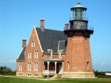
is located at the southeast corner of the island on the Mohegan Trail. The lighthouse was constructed in 1875 and remains to this day an active US Coast Guard
navigational aid. The lighthouse was moved in 1993, in danger of falling off the bluffs due to erosion. In addition to offering tours of the tower, the lighthouse has a museum that is open during the summer season.
The Mohegan Bluffs
are located a short distance to the west of Southeast Lighthouse
. The bluffs are the site of a pre-colonial battle between the invading Mohegan, and the native Niantic in which the Mohegan were driven off the edge of the tall cliffs to their deaths on the beach below. A long staircase of over one hundred stairs leads to the bottom of these clay cliffs and looks out over the Atlantic On clear days, Montauk, New York can be seen in the distance from the southern and western sides of the island.
Rodman's Hollow is a 230 acres (93.1 ha) glacial outwash basin, near the southern shore of the island. The hollow has several walking trails. Horseback rides through Rodman's Hollow are also offered.
North Lighthouse
is located at Sandy Point on the northern tip of Block Island. The North Lighthouse warns boaters of a sandbar extending from this end of the island. The surrounding dunes are part of the Block Island National Wildlife Refuge, home to many species, including the Piping Plover
and American Burying Beetle. A short walk away from the North Lighthouse lies the tip of the island, with ocean on both sides of a thin strip of land.
The Block Island Historical Society Museum is located near the downtown area and contains a broad array of Block Island artifacts.
U-853
is a U-boat
wreck 7 miles (11 km) east of the island, lying in 130 ft (40 m) of water. Recreational divers frequently visit the wreck, though at least three have died there.
, and in summer to New London, Connecticut
; Montauk, New York
; and Newport, Rhode Island
. The traditional ferry, takes about an hour to reach the island from Point Judith. A high-speed ferry on the same route takes 35 minutes. Another high-speed ferry from New London, Connecticut to Block Island takes an hour and a half. During the summer season, travelers wishing to bring their cars usually have to book reservations months in advance. New England Airlines
offers regularly scheduled 12-minute flights to Block Island State Airport
from Westerly, Rhode Island
.
liner RMS Queen Elizabeth 2
struck a submerged rock off Block Island.
in his 1867 poem, "The Wreck of the Palatine", among whose verses the words "Circled by waters that never freeze, Beaten by billow and swept by breeze, Lieth the island of Manisees", have become well-known. Two submarines also sank off of Block Island: the United States Navy USS S-51
in 1925, and the German U-Boat
U-853 in 1945. One shipwreck in particular sank in the 1800s just south of the southeast lighthouse. Its mast lies submerged approximately 4 feet below the water's surface. The area remains closed off to passing boats.
U.S. state
A U.S. state is any one of the 50 federated states of the United States of America that share sovereignty with the federal government. Because of this shared sovereignty, an American is a citizen both of the federal entity and of his or her state of domicile. Four states use the official title of...
of Rhode Island
Rhode Island
The state of Rhode Island and Providence Plantations, more commonly referred to as Rhode Island , is a state in the New England region of the United States. It is the smallest U.S. state by area...
and is located in the Atlantic Ocean approximately 13 miles (21 km) south of the coast of Rhode Island, 14 miles (23 km) east of Montauk Point on Long Island
Long Island
Long Island is an island located in the southeast part of the U.S. state of New York, just east of Manhattan. Stretching northeast into the Atlantic Ocean, Long Island contains four counties, two of which are boroughs of New York City , and two of which are mainly suburban...
, and is separated from the Rhode Island mainland by Block Island Sound
Block Island Sound
Block Island Sound is a strait in the open Atlantic Ocean, approximately wide, separating Block Island from the coast of Rhode Island in the United States...
. The United States Census Bureau
United States Census Bureau
The United States Census Bureau is the government agency that is responsible for the United States Census. It also gathers other national demographic and economic data...
defines Block Island as Census Tract
Census tract
A census tract, census area, or census district is a geographic region defined for the purpose of taking a census. Usually these coincide with the limits of cities, towns or other administrative areas and several tracts commonly exist within a county...
415 of Washington County, Rhode Island
Washington County, Rhode Island
Washington County, commonly known colloquially as South County, is a county located in the southwestern part of the U.S. state of Rhode Island. Washington County borders Kent County to the north, New London County in Connecticut to the west, Suffolk County in New York to the southwest, the Atlantic...
. As of the 2000 census
United States Census, 2000
The Twenty-second United States Census, known as Census 2000 and conducted by the Census Bureau, determined the resident population of the United States on April 1, 2000, to be 281,421,906, an increase of 13.2% over the 248,709,873 persons enumerated during the 1990 Census...
the population of 1,010 lived on a land area of 9.734 square miles (25.211 km²). The island is part of the Outer Lands
Outer Lands
The Outer Lands is a term denoting the prominent terminal moraine archipelagic region off the southern coast of New England in the United States...
region, a coastal archipelago made by the recessional and terminal moraine
Terminal moraine
A terminal moraine, also called end moraine, is a moraine that forms at the end of the glacier called the snout.Terminal moraines mark the maximum advance of the glacier. An end moraine is at the present boundary of the glacier....
that resulted from the Wisconsonian Laurentide glacier retreat
Wisconsin glaciation
The last glacial period was the most recent glacial period within the current ice age occurring during the last years of the Pleistocene, from approximately 110,000 to 10,000 years ago....
, about 22,000 years ago.
The Nature Conservancy
The Nature Conservancy
The Nature Conservancy is a US charitable environmental organization that works to preserve the plants, animals, and natural communities that represent the diversity of life on Earth by protecting the lands and waters they need to survive....
added Block Island to its list of "The Last Great Places." The list consists of twelve sites in the Western Hemisphere. Approximately 40 percent of the Island is set aside for conservation. Presidents Bill Clinton
Bill Clinton
William Jefferson "Bill" Clinton is an American politician who served as the 42nd President of the United States from 1993 to 2001. Inaugurated at age 46, he was the third-youngest president. He took office at the end of the Cold War, and was the first president of the baby boomer generation...
, Dwight D. Eisenhower
Dwight D. Eisenhower
Dwight David "Ike" Eisenhower was the 34th President of the United States, from 1953 until 1961. He was a five-star general in the United States Army...
, Franklin Delano Roosevelt, and Ulysses S. Grant
Ulysses S. Grant
Ulysses S. Grant was the 18th President of the United States as well as military commander during the Civil War and post-war Reconstruction periods. Under Grant's command, the Union Army defeated the Confederate military and ended the Confederate States of America...
have visited Block Island.
Block island is also referred to as New Shoreham, RI. The island is a popular summer tourist destination and is known for its bicycling, hiking, sailing, fishing, and beaches. Two historic lighthouses are present on the island: Block Island North Light
Block Island North Light
Block Island North Light , built in 1867, is a historic lighthouse on Block Island, Rhode Island .-History:The first light on the site was built in 1829. The current structure at Sandy Point is the fourth lighthouse built on the site and was made of granite and iron in 1867...
, on the northern tip of the island, and Block Island Southeast Light
Block Island Southeast Light
Block Island Southeast Light is a lighthouse located on the southeastern shore of Block Island, Rhode Island. The lighthouse signals sea traffic coming from the Atlantic Ocean into the waters of Block Island and Long Island Sound, and remains an active navigational aid to sea vessels. It was...
, on the southeast side of the island. Much of the northwest tip of the island is an undeveloped natural area and resting stop for birds along the Atlantic Flyway
Atlantic Flyway
The Atlantic Flyway is a bird migration route that generally follows the Atlantic Coast of North America and the Appalachian Mountains. The main endpoints of the flyway include the Canadian Maritimes and the region surrounding the Gulf of Mexico; the migration route tends to narrow considerably in...
.
Every summer the island hosts Block Island Race Week, a competitive, week-long sailboat race. On odd years, the event is held by the Storm Trysail Club, and on even years by the Block Island Race Week. Yachts compete in various classes, sailing courses in Block Island Sound, and circumnavigating the island.
Other popular events include the annual Fourth of July Parade and celebration. During these times the island's population can triple over the normal summer vacation crowd.
Native History
The NianticNiantic (tribe)
The Niantic, or in their own language, the Nehântick or Nehantucket were a tribe of New England Native Americans, who were living in Connecticut and Rhode Island during the early colonial period. Due to intrusions of the Pequot, the Niantic were divided into an eastern and western division...
, whose tribe eventually merged with the Narragansett
Narragansett (tribe)
The Narragansett tribe are an Algonquian Native American tribe from Rhode Island. In 1983 they regained federal recognition as the Narragansett Indian Tribe of Rhode Island. In 2009, the United States Supreme Court ruled against their request that the Department of Interior take land into trust...
people, called the island "Manisses" which means "little island of Manitou
Manitou
Manitou is a general term for spirit beings among many Algonquian Native American groups.Manitou may also refer to:- Geography :* Manitou, Manitoba, Canada* Manitou, Kentucky, USA* Manitou, Oklahoma, USA- Other uses :...
". Archaeological sites indicate these people lived largely by hunting deer
Deer
Deer are the ruminant mammals forming the family Cervidae. Species in the Cervidae family include white-tailed deer, elk, moose, red deer, reindeer, fallow deer, roe deer and chital. Male deer of all species and female reindeer grow and shed new antlers each year...
, catching fish
Fish
Fish are a paraphyletic group of organisms that consist of all gill-bearing aquatic vertebrate animals that lack limbs with digits. Included in this definition are the living hagfish, lampreys, and cartilaginous and bony fish, as well as various extinct related groups...
and shellfish
Shellfish
Shellfish is a culinary and fisheries term for exoskeleton-bearing aquatic invertebrates used as food, including various species of molluscs, crustaceans, and echinoderms. Although most kinds of shellfish are harvested from saltwater environments, some kinds are found only in freshwater...
, and growing corn
Maize
Maize known in many English-speaking countries as corn or mielie/mealie, is a grain domesticated by indigenous peoples in Mesoamerica in prehistoric times. The leafy stalk produces ears which contain seeds called kernels. Though technically a grain, maize kernels are used in cooking as a vegetable...
, beans, and squash. They migrated from forest to coastal areas to take advantage of seasonal resources. Artifacts found in the area suggest that American Indians inhabited the area as far back as 1300 BC. In 1662, natives on the island numbered somewhere from 1,200 to 1,500. By 1774, that number had been reduced to fifty-one.
Due to intrusions by the Pequot
Pequot
Pequot people are a tribe of Native Americans who, in the 17th century, inhabited much of what is now Connecticut. They were of the Algonquian language family. The Pequot War and Mystic massacre reduced the Pequot's sociopolitical influence in southern New England...
and Mohegan
Mohegan
The Mohegan tribe is an Algonquian-speaking tribe that lives in the eastern upper Thames River valley of Connecticut. Mohegan translates to "People of the Wolf". At the time of European contact, the Mohegan and Pequot were one people, historically living in the lower Connecticut region...
in the early 17th century, the Niantic were split into two divisions; the Western Niantic, who allied with the Pequot and Mohegan, and the Eastern Niantic, who allied with the Narragansett
Narragansett
Narragansett may refer to:*Narragansett , a Pennsylvania Railroad train*Narragansett , an Amtrak train*Narragansett **Narragansett land claim*Narragansett, Rhode Island, a town*Narragansett Bay*Narragansett...
.
In 1634, Western Niantic defended their tribe by killing John Stone, a renegade Boston
Boston
Boston is the capital of and largest city in Massachusetts, and is one of the oldest cities in the United States. The largest city in New England, Boston is regarded as the unofficial "Capital of New England" for its economic and cultural impact on the entire New England region. The city proper had...
man, who was known for stealing Pilgrim
Pilgrim
A pilgrim is a traveler who is on a journey to a holy place. Typically, this is a physical journeying to some place of special significance to the adherent of a particular religious belief system...
vessels, near the mouth of the Connecticut River
Connecticut River
The Connecticut River is the largest and longest river in New England, and also an American Heritage River. It flows roughly south, starting from the Fourth Connecticut Lake in New Hampshire. After flowing through the remaining Connecticut Lakes and Lake Francis, it defines the border between the...
. Despite the fact the man was trying to kidnap native women and children to sell as slaves in Virginia
Virginia
The Commonwealth of Virginia , is a U.S. state on the Atlantic Coast of the Southern United States. Virginia is nicknamed the "Old Dominion" and sometimes the "Mother of Presidents" after the eight U.S. presidents born there...
, the colonists became furious (partly due to earlier Indian atrocities against settlers on the mainland by a related tribe) . The English demanded that the Pequot Indians (who spoke for the Western Niantic) surrender his killers. This was refused and began the slide towards war. In the summer of 1637, the Western Niantic killed another Boston man, the trader John Oldham, near Block Island.
Without consulting the Connecticut
Connecticut
Connecticut is a state in the New England region of the northeastern United States. It is bordered by Rhode Island to the east, Massachusetts to the north, and the state of New York to the west and the south .Connecticut is named for the Connecticut River, the major U.S. river that approximately...
colonists, Massachusetts
Massachusetts Bay Colony
The Massachusetts Bay Colony was an English settlement on the east coast of North America in the 17th century, in New England, situated around the present-day cities of Salem and Boston. The territory administered by the colony included much of present-day central New England, including portions...
, in August, sent a punitive expedition of ninety men under John Endicott to Block Island with instructions to kill every Niantic warrior and capture the woman and children, who would be valuable as slaves. The expedition was ordered by Massachusetts Governor Henry Vane
Henry Vane the Younger
Sir Henry Vane , son of Henry Vane the Elder , was an English politician, statesman, and colonial governor...
to "massacre all of the Native men on the island". The expedition killed fourteen Eastern Niantic and burned their village and crops. The English burned sixty wigwam
Wigwam
A wigwam or wickiup is a domed room dwelling used by certain Native American tribes. The term wickiup is generally used to label these kinds of dwellings in American Southwest and West. Wigwam is usually applied to these structures in the American Northeast...
s and the corn fields. They also shot every dog, but the Niantic fled into the woods, and the soldiers only managed to kill fourteen of them. Deciding this punishment was insufficient, Endicott and his men sailed over to Fort Saybrook before going after the Pequot village at the mouth of the Thames River
Thames River (Connecticut)
The Thames River is a short river and tidal estuary in the U.S. state of Connecticut. It flows south for through eastern Connecticut from the junction of the Yantic and Shetucket rivers at Norwich, to New London and Groton, which flank its mouth at the Long Island Sound.Differing from its...
to demand one thousand fathom
Fathom
A fathom is a unit of length in the imperial and the U.S. customary systems, used especially for measuring the depth of water.There are 2 yards in an imperial or U.S. fathom...
s of wampum
Wampum
Wampum are traditional, sacred shell beads of the Eastern Woodlands tribes of the indigenous people of North America. Wampum include the white shell beads fashioned from the North Atlantic channeled whelk shell; and the white and purple beads made from the quahog, or Western North Atlantic...
to pay for the murder of John Oldham and some Pequot children as hostages to insure peace. This incident is seen as one of the initial events that led to the Pequot War
Pequot War
The Pequot War was an armed conflict between 1634–1638 between the Pequot tribe against an alliance of the Massachusetts Bay, Plymouth, and Saybrook colonies who were aided by their Native American allies . Hundreds were killed; hundreds more were captured and sold into slavery to the West Indies. ...
.
Colonial history to present
Louise of Savoy
Louise of Savoy was a French noble, Duchess regnant of Auvergne and Bourbon, Duchess of Nemours, the mother of King Francis I of France...
, the Queen Mother
Queen mother
Queen Mother is a title or position reserved for a widowed queen consort whose son or daughter from that marriage is the reigning monarch. The term has been used in English since at least 1577...
of France, and the mother of Francis I. However, several maps of the era named the island "Claudia", in honor of Claude, the wife of Francis I. Verrazano described Luisa (Claudia) as "about the size of the Island of Rhodes
Rhodes
Rhodes is an island in Greece, located in the eastern Aegean Sea. It is the largest of the Dodecanese islands in terms of both land area and population, with a population of 117,007, and also the island group's historical capital. Administratively the island forms a separate municipality within...
." In fact, they are shaped very similarly. When the founders of Colony of Rhode Island and Providence Plantations
Colony of Rhode Island and Providence Plantations
The Colony of Rhode Island and Providence Plantations was one of the original English Thirteen Colonies established on the east coast of North America that, after the American Revolution, became the modern U.S...
surveyed the land, they thought that Aquidneck Island
Aquidneck Island
Aquidneck Island, located in the state of Rhode Island, is the largest island in Narragansett Bay. The island's official name is Rhode Island, and the common use of name "Aquidneck Island" helps distinguish the island from the state. The total land area is 97.9 km²...
was the place referred to by Verrazano. In 1614, Block Island was charted by the Dutch
Netherlands
The Netherlands is a constituent country of the Kingdom of the Netherlands, located mainly in North-West Europe and with several islands in the Caribbean. Mainland Netherlands borders the North Sea to the north and west, Belgium to the south, and Germany to the east, and shares maritime borders...
explorer Adrian Block, who named it for himself. English settlers from the mainland first arrived in 1661 led by Captain John Underhill
Captain John Underhill
John Underhill was an early English settler and soldier in the Massachusetts Bay Colony, the Province of New Hampshire, the New Haven Colony, New Netherland, and later the Province of New York...
, when the island was part of the Massachusetts Bay Colony
Massachusetts Bay Colony
The Massachusetts Bay Colony was an English settlement on the east coast of North America in the 17th century, in New England, situated around the present-day cities of Salem and Boston. The territory administered by the colony included much of present-day central New England, including portions...
. The island became part of the colony of Rhode Island in 1672 and the island government adopted the name "New Shoreham". A Dutch map of 1685 clearly shows Block Island, indicated as Adrian Block Island ("Adriaen Blocks Eylant").
In 1699, the Scottish sailor William Kidd
William Kidd
William "Captain" Kidd was a Scottish sailor remembered for his trial and execution for piracy after returning from a voyage to the Indian Ocean. Some modern historians deem his piratical reputation unjust, as there is evidence that Kidd acted only as a privateer...
visited Block Island, shortly before he was accused of piracy and hanged. At Block Island he was supplied by Mrs. Mercy (Sands) Raymond, daughter of the mariner James Sands. The story has it that, for her hospitality, Mrs. Raymond was bid to hold out her apron, into which Kidd threw gold and jewels until it was full. After her husband Joshua Raymond died, Mercy moved with her family to northern New London, Connecticut
New London, Connecticut
New London is a seaport city and a port of entry on the northeast coast of the United States.It is located at the mouth of the Thames River in New London County, southeastern Connecticut....
(later Montville), where she bought much land. The Raymond family was thus said to have been "enriched by the apron".
During The War of 1812 Block Island was briefly occupied by the British Navy under the command of Sir Thomas Hardy. British vessels included HMS Dispatch
HMS Dispatch
Seventeen ships of the Royal Navy have borne the name HMS Dispatch, or the variant HMS Despatch: was a 2-gun brigantine launched in 1691 and sold in 1712. was a 14-gun sloop launched in 1745 and sold in 1763. was a 14-gun sloop that foundered in a hurricane in 1772. She may have been salved and...
, HMS Terror
HMS Terror (1813)
HMS Terror was a bomb vessel designed by Sir Henry Peake and constructed by the Royal Navy in the Davy shipyard in Topsham, Devon. The ship, variously listed as being of either 326 or 340 tons, carried two mortars, one and one .-War service:...
, HMS Nimrod
HMS Nimrod
Six ships of the Royal Navy have borne the name HMS Nimrod, after the biblical figure of Nimrod: was an 18-gun sloop, previously the French ship Eole. She was captured in 1799 by HMS Solebay and sold in 1811...
, HMS Pactolus
HMS Pactolus (1813)
HMS Pactolus was one of eight 38-gun Cydnus-class fifth-rate frigates of the Royal Navy, that served in the Napoleonic wars and the War of 1812. She was one of the warships that bombarded Stonington, Connecticut from 9 to 12 August 1814...
and HMS Ramillies
HMS Ramillies (1785)
HMS Ramillies was a 74-gun third rate ship of the line of the Royal Navy, launched on 12 July 1785 at Rotherhithe.In 1801, she was part of Admiral Sir Hyde Parker's reserve squadron at the Battle of Copenhagen, and so did not take an active part in the battle.In August 1812, Sir Thomas Masterman...
. Hardy took the fleet to Block Island in search of food and to establish a strategic position at the mouth of the Long Island Sound
Long Island Sound
Long Island Sound is an estuary of the Atlantic Ocean, located in the United States between Connecticut to the north and Long Island, New York to the south. The mouth of the Connecticut River at Old Saybrook, Connecticut, empties into the sound. On its western end the sound is bounded by the Bronx...
. The British were enraged to discover that virtually all Block Island livestock and food stores had been transferred to Stonington, Connecticut
Stonington, Connecticut
The Town of Stonington is located in New London County, Connecticut, in the state's southeastern corner. It includes the borough of Stonington, the villages of Pawcatuck, Lords Point, Wequetequock, the eastern halves of the villages of Mystic and Old Mystic...
in advance of their arrival. On August 9, 1814 Hardy and his fleet departed Block Island for Stonington Harbor in part to lay claim to the Block Island food stores and livestock. Hardy's pre-dawn raid on the 10th of August was repulsed with damage to his fleet in a battle that has since become known as The Battle of Stonington.
In 1829, the original North Lighthouse
Block Island North Light
Block Island North Light , built in 1867, is a historic lighthouse on Block Island, Rhode Island .-History:The first light on the site was built in 1829. The current structure at Sandy Point is the fourth lighthouse built on the site and was made of granite and iron in 1867...
was built, but it was replaced in 1837 after it was washed out to sea. This lighthouse was also claimed by the ocean. In 1867, the lighthouse that can be seen today was constructed. A few years later in 1873, construction began on Block Island's other lighthouse, Southeast Light
Block Island Southeast Light
Block Island Southeast Light is a lighthouse located on the southeastern shore of Block Island, Rhode Island. The lighthouse signals sea traffic coming from the Atlantic Ocean into the waters of Block Island and Long Island Sound, and remains an active navigational aid to sea vessels. It was...
.
Since Block Island has no natural harbors, breakwaters were constructed to form Old Harbor in 1870. Block Island's other harbor, New Harbor, wouldn't be created until 1895 when a channel was dug that connected the Great Salt Pond to the ocean through the north west side of the island.
The Island Free Library, Block Island's only public library
Public library
A public library is a library that is accessible by the public and is generally funded from public sources and operated by civil servants. There are five fundamental characteristics shared by public libraries...
, was established in 1875. Block Island's school was built in 1933, replacing five one roomed schools.
During World War II several artillery spotters were located on the island to direct fire from the heavy gun batteries at Fort Greene, Point Judith that protected the entrance to Narragansett Bay
Narragansett Bay
Narragansett Bay is a bay and estuary on the north side of Rhode Island Sound. Covering 147 mi2 , the Bay forms New England's largest estuary, which functions as an expansive natural harbor, and includes a small archipelago...
. Lookout positions for the spotters were built to look like houses. The US government offered to evacuate the island, as it could not be effectively defended from enemy invasion. However, the islanders chose to stay. Days before the war ended, the Battle of Point Judith took place 7 miles to the northeast of the island.
The island's airport
Block Island State Airport
Block Island State Airport is a public airport located on Block Island, in Washington County, Rhode Island, United States. The airport is owned by the State of Rhode Island. It is primarily a general aviation airport, but there is also scheduled airline service to Westerly State Airport...
was opened in 1950 and remains open today as a general aviation
General aviation
General aviation is one of the two categories of civil aviation. It refers to all flights other than military and scheduled airline and regular cargo flights, both private and commercial. General aviation flights range from gliders and powered parachutes to large, non-scheduled cargo jet flights...
airport. In 1972 the Block Island Conservancy was founded. The Conservancy and other environmental organizations are responsible for protecting over 40% of the island from development. In 1974 Old Harbor Historic District
Old Harbor Historic District
Old Harbor Historic District is a historic district roughly bounded by Atlantic Ocean and Main St. in New Shoreham, Rhode Island on Block Island....
was declared a National Register historic district. Discussions of Block Island's old buildings, native islanders, history, and ongoing efforts to conserve the land, together with a collection of 800 period photographs of the island spanning the 1870s to the 1980s, are found in four books: "Block Island --- The Sea", "Block Island --- The Land", and Volumes 1 & 2 of "The Block Island History of Photography", all by historian Robert M. Downie.
Climate
Block Island's weather is greatly influenced by the surrounding ocean and prevailing winds that generally blow offshore. The climate is oceanicOceanic climate
An oceanic climate, also called marine west coast climate, maritime climate, Cascadian climate and British climate for Köppen climate classification Cfb and subtropical highland for Köppen Cfb or Cwb, is a type of climate typically found along the west coasts at the middle latitudes of some of the...
(Koppen Cfb), a rarity on an east coast in the Northern Hemisphere. Because the ocean stays cold during the Spring and Summer months, Block Island stays cooler than the mainland during this period. However, summers can still be hot on Block Island although July and August average in the mid and upper 70s instead of low and mid 80s that New York and New England experience. Block Island's record high temperature is 95 °F (35 °C). Block Island stays warmer than the mainland during the fall and winter months when the ocean remains relatively warmer than the mainland. Block Island's record low is -7 °F.
Block Island's High and Low Temperature Averages and Precipitation Averages:
Beaches
Crescent Beach can be viewed from the Pt. Judith Ferry on the way to the island. It contains three smaller beaches, Fred Benson Town Beach (still popularly known as State Beach due to its former status as one), Scotch Beach, and Mansion Beach, all of which are located on Corn Neck Road. State Beach and Ballards Beach are the only beaches on the island with on-duty life guards. State Beach has a pavilion with food and beach rentals. The so-called Baby Beach begins at the Surf Hotel, near the Beachhead Restaurant on Corn Neck Rd. Scotch Beach is located just north of Fred Benson Town Beach and Mansion Beach is located north of Scotch Beach.North of Mansion Beach are Clayhead and Pots & Kettles. Clayhead is a set of cliffs which can be seen from the ferry in from Point Judith or New London. This area is rocky and contains iron-rich clay deposits, and is a popular area for shell and rock hunting.
Cow Cove, Settler's Rock, and Sandy Point make up the northernmost point of Block Island. Here lies the North Lighthouse and the postcard sunsets. Settler's Rock is located at Cow Cove, where the settlers landed and swam to shore bringing with them the island's first cows, which they pushed off the boats and forced ashore. Attached to the rock is a plaque naming the original settlers of Block Island. This beach is not ideal for swimming on the ocean side, especially at the point, due to strong rip current
Rip current
A rip current, commonly referred to by the misnomer rip tide, is a strong channel of water flowing seaward from near the shore, typically through the surf line. Typical flow is at 0.5 metres per second , and can be as fast as 2.5 metres per second...
s. On the other side, however, is Sachem Pond, fresh water and good for swimming.
On the south side of the island, Black Rock Beach is widely regarded as the best beach for surfing on the island due to its high surf. However, the beach tends to be very rocky and has a reputation for being a nude beach, despite laws against nudity on Rhode Island's beaches. It is located near the Mohegan Bluffs and Southeast Lighthouse.
Coastguard Beach is situated between the Great Salt Pond and the ocean on the north west side of the island. It is a popular beach for fishing and walking, but not particularly good for swimming due to the large number of boats traveling nearby.
Ballard's Beach is on the southern side of the Block Island Ferry Dock and jetty. Set right in front of Ballard's Restaurant and Inn, popular with boaters and with the young crowd. There are cocktail waitresses on the sand, and daily live music outside. There's also a busy volleyball court with daily games and tournaments. There are lifeguards on duty at Ballard's Beach.
Bluffs Beach is accessed by parking at the Mohegan Bluffs entrance and walking down the stairs. There are 141 steps to this rocky area, known for its spectacular view. At the foot of these steep wooden stairs are big rocks leading to the beach.
Tourist attractions
Southeast LighthouseBlock Island Southeast Light
Block Island Southeast Light is a lighthouse located on the southeastern shore of Block Island, Rhode Island. The lighthouse signals sea traffic coming from the Atlantic Ocean into the waters of Block Island and Long Island Sound, and remains an active navigational aid to sea vessels. It was...
is located at the southeast corner of the island on the Mohegan Trail. The lighthouse was constructed in 1875 and remains to this day an active US Coast Guard
United States Coast Guard
The United States Coast Guard is a branch of the United States Armed Forces and one of the seven U.S. uniformed services. The Coast Guard is a maritime, military, multi-mission service unique among the military branches for having a maritime law enforcement mission and a federal regulatory agency...
navigational aid. The lighthouse was moved in 1993, in danger of falling off the bluffs due to erosion. In addition to offering tours of the tower, the lighthouse has a museum that is open during the summer season.
The Mohegan Bluffs
The Mohegan Bluffs
The Mohegan Bluffs are large clay cliffs about high, located on the southern shore of Block Island. They got their name because the battle of the Niantic and the Mohegan took place here in the mid 16th century...
are located a short distance to the west of Southeast Lighthouse
Block Island Southeast Light
Block Island Southeast Light is a lighthouse located on the southeastern shore of Block Island, Rhode Island. The lighthouse signals sea traffic coming from the Atlantic Ocean into the waters of Block Island and Long Island Sound, and remains an active navigational aid to sea vessels. It was...
. The bluffs are the site of a pre-colonial battle between the invading Mohegan, and the native Niantic in which the Mohegan were driven off the edge of the tall cliffs to their deaths on the beach below. A long staircase of over one hundred stairs leads to the bottom of these clay cliffs and looks out over the Atlantic On clear days, Montauk, New York can be seen in the distance from the southern and western sides of the island.
Rodman's Hollow is a 230 acres (93.1 ha) glacial outwash basin, near the southern shore of the island. The hollow has several walking trails. Horseback rides through Rodman's Hollow are also offered.
North Lighthouse
Block Island North Light
Block Island North Light , built in 1867, is a historic lighthouse on Block Island, Rhode Island .-History:The first light on the site was built in 1829. The current structure at Sandy Point is the fourth lighthouse built on the site and was made of granite and iron in 1867...
is located at Sandy Point on the northern tip of Block Island. The North Lighthouse warns boaters of a sandbar extending from this end of the island. The surrounding dunes are part of the Block Island National Wildlife Refuge, home to many species, including the Piping Plover
Piping Plover
The Piping Plover is a small sand-colored, sparrow-sized shorebird that nests and feeds along coastal sand and gravel beaches in North America. The adult has yellow-orange legs, a black band across the forehead from eye to eye, and a black ring around the neck...
and American Burying Beetle. A short walk away from the North Lighthouse lies the tip of the island, with ocean on both sides of a thin strip of land.
The Block Island Historical Society Museum is located near the downtown area and contains a broad array of Block Island artifacts.
U-853
Unterseeboot 853
German submarine U-853 was a German Type IXC/40 U-boat of the Kriegsmarine during World War II. Her keel was laid down on 21 August 1942 by AG Weser of Bremen. She was commissioned on 25 June 1943 with Kapitänleutnant Helmut Sommer in command. U-853 saw action during the Battle of the Atlantic in...
is a U-boat
U-boat
U-boat is the anglicized version of the German word U-Boot , itself an abbreviation of Unterseeboot , and refers to military submarines operated by Germany, particularly in World War I and World War II...
wreck 7 miles (11 km) east of the island, lying in 130 ft (40 m) of water. Recreational divers frequently visit the wreck, though at least three have died there.
Transportation
The island is connected year-round by a ferry to Point JudithPoint Judith
Point Judith is a village and a small cape, on the coast of Narragansett, Rhode Island, on the western side of Narragansett Bay where it opens out onto Rhode Island Sound....
, and in summer to New London, Connecticut
New London, Connecticut
New London is a seaport city and a port of entry on the northeast coast of the United States.It is located at the mouth of the Thames River in New London County, southeastern Connecticut....
; Montauk, New York
Montauk, New York
Montauk [ˈmɒntɒk] is a census-designated place that roughly corresponds to the hamlet with the same name located in the town of East Hampton in Suffolk County, New York, United States on the South Shore of Long Island. As of the United States 2000 Census, the CDP population was 3,851 as of 2000...
; and Newport, Rhode Island
Newport, Rhode Island
Newport is a city on Aquidneck Island in Newport County, Rhode Island, United States, about south of Providence. Known as a New England summer resort and for the famous Newport Mansions, it is the home of Salve Regina University and Naval Station Newport which houses the United States Naval War...
. The traditional ferry, takes about an hour to reach the island from Point Judith. A high-speed ferry on the same route takes 35 minutes. Another high-speed ferry from New London, Connecticut to Block Island takes an hour and a half. During the summer season, travelers wishing to bring their cars usually have to book reservations months in advance. New England Airlines
New England Airlines
New England Airlines is a regional airline based in Westerly, Rhode Island, USA. With a main base at Westerly State Airport, it provides scheduled service to Block Island and operates charters to other destinations.- History :...
offers regularly scheduled 12-minute flights to Block Island State Airport
Block Island State Airport
Block Island State Airport is a public airport located on Block Island, in Washington County, Rhode Island, United States. The airport is owned by the State of Rhode Island. It is primarily a general aviation airport, but there is also scheduled airline service to Westerly State Airport...
from Westerly, Rhode Island
Westerly (town), Rhode Island
Westerly is a town on the southwestern shoreline of Washington County, Rhode Island, United States. Founded in 1669 by John Babcock, it is a beachfront community on the south shore of the state. The population was 22,787 at the 2010 census...
.
Incidents
In 1992 the CunardCunard Line
Cunard Line is a British-American owned shipping company based at Carnival House in Southampton, England and operated by Carnival UK. It has been a leading operator of passenger ships on the North Atlantic for over a century...
liner RMS Queen Elizabeth 2
RMS Queen Elizabeth 2
Queen Elizabeth 2, often referred to simply as the QE2, is an ocean liner that was operated by Cunard from 1969 to 2008. Following her retirement from cruising, she is now owned by Istithmar...
struck a submerged rock off Block Island.
Shipwrecks
The area around Block Island has been the site of numerous shipwrecks, including the Steamer Larchmont in 1907 http://query.nytimes.com/gst/abstract.html?res=9D00EED6153EE033A25750C1A9649C946697D6CF. The 1738 wreck of the Princess Augusta (also known as the Palatine ship) was later immortalized by John Greenleaf WhittierJohn Greenleaf Whittier
John Greenleaf Whittier was an influential American Quaker poet and ardent advocate of the abolition of slavery in the United States. He is usually listed as one of the Fireside Poets...
in his 1867 poem, "The Wreck of the Palatine", among whose verses the words "Circled by waters that never freeze, Beaten by billow and swept by breeze, Lieth the island of Manisees", have become well-known. Two submarines also sank off of Block Island: the United States Navy USS S-51
USS S-51 (SS-162)
USS S-51 was a fourth-group S-class submarine of the United States Navy.Her keel was laid down on 22 December 1919 by the Lake Torpedo Boat Company of Bridgeport, Connecticut. She was launched on 20 August 1921 sponsored by Mrs. R.J. Mills, and commissioned on 24 June 1922 with Lieutenant W. S...
in 1925, and the German U-Boat
U-boat
U-boat is the anglicized version of the German word U-Boot , itself an abbreviation of Unterseeboot , and refers to military submarines operated by Germany, particularly in World War I and World War II...
U-853 in 1945. One shipwreck in particular sank in the 1800s just south of the southeast lighthouse. Its mast lies submerged approximately 4 feet below the water's surface. The area remains closed off to passing boats.
Notable residents
Notable current and former residents of Block Island include:- Kenneth BaconKenneth BaconKenneth Hogate Bacon was an American journalist who served as a spokesman for the Department of Defense during the Presidency of Bill Clinton, and later as president of Refugees International, an organization dedicated to advocating for assistance and protection for displaced persons and promoting...
(1944–2009), Department of DefenseUnited States Department of DefenseThe United States Department of Defense is the U.S...
spokesman who later served as president of Refugees InternationalRefugees InternationalRefugees International is a humanitarian organization supporting refugees and stateless people. It publishes annual reports, as well as approximately twenty-five field reports throughout the year on refugee issues, as well as comments on international aid issues around the world...
. - Jens RisomJens RisomJens Risom is a Danish American furniture designer. An exemplar of Mid-Century modern design, Risom was one of the first designers to introduce Scandinavian design in the United States. Note: "Jens" is pronounced "Yenns", and almost rhymes with "fence".-Biography:Jens Risom was born in...
(1916 - ) Danish-American furniture designer - Christopher WalkenChristopher WalkenChristopher Walken is an American stage and screen actor. He has appeared in more than 100 movies and television shows, including Joe Dirt, Annie Hall, The Deer Hunter, The Prophecy trilogy, The Dogs of War, Sleepy Hollow, Brainstorm, The Dead Zone, A View to a Kill, At Close Range, King of New...
(1943—) American actor