

Stikine Country
Encyclopedia
Provinces and territories of Canada
The provinces and territories of Canada combine to make up the world's second-largest country by area. There are ten provinces and three territories...
of British Columbia
British Columbia
British Columbia is the westernmost of Canada's provinces and is known for its natural beauty, as reflected in its Latin motto, Splendor sine occasu . Its name was chosen by Queen Victoria in 1858...
, located inland from the central Alaska Panhandle
Alaska Panhandle
Southeast Alaska, sometimes referred to as the Alaska Panhandle, is the southeastern portion of the U.S. state of Alaska, which lies west of the northern half of the Canadian province of British Columbia. The majority of Southeast Alaska's area is part of the Tongass National Forest, the United...
and comprising the basin of the Stikine River
Stikine River
The Stikine River is a river, historically also the Stickeen River, approximately 610 km long, in northwestern British Columbia in Canada and southeastern Alaska in the United States...
and its tributaries. The term Stikine-Iskut (alone or in various combination forms "District", "Country", "Region") is also fairly common to describe the area, and references the Iskut River
Iskut River
The Iskut River is the largest tributary of the Stikine River in northwestern British Columbia, Canada, entering it a few miles above its entry into Alaska....
, the Stikine's largest tributary and describable as its south fork.
Geography
The basin of the Stikine is sparsely populated, mostly by members of the TahltanTahltan
Tahltan refers to a Northern Athabaskan people who live in northern British Columbia around Telegraph Creek, Dease Lake, and Iskut.-Social Organization:...
people, though the lower reaches are the territory of group of the Tlingit people centred on Wrangell, Alaska
Wrangell, Alaska
Wrangell is a city and borough in the U.S. state of Alaska. At the 2000 census the population was 2,308.Its Tlingit name is Ḵaachx̱aana.áakʼw . The Tlingit people residing in the Wrangell area, who were there centuries before Europeans, call themselves the Shtaxʼhéen Ḵwáan after the nearby Stikine...
, which is on Etolin Island
Etolin Island
Etolin Island is an island in the Alexander Archipelago of southeastern Alaska, USA, at . It is between Prince of Wales Island, to its west, and the Alaska mainland, to its east. It is southwest of Wrangell Island. It was first charted in 1793 by James Johnstone, one of George Vancouver's...
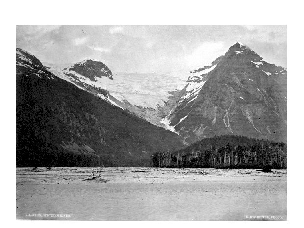
just outside the mouht of the Stikine. The region is noted for its rugged and unusual mix of glaciated ranges, semi-arid subarctic volcanic plateaux and cones, and deep river canyons, most of all the Grand Canyon of the Stikine
Grand Canyon of the Stikine
The Grand Canyon of the Stikine is a 45 mile stretch of the Stikine River in northern British Columbia, Canada. It has been compared to the Grand Canyon of the Colorado in scale and was called the "Yosemite of the North" by naturalist John Muir. The canyon is home to a large population of...
, which was described by naturalist John Muir
John Muir
John Muir was a Scottish-born American naturalist, author, and early advocate of preservation of wilderness in the United States. His letters, essays, and books telling of his adventures in nature, especially in the Sierra Nevada mountains of California, have been read by millions...
as "the northern Yosemite". Also notable and rather famous on the river's course is the Great Glacier, which fronts along the river's right (west) bank a few miles north of the Alaska frontier.
Mount Edziza Provincial Park, Spatsizi Plateau Wilderness Provincial Park
Spatsizi Plateau Wilderness Provincial Park
Spatsizi Plateau Wilderness Provincial Park is a provincial park in British Columbia, Canada, protecting most of the Spatsizi Plateau, the southeasternmost subplateau of the Stikine Plateau, and the upper reaches of the basin of the Stikine River.-History:...
and Stikine River Provincial Park
Stikine River Provincial Park
The Stikine River Provincial Park is a provincial park in British Columbia. The park covers a total area of approximately 217,000 hectares. The main feature of the Stikine River Provincial Park is a portion of the Stikine River known as "The Grand Canyon"...
are the largest provincial parks in the region, which continues to be heavily explored for mineral potentials since first opened up by the Stikine Gold Rush
Stikine Gold Rush
The Stikine Gold Rush was a minor but important gold rush in the Stikine Country of northwestern British Columbia, Canada. The rush's discoverer was Alexander "Buck" Choquette, who staked a claim at Choquette Bar in 1861, just downstream from the confluence of the Stikine and Anuk Rivers, at...
of the 1860s, which forced the creation of the Stikine Territory
Stikine Territory
The Stickeen Territories , also colloquially rendered as Stickeen Territory, Stikine Territory, and Stikeen Territory, was a territory of British North America whose brief existence began July 19, 1862, and concluded July of the following year. The region was split from the North-Western...
, soon afterwards absorbed into the Colony of British Columbia
Colony of British Columbia
The Colony of British Columbia was a crown colony in British North America from 1858 until 1866. At its creation, it physically constituted approximately half the present day Canadian province of British Columbia, since it did not include the Colony of Vancouver Island, the vast and still largely...
. The term "Stikine District" was also used in reference to the Stikine Mining District, an administrative jurisdiction. Today the term Stikine Region
Stikine Region
The Stikine Region is an unincorporated area in northwesternmost British Columbia, Canada and is the only area in B.C. not in a regional district...
is a British Columbia administrative district, similar to a Regional District
Regional districts of British Columbia
The Canadian province of British Columbia is divided into regional districts. Like counties in other parts of Canada, regional districts serve only to provide municipal services as the local government in areas not incorporated into a municipality, and in certain regional affairs of shared concern...
but not fully qualified as one, but it does not include all of the Stikine Country and comprises mostly the Cassiar Country
Cassiar Country
The Cassiar Country, also referred to simply as the Cassiar, is one of the historical geographic regions of the Canadian province of British Columbia...
and Atlin District
Atlin District
The Atlin District, also known as the Atlin Country, is a historical region located in the far northwestern corner of the Canadian province of British Columbia, centred on Atlin Lake and the gold-rush capital of the region, the town of Atlin...
, which are to the north and northwest of the Stikine Country, respectively.
The largest town in the district is Telegraph Creek
Telegraph Creek, British Columbia
Telegraph Creek is a small community located off Highway 37 in Northern British Columbia at the confluence of the Stikine River and Telegraph Creek. The only permanent settlement on the Stikine River, it is home to approximately 350 members of the Tahltan First Nation, as well as another 50...
, which lies on a side-road to the west of the Stewart-Cassiar Highway, which traverses the region from north to south, connecting parts of British Columbia farther south with the Yukon Territory to the north. To the northeast of the Stikine Country is another region known as the Cassiar Country
Cassiar Country
The Cassiar Country, also referred to simply as the Cassiar, is one of the historical geographic regions of the Canadian province of British Columbia...
, and to its southeast is the Omineca Country
Omineca Country
The Omineca Country, also called the Omineca District or the Omineca, is a historical geographic region of the Northern Interior of British Columbia, roughly defined by the basin of the Omineca River but including areas to the south which allowed access to the region during the Omineca Gold Rush of...
(both of which had also at one time been "Mining Districts" resulting from their own gold rushes).
History
The region was the traditional home of the TakuTaku people
The Taku are an Alaskan Native people, a ḵwáan or geographic subdivision of the Tlingit, known in their own language as the Tʼaaḵu Ḵwáan or "Geese Flood Upriver Tribe"...
and Inland Tlingit people who by the 19th century settled around what was to become the gold rush town of Atlin
Atlin, British Columbia
Atlin is a community in northwestern British Columbia, Canada, located on the eastern shore of Atlin Lake. In addition to continued gold-mining activity, Atlin is a tourist destination for fishing, hiking and Heliskiing. As of 2004, there are 450 permanent residents.The name comes from Áa Tlein,...
. Other First Nations
First Nations
First Nations is a term that collectively refers to various Aboriginal peoples in Canada who are neither Inuit nor Métis. There are currently over 630 recognised First Nations governments or bands spread across Canada, roughly half of which are in the provinces of Ontario and British Columbia. The...
such as the Tahltan settled at Telegraph Creek and Dease Lake. The Sekani
Sekani
Sekani is the name of an Athabaskan First Nations people in the Northern Interior of British Columbia. Their territory includes the Finlay and Parsnip River drainages of the Rocky Mountain Trench. The neighbors of the Sekani are the Babine to the west, Dakelh to the south, Dunneza to the east, and...
lived along the Finlay
Finlay River
The Finlay River is a 402 km long river in north-central British Columbia flowing north and thence south from Thutade Lake in the Omineca Mountains to Williston Lake, the impounded waters of the Peace River formed by the completion of the W.A.C. Bennett Dam in 1968. Prior to this, the Finlay...
and Parsnip River
Parsnip River
The Parsnip River is a 240 km long river in central British Columbia, Canada. It flows generally north-westward from the Parsnip Glacier in the Hart Ranges to the Parsnip Reach of Williston Lake, formed by the impounding of the waters of the Peace River by the W.A.C. Bennett Dam in 1968...
s, while in the east the Kaska
Kaska
The Kaska or Kaska Dena are a First Nations people living mainly in northern British Columbia and the southeastern Yukon in Canada. The Kaska language originally spoken by the Kaska is an Athabaskan language....
people occupied the Liard
Liard River
The Liard River flows through Yukon, British Columbia and the Northwest Territories, Canada. Rising in the Saint Cyr Range of the Pelly Mountains in southeastern Yukon, it flows southeast through British Columbia, marking the northern end of the Rocky Mountains and then curving northeast back...
and Dease River
Dease River
The Dease River flows through northwestern British Columbia, Canada and is a tributary of the Liard River. The river descends from Dease Lake, though its ultimate origin is in the headwater of Little Dease Creek at Snow Peak, approximately 50 km to the west of the lake...
s and eventually settled along McDame Creek
McDame Creek
McDame Creek is a creek located in the Cassiar Land District of British Columbia. The creek flows southeast into Dease River and is south of Good Hope Lake. The creek was discovered in 1874 by a prospector named Henry McDame. McDame Creek was mined for gold in the 1800s...
. Non native exploration of the district did not occur until the 1770’s with the arrival of Russian
Russians
The Russian people are an East Slavic ethnic group native to Russia, speaking the Russian language and primarily living in Russia and neighboring countries....
fur traders, who never traveled beyond the coastal areas, but relied on the Tlingits to provide the pelts from the inland animals. With the construction of a fort at Fort Wrangell
Wrangell, Alaska
Wrangell is a city and borough in the U.S. state of Alaska. At the 2000 census the population was 2,308.Its Tlingit name is Ḵaachx̱aana.áakʼw . The Tlingit people residing in the Wrangell area, who were there centuries before Europeans, call themselves the Shtaxʼhéen Ḵwáan after the nearby Stikine...
, the Russian fur traders held a monopoly in the region until the 1830’s when Fort Taku and Fort Stikine
Fort Stikine
Fort Stikine was a fur trade post and fortification in what is now the Alaska Panhandle, at the site of the present-day of Wrangell, Alaska, United States...
were both built on the Stikine River by the Hudson's Bay Company
Hudson's Bay Company
The Hudson's Bay Company , abbreviated HBC, or "The Bay" is the oldest commercial corporation in North America and one of the oldest in the world. A fur trading business for much of its existence, today Hudson's Bay Company owns and operates retail stores throughout Canada...
.
Stikine Gold Rush
On September 12, 1861, the VictoriaVictoria, British Columbia
Victoria is the capital city of British Columbia, Canada and is located on the southern tip of Vancouver Island off Canada's Pacific coast. The city has a population of about 78,000 within the metropolitan area of Greater Victoria, which has a population of 360,063, the 15th most populous Canadian...
newspaper, the British Colonist, reported a rumor that gold had been discovered on the Stikine River, and by the following spring, more than 200 miners struck out for the Cassiar. Sixty of them went on a sternwheeler, the Flying Dutchman, owned by Captain William Moore
William Moore (steamship captain)
William Moore was a steamship captain, businessman, miner and explorer in British Columbia and Alaska. During most of British Columbia's gold rushes Moore could be found at the center of activity, either providing transportation to the miners, working claims or delivering mail and...
.
While the rush did not settle the area, as had the Fraser Canyon
Fraser Canyon Gold Rush
The Fraser Canyon Gold Rush, began in 1858 after gold was discovered on the Thompson River in British Columbia at its confluence with the Nicoamen River. This was a few miles upstream from the Thompson's confluence with the Fraser River at present-day Lytton...
or the Cariboo Gold Rush
Cariboo Gold Rush
The Cariboo Gold Rush was a gold rush in the Canadian province of British Columbia. Although the first gold discovery was made in 1859 at Horsefly Creek, followed by more strikes at Keithley Creek and Antler Horns lake in 1860, the actual rush did not begin until 1861, when these discoveries were...
in their respective regions, it did draw the attention of British Columbia’s Governor James Douglas
James Douglas (Governor)
Sir James Douglas KCB was a company fur-trader and a British colonial governor on Vancouver Island in northwestern North America, particularly in what is now British Columbia. Douglas worked for the North West Company, and later for the Hudson's Bay Company becoming a high-ranking company officer...
, who petitioned the British government to create the Stikine Territory from the line of the Finlay and Skeena Rivers, which were the Colony of British Columbia's northern boundary, north to the 62nd parallel
62nd parallel north
The 62nd parallel north is a circle of latitude that is 62 degrees north of the Earth's equatorial plane. It crosses the Atlantic Ocean, Europe, Asia and North America....
and east to the 125th meridian
125th meridian west
The meridian 125° west of Greenwich is a line of longitude that extends from the North Pole across the Arctic Ocean, North America, the Pacific Ocean, the Southern Ocean, and Antarctica to the South Pole....
. The territory was established in 1862, and a year later it was merged into the Colony of British Columbia
Colony of British Columbia
The Colony of British Columbia was a crown colony in British North America from 1858 until 1866. At its creation, it physically constituted approximately half the present day Canadian province of British Columbia, since it did not include the Colony of Vancouver Island, the vast and still largely...
.
Collins Telegraph Line
In the early 1860’s, Perry CollinsPerry Collins
Perry McDonough Collins was the visionary behind the Russian American Telegraph of 1865-1867. The failed venture aimed to connect America to Europe by telegraph via the Bering Strait.-The early years:...
, obtained financing from Western Union Telegraph
Western Union
The Western Union Company is a financial services and communications company based in the United States. Its North American headquarters is in Englewood, Colorado. Up until 2006, Western Union was the best-known U.S...
to build a telegraph line from San Francisco through British Columbia and Alaska
Alaska
Alaska is the largest state in the United States by area. It is situated in the northwest extremity of the North American continent, with Canada to the east, the Arctic Ocean to the north, and the Pacific Ocean to the west and south, with Russia further west across the Bering Strait...
and across the Bering Strait
Bering Strait
The Bering Strait , known to natives as Imakpik, is a sea strait between Cape Dezhnev, Chukotka Autonomous Okrug, Russia, the easternmost point of the Asian continent and Cape Prince of Wales, Alaska, USA, the westernmost point of the North American continent, with latitude of about 65°40'N,...
to Russia
Russia
Russia or , officially known as both Russia and the Russian Federation , is a country in northern Eurasia. It is a federal semi-presidential republic, comprising 83 federal subjects...
and ultimately Europe
Europe
Europe is, by convention, one of the world's seven continents. Comprising the westernmost peninsula of Eurasia, Europe is generally 'divided' from Asia to its east by the watershed divides of the Ural and Caucasus Mountains, the Ural River, the Caspian and Black Seas, and the waterways connecting...
. The line was begun in 1865 at New Westminster
New Westminster, British Columbia
New Westminster is an historically important city in the Lower Mainland region of British Columbia, Canada, and is a member municipality of the Greater Vancouver Regional District. It was founded as the capital of the Colony of British Columbia ....
, and continued as far as the Skeena River
Skeena River
The Skeena River is the second longest river entirely within British Columbia, Canada . The Skeena is an important transportation artery, particularly for the Tsimshian and the Gitxsan - whose names mean "inside the Skeena River" and "people of the Skeena River" respectively, and also during the...
in 1866, but then the project was abandoned because the transatlantic line was built first, making the Collins line redundant. Despite the fact that the line would not be completed, surveyors had created a primitive route from Quesnel
Quesnel, British Columbia
-Demographics:Quesnel had a population of 9,326 people in 2006, which was a decrease of 7.1% from the 2001 census count. The median household income in 2005 for Quesnel was $54,044, which is slightly above the British Columbia provincial average of $52,709....
to the newly established settlement of Telegraph Creek, thus opening up the district for travel.
The region was also affected by the Klondike Gold Rush
Klondike Gold Rush
The Klondike Gold Rush, also called the Yukon Gold Rush, the Alaska Gold Rush and the Last Great Gold Rush, was an attempt by an estimated 100,000 people to travel to the Klondike region the Yukon in north-western Canada between 1897 and 1899 in the hope of successfully prospecting for gold...
when in 1897-1898, 5000 miners went to the Yukon
Yukon
Yukon is the westernmost and smallest of Canada's three federal territories. It was named after the Yukon River. The word Yukon means "Great River" in Gwich’in....
via the all Canadian route, up the Stikine River to Telegraph Creek and overland to the Teslin River
Teslin River
The Teslin River is a river in southern Yukon Territory and northwestern British Columbia, Canada, that flows 393 miles from its source south of Teslin Lake to its confluence with the Yukon River....
.
See also
- Stikine TerritoryStikine TerritoryThe Stickeen Territories , also colloquially rendered as Stickeen Territory, Stikine Territory, and Stikeen Territory, was a territory of British North America whose brief existence began July 19, 1862, and concluded July of the following year. The region was split from the North-Western...
- Northern Cordilleran Volcanic ProvinceNorthern Cordilleran volcanic provinceThe Northern Cordilleran Volcanic Province , formerly known as the Stikine Volcanic Belt, is a geologic province defined by the occurrence of Miocene to Holocene volcanoes in the Pacific Northwest of North America...
- Stikine Gold RushStikine Gold RushThe Stikine Gold Rush was a minor but important gold rush in the Stikine Country of northwestern British Columbia, Canada. The rush's discoverer was Alexander "Buck" Choquette, who staked a claim at Choquette Bar in 1861, just downstream from the confluence of the Stikine and Anuk Rivers, at...
- Stikine RiverStikine RiverThe Stikine River is a river, historically also the Stickeen River, approximately 610 km long, in northwestern British Columbia in Canada and southeastern Alaska in the United States...
- Stikine RangesStikine RangesThe Stikine Ranges are a mountain range in northwestern British Columbia, Canada. They are the northernmost subdivision of the Cassiar Mountains and among the least explored and most undeveloped parts of the province.-Sub-ranges:*Beady Range...
- Cassiar Gold Rush
- Omineca Gold RushOmineca Gold RushThe Omineca Gold Rush was a gold rush in British Columbia, Canada in the Omineca region of the Northern Interior of the province. Gold was first discovered there in 1861, but the rush didn't begin until late in 1869 with the discovery at Vital Creek....
- Fort StikineFort StikineFort Stikine was a fur trade post and fortification in what is now the Alaska Panhandle, at the site of the present-day of Wrangell, Alaska, United States...