
February 2009 Victorian bushfires
Encyclopedia
The Black Saturday bushfires were a series of bushfires that ignited or were burning across the Australia
n state of Victoria
on and around Saturday, 7 February 2009. The fires occurred during extreme bushfire-weather conditions, and resulted in Australia's highest ever loss of life from a bushfire; 173 people died and 414 were injured as a result of the fires.
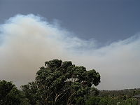
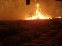
As many as 400 individual fires were recorded on 7 February. Following the events of 7 February 2009 and its aftermath, that day has become widely referred to as Black Saturday.
s in excess of 100 km/h (62.1 mph), precipitated by an intense heat wave, and almost two months of little or no rain, fanned the fires over large distances and areas. This created several large firestorms and pyrocumulus systems
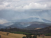
, particularly northeast of Melbourne, where a single firestorm accounted for 120 of the 173 deaths. A cool change hit the state in the early evening, bringing with it gale-force southwesterly winds in excess of 120 km/h (74.6 mph). This change in wind direction caused the long eastern flanks of the fires to become massive fire fronts that burned with incredible speed and ferocity towards towns that had earlier escaped the fires.
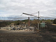
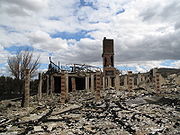
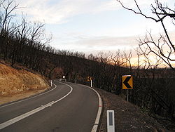
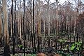
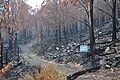
The fires destroyed over 2,030 houses and more than 3,500 structures in total, as well as damaging thousands more. Many towns northeast of the state capital Melbourne
were badly damaged or almost completely destroyed, including Kinglake
, Marysville
, Narbethong
, Strathewen
, and Flowerdale
. Many houses in the towns of Steels Creek
, Humevale
, Clonbinane
, Wandong
, St Andrews, Callignee
, Taggerty
, and Koornalla were also destroyed or severely damaged, with several fatalities recorded at each location.
The fires affected 78 individual townships in total, and displaced an estimated 7,562 people. Many of those displaced sought temporary accommodation, much of it donated in the form of spare rooms, caravans, tents, and beds in community relief centres.
power lines, or were deliberately lit
. Other suspected ignition sources included lightning
, cigarette butts, and sparks from a power tool. Also implicated in the underlying conditions was a major drought
that had persisted for more than a decade, as well as a domestic warming trend that has been linked to human-induced climate change
. By early to mid-March, favourable conditions aided containment efforts, and helped to extinguish the fires.
.png) A week before the fires, an exceptional heatwave affected southeastern Australia. From 28–30 January, Melbourne
A week before the fires, an exceptional heatwave affected southeastern Australia. From 28–30 January, Melbourne
broke records by sweltering through three consecutive days above 43 °C (109.4 °F), with the temperature peaking at 45.1 °C (113.2 °F) on 30 January, the third hottest day in the city's history.
The heatwave was caused by a slow moving high-pressure system
that settled over the Tasman Sea
, with a combination of an intense tropical low
located off the North West Australia
n coast and a monsoon trough
over northern Australia
, which produced ideal conditions for hot tropical air to be directed down over southeastern Australia.
The February fires commenced on a day when several localities across the state, including Melbourne
, recorded their highest temperatures since records began in 1859. On 6 February 2009—the day before the fires started—the Premier of Victoria John Brumby
issued a warning about the extreme weather conditions expected on 7 February: "It's just as bad a day as you can imagine and on top of that the state is just tinder-dry. People need to exercise real common sense tomorrow". The Premier went on to state that it was expected to be the "worst day [of fire conditions] in the history of the state".
 A total of 3,582 firefighting personnel, mainly from the Country Fire Authority (CFA)
and Department of Sustainability and Environment (DSE), were deployed across the state on the morning of 7 February in anticipation of the extreme conditions. By mid-morning, hot northwesterly winds in excess of 100 kilometres per hour (62.1 mph) hit the state, accompanied by extremely high temperatures and extremely low humidity. Also a total fire ban for the entire state was declared.
As the day progressed, all-time record temperatures were being reached. Melbourne hit 46.4 °C (115.5 °F), the hottest temperature ever recorded in an Australian capital city, and humidity levels dropped to as low as six percent. The McArthur Forest Fire Danger Index
reached unprecedented levels, ranging from 120 to over 200. This was higher than the fire weather conditions experienced on Black Friday
in 1939 and Ash Wednesday
in 1983.
By midday wind speeds were reaching their peak, and by 12:30 pm powerlines were felled in Kilmore East by the high winds. These sparked a bushfire that would later generate extensive pyrocumulus clouds, and become the largest, deadliest, and most intense firestorm ever experienced in Australia's post-European history. The overwhelming majority of fire activity occurred between midday and 7:00 pm, when wind speed and temperature were at their highest, and humidity at its lowest.
 Wednesday, 28 January 2009
Wednesday, 4 February
Saturday, 7 February (Black Saturday)
Sunday, 8 February
 Tuesday, 10 February
Tuesday, 17 February
Thursday, 19 February
Monday, 23 February
Friday, 27 February
Tuesday, 3 March 2009:
Wednesday, 4 March
Mid-March
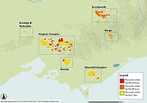
 The Kinglake
fire complex was named after two earlier fires, the Kilmore East
fire and the Murrindindi
Mill fire, merged following the wind change on the evening of 7 February. The complex was the largest of the many fires burning on Black Saturday, ultimately destroying over 330000 ha (815,447 acre). It was also the most destructive, with over 1,800 houses destroyed and 159 lives lost in the region.
in Kilmore East, sparking a fire in open grasslands that adjoined pine plantations. The fire was fanned by extreme northwesterly winds, and travelled 50 km (31.1 mi) southeast in a narrow fire front through Wandong
and Clonbinane
, into Kinglake National Park
, and then onto the towns of Humevale
, Kinglake West
, Strathewen
and St Andrews.
The cool change passed through the area around 5:30 pm, bringing strong southwesterly winds. The wind change turned the initial long and narrow fire band into a wide firefront that moved in a northeast direction through Kinglake
, Steels Creek
, Chum Creek
, Toolangi, Hazeldene
, and Flowerdale
.
The area become the worst impacted in the state, with a total of 120 deaths and more than 1,200 homes destroyed.
 According to eyewitnesses, the Murrindindi Mill fire started at 2:55 pm, while Victoria Police twice told the Royal Commission that it commenced at "about 2.30 pm". It burned southeast across the Black Range, parallel to the Kilmore fire, towards Narbethong
. Experienced Air Attack Coordinator Shaun Lawlor reported flame heights of "at least 100 metres" as the fire traversed the Black Range. At Narbethong, it destroyed 95 per cent of the town's houses. When the southerly change struck, it swept towards the town of Marysville
.
Late in the afternoon of 7 February, residents had anticipated that the fire front would bypass Marysville. At about 5:00 pm, power was lost to the town. Around 5:30 pm, the wind died away, however, minutes later it returned from a different direction, bringing the fire up the valley with it.
Afterwards, a police sergeant said that the main street in Marysville had been destroyed: "The motel at one end of it partially exists. The bakery has survived. Don't ask me how. Everything else is just nuked." Reports on 11 February estimated that around 100 of the town's population of approximately 500 had believed to have perished, and that only "a dozen" buildings were left. Premier Brumby described the situation: "There's no activity, there's no people, there's no buildings, there's no birds, there's no animals, everything's just gone. So the fatality rate will be very high."
Eventually 34 fatalities were confirmed in the Marysville area, with all but 14 of over 400 buildings destroyed. Other localities severely affected included Buxton
and Taggerty
.
To the south of the fire complex, visitors and residents were stranded at Yarra Glen
when fire surrounded the town on three sides. Houses just to the north of Yarra Glen were destroyed and large areas of grassy paddocks burnt.
Investigators initially strongly believed that the cause of the fire that originated near the Murrundindi Mill and swept through Narbethong and Marysville was arson, with several suspects investigated. On 1 April 2009, Victoria Police reaffirmed their view that the cause was arson. However, in June 2011, Vicoria Police announced that they now believed the cause of the fire was not arson.
, a fire burnt over 30000 hectares (74,131.5 acre) and threatened the towns of Yackadandah
, Stanley
, Bruarong, Dederang
, Kancoona
, Kancoona South, Coralbank, Glen Creek, and Running Creek. The fire ignited from a felled power line at around 6:00 pm on 7 February, 3 km (1.9 mi) south of Beechworth, before being driven south through pine plantations by hot northerly winds.
The fire destroyed an unknown number of buildings at Mudgegonga
, southeast of Beechworth, with two residents confirmed dead. Dense smoke and cloud cover had hindered assessment of the Beechworth fire, but as conditions cleared late on 8 February, aerial crews were able to commence surveys of the situation.
Strong winds fuelled the fire on the night of 8 February, and lightning ignited a new fire near Kergunyah
around midday on 9 February. More than 440 personnel worked to contain a separate front that threatened Gundowring and Eskdale
, having jumped the Kiewa River
. Late on the night of 9 February the greatest threat was to Eskdale, and fires also burnt in pine plantations 8 kilometres (5 mi) from the large town of Myrtleford
, at the western end of the fire area. While smaller towns to the east, including Gundowring and Kergunyah, remained under threat, the CFA said that there was no immediate danger to the larger towns of Beechworth and Yackandandah on the northern fringe of the fire area.
By 10 February, firefighters had completed a 115 km (71.5 mi) containment line around the Beechworth fire, and sought to construct 15 km (9.3 mi) more, though the fire continued to burn out of control. By that afternoon, threat messages for the area had been downgraded, though firefighters were tackling a separate fire near Koetong, to the east of the main Beechworth fire, of between 50 to 80 ha (123.6 to 197.7 acre). Residents of Beechworth and surrounding towns were advised on the evening of 10 February to expect increased smoke cover as 250 firefighters would be undertaking backburning to eliminate fuel within the control lines.
The Beechworth Correctional Centre
minimum-security prison offered up to thirty of its inmates to provide assistance to firefighters; a local DSE manager said that though untrained personnel would not be allowed at the fire front, the prisoners would be welcome in support roles.
 A fire to the west of the city of Bendigo
burned out 500 hectares (1,235.5 acre). The fire broke out at about 4:30 pm on the afternoon of 7 February, and burned through Long Gully
and Eaglehawk
, coming within 2 km (1.2 mi) of central Bendigo, before it was brought under control late on 7 February. It destroyed around 61 houses in Bendigo's western suburbs, and damaged an electricity transmission line, resulting in blackouts to substantial parts of the city. One Long Gully resident, ill and confined to his house, was killed in the fire despite the efforts of his neighbours to rescue him. The fire changed direction late on 7 February with the cool change, and headed back towards Eaglehawk; it was contained at 9:52 pm, though it was still burning within containment lines well into 8 February.
A relief centre was set up at Kangaroo Flat
Senior Citizens Centre. During the fire, residents from Long Gully, Eaglehawk, Maiden Gully, California Gully, and West Bendigo were evacuated and advised to assemble at the centre. A town meeting was held for the affected residents on 8 February. On the same day, Victoria Police
indicated that they were investigating whether arson was the cause of the fire.
The CFA initially suspected that the most likely cause was a cigarette butt discarded from a car or truck along Bracewell Street in Maiden Gully. However, the arson squad and local Bendigo detectives spent 9 February investigating the fire scene, and while they could not determine exactly what had caused the fire as of 10 February, they suspected arson. On 10 June 2009, Victoria Police announced that they were 'completely satisfied' that the fire had been deliberately lit.
On 2 February 2010, police announced that the taskforce investigating the arson had arrested two youths in relation to the Bendigo fires. The youths, aged 14 and 15, were each charged with arson causing death, deliberately lighting a bushfire, lighting of a fire on a day of total fire ban, and lighting of a fire in a country area during extreme weather conditions. They were also charged with multiple counts of using telecommunications systems to menace, harass and offend, and 135 counts each of arson.
On 7 November 2011, the Victorian Supreme Court Justice Paul Coghlan, on advice from the prosecutor Steven Milesi, found that the two youths were unfit to stand trial before a jury due to their intellectual disabilities.
, southeast of Bendigo, a fire starting 9 km (5.6 mi) west of the town burnt 10000 ha (24,710.5 acre) and destroyed twelve houses and various outbuildings. The fire threatened the towns of Baynton
and Glenhope. Glenhope was threatened again on 9 February from a smaller fire that broke away from the main front, resulting in extra fire crews being brought in from Bendigo and Kyneton
. The fire was contained by 10 February.
on 4 February, originating near walking tracks; it was thought to have been deliberately lit. By 6 February, the fire had burned out 123 hectares (303.9 acre), and emergency services personnel engaged in fighting the fire feared, despite efforts to establish containment lines in the park, that once the extreme weather conditions of 7 February arrived the fire would escape the confines of the park and threaten surrounding towns.
By the morning of 7 February, the fire had broken through containment lines. According to the DSE incident controller for the fire, the weather conditions deteriorated much more quickly than predicted, stating that "conditions overnight and in the early hours are usually mild, but our firefighters are reporting strong winds and flame heights of five to 10 metres". Ground-based fire crews had to retreat from the fire front as the escalating conditions made firefighting in the bushland terrain impossible. The fire broke out of the park around 4:00 pm, and by 6:00 pm had burnt out 2400 hectares (5,930.5 acre) of forest and farmland, threatening the towns of Labertouche, Tonimbuk
, Drouin
, and Longwarry
, and embers were starting spot fires up to 20 km (12.4 mi) to the south.
The fire destroyed approximately a dozen houses at Labertouche, Tonimbuk, and Drouin West, in addition to various outbuildings and a factory. The progress of the fire had been stopped by the afternoon of 9 February, though it had burned through 24500 hectares (60,540.8 acre). DSE crews conducted backburning
operations to ensure containment of the fire on 9 February, warning residents of areas between Pakenham
and Warragul
about smoke from those fires.
The fire was controlled and co-ordinated at the Pakenham ICC in the Combined Emergency Services building, with CFA and DSE personnel running the operation depending on where the fire was at the time. Pakenham VICSES, who shared the building, also provided assistance during the fire operation.
at about 1:30 pm on the afternoon of 7 February. Within 30 minutes it had spread to the southeast, threatening Hazelwood South, Jeeralang
, and Budgeree East, and by late afternoon the fire was approaching Yarram
and Woodside
on the south Gippsland coast. The cool change came through the area about 6:00 pm, but the southwesterly winds it brought pushed the fire northeast through Callignee
, destroying 57 of its 61 homes. The fire continued on to Koornalla and Traralgon South, and towards Gormandale and Willung South on the Hyland Highway
. About 500 evacuees from the area sheltered at an emergency centre established in a theatre in Traralgon
.
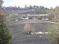
The fire threatened the Loy Yang Power Station
, particularly the station's open-cut
coal mine. On the night of 7 February, the fire approached the mine's overburden
dump, but did not damage any infrastructure, nor did it affect the station's operations. Several small fires broke out in the bunker storing raw coal from the mine, but were contained with no damage. The threat eased by the evening of 8 February as temperatures cooled and some light rain fell. One small spot fire broke out to the south of the power station, but it was contained by water bombing aircraft.
By 9 February, the Churchill fire complex was still burning out of control, with fronts through the Latrobe Valley
and the Strzelecki Ranges
. By late that afternoon, the complex had burnt out 32860 hectares (81,198.8 acre) and had killed eleven people. Wind changes that evening exacerbated parts of the Churchill complex, causing the CFA to issue further warnings to residents at Won Wron and surrounding areas.
Investigators revealed that they strongly believed arson was the most likely cause of the Churchill fire. A man from Churchill was arrested by police in relation to the Churchill fires at 4:00 pm on 12 February and was questioned at the Morwell police station; the following day he was charged with one count each of arson causing death, intentionally lighting a bushfire, and possession of child pornography
. On 16 February, a suppression order was lifted and the accused arsonist was named in the media as Churchill resident Brendan Sokaluk, 39.

 In Upper Ferntree Gully
a fire damaged the rail track and caused the closure of the Belgrave railway line, as well as all major roads. The fire, which was contained by CFA crews within three hours, burned at least 2 ha (4.9 acre) along the railway.
In the southern Dandenong Ranges, bushfires ignited around Narre Warren
, one of which was caused by sparks from a power tool. Six homes were destroyed in Narre Warren South
and three in Narre Warren North
.
In the weeks following Black Saturday, fires were started in bushland along Terrys Avenue in Belgrave
(which was quickly contained and extinguished by the CFA), and Lysterfield State Forest in Upwey
. Amongst the damage was the almost new Upper Ferntree Gully
CFA Tanker 1.
which burned more than 11000 ha (27,181.6 acre). This fire posed no immediate threat to campers, but due to excessive fuel and inaccessibility authorities chose to evacuate the park, with some campers being evacuated by boat.
At a community meeting on 11 February, DSE and Parks Victoria
authorities revealed a plan to back-burn across the entrance to the promontory, in order to prevent any possibility of the fire burning out of the park and into farmland and towards the towns of Yanakie
and Sandy Point
. Crikey
reported that locals were divided on the merits of the plan, some concerned as to why the back-burning had not been carried out earlier, and some worried at the large scale of the proposed burns, which were reported to be larger than both the existing fire as well as the April 2005 fires that affected the park Strong easterly winds on 12 February forced authorities to postpone the proposed burns lest they themselves pose a danger to surrounding communities, though they did proceed with preparatory work.
 The Maroondah/Yarra complex was a combination of several fires that had earlier been burning to the east of Healesville
and Toolangi on 10 February, as part of the greater Kilmore East – Murrindindi complex south. By late that morning, the complex had burned out 505 hectares (1,247.9 acre), with 184 personnel and 56 tankers responding to the fires. A CFA spokesperson said that while temperatures had cooled, strong winds were proving problematic, with towns in the area being threatened by ember
s blown from the fires. Around midday, the immediate threat to property in the areas around Healesville was downgraded, though a DSE spokesperson said that residents should be mindful of localised changes in the weather.
fire burnt 5700 ha (14,085 acre), including the golf club and eight homes. Two firefighters from the Dimboola
brigade narrowly escaped when their ute
was engulfed by fire.
The fire was ignited at 12:30 pm on 7 February when strong winds initiated the failure of a 40-year-old tie wire, felling a power line at Remlaw, west of the city. The fire spread southwest and then southeast, across the Wimmera Highway
and Wimmera River
, to the Horsham Golf Course, and then to Haven
, south of the city. Firefighters managed to save the general store, town hall and school at Haven, though flames came within metres of those buildings. Winds of up to 90 km/h (55.9 mph) changed direction three times throughout the day, producing conditions described by the local CFA incident controller as the worst he had ever seen. To the southwest of Horsham an 82-year-old woman in a wheelchair and her daughter were collected from her house by a taxi when the fire was no more than 100 m (109.4 yd) away; the house was alight as the taxi drove off, and burned down within minutes.
At 3:00 pm more than 400 personnel were engaged in fighting the fire, as well as two water-bombing aircraft, 54 CFA tankers, and 35 DSE units. By 6:00 pm the front had moved east, and a wind change then pushed it northeast across the Western Highway to Drung, east of Horsham.
in western Victoria. In gusting winds, a corroded tie wire holding a 48 year old Single wire earth return (SWER)
conductor to an insulator failed due to metal fatigue. The insulator was atop Pole 3 37°34′51.7"S 141°38′28.8"E on the 12,700-volt Colfitz North spur line. The galvanised steel conductor swung free in the wind, suspended by poles 2 and 4, a span of 540 m (1,771.7 ft). It is not believed to have touched the ground, but was pushed into a nearby eucalyptus tree by the strong prevailing wind.
Burning gumleaves fell to the ground and ignited grass, from which the fire grew extremely rapidly in the hot, dry and windy conditions. Over 230 firefighters, with 43 appliances and two water bombing aircraft, worked to contain the fire which burnt 770 ha (1,902.7 acre). The fire destroyed one house, two haysheds, three tractors, the Coleraine Avenue of Honour, and 200 km (124.3 mi) of fences, as well as injuring livestock, but firefighters were able to save six other homes, including that of the parents of Victorian Premier John Brumby
.
The fire threatened to burn through the township, but a wind change around 2:00 pm pushed the fire to the northeast instead. The regional CFA operations officer said of the wind change that "[a]ll that happened within about an hour and we were lucky; we thought it would go through Coleraine, but it headed off at the last minute." At about 6:00 pm the fire was controlled.
A local man was badly burned while helping a farmer move livestock out of harms way; the man was caught when the same wind change that saved the town pushed the fire in his direction, and he suffered burns to 50% of his body. Within a month the man was making a good recovery after extensive skin grafting by burns specialists.
, a fire burnt 1300 ha (3,212.4 acre), and damaged the rail line between Geelong
and Warrnambool
. Approximately 3,000 sleepers were burnt across a 4 km (2.5 mi) section of track. The rail line was re-opened by 16 February.
The fire caused unquantified losses of stock, and destroyed several outbuildings, but all houses under threat were saved by CFA firefighters. The fire is thought to have been started by sparking from felled power lines along the Princes Highway
, which carried restricted speeds for a short time due to the heavy smoke in the area.
into the Black Saturday bushfires was conducted, a process that was intended to determine the true nature of the background causes, preparation of responsible agencies, circumstances on the day, chronology, and impacts of the events in question.
, formed a taskforce to assist in identifying victims, coordinated by Inspector Greg Hough. Around forty police from interstate and overseas assisted with Disaster Victim Identification (DVI). The police were sourced from the Australian Federal Police, Tasmania, New South Wales, Queensland, Northern Territory, Western Australia, New Zealand, and Indonesia. New Zealand police also provided four victim identification dogs and handlers.
. Chief Commissioner Nixon stated on 9 February 2009 that all fire sites would be treated as crime scene
s.
On 9 February a man was arrested in connection with the fires at Narre Warren; it was alleged by police that he had been operating a power tool, sparks from which ignited a grass fire, destroying two houses. On 12 February, two people were arrested in connection with the fires, having been observed by members of the public acting suspiciously in areas between Yea
and Seymour
, however they were subsequently released without charges being laid.
A man from Churchill was arrested by police on 12 February, in relation to the Churchill fires, and was questioned at the Morwell police station, before being charged on 13 February with one count each of arson causing death, intentionally lighting a bushfire, and possession of child pornography
. At a file hearing in the Magistrates' Court
in Melbourne on 16 February the man was remanded in custody
ahead of a committal hearing
scheduled for 26 May. Following the hearing, a suppression order on the 39-year-old man's identity was lifted, though the order remained in force with respect to publishing his address or any images of him. Despite the order, several members of the public obtained his photograph from his MySpace
profile and published it on the social networking website Facebook
along with his home address, and others made threats of violence against him. The man's lawyer said that, as a consequence of that information being published, threats were made against the man's family. The man's ex-girlfriend and her family were also harassed after the Herald Sun
newspaper published a photograph and a story about her. On 17 February, after requests from Victoria Police, the man's MySpace profile was removed; Facebook commenced deleting postings containing threats, and deleted a photo from one group.
had been posted. Witnesses reported seeing acts of looting occurring at a property at Heathcote Junction
, shortly after the removal of the body of a victim from the property. That evening, via a report on ABC Local Radio
, a number of residents of Kinglake
who had been allowed back into the area to inspect the damage, revealed that a "Looters Will Be Shot" sign had been posted in the town, after a number of suspicious people and vehicles were seen moving through the town. On 12 February, a small number of arrests were made, and charges laid against people in relation to "looting offences", as announced by Police Chief Commissioner Christine Nixon
.
 A total of 173 people were confirmed to have died as a result of the fires. The figure was originally estimated at 14 on the night of 7 February, and steadily increased over the following two weeks to 210. It was feared that it could rise as high as 240–280, but these figures were later revised down to 173 after further forensic examinations of remains, and after several people previously believed to be missing were located.
A temporary morgue was established at the Coronial Services Centre at Southbank
, capable of holding up to three hundred bodies. The Victorian Coroner compared this to a similar facility established after the July 2005 London bombings
. By the morning of 10 February, 101 bodies had been transported to the temporary morgue. The Victorian Institute of Forensic Medicine stated that it could be impossible to positively identify many of the remains.
On 11 February, fire authorities estimated that as many as 100 of Marysville
's 519 residents could have perished. By 16 February, over 150 forensic investigators were engaged in searching the ruins of Marysville. A senior lecturer in fire ecology from the University of Melbourne
estimated that the fires may have been burning at temperatures of 1200 °C (2,192 °F), and concluded that, as a result, the remains of some people caught in the fires may have been obliterated. The final death toll for Marysville was later downgraded to 34 after a large group of residents who remained unaccounted for were officially located.
Among the dead in the Kinglake
West area were former Seven Network
and Nine Network
television personality Brian Naylor
, and his wife Moiree. Actor Reg Evans
and his partner, artist Angela Brunton, residing on a small farm in the St Andrews area, also died in the Kinglake area fire. Ornithologist Richard Zann perished in the Kinglake fire, together with his wife Eileen and daughter Eva.
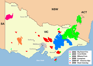
 General statistics
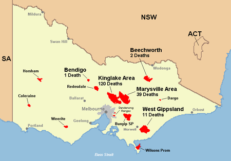
Location of deaths:
Locality of deaths:
Kinglake/Whittlesea Area (120)
Marysville Area (39)
Central Gippsland (11)
Beechworth (2)
Bendigo (1)
Total: 173
 A total of 414 people were injured during the Black Saturday bushfires. Due to the intensity and speed of the fires, most casualties of the bushfires either died, or survived with minor injuries. There were significantly fewer major burns than in previous bushfires, such as Ash Wednesday
. Of the people who presented to medical treatment centres and hospitals, there were 22 with serious burns and 390 with minor burns and other bushfire-related injuries.
National and statewide burns disaster plans were activated. Twenty-two patients with major burns presented to the state’s burns referral centres, of which eighteen were adults. One patient admitted to the Royal Children's Hospital
and two at The Alfred Hospital
died from their injuries. Adult burns patients at The Alfred spent 48.7 hours in theatre in the first 72 hours. There were a further 390 bushfire-related presentations across the state in the first 72 hours. Most patients with serious burns were triage
d to, and managed at, burns referral centres. Throughout the disaster, burns referral centres continued to have substantial surge capacity.
 It was estimated that the amount of energy released during the firestorm in the Kinglake-Marysville area was equivalent to the amount of energy that would be released by 1,500 Hiroshima-sized atomic bombs
.
Beyond the casualty list detailed above, physical damage caused by the bushfires included: burnt
In September 2009 it was announced that Australia's most prominent fire ecologist
, Kevin Tolhurst, was developing a new course for the University of Melbourne
on fire behaviour. Later that month the City of Manningham
announced it was developing the state's first integrated fire management plan in conjunction with the interim findings of the Royal Commission. It is expected that eventually all Victorian councils responsible for both urban and rural land will need to develop such plans, which define fire risks in open space
areas, along major roads, and in parkland.
In September/October 2009, it was announced that a new fire hazard system would replace the previous one. The new system involves a six-tier scale to indicating such things as the level of risk and activity of the fire. This standardised Fire Danger Rating (FDR) was subsequently adopted by all Australian states in late 2009. Every day during the fire season the Bureau of Meteorology (BOM) forecasts an outlook of the Fire Danger Index (FDI) by considering the predicted weather including temperature, relative humidity, wind speed, and dryness of vegetation. On the highest risk days, residents are advised to leave the potentially affected areas.
 The RSPCA
estimated that over a million animals perished in the bushfires. Additionally, many of the surviving wildlife
suffered from severe burns. For example, large numbers of kangaroo
s were afflicted with burned feet due to territorial instincts that drew them back to their recently burned and smouldering home ranges. The affected area, particularly around Marysville, contains the only known habitat of Leadbeater's Possum
, Victoria's faunal emblem, putting this species under further threat.
Forested catchment areas
supplying five of Melbourne's nine major dams were affected by the fires, with the worst affected being the Maroondah Reservoir
and O'Shannassy Reservoir
. As of 17 February 2009, over ten billion litres of water had been shifted out of affected dams into others. A Melbourne Water
spokesperson said that affected dams may need to be decommissioned if the contamination from ash and other material were serious enough, and also said that forest regrowth in the burnt-out catchment areas could reduce runoff yields by up to 30% over the next three decades.
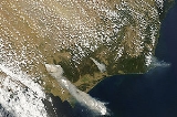
In early March 2009, smoke from the fires was discovered in the atmosphere over Antarctica at record altitudes.
 While it is difficult to attribute an individual weather event, such as the current extended drought in southeastern Australia, to an overall climatic pattern such as global warming, it is possible to correlate patterns with other patterns. Although the current drought could be the result of natural weather pattern variability, it is embedded in a 50-year warming trend that can be attributed with confidence to human-induced increases in greenhouse gas emissions.
This warming trend is, in turn, expected to continue in proportion to an increase in the intensity and frequency of Australian fires. Following the fires, commentators such as noted scientist Tim Flannery
, Australian Greens
leader Bob Brown
, and leading and volunteer firefighters argued that the number of extreme fire days in Australia is likely to increase substantially due to climate change
, and that governments should therefore invest more in reducing emissions. A study by the Australian Bureau of Meteorology and the CSIRO which forecast that the risk of extreme fire-weather is likely to increase substantially throughout southeast Australia by 2050 was cited in support.
A more recent report by Greenpeace
and a state firefighters union predicted that "mega-fires" could occur once every three years in the bush around Melbourne. A month after its release the United Firefighters Union of Australia
issued an open letter
to the Prime Minister and Premier Brumby which stated that "we are well on the way to guaranteeing that somewhere in the country there will be an almost annual repeat of the recent disaster", and pleaded for emissions to be halved by 2020.
A study completed after the bushfires by the CSIRO found that the Indian Ocean Dipole
was at least partially to blame. It was determined that the phenomenon was also a factor in the extended drought that Australia suffered for many years, and as this was a contributing factor in establishing the favourable fire conditions, it added further support to the contention that the dipole was an important factor in the fires.
The largest contributor to the total cost was insurance claims, which the Insurance Council of Australia reported as $1.2 billion as of August 2010. This figure was composed of 84 per cent for property or contents, and 16 per cent for vehicles. However the report also estimated that up to 13 per cent of residential properties destroyed may have had no insurance, with many more under-insured, thus suggesting that the actual cost of asset damage in the bushfires was considerably higher than that recorded. The report from the commission said that: "... the level of insurance claims is likely to underestimate the true extent of property losses, but it is unable to calculate the extent of this underestimation".
Also omitted from the $4.4 billion figure were the agricultural losses sustained in the fires, and the ongoing impacts on agriculture in following seasons. The Victorian Department of Primary Industries estimated losses shortly after the fires as 11,800 head of livestock, 62000 hectares (153,205.2 acre) of grazing pasture
, and 32000 tonne of hay
and silage
.
As of February 2011, two years after the fires, the Victorian Bushfire Reconstruction and Recovery Authority stated that based on figures from the end of 2010, permits had been issued for the rebuilding of only 731 of the 1,795, or 41 per cent of the principal places of residence destroyed in the fires.
lawsuit was initiated in the Supreme Court of Victoria
on 13 February by Slidders Lawyers against electricity distribution company SP AusNet, in relation to the Kilmore East
fire that became part of the Kinglake complex, and the Beechworth
fires. A partner at the firm indicated that the claim would centre on alleged negligence
by SP AusNet in its management of electricity infrastructure. On 12 February police had taken away a section of power line as well as a power pole from near Kilmore East
, part of a two-kilometre section of line that fell on the morning of 7 February and was believed to have started the fire there.
A separate class action claim was expected to be commenced by Gadens Lawyers some time after 16 February, and Slater & Gordon
indicated that they were awaiting the report of the to-be-established Royal Commission
, expected in late 2010, before initiating any claims.
Also on 13 February, five law firms from Victoria's Western Districts held a meeting to discuss a potential class action in relation to the Horsham
fire, which was also thought to have been started by fallen power lines.
Over 600 bushfire victims signed up for a class action lawsuit against Singapore Power
, majority shareholder of SP Ausnet. The action alleges the power company failed to fit a $10 protective device on the power line, which contributed to it breaking and starting the devastating Kilmore East/Kinglake fire.
 In the wake of the fires, and the mounting casualty toll, there was debate about policies for dealing with bushfires and the management practices that may have contributed to them. Naomi Brown, chief executive of the Australasian Fire and Emergency Services Authorities Council, argued that the high number of fatalities in these fires, as opposed to earlier fires such as the Ash Wednesday fires
, was partly attributable to increased population densities on Melbourne's fringes. David Packham, bushfire expert and research fellow at Monash University
, argued that high fuel loads in bushland led to the destructive intensity of the fires, saying that "There has been total mismanagement of the Australian forest environment".
In announcing that the fires would be investigated by a Royal Commission
, Victorian Premier John Brumby
suggested that the long-standing 'stay-and-defend-or-leave-early' policy would be reviewed, saying that while it had proven reliable during normal conditions, the conditions on 7 February had been exceptional. Brumby said that "There were many people who had done all of the preparations, had the best fire plans in the world and tragically it didn't save them."
Commissioner Nixon, however, defended the policy, saying that it was "well thought of and well based and has stood the test of time and we support it". Similarly, Commissioner of the New South Wales Rural Fire Service
, Shane Fitzsimmons, said that "Decades of science, practice and history show that a well-prepared home provides the best refuge in the event of fire". Nixon also dismissed potential policies involving forced evacuations, saying "There used to be policies where you could make people leave but we're talking about adults". Former Victorian police minister Pat McNamara argued that forced evacuations could have worsened the death toll, as many of the dead appeared to have been killed while attempting to evacuate the fire areas by car.
Based on this information, the Building Commission Victoria has released a range of publications to assist with people returning to properties, moving into temporary dwellings, retrofitting existing dwellings, and building new dwellings in bushfire areas. The new standard states that all properties (not just those in bushfire areas) will now require a "bushfire attack assessment", and will be given a Bushfire Attack Level (BAL) rating that outlines the type of construction required. The BAL takes into consideration such factors as the Fire Danger Index
, the slope, and surrounding vegetation. BALs range from "BAL-LOW", for properties with no specific construction requirements such as suburban buildings, to "BAL-FZ" for properties in the fire zone likely to experience direct exposure to the fire front, as well as high heat flux and ember attacks.
While a draft national building code for bushfire-prone areas proposed using 1000 K (726.9 °C; 1,340.3 °F) as the standard for the assumed temperature to which houses are subject when hit by bushfire, fire engineers argued that standards should be based on a 1090 K (816.9 °C; 1,502.3 °F) temperature. This was in line with existing New South Wales building laws for bushfire-prone areas, although the temperature of fires can actually peak at approximately 1600 K (1,326.9 °C; 2,420.3 °F). The Australian Building Codes Board incorporated the 1090 K (816.9 °C; 1,502.3 °F) temperature in the standard, with the support of the CFA and Australasian Fire Authorities Council
.
said that after the 1983 Ash Wednesday fires the government bought back tens of thousands of lots across the Dandenong Ranges
because they were in extremely high fire risk areas; he backed another similar large-scale buyback scheme to move people away from unacceptably high risk areas.
Another member of the panel, International Planning expert Professor Roz Hansen, said she was "disappointed and alarmed" about the decision to rebuild Marysville, stating that it was unlikely that a new development would have been permitted in the area. She further went on to say that in other parts of Asia people had been forcibly moved out of unacceptably high risk cyclone and flooding areas in the public interest, despite the difficulties this involved.
Australia
Australia , officially the Commonwealth of Australia, is a country in the Southern Hemisphere comprising the mainland of the Australian continent, the island of Tasmania, and numerous smaller islands in the Indian and Pacific Oceans. It is the world's sixth-largest country by total area...
n state of Victoria
Victoria (Australia)
Victoria is the second most populous state in Australia. Geographically the smallest mainland state, Victoria is bordered by New South Wales, South Australia, and Tasmania on Boundary Islet to the north, west and south respectively....
on and around Saturday, 7 February 2009. The fires occurred during extreme bushfire-weather conditions, and resulted in Australia's highest ever loss of life from a bushfire; 173 people died and 414 were injured as a result of the fires.
As many as 400 individual fires were recorded on 7 February. Following the events of 7 February 2009 and its aftermath, that day has become widely referred to as Black Saturday.
Overview
Conditions
The majority of the fires ignited and spread on a day of some of the worst bushfire-weather conditions ever recorded. Temperatures in the mid- to high 40 degrees Celsius (approx. 110–120 °F), and wind speedWind speed
Wind speed, or wind velocity, is a fundamental atmospheric rate.Wind speed affects weather forecasting, aircraft and maritime operations, construction projects, growth and metabolism rate of many plant species, and countless other implications....
s in excess of 100 km/h (62.1 mph), precipitated by an intense heat wave, and almost two months of little or no rain, fanned the fires over large distances and areas. This created several large firestorms and pyrocumulus systems
Pyrocumulus cloud
A pyrocumulus, or literally fire cloud, is a dense cumuliform cloud associated with fire or volcanic activity.A pyrocumulus is similar dynamically in some ways to a firestorm, and the two phenomena may occur in conjunction with each other...
, particularly northeast of Melbourne, where a single firestorm accounted for 120 of the 173 deaths. A cool change hit the state in the early evening, bringing with it gale-force southwesterly winds in excess of 120 km/h (74.6 mph). This change in wind direction caused the long eastern flanks of the fires to become massive fire fronts that burned with incredible speed and ferocity towards towns that had earlier escaped the fires.
The fires destroyed over 2,030 houses and more than 3,500 structures in total, as well as damaging thousands more. Many towns northeast of the state capital Melbourne
Melbourne
Melbourne is the capital and most populous city in the state of Victoria, and the second most populous city in Australia. The Melbourne City Centre is the hub of the greater metropolitan area and the Census statistical division—of which "Melbourne" is the common name. As of June 2009, the greater...
were badly damaged or almost completely destroyed, including Kinglake
Kinglake, Victoria
Kinglake is a town in Victoria, Australia situated in the Shire of Murrindindi local government area. At the 2006 Census, Kinglake had a population of 1482...
, Marysville
Marysville, Victoria
Marysville is a small town, 34 kilometres north-east of Healesville, in the Shire of Murrindindi in Victoria, Australia. The town, which previously had a population of around 500 people, was devastated by the Murrindindi Mill bushfire on 7 February 2009. On 19 February 2009 the official death toll...
, Narbethong
Narbethong, Victoria
Narbethong is a town in central Victoria, Australia. The town is located on the Maroondah Highway, north east of the state capital, Melbourne. At the 2006 census, Narbethong and the surrounding area had a population of 280....
, Strathewen
Strathewen, Victoria
Strathewen is a locality situated near Kinglake National Park, from central Melbourne in Victoria, Australia, with a population of around 200. It is an apple and pear producing area and is home to small local vineyards and wineries.-History:...
, and Flowerdale
Flowerdale, Victoria
Flowerdale is a town in Victoria, Australia. The town is located in the Shire of Murrindindi Local Government Area, from the state capital, Melbourne...
. Many houses in the towns of Steels Creek
Steels Creek, Victoria
Steels Creek is a town in Victoria, Australia, 45 km north-east from Melbourne's central business district, 6km north of Yarra Glen. Its Local Government Area is the Shire of Yarra Ranges....
, Humevale
Humevale, Victoria
Humevale is a rural locality in Victoria, Australia located between Whittlesea and Kinglake West, about north-north-east of Melbourne, within the City of Whittlesea. It is also referred to as Scrubby Creek after a nearby watercourse....
, Clonbinane
Clonbinane, Victoria
During the development of the Australian colonies, the Clonbinane area was part of the Colony of New South Wales between 1788 and 1851 when, on 1 July 1851, Victoria was separated from New South Wales. An early mention of the name Clonbinane appeared in Melbourne's Argus Newspaper of 29 September...
, Wandong
Wandong, Victoria
Wandong is a town in Victoria, Australia. The town is about north of the state capital, Melbourne, on the Hume Highway. It is located right next to the town of Heathcote Junction, and at the 2006 census, the two towns had a population of 1,490.. The main centre nearest Wandong is Kilmore.Wandong...
, St Andrews, Callignee
Callignee, Victoria
Callignee is a locality in the Gippsland region of Victoria, Australia. The locality is east of the state capital, Melbourne. At the 2006 census, Callignee and the surrounding area had a population of 495....
, Taggerty
Taggerty, Victoria
Taggerty is a town in central Victoria, Australia. It is located at the intersection of Maroondah Highway and Thornton Road. The Acheron River also crosses the highway at Taggerty. It is thought to be named after the Aboriginal word for blue clay. At the 2006 Census, Taggerty and the surrounding...
, and Koornalla were also destroyed or severely damaged, with several fatalities recorded at each location.
The fires affected 78 individual townships in total, and displaced an estimated 7,562 people. Many of those displaced sought temporary accommodation, much of it donated in the form of spare rooms, caravans, tents, and beds in community relief centres.
Causes
The majority of the fires were ignited by fallen or clashingShort circuit
A short circuit in an electrical circuit that allows a current to travel along an unintended path, often where essentially no electrical impedance is encountered....
power lines, or were deliberately lit
Arson
Arson is the crime of intentionally or maliciously setting fire to structures or wildland areas. It may be distinguished from other causes such as spontaneous combustion and natural wildfires...
. Other suspected ignition sources included lightning
Lightning
Lightning is an atmospheric electrostatic discharge accompanied by thunder, which typically occurs during thunderstorms, and sometimes during volcanic eruptions or dust storms...
, cigarette butts, and sparks from a power tool. Also implicated in the underlying conditions was a major drought
Drought in Australia
Drought in Australia is defined as rainfall over a three month period being in the lowest decile of what has been recorded for that region in the past. This definition takes into account that drought is a relative term and rainfall deficiencies need to be compared to typical rainfall patterns...
that had persisted for more than a decade, as well as a domestic warming trend that has been linked to human-induced climate change
Climate change
Climate change is a significant and lasting change in the statistical distribution of weather patterns over periods ranging from decades to millions of years. It may be a change in average weather conditions or the distribution of events around that average...
. By early to mid-March, favourable conditions aided containment efforts, and helped to extinguish the fires.
Background
Melbourne
Melbourne is the capital and most populous city in the state of Victoria, and the second most populous city in Australia. The Melbourne City Centre is the hub of the greater metropolitan area and the Census statistical division—of which "Melbourne" is the common name. As of June 2009, the greater...
broke records by sweltering through three consecutive days above 43 °C (109.4 °F), with the temperature peaking at 45.1 °C (113.2 °F) on 30 January, the third hottest day in the city's history.
The heatwave was caused by a slow moving high-pressure system
Atmospheric pressure
Atmospheric pressure is the force per unit area exerted into a surface by the weight of air above that surface in the atmosphere of Earth . In most circumstances atmospheric pressure is closely approximated by the hydrostatic pressure caused by the weight of air above the measurement point...
that settled over the Tasman Sea
Tasman Sea
The Tasman Sea is the large body of water between Australia and New Zealand, approximately across. It extends 2,800 km from north to south. It is a south-western segment of the South Pacific Ocean. The sea was named after the Dutch explorer Abel Janszoon Tasman, the first recorded European...
, with a combination of an intense tropical low
Tropical cyclone
A tropical cyclone is a storm system characterized by a large low-pressure center and numerous thunderstorms that produce strong winds and heavy rain. Tropical cyclones strengthen when water evaporated from the ocean is released as the saturated air rises, resulting in condensation of water vapor...
located off the North West Australia
North West Australia
The terms North West Australia, The North West and North Western Australia have been used as a regular label for the region of the North of Western Australia and the West of the Northern Territory.- Early 20th century gold rush:...
n coast and a monsoon trough
Monsoon trough
The monsoon trough is that portion of the Intertropical Convergence Zone which extends into or through a monsoon circulation, as depicted by a line on a weather map showing the locations of minimum sea level pressure, and as such, is a convergence zone between the wind patterns of the southern and...
over northern Australia
Northern Australia
The term northern Australia is generally known to include two State and Territories, being Queensland and the Northern Territory . The part of Western Australia north of latitude 26° south—a definition widely used in law and State government policy—is also usually included...
, which produced ideal conditions for hot tropical air to be directed down over southeastern Australia.
The February fires commenced on a day when several localities across the state, including Melbourne
Melbourne
Melbourne is the capital and most populous city in the state of Victoria, and the second most populous city in Australia. The Melbourne City Centre is the hub of the greater metropolitan area and the Census statistical division—of which "Melbourne" is the common name. As of June 2009, the greater...
, recorded their highest temperatures since records began in 1859. On 6 February 2009—the day before the fires started—the Premier of Victoria John Brumby
John Brumby
John Mansfield Brumby , is an Australian Labor Party politician who was Premier of Victoria from 2007 to 2010. He became Premier after the resignation of Steve Bracks. He also served as the Minister for Veterans' Affairs and the Minister for Multicultural Affairs. He contested his first election...
issued a warning about the extreme weather conditions expected on 7 February: "It's just as bad a day as you can imagine and on top of that the state is just tinder-dry. People need to exercise real common sense tomorrow". The Premier went on to state that it was expected to be the "worst day [of fire conditions] in the history of the state".
Events of Saturday 7 February
Country Fire Authority
Country Fire Authority, or CFA, is the name of the fire service that provides firefighting and other emergency services to all of the country areas and regional townships within the state of Victoria, Australia, as well as large portions of the outer suburban areas and growth corridors of Melbourne...
and Department of Sustainability and Environment (DSE), were deployed across the state on the morning of 7 February in anticipation of the extreme conditions. By mid-morning, hot northwesterly winds in excess of 100 kilometres per hour (62.1 mph) hit the state, accompanied by extremely high temperatures and extremely low humidity. Also a total fire ban for the entire state was declared.
As the day progressed, all-time record temperatures were being reached. Melbourne hit 46.4 °C (115.5 °F), the hottest temperature ever recorded in an Australian capital city, and humidity levels dropped to as low as six percent. The McArthur Forest Fire Danger Index
McArthur Forest Fire Danger Index
The McArthur Forest Fire Danger Index was developed in the 1960s by CSIRO scientist A.G. McArthur to measure the degree of danger of fire in Australian forests. The index combines a record of dryness, based on rainfall and evaporation, with meteorological variables for windspeed, temperature and...
reached unprecedented levels, ranging from 120 to over 200. This was higher than the fire weather conditions experienced on Black Friday
Black Friday (1939)
The Black Friday fires of 13 January 1939, in Victoria, Australia, were considered one of the worst natural bushfires in the world, and certainly the single worst in Australian history as a measure of land affected...
in 1939 and Ash Wednesday
Ash Wednesday fires
The Ash Wednesday bushfires, known in South Australia as Ash Wednesday II, were a series of bushfires that occurred in south-eastern Australia on 16 February 1983. Within twelve hours, more than 180 fires fanned by winds of up to 110 km per hour caused widespread destruction across the states...
in 1983.
By midday wind speeds were reaching their peak, and by 12:30 pm powerlines were felled in Kilmore East by the high winds. These sparked a bushfire that would later generate extensive pyrocumulus clouds, and become the largest, deadliest, and most intense firestorm ever experienced in Australia's post-European history. The overwhelming majority of fire activity occurred between midday and 7:00 pm, when wind speed and temperature were at their highest, and humidity at its lowest.
Chronology
- Delburn fire commenced in Central Gippsland; arson suspected.
Wednesday, 4 February
- Bunyip State Park fire commenced.
Saturday, 7 February (Black Saturday)
- Mid-morning – Bunyip State Park fire jumped containment lines; no other major fire activity.
- Late morning – many fires sprang up as temperatures rose and wind speeds increased.
- 11:20 am – power lines were felled in high winds igniting the Kilmore East fire (Kinglake/Whittlesea area). The fire was fanned by 125 km/h (77.7 mph) winds, entered a pine plantation, grew in intensity, and rapidly headed southeast through the Wandong area.
- 12:30 pm – Horsham fire commenced.
- Early afternoon – ABC Radio received calls from residents of affected areas supplying immediate up-to-date information on fire activity.
- 2:55 pm – Murrindindi Mill fire (Marysville area) first spotted from Mt Despair fire tower.
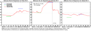
- 3:04 pm – temperature in Melbourne peaked at 46.4 °C (115.5 °F).
- 4:20 pm – Kilmore East fire front arrived at Strathewen.
- 4:20 pm – fire impacted Narbethong.
- Mid-afternoon – smoke from Kilmore East firestorm prevented planes from mapping the fire edge.
- 4:30 pm – number of individual fires across the state increased into the hundreds.
- 4:30 pm – fire commenced at Eaglehawk, near Bendigo.
- 4:45 pm – Kilmore East fire front arrived at Kinglake.
- 5:00 pm – wind direction changed from northwesterly to southwesterly in Melbourne (see Fawkner Beacon Wind chart for 7 February 2009).
- 5:10 pm – air temperature in Melbourne dropped from over 45 °C (113 °F) to around 30 °C (86 °F) in fifteen minutes.
- 5:30 pm – wind change arrived at Kilmore East and Murrindindi Mill (Kinglake/Marysville) fire fronts.
- 5:45 pm – Kilmore East fire front arrived in Flowerdale.
- 6:00 pm – Beechworth fire commenced.
- 6:00 pm – Kilmore East fire smoke plume and pyrocumulus cloud reached 15 km (9.3 mi) high.
- 6:45 pm – Murrindindi Mill fire front arrived at Marysville.
- 8:30 pm – Victorian Health Emergency Co-ordination Centre notified Melbourne hospitals to prepare for burn victims.
- 8:57 pm – CFA chief officer first notified that casualties had been confirmed.
- 10:00 pm – Victoria Police announced an initial estimate of 14 fatalities.
Sunday, 8 February
- Kilmore East and Murrindindi Mill fires merged to form the Kinglake fire complex.
- Wilsons Promontory fire ignited by lightning.
- Victoria Police increased estimate to 25 fatalities.
- Spot fires from Kinglake complex fires merged to form the Maroondah/Yarra complex.
Tuesday, 17 February
- Six fires still burnt out of control, with another nineteen contained.
- Containment lines surrounded 85 per cent of the Kinglake–Murrindindi complex.
- The Kilmore East – Murrindindi complex south fire burned in Melbourne's O'Shannassy and Armstrong Creek water catchments.
- The Bunyip and Beechworth fires almost contained.
Thursday, 19 February
- Victoria Police increased estimate to 208 fatalities.
Monday, 23 February
- Temperatures in the mid-30 degrees Celsius (mid-90 degrees Fahrenheit), northerly winds, and a cool change precipitated a flare up of many of the fires, and ignited several new fires. The most significant new fires were in the southern Dandenong RangesDandenong RangesThe Dandenong Ranges are a set of low mountain ranges, rising to 633 metres at Mount Dandenong, approximately 35 km east of Melbourne, Victoria, Australia...
near UpweyUpwey, VictoriaUpwey is a suburb in Melbourne, Victoria, Australia, east from Melbourne's central business district. Its Local Government Area is the Shire of Yarra Ranges and City of Knox. At the 2006 Census, Upwey had a population of 6,760.-History:...
, south of DaylesfordDaylesford, VictoriaDaylesford is a town located in the Shire of Hepburn, Victoria, Australia. It is a former goldmining town about 115 kilometres north-west of Melbourne, in the foothills of the Great Dividing Range. At the 2006 census, Daylesford had a population of 3,073...
, and in the Otway Ranges. Weather conditions directed previously burning fires in the Yarra Ranges towards settlements in the upper Yarra Valley, but the fires were of a low intensity and were quickly contained.
Friday, 27 February
- The Bunyip fire still burnt within control lines in the Bunyip State Park and State Forest areas.
- The Kilmore East – Murrindindi complex north fire burnt within containment lines on the southeastern flank.
- The Kilmore East – Murrindindi complex south fire activity continued in areas close to several towns in the Yarra Valley near both Yarra Glen and Warburton.
- The Wilsons Promontory Cathedral fire had burnt 24150 ha (59,675.9 acre) and was still burning.
- The French Island fire slowly burnt in uninhabited grass and scrub bushland on the northeast end of the island.
Tuesday, 3 March 2009:
- Extreme bushfire conditions predicted for Monday night and early Tuesday morning, involving very strong northerlies, with a change forecast to arrive by Tuesday morning. Three million SMSShort message serviceShort Message Service is a text messaging service component of phone, web, or mobile communication systems, using standardized communications protocols that allow the exchange of short text messages between fixed line or mobile phone devices...
messages warning of extreme fire danger conditions were sent by the mobile phone companies, on behalf of Victoria PoliceVictoria PoliceVictoria Police is the primary law enforcement agency of Victoria, Australia. , the Victoria Police has over 12,190 sworn members, along with over 400 recruits, reservists and Protective Service Officers, and over 2,900 civilian staff across 393 police stations.-Early history:The Victoria Police...
, to Victorians and Tasmanians with mobile phones as a technology trial.
Wednesday, 4 March
- Cooler conditions and rain from 4–6 March enabled firefighters to control and contain several fires, with the Kilmore East – Murrindindi complex south fire being completely contained. Predictions for favourable weather signalled the easing of the threat to settlements from the major fires that had been burning since 7 February.
Mid-March
- Favourable conditions aided containment efforts and extinguished many of the fires.
Kinglake–Marysville fires
Kinglake, Victoria
Kinglake is a town in Victoria, Australia situated in the Shire of Murrindindi local government area. At the 2006 Census, Kinglake had a population of 1482...
fire complex was named after two earlier fires, the Kilmore East
Kilmore East, Victoria
Kilmore East is a locality in the Australian state of Victoria, 90 kilometres north of Melbourne.Kilmore East railway and telegraph station was established in 1872 to serve Kilmore....
fire and the Murrindindi
Murrindindi, Victoria
Murrindindi is a locality along the valley of the Murrundindi River in Victoria, Australia in the Shire of Murrindindi local government area. The nearest town is Yea, Victoria....
Mill fire, merged following the wind change on the evening of 7 February. The complex was the largest of the many fires burning on Black Saturday, ultimately destroying over 330000 ha (815,447 acre). It was also the most destructive, with over 1,800 houses destroyed and 159 lives lost in the region.
Kinglake area (Kilmore East fire)
Just before midday on 7 February, high winds felled a 2 km (1.2 mi) section of power lines owned by SP AusNetSingapore Power
Singapore Power is a company which provides electricity and gas transmission, distribution services, and market support services to more than a million customers in Singapore. It is the only electricity company in Singapore, and is also one of the largest corporations in Singapore...
in Kilmore East, sparking a fire in open grasslands that adjoined pine plantations. The fire was fanned by extreme northwesterly winds, and travelled 50 km (31.1 mi) southeast in a narrow fire front through Wandong
Wandong, Victoria
Wandong is a town in Victoria, Australia. The town is about north of the state capital, Melbourne, on the Hume Highway. It is located right next to the town of Heathcote Junction, and at the 2006 census, the two towns had a population of 1,490.. The main centre nearest Wandong is Kilmore.Wandong...
and Clonbinane
Clonbinane, Victoria
During the development of the Australian colonies, the Clonbinane area was part of the Colony of New South Wales between 1788 and 1851 when, on 1 July 1851, Victoria was separated from New South Wales. An early mention of the name Clonbinane appeared in Melbourne's Argus Newspaper of 29 September...
, into Kinglake National Park
Kinglake National Park
Kinglake is a national park in Victoria, Australia, 50 kilometres northeast of Melbourne. The park includes tracks , and camping facilities....
, and then onto the towns of Humevale
Humevale, Victoria
Humevale is a rural locality in Victoria, Australia located between Whittlesea and Kinglake West, about north-north-east of Melbourne, within the City of Whittlesea. It is also referred to as Scrubby Creek after a nearby watercourse....
, Kinglake West
Kinglake West, Victoria
Kinglake West is a town in central Victoria, Australia. The town is located north east of the state capital, Melbourne. At the 2006 census, Kinglake West and the surrounding area had a population of 1,525....
, Strathewen
Strathewen, Victoria
Strathewen is a locality situated near Kinglake National Park, from central Melbourne in Victoria, Australia, with a population of around 200. It is an apple and pear producing area and is home to small local vineyards and wineries.-History:...
and St Andrews.
The cool change passed through the area around 5:30 pm, bringing strong southwesterly winds. The wind change turned the initial long and narrow fire band into a wide firefront that moved in a northeast direction through Kinglake
Kinglake, Victoria
Kinglake is a town in Victoria, Australia situated in the Shire of Murrindindi local government area. At the 2006 Census, Kinglake had a population of 1482...
, Steels Creek
Steels Creek, Victoria
Steels Creek is a town in Victoria, Australia, 45 km north-east from Melbourne's central business district, 6km north of Yarra Glen. Its Local Government Area is the Shire of Yarra Ranges....
, Chum Creek
Chum Creek, Victoria
Chum Creek is a town in Victoria, Australia, 50 km north-east from Melbourne's central business district. Its Local Government Area is the Shire of Yarra Ranges. At the 2006 Census, Chum Creek had a population of 848....
, Toolangi, Hazeldene
Hazeldene, Victoria
Hazeldene is a town in central Victoria, Australia. The town is located north of the state capital, Melbourne. At the 2006 census, Hazeldene had a population of 535....
, and Flowerdale
Flowerdale, Victoria
Flowerdale is a town in Victoria, Australia. The town is located in the Shire of Murrindindi Local Government Area, from the state capital, Melbourne...
.
The area become the worst impacted in the state, with a total of 120 deaths and more than 1,200 homes destroyed.
Marysville area (Murrindindi Mill fire)
Narbethong, Victoria
Narbethong is a town in central Victoria, Australia. The town is located on the Maroondah Highway, north east of the state capital, Melbourne. At the 2006 census, Narbethong and the surrounding area had a population of 280....
. Experienced Air Attack Coordinator Shaun Lawlor reported flame heights of "at least 100 metres" as the fire traversed the Black Range. At Narbethong, it destroyed 95 per cent of the town's houses. When the southerly change struck, it swept towards the town of Marysville
Marysville, Victoria
Marysville is a small town, 34 kilometres north-east of Healesville, in the Shire of Murrindindi in Victoria, Australia. The town, which previously had a population of around 500 people, was devastated by the Murrindindi Mill bushfire on 7 February 2009. On 19 February 2009 the official death toll...
.
Late in the afternoon of 7 February, residents had anticipated that the fire front would bypass Marysville. At about 5:00 pm, power was lost to the town. Around 5:30 pm, the wind died away, however, minutes later it returned from a different direction, bringing the fire up the valley with it.
Afterwards, a police sergeant said that the main street in Marysville had been destroyed: "The motel at one end of it partially exists. The bakery has survived. Don't ask me how. Everything else is just nuked." Reports on 11 February estimated that around 100 of the town's population of approximately 500 had believed to have perished, and that only "a dozen" buildings were left. Premier Brumby described the situation: "There's no activity, there's no people, there's no buildings, there's no birds, there's no animals, everything's just gone. So the fatality rate will be very high."
Eventually 34 fatalities were confirmed in the Marysville area, with all but 14 of over 400 buildings destroyed. Other localities severely affected included Buxton
Buxton, Victoria
Buxton is a small town north-east of Melbourne in the Australian state of Victoria. At the 2006 Census, Buxton had a population of 396.The district around Buxton was significantly impacted by the Black Saturday Bushfires...
and Taggerty
Taggerty, Victoria
Taggerty is a town in central Victoria, Australia. It is located at the intersection of Maroondah Highway and Thornton Road. The Acheron River also crosses the highway at Taggerty. It is thought to be named after the Aboriginal word for blue clay. At the 2006 Census, Taggerty and the surrounding...
.
To the south of the fire complex, visitors and residents were stranded at Yarra Glen
Yarra Glen, Victoria
Yarra Glen is a town in Victoria, Australia, 40 km north-east from Melbourne's central business district. Its Local Government Area is the Shire of Yarra Ranges...
when fire surrounded the town on three sides. Houses just to the north of Yarra Glen were destroyed and large areas of grassy paddocks burnt.
Investigators initially strongly believed that the cause of the fire that originated near the Murrundindi Mill and swept through Narbethong and Marysville was arson, with several suspects investigated. On 1 April 2009, Victoria Police reaffirmed their view that the cause was arson. However, in June 2011, Vicoria Police announced that they now believed the cause of the fire was not arson.
Beechworth fire
In BeechworthBeechworth, Victoria
Beechworth is a well-preserved historical town located in the north-east of Victoria, Australia, famous for its major growth during the gold rush days of the mid-1850s...
, a fire burnt over 30000 hectares (74,131.5 acre) and threatened the towns of Yackadandah
Yackandandah, Victoria
Yackandandah is a small tourist town in northeast Victoria, Australia. It is near the regional cities of Wodonga and Albury, and is close to the tourist town of Beechworth. At the 2006 census, Yackandandah had a population of 663.- History :...
, Stanley
Stanley, Victoria
Stanley is a small town approximately from Beechworth in Victoria noted for its apple & nut farms. At the 2006 census, Stanley had a population of 690.The town was formerly known as Snake Gully...
, Bruarong, Dederang
Dederang, Victoria
Dederang is a town in north east Victoria. The town is located on the Kiewa Valley Highway, in the Alpine Shire Local Government Areas of Australia, 329 kilometres from the state capital, Melbourne. Dederang is located in the Kiewa River valley...
, Kancoona
Kancoona, Victoria
Kancoona is a locality in north east Victoria, Australia. The locality is in the Kiewa Valley, north east of the state capital, Melbourne. At the 2006 census, Kancoona had a population of 210....
, Kancoona South, Coralbank, Glen Creek, and Running Creek. The fire ignited from a felled power line at around 6:00 pm on 7 February, 3 km (1.9 mi) south of Beechworth, before being driven south through pine plantations by hot northerly winds.
The fire destroyed an unknown number of buildings at Mudgegonga
Mudgegonga, Victoria
Mudgegonga is a locality in north east Victoria, Australia. The locality is north east of the state capital, Melbourne. At the 2006 census, Mudgegonga had a population of 384....
, southeast of Beechworth, with two residents confirmed dead. Dense smoke and cloud cover had hindered assessment of the Beechworth fire, but as conditions cleared late on 8 February, aerial crews were able to commence surveys of the situation.
Strong winds fuelled the fire on the night of 8 February, and lightning ignited a new fire near Kergunyah
Kergunyah, Victoria
Kergunyah is a locality in north eastern Victoria. The locality is on the Kiewa Valley Highway, north east of the state capital, Melbourne. At the 2006 census, Kergunyah had a population of 188.-References:...
around midday on 9 February. More than 440 personnel worked to contain a separate front that threatened Gundowring and Eskdale
Eskdale, Victoria
Eskdale is a small town near the major regional centre of Albury-Wodonga, in Victoria's north. It is situated in the Mitta Valley, near the river's confluence with the Little Snowy Creek, amongst the foothills of Mount Bogong...
, having jumped the Kiewa River
Kiewa River
The Kiewa River is a major tributary of the Murray River in Australia.The river's headwaters include Victoria's highest mountain, Mount Bogong, and wind their way north-west about 100 kilometres, gradually slowing before joining the Murray east of Albury....
. Late on the night of 9 February the greatest threat was to Eskdale, and fires also burnt in pine plantations 8 kilometres (5 mi) from the large town of Myrtleford
Myrtleford, Victoria
Myrtleford is a town in north-east Victoria, Australia, 45 km south-east of Wangaratta and 275 km north-east of Melbourne. Myrtleford is part of the Alpine Shire local government area and at the 2006 census the town had a population of 3,187....
, at the western end of the fire area. While smaller towns to the east, including Gundowring and Kergunyah, remained under threat, the CFA said that there was no immediate danger to the larger towns of Beechworth and Yackandandah on the northern fringe of the fire area.
By 10 February, firefighters had completed a 115 km (71.5 mi) containment line around the Beechworth fire, and sought to construct 15 km (9.3 mi) more, though the fire continued to burn out of control. By that afternoon, threat messages for the area had been downgraded, though firefighters were tackling a separate fire near Koetong, to the east of the main Beechworth fire, of between 50 to 80 ha (123.6 to 197.7 acre). Residents of Beechworth and surrounding towns were advised on the evening of 10 February to expect increased smoke cover as 250 firefighters would be undertaking backburning to eliminate fuel within the control lines.
The Beechworth Correctional Centre
Beechworth Correctional Centre
The Beechworth Correctional Centre is a minimum security prison, located in Beechworth, Victoria, Australia. It was opened in January 2005 as a replacement for the now-closed HM Prison Beechworth....
minimum-security prison offered up to thirty of its inmates to provide assistance to firefighters; a local DSE manager said that though untrained personnel would not be allowed at the fire front, the prisoners would be welcome in support roles.
Bendigo fire
Bendigo, Victoria
Bendigo is a major regional city in the state of Victoria, Australia, located very close to the geographical centre of the state and approximately north west of the state capital Melbourne. It is the second largest inland city and fourth most populous city in the state. The estimated urban...
burned out 500 hectares (1,235.5 acre). The fire broke out at about 4:30 pm on the afternoon of 7 February, and burned through Long Gully
Long Gully, Victoria
Long Gully is a suburb of the regional city of Bendigo in Victoria, Australia. The suburb is located north west of the Bendigo central business district. At the 2006 census, Long Gully had a population of 3,289....
and Eaglehawk
Eaglehawk, Victoria
Eaglehawk is a former gold-mining town in Victoria, Australia and a suburb within the City of Greater Bendigo.The town is situated to the north-west of Bendigo on the Loddon Valley Highway. The highway is known locally as High Street until the intersection with Sailors Gully Road and as Peg Leg...
, coming within 2 km (1.2 mi) of central Bendigo, before it was brought under control late on 7 February. It destroyed around 61 houses in Bendigo's western suburbs, and damaged an electricity transmission line, resulting in blackouts to substantial parts of the city. One Long Gully resident, ill and confined to his house, was killed in the fire despite the efforts of his neighbours to rescue him. The fire changed direction late on 7 February with the cool change, and headed back towards Eaglehawk; it was contained at 9:52 pm, though it was still burning within containment lines well into 8 February.
A relief centre was set up at Kangaroo Flat
Kangaroo Flat, Victoria
Kangaroo Flat is an outer suburb of Bendigo in Victoria, Australia. The suburb is neighbours with Golden Square.-History:Prior to the gold rush the Bendigo district was part of a large station "the Ravenswood Run". The discovery of very significant gold deposits in the 1850's resulted in a huge...
Senior Citizens Centre. During the fire, residents from Long Gully, Eaglehawk, Maiden Gully, California Gully, and West Bendigo were evacuated and advised to assemble at the centre. A town meeting was held for the affected residents on 8 February. On the same day, Victoria Police
Victoria Police
Victoria Police is the primary law enforcement agency of Victoria, Australia. , the Victoria Police has over 12,190 sworn members, along with over 400 recruits, reservists and Protective Service Officers, and over 2,900 civilian staff across 393 police stations.-Early history:The Victoria Police...
indicated that they were investigating whether arson was the cause of the fire.
The CFA initially suspected that the most likely cause was a cigarette butt discarded from a car or truck along Bracewell Street in Maiden Gully. However, the arson squad and local Bendigo detectives spent 9 February investigating the fire scene, and while they could not determine exactly what had caused the fire as of 10 February, they suspected arson. On 10 June 2009, Victoria Police announced that they were 'completely satisfied' that the fire had been deliberately lit.
On 2 February 2010, police announced that the taskforce investigating the arson had arrested two youths in relation to the Bendigo fires. The youths, aged 14 and 15, were each charged with arson causing death, deliberately lighting a bushfire, lighting of a fire on a day of total fire ban, and lighting of a fire in a country area during extreme weather conditions. They were also charged with multiple counts of using telecommunications systems to menace, harass and offend, and 135 counts each of arson.
On 7 November 2011, the Victorian Supreme Court Justice Paul Coghlan, on advice from the prosecutor Steven Milesi, found that the two youths were unfit to stand trial before a jury due to their intellectual disabilities.
Redesdale fire
In RedesdaleRedesdale, Victoria
Redesdale is a town in central Victoria, Australia., north west of the state capital, Melbourne. It is located partly in the City of Greater Bendigo Local Government Area and partly in the Shire of Mount Alexander...
, southeast of Bendigo, a fire starting 9 km (5.6 mi) west of the town burnt 10000 ha (24,710.5 acre) and destroyed twelve houses and various outbuildings. The fire threatened the towns of Baynton
Baynton, Victoria
Baynton is a small rural community in central Victoria, Australia. Baynton is located approximately north-east of Kyneton, and north-west of Lancefield. Baynton's elevation varies from 450 to 650 metres above sea level, and rainfall averages per annum. Agriculturally the region produces...
and Glenhope. Glenhope was threatened again on 9 February from a smaller fire that broke away from the main front, resulting in extra fire crews being brought in from Bendigo and Kyneton
Kyneton, Victoria
Kyneton is a town on the Calder Highway in the Macedon Ranges of Victoria, Australia. The Calder Freeway bypasses Kyneton to the north and east. The town was named after the English village of Kineton, Warwickshire. The town has three main streets: Mollison Street, Piper Street and High Street...
. The fire was contained by 10 February.
Bunyip State Park fire
A fire started at Bunyip Ridge in the Bunyip State ParkBunyip State Park
Bunyip State Park is a state park east of Melbourne, near the town of Gembrook. The area was used for logging from 1898 until 1990, and was turned into a state park two years later...
on 4 February, originating near walking tracks; it was thought to have been deliberately lit. By 6 February, the fire had burned out 123 hectares (303.9 acre), and emergency services personnel engaged in fighting the fire feared, despite efforts to establish containment lines in the park, that once the extreme weather conditions of 7 February arrived the fire would escape the confines of the park and threaten surrounding towns.
By the morning of 7 February, the fire had broken through containment lines. According to the DSE incident controller for the fire, the weather conditions deteriorated much more quickly than predicted, stating that "conditions overnight and in the early hours are usually mild, but our firefighters are reporting strong winds and flame heights of five to 10 metres". Ground-based fire crews had to retreat from the fire front as the escalating conditions made firefighting in the bushland terrain impossible. The fire broke out of the park around 4:00 pm, and by 6:00 pm had burnt out 2400 hectares (5,930.5 acre) of forest and farmland, threatening the towns of Labertouche, Tonimbuk
Tonimbuk, Victoria
Tonimbuk is a bounded rural locality in Victoria, Australia. Its Local Government Area is the Shire of Cardinia. At the 2006 Census, Tonimbuk had a population of 275.-References:...
, Drouin
Drouin, Victoria
Drouin is a major service town, located in West Gippsland, east of Melbourne. Its local government area is the Shire of Baw Baw. The town is supposedly named after a Frenchman who invented a chlorination process for the extraction of ore or an Aboriginal word meaning "north wind". New estate...
, and Longwarry
Longwarry, Victoria
Longwarry is a town in Victoria, Australia, situated south-east of Melbourne. It is bypassed by the Princes Freeway. Its Local Government Area is the Shire of Baw Baw.-History:The Post Office opened on 20 June 1881 some time after the railway arrived in 1879...
, and embers were starting spot fires up to 20 km (12.4 mi) to the south.
The fire destroyed approximately a dozen houses at Labertouche, Tonimbuk, and Drouin West, in addition to various outbuildings and a factory. The progress of the fire had been stopped by the afternoon of 9 February, though it had burned through 24500 hectares (60,540.8 acre). DSE crews conducted backburning
Controlled burn
Controlled or prescribed burning, also known as hazard reduction burning or Swailing is a technique sometimes used in forest management, farming, prairie restoration or greenhouse gas abatement. Fire is a natural part of both forest and grassland ecology and controlled fire can be a tool for...
operations to ensure containment of the fire on 9 February, warning residents of areas between Pakenham
Pakenham, Victoria
Pakenham is a satellite suburb of Melbourne on the edge of the West Gippsland region of Victoria, Australia, south-east from Melbourne's central business district. Its Local Government Area is Cardinia Shire. At the 2006 Census, Pakenham had a population of 19,644...
and Warragul
Warragul, Victoria
Warragul is a rural centre with a population of 12,943 people east-southeast of Melbourne in Victoria. Warragul lies between the Strzelecki Ranges to the south and the Mount Baw Baw Plateau of the Great Dividing Range to the north...
about smoke from those fires.
The fire was controlled and co-ordinated at the Pakenham ICC in the Combined Emergency Services building, with CFA and DSE personnel running the operation depending on where the fire was at the time. Pakenham VICSES, who shared the building, also provided assistance during the fire operation.
Central Gippsland fires
The Central Gippsland bushfires began in a pine plantation 1 kilometre southeast of ChurchillChurchill, Victoria
Churchill is a town in the Latrobe Valley, located in central Gippsland in the east of Victoria, Australia. The town had a population of 4,588 at the 2006 census, and is part of the Latrobe City local government area...
at about 1:30 pm on the afternoon of 7 February. Within 30 minutes it had spread to the southeast, threatening Hazelwood South, Jeeralang
Jeeralang, Victoria
Jeeralang is a locality in the Gippsland region of Victoria, Australia. The locality is east of the state capital, Melbourne. At the 2006 census, Jeeralang and the surrounding area had a population of 589....
, and Budgeree East, and by late afternoon the fire was approaching Yarram
Yarram, Victoria
Yarram , is an isolated town in Victoria, Australia, in the Shire of Wellington, located in the southeast of Gippsland. The term 'Yarraam Yarraam' is thought to be an aboriginal phrase meaning 'plenty of water,' however it is not known which language group the name is taken from...
and Woodside
Woodside, Victoria
Woodside is a village in Victoria, Australia. At the 2006 census, Woodside and the surrounding area had a population of 267. Near Woodside there is the tallest construction of the southern hemisphere, the aerial mast of the VLF Transmitter Woodside...
on the south Gippsland coast. The cool change came through the area about 6:00 pm, but the southwesterly winds it brought pushed the fire northeast through Callignee
Callignee, Victoria
Callignee is a locality in the Gippsland region of Victoria, Australia. The locality is east of the state capital, Melbourne. At the 2006 census, Callignee and the surrounding area had a population of 495....
, destroying 57 of its 61 homes. The fire continued on to Koornalla and Traralgon South, and towards Gormandale and Willung South on the Hyland Highway
Hyland Highway
The Hyland Highway is a road connecting the towns of Traralgon and Yarram in the Gippsland region of Victoria, Australia....
. About 500 evacuees from the area sheltered at an emergency centre established in a theatre in Traralgon
Traralgon, Victoria
Traralgon is a regional city located in the Latrobe Valley in the Gippsland region of Victoria, Australia. Traralgon is a city within the City of Latrobe....
.
The fire threatened the Loy Yang Power Station
Loy Yang Power Station, Victoria
Loy Yang Power Station is a brown coal fired power station located on the outskirts of the city of Traralgon, in south eastern Victoria, Australia. Loy Yang is a base load supply station, and produces about one third of Victoria's electricity requirements...
, particularly the station's open-cut
Open-pit mining
Open-pit mining or opencast mining refers to a method of extracting rock or minerals from the earth by their removal from an open pit or borrow....
coal mine. On the night of 7 February, the fire approached the mine's overburden
Overburden
Overburden is the material that lies above an area of economic or scientific interest in mining and archaeology; most commonly the rock, soil, and ecosystem that lies above a coal seam or ore body. It is also known as 'waste' or 'spoil'...
dump, but did not damage any infrastructure, nor did it affect the station's operations. Several small fires broke out in the bunker storing raw coal from the mine, but were contained with no damage. The threat eased by the evening of 8 February as temperatures cooled and some light rain fell. One small spot fire broke out to the south of the power station, but it was contained by water bombing aircraft.
By 9 February, the Churchill fire complex was still burning out of control, with fronts through the Latrobe Valley
Latrobe Valley
The Latrobe Valley is an inland geographical region and urban area of Gippsland in the state of Victoria, Australia. It is east of the City Of Melbourne and nestled between the Strzelecki Ranges to the south and the Great Dividing Range to the north – with the highest peak to the north of the...
and the Strzelecki Ranges
Strzelecki Ranges
Strzelecki Ranges, also known as Strzelecki Hills is a low mountain range in the Gippsland region of south-eastern Australia between the Latrobe Valley to the north and Bass Strait to the south...
. By late that afternoon, the complex had burnt out 32860 hectares (81,198.8 acre) and had killed eleven people. Wind changes that evening exacerbated parts of the Churchill complex, causing the CFA to issue further warnings to residents at Won Wron and surrounding areas.
Investigators revealed that they strongly believed arson was the most likely cause of the Churchill fire. A man from Churchill was arrested by police in relation to the Churchill fires at 4:00 pm on 12 February and was questioned at the Morwell police station; the following day he was charged with one count each of arson causing death, intentionally lighting a bushfire, and possession of child pornography
Child pornography
Child pornography refers to images or films and, in some cases, writings depicting sexually explicit activities involving a child...
. On 16 February, a suppression order was lifted and the accused arsonist was named in the media as Churchill resident Brendan Sokaluk, 39.
Dandenong Ranges fire
Upper Ferntree Gully, Victoria
Upper Ferntree Gully is a suburb in Melbourne, Victoria, Australia, 32 km south-east from Melbourne's central business district. Its Local Government Area is the City of Knox and Shire of Yarra Ranges...
a fire damaged the rail track and caused the closure of the Belgrave railway line, as well as all major roads. The fire, which was contained by CFA crews within three hours, burned at least 2 ha (4.9 acre) along the railway.
In the southern Dandenong Ranges, bushfires ignited around Narre Warren
Narre Warren, Victoria
Narre Warren is a suburb of Melbourne, Victoria, Australia, 42 km south east from Melbourne's central business district. Its Local Government Area is the City of Casey. At the 2006 Census, Narre Warren had a population of 25,667. Narre Warren has a population density of over 2000 people per square...
, one of which was caused by sparks from a power tool. Six homes were destroyed in Narre Warren South
Narre Warren South, Victoria
Narre Warren South is a suburb in Melbourne, Victoria, Australia, 41 km south-east from Melbourne's central business district. Its Local Government Area is the City of Casey...
and three in Narre Warren North
Narre Warren North, Victoria
Narre Warren North is a suburb in Melbourne, Victoria, Australia, 37 km south-east from Melbourne's central business district. Its Local Government Area is the City of Casey. At the 2006 Census, Narre Warren North had a population of 5002...
.
In the weeks following Black Saturday, fires were started in bushland along Terrys Avenue in Belgrave
Belgrave, Victoria
Belgrave is a suburb in Melbourne, Victoria, Australia, 35 km east from Melbourne's central business district. Its Local Government Area is the Shire of Yarra Ranges. At the 2006 Census, Belgrave had a population of 4094...
(which was quickly contained and extinguished by the CFA), and Lysterfield State Forest in Upwey
Upwey, Victoria
Upwey is a suburb in Melbourne, Victoria, Australia, east from Melbourne's central business district. Its Local Government Area is the Shire of Yarra Ranges and City of Knox. At the 2006 Census, Upwey had a population of 6,760.-History:...
. Amongst the damage was the almost new Upper Ferntree Gully
Upper Ferntree Gully, Victoria
Upper Ferntree Gully is a suburb in Melbourne, Victoria, Australia, 32 km south-east from Melbourne's central business district. Its Local Government Area is the City of Knox and Shire of Yarra Ranges...
CFA Tanker 1.
Wilsons Promontory fire
On 8 February lightning sparked a fire in Wilsons PromontoryWilsons Promontory
Wilsons Promontory is a peninsula that forms the southernmost part of the Australian mainland and is located at . South Point at is the southernmost tip of Wilsons Promontory and hence of mainland Australia...
which burned more than 11000 ha (27,181.6 acre). This fire posed no immediate threat to campers, but due to excessive fuel and inaccessibility authorities chose to evacuate the park, with some campers being evacuated by boat.
At a community meeting on 11 February, DSE and Parks Victoria
Parks Victoria
-Department:Parks Victoria was established in December 1996 as a statutory authority, reporting to the Minister for Environment and Climate Change. The Parks Victoria Act 1998 makes Parks Victoria responsible for managing national parks, reserves and other land under the control of the state,...
authorities revealed a plan to back-burn across the entrance to the promontory, in order to prevent any possibility of the fire burning out of the park and into farmland and towards the towns of Yanakie
Yanakie, Victoria
Yanakie is a small, coastal township and district in South Gippsland, in the state of Victoria, south-eastern Australia.-Description:As the nearest town to the major tourist destination of Wilsons Promontory National Park, Yanakie has several caravan parks, B&Bs, and other forms of accommodation. ...
and Sandy Point
Sandy Point, Victoria
Sandy Point is a township in south Gippsland, Victoria near Wilsons Promontory. At the 2006 census, Sandy Point had a population of 227, growing to several thousand during the holiday period. It is surrounded by areas of significant natural heritage....
. Crikey
Crikey
Crikey is an independent Australian electronic magazine comprising an open access website and an email newsletter available to subscribers. Well known in Australian political, media and business circles, Crikey was described by former Federal Opposition Leader Mark Latham as the "most popular...
reported that locals were divided on the merits of the plan, some concerned as to why the back-burning had not been carried out earlier, and some worried at the large scale of the proposed burns, which were reported to be larger than both the existing fire as well as the April 2005 fires that affected the park Strong easterly winds on 12 February forced authorities to postpone the proposed burns lest they themselves pose a danger to surrounding communities, though they did proceed with preparatory work.
Maroondah/Yarra fires
Healesville, Victoria
Healesville is a town in Victoria, Australia, 52 km north-east from Melbourne's central business district. Its Local Government Area is the Shire of Yarra Ranges...
and Toolangi on 10 February, as part of the greater Kilmore East – Murrindindi complex south. By late that morning, the complex had burned out 505 hectares (1,247.9 acre), with 184 personnel and 56 tankers responding to the fires. A CFA spokesperson said that while temperatures had cooled, strong winds were proving problematic, with towns in the area being threatened by ember
Ember
Embers are the glowing, hot coals made of greatly heated wood, coal, or other carbon-based material that remain after, or sometimes precede a fire. Embers can glow very hot, sometimes as hot as the fire which created them...
s blown from the fires. Around midday, the immediate threat to property in the areas around Healesville was downgraded, though a DSE spokesperson said that residents should be mindful of localised changes in the weather.
Horsham fire
The HorshamHorsham, Victoria
Horsham is the largest city by population and regional centre of the Wimmera region of Victoria, Australia and is approximately north-west of Melbourne via the Western Highway. At the 2006 census, Horsham had a population of 14,125. Horsham is in the federal Division of Mallee...
fire burnt 5700 ha (14,085 acre), including the golf club and eight homes. Two firefighters from the Dimboola
Dimboola, Victoria
Dimboola is located in Shire of Hindmarsh in the Wimmera region of Western Victoria, Australia, 334 kilometres north-west of Melbourne.Situated on the Wimmera River in the State of Victoria,the town of Dimboola was previously known as 'Nine Creeks'.Following a survey conducted in late 1862 by...
brigade narrowly escaped when their ute
Utility vehicle
Utility vehicle is used to describe a vehicle, generally motorized, that is designed for a specific task.-Sport utility vehicle:Vehicles similar to a station wagon but built on a light-truck chassis, usually with off-road capability....
was engulfed by fire.
The fire was ignited at 12:30 pm on 7 February when strong winds initiated the failure of a 40-year-old tie wire, felling a power line at Remlaw, west of the city. The fire spread southwest and then southeast, across the Wimmera Highway
Wimmera Highway
Wimmera Highway is a 345 kilometre highway that connects the towns of Marong, Victoria and Naracoorte, South Australia, through the major junctions of Sunraysia Highway, Henty Highway and Western Highway.-See also:*Highways in Australia*Highways in Victoria...
and Wimmera River
Wimmera River
The Wimmera River is a river in Western Victoria, Australia. It begins in the Pyrenees, and flows into Lake Hindmarsh and Lake Albacutya, although in many years flows do not reach these terminal lakes and the river contracts to a series of pools of varying sizes...
, to the Horsham Golf Course, and then to Haven
Haven, Victoria
Haven is a town in the Wimmera region of Victoria, Australia about 5km from of Horsham. At the 2006 census, it had a population of 943.Haven has a general store, a recreation reserve and a small primary school with approximately 25-30 students. The town has a monthly market. Haven Post Office...
, south of the city. Firefighters managed to save the general store, town hall and school at Haven, though flames came within metres of those buildings. Winds of up to 90 km/h (55.9 mph) changed direction three times throughout the day, producing conditions described by the local CFA incident controller as the worst he had ever seen. To the southwest of Horsham an 82-year-old woman in a wheelchair and her daughter were collected from her house by a taxi when the fire was no more than 100 m (109.4 yd) away; the house was alight as the taxi drove off, and burned down within minutes.
At 3:00 pm more than 400 personnel were engaged in fighting the fire, as well as two water-bombing aircraft, 54 CFA tankers, and 35 DSE units. By 6:00 pm the front had moved east, and a wind change then pushed it northeast across the Western Highway to Drung, east of Horsham.
Coleraine fire
Shortly before 12:30 pm on 7 February 2009 a fire started on farmland, 5 km (3.1 mi) northwest of ColeraineColeraine, Victoria
Coleraine is a town in Victoria, Australia on the Glenelg Highway, west of the state capital, Melbourne and north-west of Hamilton in the Shire of Southern Grampians local government area. It was named after the town in County Londonderry, Northern Ireland...
in western Victoria. In gusting winds, a corroded tie wire holding a 48 year old Single wire earth return (SWER)
Single wire earth return
Single wire earth return or single wire ground return is a single-wire transmission line for supplying single-phase electrical power from an electrical grid to remote areas at low cost...
conductor to an insulator failed due to metal fatigue. The insulator was atop Pole 3 37°34′51.7"S 141°38′28.8"E on the 12,700-volt Colfitz North spur line. The galvanised steel conductor swung free in the wind, suspended by poles 2 and 4, a span of 540 m (1,771.7 ft). It is not believed to have touched the ground, but was pushed into a nearby eucalyptus tree by the strong prevailing wind.
Burning gumleaves fell to the ground and ignited grass, from which the fire grew extremely rapidly in the hot, dry and windy conditions. Over 230 firefighters, with 43 appliances and two water bombing aircraft, worked to contain the fire which burnt 770 ha (1,902.7 acre). The fire destroyed one house, two haysheds, three tractors, the Coleraine Avenue of Honour, and 200 km (124.3 mi) of fences, as well as injuring livestock, but firefighters were able to save six other homes, including that of the parents of Victorian Premier John Brumby
John Brumby
John Mansfield Brumby , is an Australian Labor Party politician who was Premier of Victoria from 2007 to 2010. He became Premier after the resignation of Steve Bracks. He also served as the Minister for Veterans' Affairs and the Minister for Multicultural Affairs. He contested his first election...
.
The fire threatened to burn through the township, but a wind change around 2:00 pm pushed the fire to the northeast instead. The regional CFA operations officer said of the wind change that "[a]ll that happened within about an hour and we were lucky; we thought it would go through Coleraine, but it headed off at the last minute." At about 6:00 pm the fire was controlled.
A local man was badly burned while helping a farmer move livestock out of harms way; the man was caught when the same wind change that saved the town pushed the fire in his direction, and he suffered burns to 50% of his body. Within a month the man was making a good recovery after extensive skin grafting by burns specialists.
Weerite fire
At Weerite, east of CamperdownCamperdown, Victoria
Camperdown is an historically significant rural town in southwestern Victoria, Australia, south west of the state capital, Melbourne. At the 2006 census, Camperdown had a population of 3,165.-History:...
, a fire burnt 1300 ha (3,212.4 acre), and damaged the rail line between Geelong
Geelong, Victoria
Geelong is a port city located on Corio Bay and the Barwon River, in the state of Victoria, Australia, south-west of the state capital; Melbourne. It is the second most populated city in Victoria and the fifth most populated non-capital city in Australia...
and Warrnambool
Warrnambool, Victoria
-Cityscape:The original City of Warrnambool was a 4x8 grid, with boundaries of Lava Street , Japan Street , Merri Street and Henna Street . In the nineteenth century, it was intended that Fairy Street – with its proximity to the Warrnambool Railway Station – would be the main street of...
. Approximately 3,000 sleepers were burnt across a 4 km (2.5 mi) section of track. The rail line was re-opened by 16 February.
The fire caused unquantified losses of stock, and destroyed several outbuildings, but all houses under threat were saved by CFA firefighters. The fire is thought to have been started by sparking from felled power lines along the Princes Highway
Princes Highway
The Princes Highway extends from Sydney to Port Augusta via the coast through the states of New South Wales, Victoria and South Australia, a distance of 1941 km or 1898 km via the former alignments of the highway ....
, which carried restricted speeds for a short time due to the heavy smoke in the area.
Investigations
Investigations began almost immediately following the fires to determine a wide variety of things including identification of victims, cause of ignition sources, and assessments of authority responses. A Royal CommissionRoyal Commission
In Commonwealth realms and other monarchies a Royal Commission is a major ad-hoc formal public inquiry into a defined issue. They have been held in various countries such as the United Kingdom, Australia, Canada, New Zealand, and Saudi Arabia...
into the Black Saturday bushfires was conducted, a process that was intended to determine the true nature of the background causes, preparation of responsible agencies, circumstances on the day, chronology, and impacts of the events in question.
Forensic
Chief Commissioner of Victoria Police, Christine NixonChristine Nixon
Christine Nixon APM was the Chief Commissioner of Victoria Police between 23 April 2001 and 27 February 2009. After leaving Victoria Police, she was appointed chair of the Victorian Bushfire Reconstruction and Recovery Authority in February 2009 until she stood down from the position in July...
, formed a taskforce to assist in identifying victims, coordinated by Inspector Greg Hough. Around forty police from interstate and overseas assisted with Disaster Victim Identification (DVI). The police were sourced from the Australian Federal Police, Tasmania, New South Wales, Queensland, Northern Territory, Western Australia, New Zealand, and Indonesia. New Zealand police also provided four victim identification dogs and handlers.
Arson
Some of the fires were suspected to have been deliberately lit by arsonists, whose action was described as "mass murder" by the Australian Prime Minister Kevin RuddKevin Rudd
Kevin Michael Rudd is an Australian politician who was the 26th Prime Minister of Australia from 2007 to 2010. He has been Minister for Foreign Affairs since 2010...
. Chief Commissioner Nixon stated on 9 February 2009 that all fire sites would be treated as crime scene
Crime scene
A crime scene is a location where an illegal act took place, and comprises the area from which most of the physical evidence is retrieved by trained law enforcement personnel, crime scene investigators or in rare circumstances, forensic scientists....
s.
On 9 February a man was arrested in connection with the fires at Narre Warren; it was alleged by police that he had been operating a power tool, sparks from which ignited a grass fire, destroying two houses. On 12 February, two people were arrested in connection with the fires, having been observed by members of the public acting suspiciously in areas between Yea
Yea, Victoria
Yea is a town in Victoria, Australia. It is in the Shire of Murrindindi local government area. Located north-east of Melbourne via the Melba Highway, Yea sits at the junction with the Goulburn Valley Highway, and above sea-level. At the 2006 Census, Yea had a population of 1,052.- History :The...
and Seymour
Seymour, Victoria
Seymour is a township in the Shire of Mitchell in the state of Victoria, Australia and is located north of Melbourne. At the 2006 census, Seymour had a population of 6,063...
, however they were subsequently released without charges being laid.
A man from Churchill was arrested by police on 12 February, in relation to the Churchill fires, and was questioned at the Morwell police station, before being charged on 13 February with one count each of arson causing death, intentionally lighting a bushfire, and possession of child pornography
Child pornography
Child pornography refers to images or films and, in some cases, writings depicting sexually explicit activities involving a child...
. At a file hearing in the Magistrates' Court
Magistrates' Court of Victoria
The Magistrates' Court of Victoria is the lowest court in the Victorian court system, with the County Court of Victoria and the Supreme Court of Victoria respectively judicially higher...
in Melbourne on 16 February the man was remanded in custody
Detention of suspects
The detention of suspects is the process of keeping a person who has been arrested in a police-cell, remand prison or other detention centre before trial or sentencing. One criticism of pretrial detention is that eventual acquittal can be a somewhat hollow victory, in that there is no way to...
ahead of a committal hearing
Committal procedure
In law, a committal procedure is the process by which a defendant is charged with a serious offence under the criminal justice systems of all common law jurisdictions outside the United States...
scheduled for 26 May. Following the hearing, a suppression order on the 39-year-old man's identity was lifted, though the order remained in force with respect to publishing his address or any images of him. Despite the order, several members of the public obtained his photograph from his MySpace
MySpace
Myspace is a social networking service owned by Specific Media LLC and pop star Justin Timberlake. Myspace launched in August 2003 and is headquartered in Beverly Hills, California. In August 2011, Myspace had 33.1 million unique U.S. visitors....
profile and published it on the social networking website Facebook
Facebook
Facebook is a social networking service and website launched in February 2004, operated and privately owned by Facebook, Inc. , Facebook has more than 800 million active users. Users must register before using the site, after which they may create a personal profile, add other users as...
along with his home address, and others made threats of violence against him. The man's lawyer said that, as a consequence of that information being published, threats were made against the man's family. The man's ex-girlfriend and her family were also harassed after the Herald Sun
Herald Sun
The Herald Sun is a morning tabloid newspaper based in Melbourne, Australia. It is published by The Herald and Weekly Times, a subsidiary of News Limited, itself a subsidiary of News Corporation. It is available for purchase throughout Melbourne, Regional Victoria, Tasmania, the Australian Capital...
newspaper published a photograph and a story about her. On 17 February, after requests from Victoria Police, the man's MySpace profile was removed; Facebook commenced deleting postings containing threats, and deleted a photo from one group.
Looting
By the morning of 11 February 2009, reports of lootingLooting
Looting —also referred to as sacking, plundering, despoiling, despoliation, and pillaging—is the indiscriminate taking of goods by force as part of a military or political victory, or during a catastrophe, such as during war, natural disaster, or rioting...
had been posted. Witnesses reported seeing acts of looting occurring at a property at Heathcote Junction
Heathcote Junction, Victoria
Heathcote Junction is a town in central Victoria, Australia. The town is located north of the state capital, Melbourne and from nearby Wandong. At the 2006 census, Heathcote Junction and the surrounding area had a combined population of 887....
, shortly after the removal of the body of a victim from the property. That evening, via a report on ABC Local Radio
ABC Local Radio
ABC Local Radio is a network of publicly owned radio stations in Australia, operated by the Australian Broadcasting Corporation.ABC Local Radio stations broadcast across the continent using terrestrial transmitters and satellites...
, a number of residents of Kinglake
Kinglake, Victoria
Kinglake is a town in Victoria, Australia situated in the Shire of Murrindindi local government area. At the 2006 Census, Kinglake had a population of 1482...
who had been allowed back into the area to inspect the damage, revealed that a "Looters Will Be Shot" sign had been posted in the town, after a number of suspicious people and vehicles were seen moving through the town. On 12 February, a small number of arrests were made, and charges laid against people in relation to "looting offences", as announced by Police Chief Commissioner Christine Nixon
Christine Nixon
Christine Nixon APM was the Chief Commissioner of Victoria Police between 23 April 2001 and 27 February 2009. After leaving Victoria Police, she was appointed chair of the Victorian Bushfire Reconstruction and Recovery Authority in February 2009 until she stood down from the position in July...
.
Royal Commission
Premier John Brumby announced in April 2009 that there would be a Royal Commission into the fires, which would examine "all aspects of the government's bushfire strategy", including whether climate change contributed to the severity of the fires.Casualties
A temporary morgue was established at the Coronial Services Centre at Southbank
Southbank, Victoria
Southbank is an inner city suburb of Melbourne, Victoria, Australia located direct south of the Yarra River opposite Melbourne's Hoddle Grid. The northernmost area is considered part of the Central Business District and Central Activities District of the city. Its Local Government Area are the...
, capable of holding up to three hundred bodies. The Victorian Coroner compared this to a similar facility established after the July 2005 London bombings
7 July 2005 London bombings
The 7 July 2005 London bombings were a series of co-ordinated suicide attacks in the United Kingdom, targeting civilians using London's public transport system during the morning rush hour....
. By the morning of 10 February, 101 bodies had been transported to the temporary morgue. The Victorian Institute of Forensic Medicine stated that it could be impossible to positively identify many of the remains.
On 11 February, fire authorities estimated that as many as 100 of Marysville
Marysville, Victoria
Marysville is a small town, 34 kilometres north-east of Healesville, in the Shire of Murrindindi in Victoria, Australia. The town, which previously had a population of around 500 people, was devastated by the Murrindindi Mill bushfire on 7 February 2009. On 19 February 2009 the official death toll...
's 519 residents could have perished. By 16 February, over 150 forensic investigators were engaged in searching the ruins of Marysville. A senior lecturer in fire ecology from the University of Melbourne
University of Melbourne
The University of Melbourne is a public university located in Melbourne, Victoria. Founded in 1853, it is the second oldest university in Australia and the oldest in Victoria...
estimated that the fires may have been burning at temperatures of 1200 °C (2,192 °F), and concluded that, as a result, the remains of some people caught in the fires may have been obliterated. The final death toll for Marysville was later downgraded to 34 after a large group of residents who remained unaccounted for were officially located.
Among the dead in the Kinglake
Kinglake, Victoria
Kinglake is a town in Victoria, Australia situated in the Shire of Murrindindi local government area. At the 2006 Census, Kinglake had a population of 1482...
West area were former Seven Network
Seven Network
The Seven Network is an Australian television network owned by Seven West Media Limited. It dates back to 4 November 1956, when the first stations on the VHF7 frequency were established in Melbourne and Sydney.It is currently the second largest network in the country in terms of population reach...
and Nine Network
Nine Network
The Nine Network , is an Australian television network with headquarters based in Willoughby, a suburb located on the North Shore of Sydney. For 50 years since television's inception in Australia, between 1956 and 2006, it was the most watched television network in Australia...
television personality Brian Naylor
Brian Naylor (broadcaster)
Brian Naylor was an Australian television presenter, best known for his longstanding stint as chief news presenter at National Nine News Melbourne from 1978 to 1998 and his sign-off line, "May your news be good news, and good-night."His son Matthew was killed in a plane crash at Kinglake, Victoria...
, and his wife Moiree. Actor Reg Evans
Reg Evans
Reginald "Reg" Evans was a British-born actor active in Australian television, theatre, and cinema from the 1960s....
and his partner, artist Angela Brunton, residing on a small farm in the St Andrews area, also died in the Kinglake area fire. Ornithologist Richard Zann perished in the Kinglake fire, together with his wife Eileen and daughter Eva.
Fatalities
- 164 people died in the fires themselves, 5 died later in hospital and 4 died from other causes including car crashes.
- Out of the 173 deaths, 100 were male and 73 were female.
- There were 164 Australians and 9 foreign nationals killed in the bushfires. The foreign nationals included citizens of:
- GreeceGreeceGreece , officially the Hellenic Republic , and historically Hellas or the Republic of Greece in English, is a country in southeastern Europe....
(2) - IndonesiaIndonesiaIndonesia , officially the Republic of Indonesia , is a country in Southeast Asia and Oceania. Indonesia is an archipelago comprising approximately 13,000 islands. It has 33 provinces with over 238 million people, and is the world's fourth most populous country. Indonesia is a republic, with an...
(2) - PhilippinesPhilippinesThe Philippines , officially known as the Republic of the Philippines , is a country in Southeast Asia in the western Pacific Ocean. To its north across the Luzon Strait lies Taiwan. West across the South China Sea sits Vietnam...
(2) - ChileChileChile ,officially the Republic of Chile , is a country in South America occupying a long, narrow coastal strip between the Andes mountains to the east and the Pacific Ocean to the west. It borders Peru to the north, Bolivia to the northeast, Argentina to the east, and the Drake Passage in the far...
(1) - New ZealandNew ZealandNew Zealand is an island country in the south-western Pacific Ocean comprising two main landmasses and numerous smaller islands. The country is situated some east of Australia across the Tasman Sea, and roughly south of the Pacific island nations of New Caledonia, Fiji, and Tonga...
(1) - United KingdomUnited KingdomThe United Kingdom of Great Britain and Northern IrelandIn the United Kingdom and Dependencies, other languages have been officially recognised as legitimate autochthonous languages under the European Charter for Regional or Minority Languages...
(1)
- Greece
- 7 of the deaths occurred in bunkers of both fire-specific and non-fire-specific design.
- 1 firefighter, David Balfour, 47, from Gilmore, ACTGilmore, Australian Capital TerritoryGilmore is a suburb in the Canberra, Australia district of Tuggeranong. The postcode is 2905. The suburb is named after the poet and journalist, Dame Mary Gilmore. It was gazetted on 5 August 1975...
, was killed near CambarvilleCambarville, VictoriaCambarville is a bounded rural locality in Victoria, Australia. Much of its area is part of the Yarra Ranges National Park. Its Local Government Area is the Shire of Yarra Ranges....
on the night of 17 February, when a burnt-out tree fell on him as he attached a hose to a fire tanker.
Location of deaths:
- Inside houses (113)
- Outside houses (27)
- In vehicles (11)
- In garages (6)
- Near vehicles (5)
- On roadways (5)
- Attributed to or associated with the fire but not within fire location (4)
- On reserves (1)
- In sheds (1)
Locality of deaths:
Kinglake/Whittlesea Area (120)
- KinglakeKinglake, VictoriaKinglake is a town in Victoria, Australia situated in the Shire of Murrindindi local government area. At the 2006 Census, Kinglake had a population of 1482...
(38) - StrathewenStrathewen, VictoriaStrathewen is a locality situated near Kinglake National Park, from central Melbourne in Victoria, Australia, with a population of around 200. It is an apple and pear producing area and is home to small local vineyards and wineries.-History:...
(27) - St Andrews (12)
- Steels CreekSteels Creek, VictoriaSteels Creek is a town in Victoria, Australia, 45 km north-east from Melbourne's central business district, 6km north of Yarra Glen. Its Local Government Area is the Shire of Yarra Ranges....
(10)
- HazeldeneHazeldene, VictoriaHazeldene is a town in central Victoria, Australia. The town is located north of the state capital, Melbourne. At the 2006 census, Hazeldene had a population of 535....
(10) - HumevaleHumevale, VictoriaHumevale is a rural locality in Victoria, Australia located between Whittlesea and Kinglake West, about north-north-east of Melbourne, within the City of Whittlesea. It is also referred to as Scrubby Creek after a nearby watercourse....
(6) - Kinglake WestKinglake West, VictoriaKinglake West is a town in central Victoria, Australia. The town is located north east of the state capital, Melbourne. At the 2006 census, Kinglake West and the surrounding area had a population of 1,525....
(4) - FlowerdaleFlowerdale, VictoriaFlowerdale is a town in Victoria, Australia. The town is located in the Shire of Murrindindi Local Government Area, from the state capital, Melbourne...
(2)
- WhittleseaWhittlesea, VictoriaWhittlesea is a town in Melbourne, Victoria, Australia, north-east from Melbourne's central business district. Its Local Government Area is the City of Whittlesea. At the 2006 Census, Whittlesea had a population of 4,563.-History:...
(2) - Toolangi (2)
- Arthurs CreekArthurs Creek, VictoriaArthurs Creek is a small town in Victoria, Australia. It is located on Arthurs Creek Road in the Shire of Nillumbik, 33 kilometers north-east of Melbourne. The town is named after Henry Arthur, a member of John Batman's Port Phillip Association and nephew of George Arthur, a governor of Tasmania...
(2) - ClonbinaneClonbinane, VictoriaDuring the development of the Australian colonies, the Clonbinane area was part of the Colony of New South Wales between 1788 and 1851 when, on 1 July 1851, Victoria was separated from New South Wales. An early mention of the name Clonbinane appeared in Melbourne's Argus Newspaper of 29 September...
(1)
- Heathcote JunctionHeathcote Junction, VictoriaHeathcote Junction is a town in central Victoria, Australia. The town is located north of the state capital, Melbourne and from nearby Wandong. At the 2006 census, Heathcote Junction and the surrounding area had a combined population of 887....
(1) - Strath CreekStrath Creek, VictoriaStrath Creek is a small town in central Victoria, Australia. The town is located in the Shire of Murrindindi local government area, north of the state capital, Melbourne, on the creek of the same name which flows into King Parrot Creek to the north...
(1) - Upper Plenty (1)
- Yarra GlenYarra Glen, VictoriaYarra Glen is a town in Victoria, Australia, 40 km north-east from Melbourne's central business district. Its Local Government Area is the Shire of Yarra Ranges...
(1)
Marysville Area (39)
- MarysvilleMarysville, VictoriaMarysville is a small town, 34 kilometres north-east of Healesville, in the Shire of Murrindindi in Victoria, Australia. The town, which previously had a population of around 500 people, was devastated by the Murrindindi Mill bushfire on 7 February 2009. On 19 February 2009 the official death toll...
(34)
- NarbethongNarbethong, VictoriaNarbethong is a town in central Victoria, Australia. The town is located on the Maroondah Highway, north east of the state capital, Melbourne. At the 2006 census, Narbethong and the surrounding area had a population of 280....
(4)
- CambarvilleCambarville, VictoriaCambarville is a bounded rural locality in Victoria, Australia. Much of its area is part of the Yarra Ranges National Park. Its Local Government Area is the Shire of Yarra Ranges....
(ACT firefighter) (1)
Central Gippsland (11)
- CalligneeCallignee, VictoriaCallignee is a locality in the Gippsland region of Victoria, Australia. The locality is east of the state capital, Melbourne. At the 2006 census, Callignee and the surrounding area had a population of 495....
(4)
- Koornalla (4)
- ChurchillChurchill, VictoriaChurchill is a town in the Latrobe Valley, located in central Gippsland in the east of Victoria, Australia. The town had a population of 4,588 at the 2006 census, and is part of the Latrobe City local government area...
(2)
- Jerralang Junction (1)
Beechworth (2)
- MudgegongaMudgegonga, VictoriaMudgegonga is a locality in north east Victoria, Australia. The locality is north east of the state capital, Melbourne. At the 2006 census, Mudgegonga had a population of 384....
(2)
Bendigo (1)
- EaglehawkEaglehawk, VictoriaEaglehawk is a former gold-mining town in Victoria, Australia and a suburb within the City of Greater Bendigo.The town is situated to the north-west of Bendigo on the Loddon Valley Highway. The highway is known locally as High Street until the intersection with Sailors Gully Road and as Peg Leg...
(1)
Total: 173
Injuries
Ash Wednesday fires
The Ash Wednesday bushfires, known in South Australia as Ash Wednesday II, were a series of bushfires that occurred in south-eastern Australia on 16 February 1983. Within twelve hours, more than 180 fires fanned by winds of up to 110 km per hour caused widespread destruction across the states...
. Of the people who presented to medical treatment centres and hospitals, there were 22 with serious burns and 390 with minor burns and other bushfire-related injuries.
National and statewide burns disaster plans were activated. Twenty-two patients with major burns presented to the state’s burns referral centres, of which eighteen were adults. One patient admitted to the Royal Children's Hospital
Royal Children's Hospital
The Royal Children's Hospital is a major children's hospital in Melbourne, Australia.As the major paediatric hospital in Victoria, the Royal Children's Hospital and offers a full range of clinical services, tertiary care and health promotion and prevention programs for children and adolescents...
and two at The Alfred Hospital
The Alfred Hospital
The Alfred, also known as Alfred Hospital or The Alfred Hospital, is a major hospital in Melbourne, Victoria. It is the second oldest hospital in Victoria, and the oldest Melbourne hospital still operating on its original site...
died from their injuries. Adult burns patients at The Alfred spent 48.7 hours in theatre in the first 72 hours. There were a further 390 bushfire-related presentations across the state in the first 72 hours. Most patients with serious burns were triage
Triage
Triage or ) is the process of determining the priority of patients' treatments based on the severity of their condition. This rations patient treatment efficiently when resources are insufficient for all to be treated immediately. The term comes from the French verb trier, meaning to separate,...
d to, and managed at, burns referral centres. Throughout the disaster, burns referral centres continued to have substantial surge capacity.
Overall statistics
Atomic bombings of Hiroshima and Nagasaki
During the final stages of World War II in 1945, the United States conducted two atomic bombings against the cities of Hiroshima and Nagasaki in Japan, the first on August 6, 1945, and the second on August 9, 1945. These two events are the only use of nuclear weapons in war to date.For six months...
.
Beyond the casualty list detailed above, physical damage caused by the bushfires included: burnt
- 7,562 people displaced
- Over 3,500 structures destroyed, including:
- 2,029+ houses
- 59 commercial properties (shops, pubs, service stations, golf clubs, etc.)
- 12 community buildings (including 2 police stations, 3 schools, 3 churches, 1 fire station)
- 399 machinery sheds, 363 hay sheds, 19 dairies, 26 woolsheds, 729 other farm buildings
- Agricultural and horticultural losses:
- Over 11,800 head of livestock, consisting of 2,150 sheep, 1,207 cattle, and an unknown number of horses, goats, alpacas, poultry, and pigs
- 25600 tonne of stored fodder and grain
- 32000 tonne of hay and silage
- 190 ha (469.5 acre) of standing crops
- 62000 ha (153,205.2 acre) of pasture
- 735 ha (1,816.2 acre) of fruit trees, olives and vines
- Over 10000 kilometres (6,213.7 mi) of boundary and internal fencing destroyed or damaged
- 7000 ha (17,297.4 acre) of plantation timber of parks damaged, 90 per cent of which was national park. It was claimed that 950 local parks, 70 national parks and reserves, and over 600 cultural sites and historic places were impacted or destroyed of private bushland
- Over 55 businesses destroyed
- Electricity supply was disrupted to 60,000 residents
- Several mobile phone base stations and telephone exchanges damaged or destroyed
Damage by locality
| Summary of damage by locality (Source: 2009 Victorian Bushfires Royal Commission 2009 Victorian Bushfires Royal Commission The 2009 Victorian Bushfires Royal Commission is an Australian Royal Commission which concluded on 31 July 2010, it investigated the nature of circumstances surrounding the Black Saturday bushfires.-Precluding events:... ) |
|||||
| Area | Area (ha) | Fatalities | Buildings destroyed | Ignition source | Fire name/origin |
| Kinglake Area | |
|
1,244 houses, many commercial buildings | Power lines | Kilmore East fire |
| Marysville Area | |
|
590 houses, many commercial buildings | Unknown | Murrindindi Mill fire |
| Central Gippsland | |
|
247 houses | Arson | Churchill-Jeeralang fire |
| Beechworth | |
|
29 houses | Power lines | Mudgegonga fire |
| Bunyip State Park | |
|
24 houses, several other buildings | Arson/lightning suspected | Bunyip State Park fire |
| Wilsons Promontory | |
|
None | Lightning | - |
| Redesdale | |
|
12 houses, several outbuildings | Unknown | - |
| Horsham | |
|
8 houses, several other buildings | Power lines | Remlaw fire |
| Weerite | |
|
Several outbuildings | Power lines | - |
| Coleraine | |
|
1 house, several outbuildings | Power lines | - |
| Maroondah/Upper Yarra | |
|
None | Spotting | Maroondah/Yarra complex |
| Bendigo | |
|
61 houses, 125 sheds and outbuildings | Arson | Maiden Gully/Bracewell Street fire |
| Dandenong Ranges | |
|
9+ houses | Unknown, machinery | Upper Ferntree Gully fire |
| Totals | |
|
3,500+ (2,029+ houses) |
International context
The Black Saturday bushfires were the eighth deadliest bushfire/wildfire event in recorded history; the top eight fire events have been:| Rank | Location | Country | Year | Deaths |
|---|---|---|---|---|
| |
Peshtigo, Wisconsin Peshtigo, Wisconsin Peshtigo is a city in Marinette County, Wisconsin, United States. The population was 3,357 at the 2000 census. The city is located within the Town of Peshtigo. It is part of the Marinette, WI–MI Micropolitan Statistical Area... |
USA United States The United States of America is a federal constitutional republic comprising fifty states and a federal district... |
|
|
| |
Cloquet, Minnesota Cloquet, Minnesota As of the census of 2000, there were 11,201 people, 4,636 households, and 2,967 families residing in the city. The population density was 317.9 people per square mile . There were 4,805 housing units at an average density of 136.4 per square mile... |
USA | |
|
| |
Hinckley, Minnesota Hinckley, Minnesota As of the census of 2000, there were 1,291 people, 551 households, and 332 families residing in the city. The population density was 454.3 people per square mile . There were 614 housing units at an average density of 216.0 per square mile... |
USA | |
|
| |
The Thumb region The Thumb The Thumb is a region and a peninsula of Michigan, so named because the Lower Peninsula is shaped like a mitten; thus the Thumb is the area that looks like the thumb of the mitten. The Thumb is generally considered to be in the Mid-Michigan area of the state, located east of Flint/Tri-Cities... , Michigan Michigan Michigan is a U.S. state located in the Great Lakes Region of the United States of America. The name Michigan is the French form of the Ojibwa word mishigamaa, meaning "large water" or "large lake".... |
USA | |
|
| |
Matheson, Ontario | Canada Canada Canada is a North American country consisting of ten provinces and three territories. Located in the northern part of the continent, it extends from the Atlantic Ocean in the east to the Pacific Ocean in the west, and northward into the Arctic Ocean... |
|
|
| |
Sumatra Sumatra Sumatra is an island in western Indonesia, westernmost of the Sunda Islands. It is the largest island entirely in Indonesia , and the sixth largest island in the world at 473,481 km2 with a population of 50,365,538... , Kalimantan Kalimantan In English, the term Kalimantan refers to the Indonesian portion of the island of Borneo, while in Indonesian, the term "Kalimantan" refers to the whole island of Borneo.... |
Indonesia Indonesia Indonesia , officially the Republic of Indonesia , is a country in Southeast Asia and Oceania. Indonesia is an archipelago comprising approximately 13,000 islands. It has 33 provinces with over 238 million people, and is the world's fourth most populous country. Indonesia is a republic, with an... |
|
|
| |
Greater Hinggan | China China Chinese civilization may refer to:* China for more general discussion of the country.* Chinese culture* Greater China, the transnational community of ethnic Chinese.* History of China* Sinosphere, the area historically affected by Chinese culture... |
|
|
| |
Victoria | Australia | |
|
Responses
Responses to the Black Saturday bushfires included immediate community response, donations, and international aid efforts. Later responses included Government inquiries including a Royal Commission, and recommendations and discussions from a wide variety of bodies, organisations, authorities and communities.In September 2009 it was announced that Australia's most prominent fire ecologist
Fire ecology
Fire ecology is concerned with the processes linking the natural incidence of fire in an ecosystem and the ecological effects of this fire. Many ecosystems, such as the North American prairie and chaparral ecosystems, and the South African savanna, have evolved with fire as a natural and necessary...
, Kevin Tolhurst, was developing a new course for the University of Melbourne
University of Melbourne
The University of Melbourne is a public university located in Melbourne, Victoria. Founded in 1853, it is the second oldest university in Australia and the oldest in Victoria...
on fire behaviour. Later that month the City of Manningham
City of Manningham
The City of Manningham is a Local Government Area in Victoria, Australia. It is located in the northeastern suburbs of Melbourne. The total population is 118,544 , divided up into 10 suburbs, the largest being Doncaster and Templestowe, over an area of 113 square kilometres.The district spans a...
announced it was developing the state's first integrated fire management plan in conjunction with the interim findings of the Royal Commission. It is expected that eventually all Victorian councils responsible for both urban and rural land will need to develop such plans, which define fire risks in open space
Landscape
Landscape comprises the visible features of an area of land, including the physical elements of landforms such as mountains, hills, water bodies such as rivers, lakes, ponds and the sea, living elements of land cover including indigenous vegetation, human elements including different forms of...
areas, along major roads, and in parkland.
In September/October 2009, it was announced that a new fire hazard system would replace the previous one. The new system involves a six-tier scale to indicating such things as the level of risk and activity of the fire. This standardised Fire Danger Rating (FDR) was subsequently adopted by all Australian states in late 2009. Every day during the fire season the Bureau of Meteorology (BOM) forecasts an outlook of the Fire Danger Index (FDI) by considering the predicted weather including temperature, relative humidity, wind speed, and dryness of vegetation. On the highest risk days, residents are advised to leave the potentially affected areas.
Environmental impacts
RSPCA Australia
RSPCA Australia is an Australian organisation that promotes animal welfare. It is funded in part by the Australian Government but relies on corporate sponsorship, fundraising events and voluntary donations for its income.RSPCA Australia defines its purpose as being the leading authority in animal...
estimated that over a million animals perished in the bushfires. Additionally, many of the surviving wildlife
Fauna of Australia
The fauna of Australia consists of a huge variety of animals; some 83% of mammals, 89% of reptiles, 90% of fish and insects and 93% of amphibians that inhabit the continent are endemic to Australia...
suffered from severe burns. For example, large numbers of kangaroo
Kangaroo
A kangaroo is a marsupial from the family Macropodidae . In common use the term is used to describe the largest species from this family, especially those of the genus Macropus, Red Kangaroo, Antilopine Kangaroo, Eastern Grey Kangaroo and Western Grey Kangaroo. Kangaroos are endemic to the country...
s were afflicted with burned feet due to territorial instincts that drew them back to their recently burned and smouldering home ranges. The affected area, particularly around Marysville, contains the only known habitat of Leadbeater's Possum
Leadbeater's Possum
Leadbeater's Possum is an endangered possum restricted to small pockets of remaining old growth mountain ash forests in the central highlands of Victoria north-east of Melbourne...
, Victoria's faunal emblem, putting this species under further threat.
Forested catchment areas
Drainage basin
A drainage basin is an extent or an area of land where surface water from rain and melting snow or ice converges to a single point, usually the exit of the basin, where the waters join another waterbody, such as a river, lake, reservoir, estuary, wetland, sea, or ocean...
supplying five of Melbourne's nine major dams were affected by the fires, with the worst affected being the Maroondah Reservoir
Maroondah Reservoir
The Maroondah Reservoir is a small reservoir used to supply water to Melbourne, Victoria.Constructed in the 1920s by the Melbourne and Metropolitan Board of Works, it is a concrete gravity dam. It is now operated by Melbourne Water....
and O'Shannassy Reservoir
O'Shannassy Reservoir
The O'Shannassy Reservoir is located on the O'Shannassy River - a tributary of the Yarra River - near McMahons Creek, around 80 km East of Melbourne, Victoria, Australia. The reservoir is part of Melbourne's water supply system...
. As of 17 February 2009, over ten billion litres of water had been shifted out of affected dams into others. A Melbourne Water
Melbourne Water
Melbourne Water is a government owned statutory authority that controls much of the water system in Melbourne, Victoria, Australia including the reservoirs, and thesewerage and drainage system that services the city.- Overview :...
spokesperson said that affected dams may need to be decommissioned if the contamination from ash and other material were serious enough, and also said that forest regrowth in the burnt-out catchment areas could reduce runoff yields by up to 30% over the next three decades.
In early March 2009, smoke from the fires was discovered in the atmosphere over Antarctica at record altitudes.
Climate change
This warming trend is, in turn, expected to continue in proportion to an increase in the intensity and frequency of Australian fires. Following the fires, commentators such as noted scientist Tim Flannery
Tim Flannery
Timothy Fridtjof Flannery is an Australian mammalogist, palaeontologist, environmentalist and global warming activist....
, Australian Greens
Australian Greens
The Australian Greens, commonly known as The Greens, is an Australian green political party.The party was formed in 1992; however, its origins can be traced to the early environmental movement in Australia and the formation of the United Tasmania Group , the first Green party in the world, which...
leader Bob Brown
Bob Brown
Robert James Brown is an Australian senator, the inaugural Parliamentary Leader of the Australian Greens and was the first openly gay member of the Parliament of Australia...
, and leading and volunteer firefighters argued that the number of extreme fire days in Australia is likely to increase substantially due to climate change
Climate change
Climate change is a significant and lasting change in the statistical distribution of weather patterns over periods ranging from decades to millions of years. It may be a change in average weather conditions or the distribution of events around that average...
, and that governments should therefore invest more in reducing emissions. A study by the Australian Bureau of Meteorology and the CSIRO which forecast that the risk of extreme fire-weather is likely to increase substantially throughout southeast Australia by 2050 was cited in support.
A more recent report by Greenpeace
Greenpeace
Greenpeace is a non-governmental environmental organization with offices in over forty countries and with an international coordinating body in Amsterdam, The Netherlands...
and a state firefighters union predicted that "mega-fires" could occur once every three years in the bush around Melbourne. A month after its release the United Firefighters Union of Australia
United Firefighters Union of Australia
The United Firefighters Union of Australia is the trade union which represents professional firefighters in Australia. Formed 1 August 1990, the union has branches in every state and the ACT and is affiliated with the Australian Council of Trade Unions....
issued an open letter
Open letter
An open letter is a letter that is intended to be read by a wide audience, or a letter intended for an individual, but that is nonetheless widely distributed intentionally....
to the Prime Minister and Premier Brumby which stated that "we are well on the way to guaranteeing that somewhere in the country there will be an almost annual repeat of the recent disaster", and pleaded for emissions to be halved by 2020.
A study completed after the bushfires by the CSIRO found that the Indian Ocean Dipole
Indian Ocean Dipole
The Indian Ocean Dipole is an irregular oscillation of sea-surface temperatures in which the western Indian Ocean becomes alternately warmer and then colder than the eastern part of the ocean.-The phenomenon:...
was at least partially to blame. It was determined that the phenomenon was also a factor in the extended drought that Australia suffered for many years, and as this was a contributing factor in establishing the favourable fire conditions, it added further support to the contention that the dipole was an important factor in the fires.
Economic impact
The Bushfires Royal Commission gave a "conservative" estimate of the total cost of the Black Saturday bushfires of A$4.4 billion. This figure included a value of $645 million placed on the 173 lives lost using an accepted method the government uses to value lives, however did not include any assessment of the cost of the injuries received.The largest contributor to the total cost was insurance claims, which the Insurance Council of Australia reported as $1.2 billion as of August 2010. This figure was composed of 84 per cent for property or contents, and 16 per cent for vehicles. However the report also estimated that up to 13 per cent of residential properties destroyed may have had no insurance, with many more under-insured, thus suggesting that the actual cost of asset damage in the bushfires was considerably higher than that recorded. The report from the commission said that: "... the level of insurance claims is likely to underestimate the true extent of property losses, but it is unable to calculate the extent of this underestimation".
Also omitted from the $4.4 billion figure were the agricultural losses sustained in the fires, and the ongoing impacts on agriculture in following seasons. The Victorian Department of Primary Industries estimated losses shortly after the fires as 11,800 head of livestock, 62000 hectares (153,205.2 acre) of grazing pasture
Pasture
Pasture is land used for grazing. Pasture lands in the narrow sense are enclosed tracts of farmland, grazed by domesticated livestock, such as horses, cattle, sheep or swine. The vegetation of tended pasture, forage, consists mainly of grasses, with an interspersion of legumes and other forbs...
, and 32000 tonne of hay
Hay
Hay is grass, legumes or other herbaceous plants that have been cut, dried, and stored for use as animal fodder, particularly for grazing livestock such as cattle, horses, goats, and sheep. Hay is also fed to pets such as rabbits and guinea pigs...
and silage
Silage
Silage is fermented, high-moisture fodder that can be fed to ruminants or used as a biofuel feedstock for anaerobic digesters. It is fermented and stored in a process called ensiling or silaging, and is usually made from grass crops, including corn , sorghum or other cereals, using the entire...
.
As of February 2011, two years after the fires, the Victorian Bushfire Reconstruction and Recovery Authority stated that based on figures from the end of 2010, permits had been issued for the rebuilding of only 731 of the 1,795, or 41 per cent of the principal places of residence destroyed in the fires.
Lawsuits
A class actionClass action
In law, a class action, a class suit, or a representative action is a form of lawsuit in which a large group of people collectively bring a claim to court and/or in which a class of defendants is being sued...
lawsuit was initiated in the Supreme Court of Victoria
Supreme Court of Victoria
The Supreme Court of Victoria is the superior court for the State of Victoria, Australia. It was founded in 1852, and is a superior court of common law and equity, with unlimited jurisdiction within the state...
on 13 February by Slidders Lawyers against electricity distribution company SP AusNet, in relation to the Kilmore East
Kilmore East, Victoria
Kilmore East is a locality in the Australian state of Victoria, 90 kilometres north of Melbourne.Kilmore East railway and telegraph station was established in 1872 to serve Kilmore....
fire that became part of the Kinglake complex, and the Beechworth
Beechworth, Victoria
Beechworth is a well-preserved historical town located in the north-east of Victoria, Australia, famous for its major growth during the gold rush days of the mid-1850s...
fires. A partner at the firm indicated that the claim would centre on alleged negligence
Negligence
Negligence is a failure to exercise the care that a reasonably prudent person would exercise in like circumstances. The area of tort law known as negligence involves harm caused by carelessness, not intentional harm.According to Jay M...
by SP AusNet in its management of electricity infrastructure. On 12 February police had taken away a section of power line as well as a power pole from near Kilmore East
Kilmore East, Victoria
Kilmore East is a locality in the Australian state of Victoria, 90 kilometres north of Melbourne.Kilmore East railway and telegraph station was established in 1872 to serve Kilmore....
, part of a two-kilometre section of line that fell on the morning of 7 February and was believed to have started the fire there.
A separate class action claim was expected to be commenced by Gadens Lawyers some time after 16 February, and Slater & Gordon
Slater & Gordon
Slater & Gordon, founded in Melbourne in 1935 by Labor politician William Slater and Hugh Lyon Gordon, is an Australian law firm employing over 800 people across Australia....
indicated that they were awaiting the report of the to-be-established Royal Commission
Royal Commission
In Commonwealth realms and other monarchies a Royal Commission is a major ad-hoc formal public inquiry into a defined issue. They have been held in various countries such as the United Kingdom, Australia, Canada, New Zealand, and Saudi Arabia...
, expected in late 2010, before initiating any claims.
Also on 13 February, five law firms from Victoria's Western Districts held a meeting to discuss a potential class action in relation to the Horsham
Horsham
Horsham is a market town with a population of 55,657 on the upper reaches of the River Arun in the centre of the Weald, West Sussex, in the historic County of Sussex, England. The town is south south-west of London, north-west of Brighton and north-east of the county town of Chichester...
fire, which was also thought to have been started by fallen power lines.
Over 600 bushfire victims signed up for a class action lawsuit against Singapore Power
Singapore Power
Singapore Power is a company which provides electricity and gas transmission, distribution services, and market support services to more than a million customers in Singapore. It is the only electricity company in Singapore, and is also one of the largest corporations in Singapore...
, majority shareholder of SP Ausnet. The action alleges the power company failed to fit a $10 protective device on the power line, which contributed to it breaking and starting the devastating Kilmore East/Kinglake fire.
Fire policy
Ash Wednesday fires
The Ash Wednesday bushfires, known in South Australia as Ash Wednesday II, were a series of bushfires that occurred in south-eastern Australia on 16 February 1983. Within twelve hours, more than 180 fires fanned by winds of up to 110 km per hour caused widespread destruction across the states...
, was partly attributable to increased population densities on Melbourne's fringes. David Packham, bushfire expert and research fellow at Monash University
Monash University
Monash University is a public university based in Melbourne, Victoria. It was founded in 1958 and is the second oldest university in the state. Monash is a member of Australia's Group of Eight and the ASAIHL....
, argued that high fuel loads in bushland led to the destructive intensity of the fires, saying that "There has been total mismanagement of the Australian forest environment".
In announcing that the fires would be investigated by a Royal Commission
Royal Commission
In Commonwealth realms and other monarchies a Royal Commission is a major ad-hoc formal public inquiry into a defined issue. They have been held in various countries such as the United Kingdom, Australia, Canada, New Zealand, and Saudi Arabia...
, Victorian Premier John Brumby
John Brumby
John Mansfield Brumby , is an Australian Labor Party politician who was Premier of Victoria from 2007 to 2010. He became Premier after the resignation of Steve Bracks. He also served as the Minister for Veterans' Affairs and the Minister for Multicultural Affairs. He contested his first election...
suggested that the long-standing 'stay-and-defend-or-leave-early' policy would be reviewed, saying that while it had proven reliable during normal conditions, the conditions on 7 February had been exceptional. Brumby said that "There were many people who had done all of the preparations, had the best fire plans in the world and tragically it didn't save them."
Commissioner Nixon, however, defended the policy, saying that it was "well thought of and well based and has stood the test of time and we support it". Similarly, Commissioner of the New South Wales Rural Fire Service
New South Wales Rural Fire Service
The New South Wales Rural Fire Service is a volunteer-based firefighting agency and statutory body of the NSW Government. The NSW RFS is responsible for the general administration of rural fire management affairs including administration of the Rural Fire Fighting Fund, co-ordination with local...
, Shane Fitzsimmons, said that "Decades of science, practice and history show that a well-prepared home provides the best refuge in the event of fire". Nixon also dismissed potential policies involving forced evacuations, saying "There used to be policies where you could make people leave but we're talking about adults". Former Victorian police minister Pat McNamara argued that forced evacuations could have worsened the death toll, as many of the dead appeared to have been killed while attempting to evacuate the fire areas by car.
Building codes
In response to the Black Saturday bushfires new building regulations for Victorian bushfire-prone areas were fast tracked by Standards Australia. Through the Department of Planning and Community Development the Victorian government has published a range of new guidelines and standards for bushfire planning and building.Based on this information, the Building Commission Victoria has released a range of publications to assist with people returning to properties, moving into temporary dwellings, retrofitting existing dwellings, and building new dwellings in bushfire areas. The new standard states that all properties (not just those in bushfire areas) will now require a "bushfire attack assessment", and will be given a Bushfire Attack Level (BAL) rating that outlines the type of construction required. The BAL takes into consideration such factors as the Fire Danger Index
McArthur Forest Fire Danger Index
The McArthur Forest Fire Danger Index was developed in the 1960s by CSIRO scientist A.G. McArthur to measure the degree of danger of fire in Australian forests. The index combines a record of dryness, based on rainfall and evaporation, with meteorological variables for windspeed, temperature and...
, the slope, and surrounding vegetation. BALs range from "BAL-LOW", for properties with no specific construction requirements such as suburban buildings, to "BAL-FZ" for properties in the fire zone likely to experience direct exposure to the fire front, as well as high heat flux and ember attacks.
While a draft national building code for bushfire-prone areas proposed using 1000 K (726.9 °C; 1,340.3 °F) as the standard for the assumed temperature to which houses are subject when hit by bushfire, fire engineers argued that standards should be based on a 1090 K (816.9 °C; 1,502.3 °F) temperature. This was in line with existing New South Wales building laws for bushfire-prone areas, although the temperature of fires can actually peak at approximately 1600 K (1,326.9 °C; 2,420.3 °F). The Australian Building Codes Board incorporated the 1090 K (816.9 °C; 1,502.3 °F) temperature in the standard, with the support of the CFA and Australasian Fire Authorities Council
Australasian Fire Authorities Council
The Australasian Fire and Emergency Service Authorities Council , or AFAC is the peak body responsible for representing fire, emergency services and land management agencies in the Australasian region...
.
Banning housing in highest risk areas
As part of the building codes debate, an expert panel recommended in 2010 that the state government ban housing in the highest fire risk areas, which are some of the most dangerous in the world. Professor Michael Buxton of RMIT UniversityRMIT University
RMIT University is an Australian public university located in Melbourne, Victoria. It has two branches, referred to as RMIT University in Australia and RMIT International University in Vietnam....
said that after the 1983 Ash Wednesday fires the government bought back tens of thousands of lots across the Dandenong Ranges
Dandenong Ranges
The Dandenong Ranges are a set of low mountain ranges, rising to 633 metres at Mount Dandenong, approximately 35 km east of Melbourne, Victoria, Australia...
because they were in extremely high fire risk areas; he backed another similar large-scale buyback scheme to move people away from unacceptably high risk areas.
Another member of the panel, International Planning expert Professor Roz Hansen, said she was "disappointed and alarmed" about the decision to rebuild Marysville, stating that it was unlikely that a new development would have been permitted in the area. She further went on to say that in other parts of Asia people had been forcibly moved out of unacceptably high risk cyclone and flooding areas in the public interest, despite the difficulties this involved.
See also
- List of disasters in Australia by death toll
- Sam the KoalaSam (koala)Sam , also known as Sam the Koala, was a female koala from the forests of Mirboo North, Victoria, Australia. She became publicly known when a video and photographs of her being rescued by a firefighter were distributed on the internet and through the media during the aftermath of the Black Saturday...
External links
- 2009 Victorian Bushfires Royal Commission website with transcripts exhibits submissions etc (very large file)
- Black Saturday bushfires on YouTube
- CFA Black Saturday video footage on YouTube
- The Age's image gallery
- The Herald Sun's interactive fire map
- State Library of Victoria's Bushfires in Victoria Research Guide Guide to locating books, government reports, websites, statistics, newspaper reports and images about the Black Saturday fires.