
City of Manningham
Encyclopedia
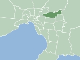
The City of Manningham is a Local Government Area in Victoria
, Australia
. It is located in the northeastern suburb
s of Melbourne
. The total population is 118,544 (2009), divided up into 10 suburb
s, the largest being Doncaster
and Templestowe
, over an area of 113 square kilometres.
The district spans a roughly east-west direction along the southern banks of the Yarra River
and across the undulating valleys of the Koonung
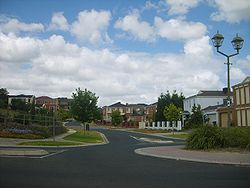
, Ruffey and Mullum Mullum Creeks, alternating from typical low density suburban housing in the west to remnant bushland within a green wedge in the east. As such, the district encompasses the transition between the built and natural environments in Melbourne's east and enjoys a "balance of city and country".
Formerly the City of Doncaster & Templestowe
, the district was originally part of the Wurundjeri
nation's territory. Most of the first European settlers to the area were orchardists, arriving through the 1850s. Gold was first discovered in Victoria around the same time at Andersons Creek
in Warrandyte, however, the district saw varied growth as periods of low density suburban development occurred sporadically throughout the mid-late 20th century.
Manningham has very high private automobile use due to low access to public transportation. Despite this, BankWest rated Manningham seventh of 590 Australian Local Government Areas in the BankWest Quality of Life Index 2008, second in Victoria.
was created on 15 December 1994 as part of a general restructure of Melbourne
's local government boundaries. The new municipality contains the former City of Doncaster & Templestowe
, but with Ringwood North
ceded to the new City of Maroondah, and with Wonga Park
annexed from the former Shire of Lillydale
.
The name Bulleen
, a nearby suburb, was proposed for the new municipality, as it was the name of the shire predating the City of Doncaster and Templestowe. Modern residents believed the name was too localised, so the name of one of the major roads was adopted. (Oddly, however, this road is localised, to the region between Bulleen
and Doncaster
.) The origin of Manningham Road's name is unconfirmed, but it would most likely be from the region of Bradford
, West Yorkshire
, England
, as the name Doncaster
is also from Yorkshire
. Residents requests for the City to be named after Indigenous Australian names local to the area such as Mullum Mullum or Koonung, were rejected.
 The main watercourses that border or flow through the City of Manningham include;
voters.
 Manningham was previously divided into four wards, each electing two councillors, but as of the November 2008 election, there are three wards (Ruffey Ward, incorporating Tempelstowe, was merged with Heide Ward; two of the new wards are named after creeks in the area) with three councillors for each ward. Anyone may stand as a candidate for election if entitled under the Local Government Act to be on the voters’ roll in respect of any ward of the council in which the election is being conducted, and they are qualified to become a councillor. Councillors are elected by residents in a postal ballot using the proportional representation system and hold office for a term of four years. The Victorian Electoral Commission lists elected councillors in the order in which they were elected.
Koonung Ward named after the Koonung Creek
Mullum Mullum Ward named after the Mullum Mullum Creek
Primary Schools - Private (9)
Secondary Colleges - Public (4)
Secondary Colleges - Private (3)
Other (1)
Libraries (4)
All libraries in the Manningham area are operated by the Whitehorse Manningham Regional Library Corporation who also have branches in Nunawading.
as its infrastructure was constructed throughout the mid-late 20th century. There is no train
or tram
transportation within the city council. A Doncaster East Train Line
had been planned for many decades, however the land was sold off in the 1980s. Residents have long campaigned for extension of the number 48
tram along Doncaster Road to Doncaster, East Doncaster or Donvale, although this is heavily supported by Local Governments and Councils, the issue is consistently avoided by State Government. There are increased bus services
to cope with the demand for public transport
, all mainly operated by National Bus Company
(sold to Ventura Bus Company) and only two bus routes are exclusive to Manningham that circle the area clockwise and counterclockwise to service destinations within the city council. Despite the increased bus services, the need for an appropriate method of transport is lacking.
41% of Manningham residents are classified as low income earners and a good proportion of their income goes into maintaining and fueling private automobiles.
Victoria (Australia)
Victoria is the second most populous state in Australia. Geographically the smallest mainland state, Victoria is bordered by New South Wales, South Australia, and Tasmania on Boundary Islet to the north, west and south respectively....
, Australia
Australia
Australia , officially the Commonwealth of Australia, is a country in the Southern Hemisphere comprising the mainland of the Australian continent, the island of Tasmania, and numerous smaller islands in the Indian and Pacific Oceans. It is the world's sixth-largest country by total area...
. It is located in the northeastern suburb
Suburb
The word suburb mostly refers to a residential area, either existing as part of a city or as a separate residential community within commuting distance of a city . Some suburbs have a degree of administrative autonomy, and most have lower population density than inner city neighborhoods...
s of Melbourne
Melbourne
Melbourne is the capital and most populous city in the state of Victoria, and the second most populous city in Australia. The Melbourne City Centre is the hub of the greater metropolitan area and the Census statistical division—of which "Melbourne" is the common name. As of June 2009, the greater...
. The total population is 118,544 (2009), divided up into 10 suburb
Suburb
The word suburb mostly refers to a residential area, either existing as part of a city or as a separate residential community within commuting distance of a city . Some suburbs have a degree of administrative autonomy, and most have lower population density than inner city neighborhoods...
s, the largest being Doncaster
Doncaster, Victoria
Doncaster is a suburb in Melbourne, Victoria, Australia, 15 km north-east from Melbourne's central business district. Its Local Government Area is the City of Manningham. At the 2006 Census, Doncaster had a population of 17,879....
and Templestowe
Templestowe, Victoria
"Templestowe" redirects here. For the Victorian Legislative Council Province, please see Templestowe Province.Templestowe is a suburb in Melbourne, Victoria, Australia, 17 km north-east from Melbourne's central business district. Its Local Government Area is the City of Manningham...
, over an area of 113 square kilometres.
The district spans a roughly east-west direction along the southern banks of the Yarra River
Yarra River
The Yarra River, originally Birrarung, is a river in east-central Victoria, Australia. The lower stretches of the river is where the city of Melbourne was established in 1835 and today Greater Melbourne dominates and influences the landscape of its lower reaches...
and across the undulating valleys of the Koonung
Koonung Creek
Koonung Creek is a small tributary of the Yarra River in Melbourne's east. The creek originates in Nunawading near Springvale Road, and flows to join the Yarra at the border between Ivanhoe East, Bulleen and Balwyn North. The place the two waterways meet forms the borders between these suburbs...
, Ruffey and Mullum Mullum Creeks, alternating from typical low density suburban housing in the west to remnant bushland within a green wedge in the east. As such, the district encompasses the transition between the built and natural environments in Melbourne's east and enjoys a "balance of city and country".
Formerly the City of Doncaster & Templestowe
City of Doncaster & Templestowe
The City of Doncaster & Templestowe was a Local Government Area located about east-northeast of Melbourne, the state capital of Victoria, Australia. The city covered an area of , and existed from 1915 until 1994...
, the district was originally part of the Wurundjeri
Wurundjeri
The Wurundjeri are a people of the Indigenous Australian nation of the Woiwurrung language group, in the Kulin alliance, who occupy the Birrarung Valley, its tributaries and the present location of Melbourne, Australia...
nation's territory. Most of the first European settlers to the area were orchardists, arriving through the 1850s. Gold was first discovered in Victoria around the same time at Andersons Creek
Andersons Creek
Andersons Creek is a creek in Warrandyte and Park Orchards, east of Melbourne, Victoria, Australia. It is a tributary of the Yarra River. For tens of thousands of years it was used as a food and tool source sustainably by the Wurundjeri people, Indigenous Australians of the Kulin nation, who spoke...
in Warrandyte, however, the district saw varied growth as periods of low density suburban development occurred sporadically throughout the mid-late 20th century.
Manningham has very high private automobile use due to low access to public transportation. Despite this, BankWest rated Manningham seventh of 590 Australian Local Government Areas in the BankWest Quality of Life Index 2008, second in Victoria.
History
Manningham municipalityMunicipality
A municipality is essentially an urban administrative division having corporate status and usually powers of self-government. It can also be used to mean the governing body of a municipality. A municipality is a general-purpose administrative subdivision, as opposed to a special-purpose district...
was created on 15 December 1994 as part of a general restructure of Melbourne
Melbourne
Melbourne is the capital and most populous city in the state of Victoria, and the second most populous city in Australia. The Melbourne City Centre is the hub of the greater metropolitan area and the Census statistical division—of which "Melbourne" is the common name. As of June 2009, the greater...
's local government boundaries. The new municipality contains the former City of Doncaster & Templestowe
City of Doncaster & Templestowe
The City of Doncaster & Templestowe was a Local Government Area located about east-northeast of Melbourne, the state capital of Victoria, Australia. The city covered an area of , and existed from 1915 until 1994...
, but with Ringwood North
Ringwood North, Victoria
Ringwood North is a suburb in Melbourne, Victoria, Australia, 25 km north-east from Melbourne's central business district. Its Local Government Area is the City of Maroondah...
ceded to the new City of Maroondah, and with Wonga Park
Wonga Park, Victoria
Wonga Park a locality within Greater Melbourne beyond the Melbourne metropolitan area Urban Growth Boundary, 29 km north-east from Melbourne's central business district. Its Local Government Area is the City of Manningham...
annexed from the former Shire of Lillydale
Shire of Lillydale
The Shire of Lillydale was a Local Government Area located about northeast of Melbourne, the state capital of Victoria, Australia. The shire covered an area of , and existed from 1856 until 1994....
.
The name Bulleen
Bulleen, Victoria
Bulleen is a suburb in Melbourne, Victoria, Australia, 12 km north-east from Melbourne's central business district. Its Local Government Area is the City of Manningham. At the 2006 Census, Bulleen had a population of 10,528.-Etymology:...
, a nearby suburb, was proposed for the new municipality, as it was the name of the shire predating the City of Doncaster and Templestowe. Modern residents believed the name was too localised, so the name of one of the major roads was adopted. (Oddly, however, this road is localised, to the region between Bulleen
Bulleen, Victoria
Bulleen is a suburb in Melbourne, Victoria, Australia, 12 km north-east from Melbourne's central business district. Its Local Government Area is the City of Manningham. At the 2006 Census, Bulleen had a population of 10,528.-Etymology:...
and Doncaster
Doncaster, Victoria
Doncaster is a suburb in Melbourne, Victoria, Australia, 15 km north-east from Melbourne's central business district. Its Local Government Area is the City of Manningham. At the 2006 Census, Doncaster had a population of 17,879....
.) The origin of Manningham Road's name is unconfirmed, but it would most likely be from the region of Bradford
Bradford
Bradford lies at the heart of the City of Bradford, a metropolitan borough of West Yorkshire, in Northern England. It is situated in the foothills of the Pennines, west of Leeds, and northwest of Wakefield. Bradford became a municipal borough in 1847, and received its charter as a city in 1897...
, West Yorkshire
West Yorkshire
West Yorkshire is a metropolitan county within the Yorkshire and the Humber region of England with a population of 2.2 million. West Yorkshire came into existence as a metropolitan county in 1974 after the passage of the Local Government Act 1972....
, England
England
England is a country that is part of the United Kingdom. It shares land borders with Scotland to the north and Wales to the west; the Irish Sea is to the north west, the Celtic Sea to the south west, with the North Sea to the east and the English Channel to the south separating it from continental...
, as the name Doncaster
Doncaster, Victoria
Doncaster is a suburb in Melbourne, Victoria, Australia, 15 km north-east from Melbourne's central business district. Its Local Government Area is the City of Manningham. At the 2006 Census, Doncaster had a population of 17,879....
is also from Yorkshire
Yorkshire
Yorkshire is a historic county of northern England and the largest in the United Kingdom. Because of its great size in comparison to other English counties, functions have been increasingly undertaken over time by its subdivisions, which have also been subject to periodic reform...
. Residents requests for the City to be named after Indigenous Australian names local to the area such as Mullum Mullum or Koonung, were rejected.
Geography
- Yarra RiverYarra RiverThe Yarra River, originally Birrarung, is a river in east-central Victoria, Australia. The lower stretches of the river is where the city of Melbourne was established in 1835 and today Greater Melbourne dominates and influences the landscape of its lower reaches...
- Mullum Mullum Creek
- Koonung CreekKoonung CreekKoonung Creek is a small tributary of the Yarra River in Melbourne's east. The creek originates in Nunawading near Springvale Road, and flows to join the Yarra at the border between Ivanhoe East, Bulleen and Balwyn North. The place the two waterways meet forms the borders between these suburbs...
- Ruffey Creek
- Anderson's Creek
- Jumping Creek
Federal electorate
The Federal electorate of Menzies covers much of the City of Manningham and part of the northern portion of the City of Maroondah. It has been held by the Federal Liberal party since 1984.State electorates
The City of Manningham encompasses 3 Victorian state electorates. All of which have been held predominantly by the Liberal party, although the seat of Warrandyte is home to an above average proportion of GreensAustralian Greens
The Australian Greens, commonly known as The Greens, is an Australian green political party.The party was formed in 1992; however, its origins can be traced to the early environmental movement in Australia and the formation of the United Tasmania Group , the first Green party in the world, which...
voters.
- Bulleen
- Doncaster
- Warrandyte
Wards & Councillors
- Heide Ward named after the Heide Museum of Modern Art
|
Bulleen, Victoria Bulleen is a suburb in Melbourne, Victoria, Australia, 12 km north-east from Melbourne's central business district. Its Local Government Area is the City of Manningham. At the 2006 Census, Bulleen had a population of 10,528.-Etymology:... Templestowe Lower, Victoria Templestowe Lower is a suburb in Melbourne, Victoria, Australia, 15 km north-east from Melbourne's central business district. It's Local Government Area is the City of Manningham... Templestowe, Victoria "Templestowe" redirects here. For the Victorian Legislative Council Province, please see Templestowe Province.Templestowe is a suburb in Melbourne, Victoria, Australia, 17 km north-east from Melbourne's central business district. Its Local Government Area is the City of Manningham... |
|
Doncaster, Victoria Doncaster is a suburb in Melbourne, Victoria, Australia, 15 km north-east from Melbourne's central business district. Its Local Government Area is the City of Manningham. At the 2006 Census, Doncaster had a population of 17,879.... |
|
Wonga Park, Victoria Wonga Park a locality within Greater Melbourne beyond the Melbourne metropolitan area Urban Growth Boundary, 29 km north-east from Melbourne's central business district. Its Local Government Area is the City of Manningham... Warrandyte, Victoria Warrandyte is a suburb in Melbourne, Victoria, Australia, 24 km north-east from Melbourne's central business district. Its Local Government Area is the City of Manningham... Park Orchards, Victoria Park Orchards is a suburb in Melbourne, Victoria, Australia, 23 km north-east from Melbourne's central business district. Its Local Government Area is the City of Manningham. At the 2006 Census, Park Orchards had a population of 3590.... Donvale, Victoria Donvale is a suburb in Melbourne, Victoria, Australia, 20 km east from Melbourne's central business district. Its Local Government Area is the City of Manningham. At the 2006 Census, Donvale had a population of 11,667... |
Suburbs
- BulleenBulleen, VictoriaBulleen is a suburb in Melbourne, Victoria, Australia, 12 km north-east from Melbourne's central business district. Its Local Government Area is the City of Manningham. At the 2006 Census, Bulleen had a population of 10,528.-Etymology:...
- DoncasterDoncaster, VictoriaDoncaster is a suburb in Melbourne, Victoria, Australia, 15 km north-east from Melbourne's central business district. Its Local Government Area is the City of Manningham. At the 2006 Census, Doncaster had a population of 17,879....
- Doncaster EastDoncaster East, VictoriaDoncaster East is a suburb in Melbourne, Victoria, Australia, 19 km north-east from Melbourne's central business district. Its Local Government Area is the City of Manningham...
- DonvaleDonvale, VictoriaDonvale is a suburb in Melbourne, Victoria, Australia, 20 km east from Melbourne's central business district. Its Local Government Area is the City of Manningham. At the 2006 Census, Donvale had a population of 11,667...
- Park OrchardsPark Orchards, VictoriaPark Orchards is a suburb in Melbourne, Victoria, Australia, 23 km north-east from Melbourne's central business district. Its Local Government Area is the City of Manningham. At the 2006 Census, Park Orchards had a population of 3590....
- TemplestoweTemplestowe, Victoria"Templestowe" redirects here. For the Victorian Legislative Council Province, please see Templestowe Province.Templestowe is a suburb in Melbourne, Victoria, Australia, 17 km north-east from Melbourne's central business district. Its Local Government Area is the City of Manningham...
- Templestowe LowerTemplestowe Lower, VictoriaTemplestowe Lower is a suburb in Melbourne, Victoria, Australia, 15 km north-east from Melbourne's central business district. It's Local Government Area is the City of Manningham...
- WarrandyteWarrandyte, VictoriaWarrandyte is a suburb in Melbourne, Victoria, Australia, 24 km north-east from Melbourne's central business district. Its Local Government Area is the City of Manningham...
- Warrandyte SouthWarrandyte South, VictoriaWarrandyte South is a locality within Greater Melbourne beyond the Melbourne metropolitan area Urban Growth Boundary, 24 km north-east from Melbourne's central business district. Its Local Government Area is the City of Manningham...
- Wonga ParkWonga Park, VictoriaWonga Park a locality within Greater Melbourne beyond the Melbourne metropolitan area Urban Growth Boundary, 29 km north-east from Melbourne's central business district. Its Local Government Area is the City of Manningham...
Populations
- Doncaster - 44,577
- Doncaster East - 26,698
- Doncaster - 17,879
- Templestowe - 29,448
- Templestowe - 16,428
- Templestowe Lower - 13,020
- Donvale - 11,667
- Bulleen - 10,528
- Warrandyte - 7,717
- Warrandyte - 7,393
- Warrandyte South - 324
- Park Orchards - 3,590
- Wonga Park - 3,505
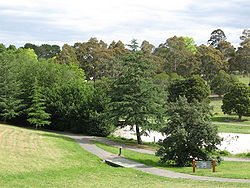
Parklands
Manningham hosts many parklands, many of those located in suburban areas were once cleared for agriculture such as orchards, while those found outside the suburbs contain remnant or regenerated natural vegetation. Some of the major parks, roughly in order of size, include;- Warrandyte State ParkWarrandyte State ParkWarrandyte State Park is a state park, located in Warrandyte, east of Melbourne, Victoria on the banks of the Yarra River and surroundings. The park comprises 586 hectares of remnant bushland in various locations throughout Warrandyte and Wonga Park around Pound Bend, Fourth Hill, Black Flat, Yarra...
- Warrandyte & Wonga ParkWonga Park, VictoriaWonga Park a locality within Greater Melbourne beyond the Melbourne metropolitan area Urban Growth Boundary, 29 km north-east from Melbourne's central business district. Its Local Government Area is the City of Manningham... - Westerfolds Park - TemplestoweTemplestowe, Victoria"Templestowe" redirects here. For the Victorian Legislative Council Province, please see Templestowe Province.Templestowe is a suburb in Melbourne, Victoria, Australia, 17 km north-east from Melbourne's central business district. Its Local Government Area is the City of Manningham...
- Candlebark Park - TemplestoweTemplestowe, Victoria"Templestowe" redirects here. For the Victorian Legislative Council Province, please see Templestowe Province.Templestowe is a suburb in Melbourne, Victoria, Australia, 17 km north-east from Melbourne's central business district. Its Local Government Area is the City of Manningham...
- Tikalara Park - TemplestoweTemplestowe, Victoria"Templestowe" redirects here. For the Victorian Legislative Council Province, please see Templestowe Province.Templestowe is a suburb in Melbourne, Victoria, Australia, 17 km north-east from Melbourne's central business district. Its Local Government Area is the City of Manningham...
- Ruffey Lake ParkRuffey Lake ParkRuffey Lake Park is a park in the City of Manningham, Melbourne, Victoria, Australia. It is situated around Ruffey Lake in a portion of a valley through which the Ruffey Creek runs, forming the border between Doncaster and Templestowe. It has 3 main entrances, Victoria St, The Boulevard and King St...
- DoncasterDoncaster, VictoriaDoncaster is a suburb in Melbourne, Victoria, Australia, 15 km north-east from Melbourne's central business district. Its Local Government Area is the City of Manningham. At the 2006 Census, Doncaster had a population of 17,879....
& TemplestoweTemplestowe, Victoria"Templestowe" redirects here. For the Victorian Legislative Council Province, please see Templestowe Province.Templestowe is a suburb in Melbourne, Victoria, Australia, 17 km north-east from Melbourne's central business district. Its Local Government Area is the City of Manningham... - Currawong Bush ParkCurrawong Bush ParkCurrawong Bush Park is an important riparian bushland park, located in the outer eastern suburbs of Melbourne on the borders of Doncaster East, Warrandyte and Donvale, on the eastern bank of the Mullum Mullum Creek...
- Warrandyte - Birrarung Park - Templestowe LowerTemplestowe Lower, VictoriaTemplestowe Lower is a suburb in Melbourne, Victoria, Australia, 15 km north-east from Melbourne's central business district. It's Local Government Area is the City of Manningham...
& BulleenBulleen, VictoriaBulleen is a suburb in Melbourne, Victoria, Australia, 12 km north-east from Melbourne's central business district. Its Local Government Area is the City of Manningham. At the 2006 Census, Bulleen had a population of 10,528.-Etymology:... - Buck Reserve - DonvaleDonvale, VictoriaDonvale is a suburb in Melbourne, Victoria, Australia, 20 km east from Melbourne's central business district. Its Local Government Area is the City of Manningham. At the 2006 Census, Donvale had a population of 11,667...
- The 100 Acres - Park OrchardsPark Orchards, VictoriaPark Orchards is a suburb in Melbourne, Victoria, Australia, 23 km north-east from Melbourne's central business district. Its Local Government Area is the City of Manningham. At the 2006 Census, Park Orchards had a population of 3590....
- Mullum Mullum Creek Linear ParkMullum Mullum Creek Linear ParkThe Mullum Mullum Creek Linear Park is located east of Melbourne, Australia in the suburbs of Doncaster East and Donvale. It streaches for roughly 3 km along the western banks of the Mullum Mullum Creek between Heidelberg-Warrandyte Road and Tindals Road. Facilities include sealed pathways,...
- Doncaster EastDoncaster East, VictoriaDoncaster East is a suburb in Melbourne, Victoria, Australia, 19 km north-east from Melbourne's central business district. Its Local Government Area is the City of Manningham...
& DonvaleDonvale, VictoriaDonvale is a suburb in Melbourne, Victoria, Australia, 20 km east from Melbourne's central business district. Its Local Government Area is the City of Manningham. At the 2006 Census, Donvale had a population of 11,667...
Education
Primary Schools - Public (14)- Andersons Creek Primary School, Warrandyte
- Warrandyte Primary School, Warrandyte
- Templestowe Heights Primary School, Templestowe
- Templestowe Park Primary School, Templestowe
- Templestowe Valley Primary School, Templestowe
- Serpell Primary School, Templestowe
- Birralee Primary School, Doncaster
- Doncaster Primary School, Doncaster
- Doncaster Gardens Primary School, Doncaster
- Milgate Primary School, Doncaster East
- Donburn Primary School, Doncaster East
- Beverley Hills Primary School, Doncaster East
- Donvale Primary School, Donvale
- Park Orchards Primary School, Park Orchards
Primary Schools - Private (9)
- St Clement of Rome Catholic Primary School, Bulleen http://www.clement.melb.catholic.edu.au/
- St Gregory the Great Catholic Primary School, Doncaster http://www.sgdoncaster.catholic.edu.au/
- Ss Peter & Paul's Catholic Primary School, Doncaster East http://www.sppdcstr.catholic.edu.au/
- Carey Baptist Grammar SchoolCarey Baptist Grammar SchoolCarey Baptist Grammar School is an independent, co-educational, Christian, international, day school consisting of four campuses in Victoria, Australia - Kew , Donvale , the Carey Sports Complex in Bulleen and an outdoor education camp near Paynesville in eastern Gippsland called Carey...
, Donvale - Our Lady of the Pines Catholic Primary School, Donvale http://www.olopdonvale.catholic.edu.au/
- St Anne's Catholic Primary School, Park Orchards http://www.sannpark.melb.catholic.edu.au/
- St Charles Borromeo Catholic Primary School, Templestowe http://www.scbtemplestowe.catholic.edu.au/
- St Kevin's Catholic Primary School, Templestowe http://skvntstw.melb.catholic.edu.au/
Secondary Colleges - Public (4)
- Doncaster Secondary CollegeDoncaster Secondary CollegeDoncaster Secondary College is a secondary school located in the Melbourne suburb of Doncaster.Founded on 5 February 1969, the school adopts a non-selective enrolment policy and caters for over 1300 students from Year 7 to 12 - making it the largest high school in the city of Manningham...
, Doncaster - East Doncaster Secondary CollegeEast Doncaster Secondary CollegeEast Doncaster Secondary College is a government high school in the Melbourne suburb of Doncaster East. It is located on George Street and was established in 1974. Its current principal is John Handley. East Doncaster Secondary College is a co-educational school and has over 1500 students. This...
, Doncaster East - Templestowe College, Templestowe
- Warrandyte High SchoolWarrandyte High SchoolWarrandyte High School is a high school in Warrandyte, Victoria, Australia. Established as only a few portable classrooms in 1978, it now comprises two main buildings and many semi-permanent portables set amongst many types of eucalyptus, native wildlife and other native vegetation, on a hillside...
, Warrandyte
Secondary Colleges - Private (3)
- Marcellin CollegeMarcellin CollegeMarcellin College is a Marist Catholic secondary boys' school situated in Bulleen, Victoria, Australia.The school was founded in 1950 by the Marist Brothers originally in Camberwell...
, Bulleen - Whitefriars CollegeWhitefriars CollegeWhitefriars College is a Roman Catholic Independent school for boys located in the Melbourne suburb of Donvale. Established in 1961, the College reflects the tradition of the Carmelites, and is recognised for its uniform's brown blazer with the College Crest appearing on the breast pocket...
, Donvale - Donvale Christian College, Donvale
Other (1)
- Bulleen Special School, Bulleen
Libraries (4)
All libraries in the Manningham area are operated by the Whitehorse Manningham Regional Library Corporation who also have branches in Nunawading.
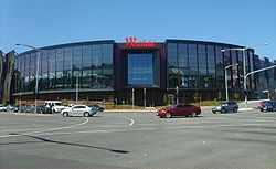
- Doncaster Library - currently a portable building. Previously located at Westfield DoncasterWestfield DoncasterWestfield Doncaster is a shopping centre 50% owned by the Westfield Group and 50% owned by LaSalle Investment Management located in Doncaster, a suburb of Melbourne, Victoria, Australia...
. Will be permanently located in the new Doncaster HillDoncaster HillDoncaster Hill is one of the highest points in the metropolitan area of Melbourne, Australia. Located in the suburb of Doncaster, it is 120 metres above sea level and has uninterrupted views of the city, Port Phillip, Macedon Ranges, the You Yang Ranges and Dandenong Ranges...
Council precinct. - The Pines Library - located next to Stockland The Pines Shopping Centre.
- Warrandyte Library
- Bulleen Library - located next to Bulleen PlazaBulleen PlazaBulleen Plaza, is a local shopping centre in the suburb of Bulleen, Victoria, in the city council of Manningham. During mid-2008, the centre underwent a revamp and was repainted, retiled and new lights and seats were fitted....
.
Transport
Transport in Manningham is heavily reliant on the private automobileČar
Čar is a village in the municipality of Bujanovac, Serbia. According to the 2002 census, the town has a population of 296 people.-References:...
as its infrastructure was constructed throughout the mid-late 20th century. There is no train
Train
A train is a connected series of vehicles for rail transport that move along a track to transport cargo or passengers from one place to another place. The track usually consists of two rails, but might also be a monorail or maglev guideway.Propulsion for the train is provided by a separate...
or tram
Tram
A tram is a passenger rail vehicle which runs on tracks along public urban streets and also sometimes on separate rights of way. It may also run between cities and/or towns , and/or partially grade separated even in the cities...
transportation within the city council. A Doncaster East Train Line
Doncaster railway line, Melbourne
The Doncaster railway line is a proposed suburban railway in the eastern suburbs of Melbourne, Victoria, Australia. Connecting to the existing Melbourne metro railway network at Victoria Park station on the Epping and Hurstbridge lines; the Doncaster line would have served the suburbs of Bulleen,...
had been planned for many decades, however the land was sold off in the 1980s. Residents have long campaigned for extension of the number 48
Melbourne tram route 48
Tram route 48 is a public transport service in Melbourne, Victoria, Australia. It runs from Victoria Harbour, Docklands to North Balwyn via Collins Street, Spring Street, Wellington Parade and Bridge Road...
tram along Doncaster Road to Doncaster, East Doncaster or Donvale, although this is heavily supported by Local Governments and Councils, the issue is consistently avoided by State Government. There are increased bus services
Transport in Melbourne
Transport in Melbourne consists of extensive networks and a wide variety of transport services in the city of Melbourne, Australia, including:* The world's largest tram network.* Bus and coach services...
to cope with the demand for public transport
Public transport
Public transport is a shared passenger transportation service which is available for use by the general public, as distinct from modes such as taxicab, car pooling or hired buses which are not shared by strangers without private arrangement.Public transport modes include buses, trolleybuses, trams...
, all mainly operated by National Bus Company
National Bus Company
The National Bus Company, or NBC, was the Australian brand for National Express Group's mass transit bus services in Melbourne and Brisbane. Its sister companies were Westbus, Hillsbus, and Glenorie in Sydney, Southern Coast Transit in Perth.-Routes:...
(sold to Ventura Bus Company) and only two bus routes are exclusive to Manningham that circle the area clockwise and counterclockwise to service destinations within the city council. Despite the increased bus services, the need for an appropriate method of transport is lacking.
41% of Manningham residents are classified as low income earners and a good proportion of their income goes into maintaining and fueling private automobiles.
Major Roadways
- Andersons Creek Road

- Blackburn Road
- Bulleen Road

- Croydon Road

- Doncaster Road


- Eastern Freeway

- Elgar Road
- High Street
- Fitzsimons Lane

- Foote Street

- King Street
- Jumping Creek Road
- Manningham Road
- Mitcham Road
- Northern Route:
- Reynolds Road
- Tindals Road
- Falconer Road
- Stintons Road
- Reynolds Road
- Park Road
- Springvale Road
- Templestowe Road
- Thompsons Road
- Tram Road
- Warrandyte Road:
- Heidelberg-Warrandyte Road
- Warrandyte-Ringwood Road

- Heidelberg-Warrandyte Road
- Wetherby Road

- Williamsons Road