
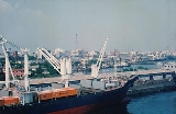
Chennai Port
Encyclopedia
India
India , officially the Republic of India , is a country in South Asia. It is the seventh-largest country by geographical area, the second-most populous country with over 1.2 billion people, and the most populous democracy in the world...
, behind the Mumbai Port, and the largest port in the Bay of Bengal
Bay of Bengal
The Bay of Bengal , the largest bay in the world, forms the northeastern part of the Indian Ocean. It resembles a triangle in shape, and is bordered mostly by the Eastern Coast of India, southern coast of Bangladesh and Sri Lanka to the west and Burma and the Andaman and Nicobar Islands to the...
. Being the third oldest port among the 12 major ports of India, it is over 125 years old, although maritime trade started way back in 1639 on the sea shore. It is an artificial and all-weather port with wet docks. It was a major travel port before becoming a major container port. It is a substantial reason for the economic growth of Tamil Nadu
Tamil Nadu
Tamil Nadu is one of the 28 states of India. Its capital and largest city is Chennai. Tamil Nadu lies in the southernmost part of the Indian Peninsula and is bordered by the union territory of Pondicherry, and the states of Kerala, Karnataka, and Andhra Pradesh...
, especially for the manufacturing boom in South India
South India
South India is the area encompassing India's states of Andhra Pradesh, Karnataka, Kerala and Tamil Nadu as well as the union territories of Lakshadweep and Pondicherry, occupying 19.31% of India's area...
, and has contributed in no small measure to the development of the city. It is due of the existence of the port that the city of Chennai
Chennai
Chennai , formerly known as Madras or Madarasapatinam , is the capital city of the Indian state of Tamil Nadu, located on the Coromandel Coast off the Bay of Bengal. Chennai is the fourth most populous metropolitan area and the sixth most populous city in India...
became known as the Gateway of South India. The port with 3 docks, 24 berths and draft ranging from 12 metre has become a hub port for containers, cars and project cargo in the east coast of India. From handling a meagre volume of cargo in the early years, consisting chiefly of imports of oil and motors and the export of groundnuts, granite and ores, the port has moved towards handling 60 million tonnes of cargo in recent years. An ISO 14001:2004 and ISPS-certified port, its container traffic crossed 1 million twenty-foot equivalent units (TEUs) for the first time in 2008. It is currently ranked the 86th largest container port in the world and is expanding in the coming years with the capacity going up to 140 million tonnes per annum. Chennai Port has been transformed into a main line port having direct connectivity to 50+ ports.
History
Before 1800sAlthough the settlement of Madras did not form until after the mid-17th century, the region surrounding the present-day port remained an important centre for military, administrative, and economic activities since the 1st century AD under various South Indian dynasties, namely, the Pallava
Pallava
The Pallava dynasty was a Tamil dynasty which ruled the northern Tamil Nadu region and the southern Andhra Pradesh region with their capital at Kanchipuram...
, the Pandya, the Chola, and the Vijayanagara
Vijayanagara Empire
The Vijayanagara Empire , referred as the Kingdom of Bisnaga by the Portuguese, was an empire based in South Indian in the Deccan Plateau region. It was established in 1336 by Harihara I and his brother Bukka Raya I of the Yadava lineage. The empire rose to prominence as a culmination of attempts...
empires. Chief among them was the Pallava dynasty, which reigned from the 6th to 9th centuries AD. The ancient town of Mylapore
Mylapore
Mylapore is a cultural hub and neighborhood in the southern part of the city of Chennai, the capital of Tamil Nadu, India. Earlier, Mylapore used to be called Vedapuri....
, known to Roman traders as "Meliapor", was an important port of the Pallavas and is now part of Chennai.
The region also attracted many distant civilisations, with the Christian
Christian
A Christian is a person who adheres to Christianity, an Abrahamic, monotheistic religion based on the life and teachings of Jesus of Nazareth as recorded in the Canonical gospels and the letters of the New Testament...
apostle
Apostle
An apostle is a messenger and ambassador.Apostle and apostles may refer to:-Religion:* Apostle , one of the Twelve Apostles of Jesus Christ, named in the New Testament...
St. Thomas
Thomas the Apostle
Thomas the Apostle, also called Doubting Thomas or Didymus was one of the Twelve Apostles of Jesus. He is best known for questioning Jesus' resurrection when first told of it, then proclaiming "My Lord and my God" on seeing Jesus in . He was perhaps the only Apostle who went outside the Roman...
having preached in the area between 52 and 70 AD. In 1522, the Portuguese
Portugal
Portugal , officially the Portuguese Republic is a country situated in southwestern Europe on the Iberian Peninsula. Portugal is the westernmost country of Europe, and is bordered by the Atlantic Ocean to the West and South and by Spain to the North and East. The Atlantic archipelagos of the...
built the São Tomé harbour, named after St. Thomas, on the site of today's port and the São Tomé church on the grave of Saint Thomas. The following years saw the arrival of other Europeans, namely, the Dutch
Dutch people
The Dutch people are an ethnic group native to the Netherlands. They share a common culture and speak the Dutch language. Dutch people and their descendants are found in migrant communities worldwide, notably in Suriname, Chile, Brazil, Canada, Australia, South Africa, New Zealand, and the United...
arriving at Pulicat
Pulicat
Pulicat is a historic seashore town in Thiruvallur District, of Tamil Nadu state, South India. It is about 60 km north of Chennai and 3 km from Elavur, on the barrier island of Sriharikota, which separates Pulicat Lake from the Bay of Bengal. Pulicat lake is a shallow salt water lagoon...
in 1613 and the British
United Kingdom
The United Kingdom of Great Britain and Northern IrelandIn the United Kingdom and Dependencies, other languages have been officially recognised as legitimate autochthonous languages under the European Charter for Regional or Minority Languages...
arriving in 1639. In 1639, the British East India Company
British East India Company
The East India Company was an early English joint-stock company that was formed initially for pursuing trade with the East Indies, but that ended up trading mainly with the Indian subcontinent and China...
bought a three-mile long strip of land lying along the coast between the Cooum delta and the Egmore River encompassing an area of about five square kilometres from the Vijayanagara King Peda Venkata Rayalu. Soon obtaining permission from the regional ruler, Damarla Venkatadri Nayakudu, the British built a warehouse and factory on the site, and in 1940, the British expanded the occupation by building the Fort St. George and establishing a colony on the site of the future port of Madras.
In 1746, under the leadership of Admiral La Bourdonnais
Bertrand-François Mahé de La Bourdonnais
Bertrand-François Mahé de La Bourdonnais was a French naval officer and administrator, in the service of the French East India Company.-Biography:...
, French
France
The French Republic , The French Republic , The French Republic , (commonly known as France , is a unitary semi-presidential republic in Western Europe with several overseas territories and islands located on other continents and in the Indian, Pacific, and Atlantic oceans. Metropolitan France...
forces captured and plundered Madras, the fort and surrounding villages. However, they returned the town along with the port to the British under the Treaty of Aix-la-Chapelle
Treaty of Aix-la-Chapelle (1748)
The Treaty of Aix-la-Chapelle of 1748 ended the War of the Austrian Succession following a congress assembled at the Imperial Free City of Aachen—Aix-la-Chapelle in French—in the west of the Holy Roman Empire, on 24 April 1748...
in 1748. The British then strengthened the fort to defend the port not only from the French but also from the increasingly powerful Sultan of Mysore
Tipu Sultan
Tipu Sultan , also known as the Tiger of Mysore, was the de facto ruler of the Kingdom of Mysore. He was the son of Hyder Ali, at that time an officer in the Mysorean army, and his second wife, Fatima or Fakhr-un-Nissa...
and other regional rulers.
The British era
By the late 18th century, most of the southern region of India had been conquered by the British
United Kingdom
The United Kingdom of Great Britain and Northern IrelandIn the United Kingdom and Dependencies, other languages have been officially recognised as legitimate autochthonous languages under the European Charter for Regional or Minority Languages...
and Madras was established as the capital of the Madras Presidency
Madras Presidency
The Madras Presidency , officially the Presidency of Fort St. George and also known as Madras Province, was an administrative subdivision of British India...
. During this period, the port flourished under British rule, becoming an important naval base and urban center. A port at Madras was first suggested by Warren Hastings
Warren Hastings
Warren Hastings PC was the first Governor-General of India, from 1773 to 1785. He was famously accused of corruption in an impeachment in 1787, but was acquitted in 1795. He was made a Privy Councillor in 1814.-Early life:...
in 1770 when he was posted here, who later became the first Governor General of India. However, it was not until the 1850s that work began on a pier to berth vessels following suggestions from the Madras Chamber of Commerce and Industry. Till 1815, it was an open roadstead and exposed sandy coast, swept by occasional storms and monsoons. At the time, the natural harbor was so shallow that ships had to anchor over 1 km (0.621372736649807 mi) offshore, and cargo was delivered to and from the shore in masula boats and catamarans. Cargo losses were high, and a 335 m (1,099.1 ft) iron-screw pile pier
Pier
A pier is a raised structure, including bridge and building supports and walkways, over water, typically supported by widely spread piles or pillars...
capable of berthing larger vessels was built perpendicular to the shore in 1861. However, the storms of 1868 and 1872 made the initial piers inoperative. So the masonry work for L-shaped breakwaters was started in 1876. In 1877, construction of the south pier was commenced with stones brought from Pallavaram
Pallavaram
Pallavapuram Municipality was constituted as a III Grade Municipality on 17.01.1970 vide G.o.No. 55 R.D. & L.A. Department dated 12.01.1970, by Combining the following Town Panchayats and Panchayats.* Zamin Pallavaram Town Panchayat* Issa Pallavaram Town Panchayat...
, and the port started handling ships inside the harbour from 1881. However, again the storm of 12 November 1881 completely washed the almost-completed harbour, breaching over half a mile of breakwater. An artificial harbour was then built and the operations were started in 1881, and the pier was rebuilt in 1885, although there was a demand for relocating the entrance. Work on the harbour was completed in 1911. The Chennai Port Trust has taken the year 1881, the year of rebuilding, as the starting year. The cargo operations were carried out on the northern pier, located on the northeastern side of Fort St. George in Chennai. In the first couple of years the port registered traffic of 300,000 tonnes of cargo handling 600 ships. The first railway line in South India was laid between Madras and Arcot which started operating in 1856. By the late 19th century, the port was well connected to the other two important cities in the British colony, viz. Bombay (Mumbai
Mumbai
Mumbai , formerly known as Bombay in English, is the capital of the Indian state of Maharashtra. It is the most populous city in India, and the fourth most populous city in the world, with a total metropolitan area population of approximately 20.5 million...
) and Calcutta (Kolkata
Kolkata
Kolkata , formerly known as Calcutta, is the capital of the Indian state of West Bengal. Located on the east bank of the Hooghly River, it was the commercial capital of East India...
). In 1904, a new northeastern entrance was added to control siltation in the basin, after closing the original eastern entrance. The port's quays (berths) were constructed at different periods—the South Quay I in 1913, the five west quay berths between 1916 and 1920, the north quay in 1931 and the South Quay II in 1936, in the Inner Harbour, later christened Dr. Ambedkar Dock. Chennai was the only Indian city to be attacked
Bombardment of Madras
The Bombardment of Madras was an engagement of World War I, at Madras in British India, now the modern day Chennai. The bombardment was initiated by the German light cruiser Emden at the start of the war in 1914....
by the Central Powers
Triple Alliance (1882)
The Triple Alliance was the military alliance between Germany, Austria–Hungary, and Italy, , that lasted from 1882 until the start of World War I in 1914...
during World War I
World War I
World War I , which was predominantly called the World War or the Great War from its occurrence until 1939, and the First World War or World War I thereafter, was a major war centred in Europe that began on 28 July 1914 and lasted until 11 November 1918...
when a German
Germany
Germany , officially the Federal Republic of Germany , is a federal parliamentary republic in Europe. The country consists of 16 states while the capital and largest city is Berlin. Germany covers an area of 357,021 km2 and has a largely temperate seasonal climate...
cruiser, SMS Emden
SMS Emden
SMS Emden was a light cruiser of the Imperial German Navy in World War I. The Emden raided Allied shipping in the Indian Ocean early in the war, sinking or capturing thirty Allied merchant vessels and warships before being run aground by her captain to prevent her from sinking, after engaging the...
, shelled the oil depot within the port belonging to the Burmah Oil Company and raided vessels in 1914 disrupting trade, resulting in the death of at least 5 sailors. The port was also the only operational one in eastern waters during the Second World War. In 1911, the Royal Madras Yacht Club (RMYC), which is based within the Chennai Port premises, was founded by Sir Francis Dallas Rafold Spring, the first chairman on the Madras Port Trust who was responsible for Chennai becoming a trading hub, especially during World War II. In 1916, the harbour office building was constructed.
From 1905 to 1919, major improvements took place in the port under the stewardship of the visionary Sir Francis Spring. Being an artificial harbour, the port was vulnerable to cyclone
Cyclone
In meteorology, a cyclone is an area of closed, circular fluid motion rotating in the same direction as the Earth. This is usually characterized by inward spiraling winds that rotate anticlockwise in the Northern Hemisphere and clockwise in the Southern Hemisphere of the Earth. Most large-scale...
s and accretion of sand inside the basin due to underwater currents
Ocean current
An ocean current is a continuous, directed movement of ocean water generated by the forces acting upon this mean flow, such as breaking waves, wind, Coriolis effect, cabbeling, temperature and salinity differences and tides caused by the gravitational pull of the Moon and the Sun...
, which reduced the draft. To charter the course of the port development, Sir Francis Spring, who assumed charge as the chief engineer of the port in 1906, drew a long-term plan in a scientific manner to overcome challenges, both artificial and natural. The shifting of the entrance of the port from eastern side to the northeastern side protected the port to a large extent from the natural vulnerabilities. By the end of 1920, the port had a dock consisting of four berths in the west quays, one each in the east and south quay along with the transit sheds, warehouses and a marshalling yard to facilitate the transfer of cargo from land to sea and vice versa. In 1929, the Mercantile Marine Department, which was working directly under the Ministry of Shipping till the establishment of the Directorate General of Shipping at Mumbai in 1949, was established to implement the first SOLAS and Load Line conventions. Additional berths were added in the 1940s with a berth at south quay and another between WQ2 and WQ3. The year 1946 saw the establishment of the Port Health Organisation. In 1947, when India gained independence, Chennai became the capital of the Madras State
Madras State
Madras State was the name by which the Indian districts in Tamil Nadu, Andhra, Northern Kerala, Bellary and Dakshina Kannada were collectively known as from 1950 to 1953....
, renamed as Tamil Nadu
Tamil Nadu
Tamil Nadu is one of the 28 states of India. Its capital and largest city is Chennai. Tamil Nadu lies in the southernmost part of the Indian Peninsula and is bordered by the union territory of Pondicherry, and the states of Kerala, Karnataka, and Andhra Pradesh...
in 1969.
Post-Independence
Post-Independence, the development of the port gained momentum. In 1959, a passenger station on the first floor of the transit shed at north quay was commissioned. In 1961, construction of signal station at north quay was completed. In the same year, the port's Jawahar Dock was inaugurated by the then prime minister of India, Lal Bahadur Shastri
Lal Bahadur Shastri
Lal Bahadur Srivastava Shastri was the second Prime Minister of the Republic of India and a significant figure in the Indian independence movement.-Early life:...
. In 1964, the Jawahar dock with capacity to berth 6 vessels to handle dry bulk cargoes such as coal, iron ore, fertilizer and non-hazardous liquid cargoes was created on the southern side changing the topography of the port. To handle vessels with as much as 16.2 m (53.1 ft) draft, the port developed the outer harbour, named Bharathi Dock, for handling petroleum in 1972 and for mechanized handling of iron ore in 1974. In 1972, the first oil jetty was constructed at Bharathi Dock-I capable of handling tankers up to 100,000 DWT to handle imports of crude oil destined for the Manali Oil Refinery (later named the Chennai Petroleum Corporation Limited). In 1974, the iron ore berth was added to the port for exports to Japan
Japan
Japan is an island nation in East Asia. Located in the Pacific Ocean, it lies to the east of the Sea of Japan, China, North Korea, South Korea and Russia, stretching from the Sea of Okhotsk in the north to the East China Sea and Taiwan in the south...
and other countries in the Far East. The second oil jetty was added at Bharathi Dock-III in 1986 capable of handling tankers up to 140,000 DWT to meet increasing demands for crude oil and petroleum products. The iron ore terminal is equipped with mechanized ore-handling plant commissioned in 1977 at Bharathi Dock-II capable of handling ore carriers of maximum size 1,45,000 DWT, one of the three such facility in the country, with a capacity of handling 8 million tonnes and a loading rate of 6,000 tonnes per hour. The port's share of iron ore export from India is 12 per cent. The dedicated facility for oil led to the development of oil refinery in the hinterland. This oil terminal is capable of handling Suezmax
Suezmax
Suezmax is a naval architecture term for the largest ship measurements capable of transiting the Suez Canal, and is almost exclusively used in reference to tankers. Since the canal has no locks, the only serious limiting factors are draft , and height due to the Suez Canal Bridge...
vessels.
In the 1970s, containerisation started in India in a limited way with the creation of interim container handling facilities at Mumbai and Cochin ports in 1973. During the same period, Chennai Port began handling containerized cargoes. In 1983, a container terminal was built at the Bharathi Dock with a 380 metres (1,246.7 ft) quay, a 51000 square metres (60,995.5 sq yd) container yard, and a 6000 square metres (7,175.9 sq yd) container freight station, which was commissioned by the then prime minister Indira Gandhi
Indira Gandhi
Indira Priyadarshini Gandhara was an Indian politician who served as the third Prime Minister of India for three consecutive terms and a fourth term . She was assassinated by Sikh extremists...
on 18 December 1983 as the country's first dedicated container terminal facility. The terminal was provided with tow-shore cranes and other shore facilities. In 1991, the port's container terminal quay was lengthened by 220 m (721.8 ft) with two additional tow shore cranes. In November 2001, the container terminal and back-up area was privatized through a 30-year concession with Chennai Container Terminal Private Limited. Continually increasing container traffic resulted in another 285 metres (935 ft) extension of the quay in 2002, bringing the total berth length to 885 metres (2,903.5 ft). During 2008-09, the port recorded a 17.2% share of container traffic in India. Having the capability of handling fourth-generation vessels, the terminal is ranked among the top 100 container ports in the world. To meet the demand in container handling, the port is added with the second container terminal with a capacity to handle 1.5 million TEUs. The port is also planning a mega container terminal, capable of handling 4 million TEUs per annum expected to be operational from 2013, when the first phase of the project will be completed. The full project will be completed by 2017.
When the city of Madras was renamed as Chennai in 1996, the Madras Port Trust followed suit and was renamed as Chennai Port Trust. In 2000, the port began to handle pure-car-carrier shipments of automobiles. In 2003, the 200 m naval berth was given for 30-year lease. The 2004 tsunami devastated the shores of the port, taking many lives and permanently altering the coastline.
Location and geography
| Tide | Height (m) |
|---|---|
| Highest high water | 1.50 |
| Mean high water spring | 1.10 |
| Mean high water neap | 0.80 |
| Mean sea level | 0.54 |
| Mean low water neap | 0.40 |
| Mean low water spring | 0.10 |
| Mean spring range | 1.00 |
| Mean neap range | 0.40 |
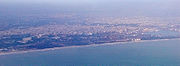
Chennai Port lies on a flat coastal plain known as the Eastern Coastal Plains
Eastern Coastal Plains
The Eastern Coastal Plains refer to a wide stretch of landmass of India, lying between the Eastern Ghats and the Bay of Bengal. It stretches from Tamil Nadu in the south to West Bengal in the north....
on the east coast of the Indian peninsula
Indian subcontinent
The Indian subcontinent, also Indian Subcontinent, Indo-Pak Subcontinent or South Asian Subcontinent is a region of the Asian continent on the Indian tectonic plate from the Hindu Kush or Hindu Koh, Himalayas and including the Kuen Lun and Karakoram ranges, forming a land mass which extends...
known as the Coromandel Coast
Coromandel Coast
The Coromandel Coast is the name given to the southeastern coast of the Indian Subcontinent between Cape Comorin and False Divi Point...
in the Bay of Bengal
Bay of Bengal
The Bay of Bengal , the largest bay in the world, forms the northeastern part of the Indian Ocean. It resembles a triangle in shape, and is bordered mostly by the Eastern Coast of India, southern coast of Bangladesh and Sri Lanka to the west and Burma and the Andaman and Nicobar Islands to the...
. The port is situated on the thermal equator
Thermal equator
The thermal equator is a belt encircling the Earth, defined by the set of locations having the highest mean annual temperature at each longitude around the globe...
and is also coastal, which prevents extreme variation in seasonal temperature. The climate is tropical, specifically tropical wet and dry
Tropical savanna climate
Tropical savanna climate or tropical wet and dry climate is a type of climate that corresponds to the Köppen climate classification categories "Aw" and '"As."...
, and for most of the year, the weather is hot and humid, with temperatures ranging from a maximum of 42°C in May to a minimum of 18°C in January. The port gets most of its seasonal rainfall from the northeast monsoon winds, from mid-September to mid-December. Occasionally, cyclones in the Bay of Bengal hit the coast. The annual rainfall in the region is about 1250 mm, and the spring tides are up to 1.2 m (3.9 ft). The mean tidal range varies from 0.914 m to 1.219 m at spring and from 0.805 m to 0.610 m at neap tides. The change in water levels combined due to astronomical tide, wind setup, wave setup
Wave setup
In fluid dynamics, wave setup is the change in mean water level due to the presence of waves. This setup is primarily present in and near the coastal surf zone...
, barometric pressure, seiches and global sea level rise are estimated as 1.57 m, 1.68 m and 1.8 m at 15 m, 10 m and 5 m depth contours, respectively.
The most prevailing winds in the region are the southwesterly between April and October and the northeasterly during the rest of the year. Situated on a coast that constitutes chiefly of sandy shelving breaker-swept beaches, the region surrounding the port falls under Seismic Zone III
Seismic hazard
Seismic hazard refers to the study of expected earthquake ground motions at the earth's surface, and its likely effects on existing natural conditions and man-made structures for public safety considerations; the results of such studies are published as seismic hazard maps, which identify the...
indicating a moderate risk of earthquake
Earthquake
An earthquake is the result of a sudden release of energy in the Earth's crust that creates seismic waves. The seismicity, seismism or seismic activity of an area refers to the frequency, type and size of earthquakes experienced over a period of time...
. The port was developed into the sea by reclaiming land as there is no sheltered harbour. The depth of the draft
Draft (hull)
The draft of a ship's hull is the vertical distance between the waterline and the bottom of the hull , with the thickness of the hull included; in the case of not being included the draft outline would be obtained...
is up to 17 m, and the soil in the entrance channel is predominantly sandy and silt. The port is bordered by the Cooum delta in the south and Royapuram fishing harbour
Royapuram fishing harbour
Royapuram fishing harbour, also known as Chennai fishing harbour, is one of the major fishing grounds for catching fishes and crustaceans located at Kasimedu in the Royapuram area of Chennai, India. Located north of the Chennai Port, the harbour was constructed in 1975...
in the north.
Historically, the port was responsible for the shoreline changes in the region, where the area south of the port has accreted significantly, resulting in the formation of the Marina Beach
Marina Beach
Marina Beach is a beach in the city of Chennai , India, along the Bay of Bengal, part of the Indian Ocean. The beach runs from near Fort St. George in the north to Besant Nagar in the south, a distance of , making it the longest urban beach in the country and the world's second longest...
, whereas the coast in the northern region has undergone severe erosion. Ever since the harbour was constructed, the coast north of the harbour has been experiencing erosion at the rate of about 8 m annually. The shoreline has recessed by about 1,000 m with respect to the original shoreline in 1876. It is estimated that 500 m of beach has been lost between 1876 and 1975 and another 200 m between 1978 and 1995. About 350 ha land in the coast north of the port is lost into sea. On the other hand, the area south of the port is increasing 40 sq m every year due to the progradation
Progradation
In sedimentary geology and geomorphology, the term progradation refers to the growth of a river delta farther out into the sea over time. This occurs when the mass balance of sediment into the delta is such that the volume of incoming sediment is greater than the volume of the delta that is lost...
.
Traffic growth
| Year | Cargo (million tonnes) |
|---|---|
| 2001-02 | 36.1 |
| 2002-03 | 33.6 |
| 2003-04 | 36.71 |
| 2004-05 | 43.81 |
| 2005-06 | 47.25 |
| 2006-07 | 53.41 |
| 2007-08 | 57.15 |
| 2008-09 | 57.49 |
| 2009-10 | 61.06 |
| 2010-11 | 61.46 |
From 1881 to 1945, the cargo handled in Madras port varied from 0.5 million tonnes to 1 million tonnes. By 1979-80, the traffic touched 10 million tonnes and increased to 15 million tonnes in 1984-85. By 1991-92, the volume was 25 million tonnes, touching 41 million tonnes in 2000-01. Though there was a slump in the next three years, mainly due to the transfer of about 9 million tonnes of thermal coal to the Ennore port, the port recovered to handle 47.25 million tonnes in 2005-06. In 2009-10, the port handled 61.06 million tonnes of cargo against 57.49 million tonnes in 2008-09 marking an increase of 6.20 per cent and has set a target to handle 75 million tonnes in 2011-12 and 100 million tonnes in 2015-16. In 2010-11, the port handled 61.46 million tonnes, a 0.66 per cent increase over the previous fiscal. The target set for the port for 2010-11 is 65.51 million tonnes against a target of 64.00 million tonnes during the previous fiscal. The terminal's throughput has increased from around 829,000 TEUs in 2006 to around 1.19 million TEUs in 2008. Crane productivity has been improved from 22 moves per hour per quay crane in 2006 to over 27 in 2009. The port annually handles nearly 20 million tonnes of both coal (8 million tonnes) and iron ore (12 million tonnes).
During 2009-10, the container traffic from the first terminal reached 1.216 million TEUs against 1.14 million TEUs in the previous fiscal. In 2010-11, this increased to 1.523 million TEUs, a 25 per cent growth over the previous year. The second terminal handled over 300,000 TEUs during the calendar year 2010—up from 26,000 TEUs handled in the 3 months of operations since start up in 2009. The car exports from this port touched 273,917 units in 2009-10, 10.14 per cent more than the previous year's 248,697 units, despite the recession.
The annual growth for container volumes handled by the Chennai port during the last 5 years till 2009-10 was 13 to 14 per cent, while the average annual container growth in Indian ports is in the order of 8%. The growth increased to 25 per cent during 2010-11, the largest growth rate among the top three container ports comprising JNPT, Chennai and Tuticorin. This is primarily due to capacity addition with the second terminal commencing operations coupled with new services starting to call the Chennai port.
The port currently has the capacity to handle 3,000,000 TEUs and with the commissioning of the third mega container terminal being planned, the capacity would go up to 8,000,000 TEUs.
Due to excessive pollution from coal dust, the port for a brief period of time suspended shipping food grain. However, following the transfer of coal shipments to the neighbouring Ennore Port since 2002, handling of food grain was resumed after about 9 years in 2003. The port hopes to handle 4 million tonnes of food grain annually over the next few years.
The following table lists the number of vessels handled in the past:
| Commodity | 2008-09 | 2009-10 | 2010-11 |
|---|---|---|---|
| Liquid bulk | 441 | 494 | 502 |
| Dry bulk | 441 | 446 | 308 |
| Break bulk | 486 | 489 | 559 |
| Containers | 710 | 703 | 812 |
| Total | 2,078 | 2,132 | 2,181 |
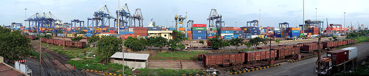
Port layout and infrastructure
Chennai port was the second smallest in the country measured by surface area, encompassing only 274 hectares. Chennai port area is divided into north, central and south zones and fishing harbours. The port has 26 alongside berthsBerth (moorings)
A berth is a location in a port or harbour used specifically for mooring vessels while not at sea.-Locations in a port:Berth is the term used in ports and harbors to define a specific location where a vessel may be berthed, usually for the purposes of loading and unloading.Most berths will be...
, including 21 deep-drafted berths and 2 oil jetties, in the 3 docks
Dock (maritime)
A dock is a human-made structure or group of structures involved in the handling of boats or ships, usually on or close to a shore.However, the exact meaning varies among different variants of the English language...
, viz., Dr. Ambedkar Dock, Satabt Jawahar Dock, and Bharathi Dock along with the container terminal, and draft ranging from 12 metre. Dr. Ambedkar Dock has 12 berths, Jawahar Dock has 6 berths, Bharathi Dock has 3 berths (for oil and iron ore), the container terminal has 3 berths and the moorings has 1 berth. The berths can handle containers as well as liquid and dry bulk and breakbulk cargoes. The approach channel to the port is 6700 m (21,981.6 ft) long, and the turning basin is 560 m (1,837.3 ft) in length. A total of 9 well-lit channels marks buoys for the approach channel.
| Region | Water spread | Land area | No. of berths |
|---|---|---|---|
| Inner harbour | 218 acres | 413 acres | 16 |
| Outer harbour | 200 acres | 100 acres | 7 |
| Total | 418 acres | 513 acres | 23 |
The Jawahar Dock has six berths with a total length of 1310 m (4,297.9 ft) and maximum permissible draft of 10.4 m (34.1 ft) and 11 m (36.1 ft). All berths are 218.3 m (716.2 ft), and half of them have maximum draft of 10.4 m (34.1 ft). The dock mainly handles coal, fertilizer, iron ore lumps, pellets, edible oil, and phosperic acid. The Dr. Ambedkar Dock has 13 berths with a total length of 1676 m (5,498.7 ft) and maximum permissible drafts from 8.5 metre. The longest berth is 246 m (807.1 ft) long with maximum draft of 9.5 m (31.2 ft). Berth No. 7 is 198 m (649.6 ft) long with maximum draft of 8.5 m (27.9 ft), whereas Berths 8, through 12 are each 170.6 m (559.7 ft) and have maximum draft of 11 m (36.1 ft). Berth 14 is 179 m (587.3 ft) long with maximum draft of 9.5 m (31.2 ft). Berths 18 and 19 are naval berths. The dock has car and cruise terminals and chiefly handles general cargo, cars, granite steel, and food grains. The Bharathi Dock contains three berths with total quay length of 917.2 m (3,009.2 ft), with berths ranging from 274.3 m (899.9 ft) in length with maximum permissible draft of 16.5 metre in length with maximum draft of 14.6 m (47.9 ft). The dock has three terminals, namely, container terminal, iron ore terminal, and oil terminal. It mainly handles containers, iron ore, and POL (petroleum, oil and lubricants).
| Dock/Terminal | No. | Name of berth | Type | Length (m) |
Permissible draft (m) |
Remarks |
|---|---|---|---|---|---|---|
| Jawahar Dock | 1 | JD-1 | Food grains/general | 218.33 | 11.50 | 12.0 m on HW subject to the vessel reducing the draft to permissible draft of the berth below low tide. Transit shed attached |
| 2 | JD-3 | Food grains/general | 218.33 | 11.50 | Transit shed attached | |
| 3 | JD-5 | Food grains/general | 218.33 | 11.50 | Transit shed attached | |
| 4 | JD-2 | Coal/other liquid bulk | 218.33 | 11.50 | ||
| 5 | JD-4 | Coal | 218.33 | 11.00 | ||
| 6 | JD-6 | Other ores/coal | 218.33 | 11.00 | ||
| Dr. Ambedkar Dock | 7 | NQ | Passenger/general | 198.00 | 8.50 | |
| 8 | WQ-1 | General/other liquid bulk | 170.60 | 11.00 | ||
| 9 | WQ-2 | General | 170.60 | 12.00 | ||
| 10 | CB | General | 170.60 | 12.00 | Transit shed attached | |
| 11 | WQ-3 | General | 170.60 | 12.00 | ||
| 12 | WQ-4 | Fertilizer/general | 170.60 | 11.00 | 11 m up to 795 m; 9.5 m up to 810 m |
|
| 13 | SQ-1 | Fertilizer/general | 246.00 | 9.50 | ||
| 14 | SQ-2 | Fertilizer/general | 179.00 | 9.50 | ||
| 15 | 2nd CT-1 | -- | 12.0 | |||
| 16 | 2nd CT-2 | -- | 12.0 | |||
| 17 | 2nd CT-3 | -- | 12.0 | |||
| 18 | Naval Berth North | 60.00 | 09.00 | |||
| 19 | Naval Berth South | 140.00 | 12.00 | |||
| Bharathi Dock (oil & iron ore) |
20 | BD-1 | Oil | 338.94 | 14.0 | |
| 21 | BD-3 | Oil | 304.00 | 16.50 | 17.0 m during HW; Between extreme dolphins |
|
| 22 | BD-2 | Iron ore | 274.32 | 16.50 | ||
| Container Terminal | 23 | CT-1 | Containers | 200.00 | 13.40 | Container freight station |
| 24 | CT-2 | Containers | 200.00 | 13.40 | Container freight station | |
| 25 | CT-3 | Containers | 200.00 | 13.40 | ||
| 26 | CT-4 | Containers | 285.00 | 13.40 | ||
| Approach Channel | Zone I | 750.00 | ||||
| Zone II to Zone VII | 5950.00 | |||||
| Turning Circle | 560.00 |
The oil terminals at the port's Bharathi Dock (BD1 and BD3) can accommodate tankers to 100,000 dead weight tonnage (DWT), and a third berth can handle tankers up to 280.4 m (919.9 ft) and 140,000 DWT. Berth BD1 can accommodate ships to 108.1 m (354.7 ft) long. The oil terminals have capacity to handle 12 million tons of cargo per year and to pump 3,000 tons of crude oil and 1,000 tons of petroleum products per hour. Each berth is equipped with five marine loading arms, and the berths have pipelines to convey crude oil, white oil, and furnace oil.
The port handles Suezmax
Suezmax
Suezmax is a naval architecture term for the largest ship measurements capable of transiting the Suez Canal, and is almost exclusively used in reference to tankers. Since the canal has no locks, the only serious limiting factors are draft , and height due to the Suez Canal Bridge...
tankers of up to a draft of 17 m at BD3 during day light, high tide as the per the present navigational practice and also during night hours subject to fulfilment of safety considertions on a ship-to-ship basis.
The iron ore terminal, which can handle 6 million tons per year and can load iron ore at a rate of 6,000 tons per hour, is also located at the Bharathi Dock. Berth BD2 can accommodate ore carriers up to 280.4 m (919.9 ft) in length. The terminal's separate receiving and shipping lines can function as an interconnected system. The terminal is served by rail lines and includes an ore stock yard with capacity for 544,000 metric tons.
The container terminal has four berths with a total quay length of 885 m (2,903.5 ft) and maximum permissible draft of 13.4 m (44 ft). With capacity to handle fifth-generation container vessels, three of the four berths are 200 m (656.2 ft) long, and one is 285 m (935 ft) long. The berths are served by seven quay cranes, including five super-post-Panamax and two post-Panamax cranes, and 24 gantry
Gantry
Gantry may refer to:*Gantry crane, a crane having a hoist fitted in a trolley for parallel movement*Gantry , the frame which encloses and services a rocket at its launch pad*Gantry , an overhead assembly on which highway signs are posted...
cranes. Operated by Chennai Container Terminal Private Limited, the container terminal has capacity for 950,000 TEUs. The container yard has 3,960 ground slots and 240 reefer plug points. The terminal contains 24 container freight stations with warehouse storage and offers 24-hr customs inspection and clearance facilities. The container terminal has direct services to Europe
Europe
Europe is, by convention, one of the world's seven continents. Comprising the westernmost peninsula of Eurasia, Europe is generally 'divided' from Asia to its east by the watershed divides of the Ural and Caucasus Mountains, the Ural River, the Caspian and Black Seas, and the waterways connecting...
, China
China
Chinese civilization may refer to:* China for more general discussion of the country.* Chinese culture* Greater China, the transnational community of ethnic Chinese.* History of China* Sinosphere, the area historically affected by Chinese culture...
, the United States
United States
The United States of America is a federal constitutional republic comprising fifty states and a federal district...
, Korea
Korea
Korea ) is an East Asian geographic region that is currently divided into two separate sovereign states — North Korea and South Korea. Located on the Korean Peninsula, Korea is bordered by the People's Republic of China to the northwest, Russia to the northeast, and is separated from Japan to the...
, Thailand
Thailand
Thailand , officially the Kingdom of Thailand , formerly known as Siam , is a country located at the centre of the Indochina peninsula and Southeast Asia. It is bordered to the north by Burma and Laos, to the east by Laos and Cambodia, to the south by the Gulf of Thailand and Malaysia, and to the...
, the Mediterranean region, and West Africa
West Africa
West Africa or Western Africa is the westernmost region of the African continent. Geopolitically, the UN definition of Western Africa includes the following 16 countries and an area of approximately 5 million square km:-Flags of West Africa:...
.
The warehousing and storage capacity available at the port is as follows:
| Type | Nos. | Area (sq.m) |
|---|---|---|
| Covered | ||
| Warehouses | 12 | 65,686 |
| Transit sheds | 8 | 36,000 |
| Covered area for FCI | 6 | 43,450 |
| Container freight stations | 2 | 12,600 |
| Open | ||
| Open space | 3,25,000 | |
| Container parking area | 1,30,000 |
The port handles a variety of cargo including iron ore, coal
Coal
Coal is a combustible black or brownish-black sedimentary rock usually occurring in rock strata in layers or veins called coal beds or coal seams. The harder forms, such as anthracite coal, can be regarded as metamorphic rock because of later exposure to elevated temperature and pressure...
, granite
Granite
Granite is a common and widely occurring type of intrusive, felsic, igneous rock. Granite usually has a medium- to coarse-grained texture. Occasionally some individual crystals are larger than the groundmass, in which case the texture is known as porphyritic. A granitic rock with a porphyritic...
, fertilizer
Fertilizer
Fertilizer is any organic or inorganic material of natural or synthetic origin that is added to a soil to supply one or more plant nutrients essential to the growth of plants. A recent assessment found that about 40 to 60% of crop yields are attributable to commercial fertilizer use...
s, petroleum products
Petroleum
Petroleum or crude oil is a naturally occurring, flammable liquid consisting of a complex mixture of hydrocarbons of various molecular weights and other liquid organic compounds, that are found in geologic formations beneath the Earth's surface. Petroleum is recovered mostly through oil drilling...
, containers, automobiles and several other types of general cargo items. Due to the increase in container traffic, a second container terminal was planned and tender works given to PSA Sical. It has asked for support for a mega container terminal. The terminal would be the first deep-water terminal of its kind in India and would be able to handle ultra-large container ships of 13,000-15,000 TEUs capacity and length exceeding 400 m (1,312.3 ft). The management of the container terminal was taken over by P&O Ports of Australia
Peninsular and Oriental Steam Navigation Company
The Peninsular and Oriental Steam Navigation Company, which is usually known as P&O, is a British shipping and logistics company which dated from the early 19th century. Following its sale in March 2006 to Dubai Ports World for £3.9 billion, it became a subsidiary of DP World; however, the P&O...
. This has a volume growth of 20 per cent per year and has 59 per cent of the market share of South India. It has services to Singapore
Singapore
Singapore , officially the Republic of Singapore, is a Southeast Asian city-state off the southern tip of the Malay Peninsula, north of the equator. An island country made up of 63 islands, it is separated from Malaysia by the Straits of Johor to its north and from Indonesia's Riau Islands by the...
, Malaysia, Thailand, Myanmar
Myanmar
Burma , officially the Republic of the Union of Myanmar , is a country in Southeast Asia. Burma is bordered by China on the northeast, Laos on the east, Thailand on the southeast, Bangladesh on the west, India on the northwest, the Bay of Bengal to the southwest, and the Andaman Sea on the south....
, Sri Lanka
Sri Lanka
Sri Lanka, officially the Democratic Socialist Republic of Sri Lanka is a country off the southern coast of the Indian subcontinent. Known until 1972 as Ceylon , Sri Lanka is an island surrounded by the Indian Ocean, the Gulf of Mannar and the Palk Strait, and lies in the vicinity of India and the...
, Korea, China, Mediterranean, Europe, Australia
Australia
Australia , officially the Commonwealth of Australia, is a country in the Southern Hemisphere comprising the mainland of the Australian continent, the island of Tasmania, and numerous smaller islands in the Indian and Pacific Oceans. It is the world's sixth-largest country by total area...
and the United States.
The port has a current depth of 17 m (55.8 ft) and is capable of handling fourth-generation vessels up to 150,000 DWT. It is going through an expansion and will have a depth of 18 metre, a continuous quay length of 2 km (1.2 mi) and back-up area of around 100 ha (247.1 acre). Two new breakwaters for a total length of 4 km (2.5 mi) will be constructed — one as extension of the existing outer arm and the other extending from the fishing harbor breakwater. The consequent silting will reclaim about 300 ha (741.3 acre) of land. The mega terminal will be built on a 100 hectares (247.1 acre) portion of this land. The terminal will have a continuous quay length of 2 km (1.2 mi) with 18 metre side along draft, capable of handling ultra-large container ships carrying over 15,000 TEUs. This will help it handle the latest generation vessels. Though the port is largely a container port, it has strategic importance as 3 service berths are allotted to the Indian Navy
Indian Navy
The Indian Navy is the naval branch of the armed forces of India. The President of India serves as the Commander-in-Chief of the Navy. The Chief of Naval Staff , usually a four-star officer in the rank of Admiral, commands the Navy...
.
The approach channel to the port has two sections—the entrance channel within the protection of outer arm and the outer channel beyond the protection of outer arm. The total length of the entrance channel is 7 km. The width of channel gradually increased from 244 m to 419 m at the bent portion, then maintains a constant width of 305 m. The depth of the inner and the outer channels are 18.6 m and 19.2 m, respectively, below chart datum, with a swell allowances of 3 m. The entrance is 350 m in Bharathi Dock and 125 m in Dr. Ambedkar Dock. The draught in the navigational channel is maintained by dredging approximately 1 million cubic metres annually.
Container terminals
The port has two container terminals, run separately by DP World Pvt. Ltd and SingaporeSingapore
Singapore , officially the Republic of Singapore, is a Southeast Asian city-state off the southern tip of the Malay Peninsula, north of the equator. An island country made up of 63 islands, it is separated from Malaysia by the Straits of Johor to its north and from Indonesia's Riau Islands by the...
's PSA International
PSA International
PSA International Pte Ltd, formerly Port of Singapore Authority is the second largest port operator in the world. The company's flagship operations are PSA Singapore Terminals, PSA HNN and PSA Marine...
Pte Ltd, with a combined capacity to handle 2.8 million standard containers a year. The two terminals loaded 1.11 million standard containers between April and December 2010, up from 886,000 containers a year earlier. Both the terminals have daily trains to Inland Container Depots (ICDs). There are plans to build a mega container terminal, the third one at the port, with private funds worth 36,860 million. The port is served by various container liner services, namely, APL
American President Lines
American President Lines Ltd. is the world's seventh-largest container transportation and shipping company, providing services to more than 140 countries through a network combining intermodal freight transport operations with IT and e-commerce...
, K Line
K Line
, also referred to as "K" Line, is a very large Japanese shipping company. It owns and/or controls large cargo ships, including dry cargo ships, container ships, container terminals, gas carriers, RoRo ships and tankers....
, Maersk Line, MOL
Mitsui O.S.K. Lines
is a Japanese transport company headquartered in Toranomon, Minato, Tokyo. The company's main area of operations is international shipping. Its alligator logo can be seen on containers in ports around the world....
, NYK
Nippon Yusen
Japan-based or NYK Line, is one of the largest shipping companies in the world. It is a core Mitsubishi company. The company has its headquarters in Chiyoda, Tokyo.-1870-1900:...
, PIL
Pacific International Lines
Pacific International Lines is a shipping company incorporated in 1967 and operates out of Singapore. It is one of the largest shipowners in Asia....
and several regional container lines.
Chennai Container Terminal
Chennai Container Terminal (CCT) is the first container terminal
Container terminal
A container terminal is a facility where cargo containers are transshipped between different transport vehicles, for onward transportation. The transshipment may be between container ships and land vehicles, for example trains or trucks, in which case the terminal is described as a maritime...
in Chennai port built in 1983. The container terminal was privatized in 2001 and is operated by DP World since 30 November 2001 with a capacity of 1.2 million TEUs. CCT is managed under a 30 year build-operate-transfer
Build-Operate-Transfer
Build-own-operate-transfer or build-operate-transfer is a form of project financing, wherein a private entity receives a concession from the private or public sector to finance, design, construct, and operate a facility stated in the concession contract...
agreement set up with the Chennai Port Trust of the Government of India. The terminal is capable of handling fifth generation vessels up to 6,400 TEU and has direct services to China, West Africa, Europe and the United States. The terminal crossed the "one million TEU" mark in 2007. In 2011, it handled 1.12 million TEUs. It enjoys a quay length of 885 m (2,903.5 ft) and has 4 berths with an alongside depth of 13.4 m (44 ft), height (ISLW to Top of Cope) of 34 m (111.5 ft), channel length of 6700 m (21,981.6 ft) and channel depth of 19.2 m (63 ft). The total terminal area covers 21.1 hectares, and yard stacking area covers 17 hectares (42 acre). The terminal has an on-site rail track. It has a berth productivity of 22 moves per hour and an average turnaround of 26 hours. The operator has invested around US$128 million to get new equipment at the terminal. At present, 7 quay cranes with Super Post Panamax
Panamax
Panamax and New Panamax are popular terms for the size limits for ships traveling through the Panama Canal. Formally, the limits and requirements are published by the Panama Canal Authority titled "Vessel Requirements"...
handling capacity and 24 rubber-tyred gantry cranes (RTGs) form part of the inventory. The operator has also taken over from Chennai Port 4 quay cranes, 10 RTGs, 3 reach stackers, 240 reefer plugs, and 2 top lifters and one empty container handler. CCT is ranked at the 79th position among the top 100 container terminals in the world. It is one of the fastest growing terminals in India with a CAGR
Compound annual growth rate
Compound annual growth rate is a business and investing specific term for the smoothed annualized gain of an investment over a given time period...
of 20 per cent. It presently has four mainline services with direct connectivity to Mediterranean, Europe, Thailand, Vietnam, China and Korea. The mainline services are complemented by seven weekly feeder services and one coastal service to Colombo
Colombo
Colombo is the largest city of Sri Lanka. It is located on the west coast of the island and adjacent to Sri Jayawardenapura Kotte, the capital of Sri Lanka. Colombo is often referred to as the capital of the country, since Sri Jayawardenapura Kotte is a satellite city of Colombo...
, Vizag, Penang
Penang
Penang is a state in Malaysia and the name of its constituent island, located on the northwest coast of Peninsular Malaysia by the Strait of Malacca. It is bordered by Kedah in the north and east, and Perak in the south. Penang is the second smallest Malaysian state in area after Perlis, and the...
, Port Klang
Port Klang
Port Klang is a town and the main gateway by sea into Malaysia. Colonially known as Port Swettenham, it is also the location of the largest and busiest port in the country. As such, its economic progress has been greatly influenced by the port activities in its area...
, Singapore
Singapore
Singapore , officially the Republic of Singapore, is a Southeast Asian city-state off the southern tip of the Malay Peninsula, north of the equator. An island country made up of 63 islands, it is separated from Malaysia by the Straits of Johor to its north and from Indonesia's Riau Islands by the...
, Yangon
Yangon
Yangon is a former capital of Burma and the capital of Yangon Region . Although the military government has officially relocated the capital to Naypyidaw since March 2006, Yangon, with a population of over four million, continues to be the country's largest city and the most important commercial...
and Port Blair
Port Blair
Port Blair is the largest town and a municipal council in Andaman district in the Andaman Islands and the capital of the Andaman and Nicobar Islands, a union territory of India...
, respectively. Presently, CCT is connected to 50+ ports worldwide. A container freight station, with a covered area of 6500 m² (7,773.9 sq yd), operates within the port offering such services as inspection, LCL de-stuffing and delivery of import cargo. CCT has plans to invest 1 billion to install two quay cranes.
Chennai International Terminal
Chennai International Terminal Pvt Ltd (CITPL) is the second container terminal
Container terminal
A container terminal is a facility where cargo containers are transshipped between different transport vehicles, for onward transportation. The transshipment may be between container ships and land vehicles, for example trains or trucks, in which case the terminal is described as a maritime...
that started operations from June 22, 2009 with berths SCB1, SCB2 and SCB3. The build-operate-transfer facility, built at a cost of about US$110 million, is a joint venture between PSA International and Chennai-based Sical Logistics Ltd. With 35 ha (86.5 acre) of yard space and three berths with a total quay length of 832 m (2,729.7 ft), the terminal offers an annual capacity of 1.5 million TEUs. It has 3 rail-mounted quay crane (RMQC), 10 rubber-tyred gantry crane (RTGC), 6 reach stacker and 120 reefer plugs. Once fully commissioned, CITPL would be able to accommodate 8,000-TEU vessels with drafts up to 15.5 m (50.9 ft).
Ro-ro car terminal
Dubbed the Detroit of Asia, Chennai is base to several international car makers, namely, Ford Motor Co.Ford Motor Company
Ford Motor Company is an American multinational automaker based in Dearborn, Michigan, a suburb of Detroit. The automaker was founded by Henry Ford and incorporated on June 16, 1903. In addition to the Ford and Lincoln brands, Ford also owns a small stake in Mazda in Japan and Aston Martin in the UK...
, Hyundai Motor Co.
Hyundai Motor Company
Hyundai Motor Company is a Korean multinational automaker based in Seoul, South Korea which, along with Kia, comprises the Hyundai Kia Automotive Group, the world's fourth largest automaker as of 2009. As of 2011, it is the world's fastest growing automaker for two years running...
, Nissan Motor Co.
Nissan Motors
, usually shortened to Nissan , is a multinational automaker headquartered in Japan. It was a core member of the Nissan Group, but has become more independent after its restructuring under Carlos Ghosn ....
, Renault SA
Renault
Renault S.A. is a French automaker producing cars, vans, and in the past, autorail vehicles, trucks, tractors, vans and also buses/coaches. Its alliance with Nissan makes it the world's third largest automaker...
, Daimler AG and BMW AG
BMW
Bayerische Motoren Werke AG is a German automobile, motorcycle and engine manufacturing company founded in 1916. It also owns and produces the Mini marque, and is the parent company of Rolls-Royce Motor Cars. BMW produces motorcycles under BMW Motorrad and Husqvarna brands...
. Car export (mainly Hyundai
Hyundai
Hyundai ) is a global conglomerate company, part of the Korean chaebol, that was founded in South Korea by one of the most famous businessmen in Korean history: Chung Ju-yung...
) increased by 80.25 per cent to touch 2,48,697 during 2008-09 as against 1,37,971 in the previous year. The port handled 65 car carriers compared with 40 in the previous year. In 2009, the port shipped nearly 274,000 cars, 10 per cent more than the previous year. The port is now the number one ro-ro car terminal in the country. After Hyundai, the port have started attracting global manufacturers like Mahindra
Mahindra Group
The Mahindra Group is an Indian multinational conglomerate company headquartered at Mahindra Towers in Mumbai, India, with operations in over 100 countries across the globe...
, Toyota, and Ford. Ford has decided to move exports to Chennai Port by 2010.
Hyundai Motor India is coming up with a first-of-its-kind dedicated automobile
Automobile
An automobile, autocar, motor car or car is a wheeled motor vehicle used for transporting passengers, which also carries its own engine or motor...
terminal
Shipping terminal
The term shipping terminal may apply to:* A Berth* A Dock * A Ferry slip* A Port* A Wharf...
at the Chennai port. The Chennai port facility is expected to be on the lines of its Ulsan
Ulsan
Ulsan , officially the Ulsan Metropolitan City, is South Korea's seventh largest metropolis with a population of over 1.1 million. It is located in the south-east of the country, neighboring Busan to the south and facing Gyeongju to the north and the Sea of Japan to the east.Ulsan is the...
Port, from where it exports half of Korea
Korea
Korea ) is an East Asian geographic region that is currently divided into two separate sovereign states — North Korea and South Korea. Located on the Korean Peninsula, Korea is bordered by the People's Republic of China to the northwest, Russia to the northeast, and is separated from Japan to the...
's 1,500,000 vehicles annually. The export terminal at the Chennai port would cater to its total export target of 300,000 cars, which would be 50 per cent of its total production by 2009-10. The company has plans to develop the land into a dedicated terminal to serve as an export base. It is believed that the terminal would basically cater to its export of compact cars from India. The new terminal, coming up at the southern end of the container terminal, would be spread over 10000 m² (11,959.9 sq yd) of land and includes a 300 m long, 30 m wide, and 12 m deep ro-ro berth. It would have two six-storey multi-level dedicated parking yard for 6,000 cars each, estimated at a cost of 400 million, where one ship load of cars can be stacked. The terminal, being developed at a cost of 800 million, would cater to other car exporters also and is expected to be completed by the end of 2012.
Cruise terminal
The port has a passenger cruise terminal in the West Quay. On an average, seven to eight cruise vessels dock in the port each year. The country's first cruise ship, AMET Majesty, is registered in Chennai and is set to start from Chennai on 8 June 2011.Operations
| Cargo-Handling Equipments | Total Units |
|---|---|
| Locos (diesel) Chittaranjan | 8 |
| BHEL loco | 10 |
| Diesel/electric loco | 2 |
| Mobile cranes | 12 |
| Fork lift trucks | 55 |
| Floating crane | 1 |
| Electrical forklift trucks | 24 |
| Pay loaders | 7 |
| Shore electric cranes | 25 |
| Transfer cranes | 10 |
| Tractor head | 34 |
| Container quay cranes (35.5T/40T capacity) | 4 |
| Toplift trucks (25T and 35T capacity) | 5 |
| Trailors | 32 |
| Crawler-mounted cranes | 3 |
| Empty container handler | 1 |
| Reach stackers | 3 |
| 10T/3T FLT | 7 |
The port handles around 8 million tonnes of coal for clients such as the Andhra Pradesh State Electricity Board, Karnataka Power Corporation, cement plants of Tamil Nadu and independent power producers in northern Tamil Nadu and southern Andhra Pradesh. The coal handling for the Tamil Nadu Electricity Board was transferred to the Ennore Port. In 2005, as part of pollution-control measure, the port has installed wind curtains made of ultraviolet resistant fabric along the harbour's beachfront for over 1.5 km to the east of the coal terminal to prevent wind carrying coal dust into the city at a cost of 3.7 million. In 2008, the port has also installed a semi-mechanised closed coal conveyor system comprising two streams with a capacity of 15 million metric tons/annum and a handling rated capacity of 1,500 metric tons/hour/stream and running for a length of 5 km at two berths, namely, Jawahar Dock IV and VI, at a cost of 430 million to transfer the coal to the individual coal plots at the southern end of the port, from where the cargo will be transported by rail to respective destinations, thus preventing pollution from coal dust and eliminating movement of coal-carrying trucks within the port. The conveyor runs at an elevation of 10-13 m and has provision for longitudinal movement along the road to the plots and transverse movement for stacking coal at individual plots. Coal discharged into the hoppers located at the two docks is conveyed to coal plots through conveyors or tripper cars and is equipped with belt weigher. The conveyor system is expected to remain functional for about 5 years, till Ennore Port is ready to handle coal for all the clients.
In 2007, a fully automated, round-the-clock helpline for providing information on the ships berthed and waiting, the scale of rates and facilities available at the port, the first of its kind in the country, was established. In the same year, the Indian government agreed to lift restrictions on concessionary Sri Lankan tea
Tea production in Sri Lanka
Tea production in Sri Lanka, formerly Ceylon, is of high importance to the Sri Lankan economy and the world market. The country is the world's fourth largest producer of tea and the industry is one of the country's main sources of foreign exchange and a significant source of income for laborers,...
and apparel exports at the port.
On 11 May 2011, the Madras High Court
Madras High Court
The Madras High Court is a senior court located at Chennai , in India. The court buildings, which are believed to be the second largest judicial complex in the world, are located near the beach, in one of the city's major business districts....
directed the Shipping Secretary that only clean cargo such as containers and cars be allotted to the port for handling from 1 October 2011. All dusty cargo such as coal and iron ore will be allotted to the Ennore Port.
The port is one of the six ports in India through which drugs are permitted to be imported, which is handled by the Central Drugs Standard Control Organisation (CDSCO), the other ports being Kolkata, Mumbai
Mumbai Harbour
Mumbai Harbour , or Front Bay, is a natural deep-water harbor in the southern portion of the Ulhas River estuary. The narrower, northern part of the estuary is called Thane Creek. The harbor opens to the Arabian Sea to the south...
, Nhava Sheva
Nhava Sheva
Nhava Sheva, officially Jawaharlal Nehru Port, is the 6th largest port and the largest container port in India. Located in Maharashtra, the port on the Arabian Sea is accessed via Thane Creek.- History :...
, Kochi and Kandla
Kandla
Kandla is a seaport in Kutch District of Gujarat state in western India. Located on the Gulf of Kutch, it is one of major ports on west coast. Kandla was constructed in the 1950s as the chief seaport serving western India, after the partition of India from Pakistan left the port of Karachi in...
ports.
As of 2011, cargo movement to the port is increasing by 21 per cent. Over 5,000 container trucks move through the port every day. However, the number of containers coming into the port has dropped by 30 per cent in the same year.
Meteorological functions
The cyclone detection radar station of the Southern Regional Meteorological CentreRegional Meteorological Centre, Chennai
The Regional Meteorological Centre at Chennai is one of the seven regional meteorological centres of the India Meteorological Department and is responsible for the weather-related activities of the southern Indian peninsula comprising the states of Andhra Pradesh, Karnataka, Kerala, Tamil Nadu...
is located at the "Centenary Building", the administrative building of the port. The Port Meteorological Office also functions from the same building. The India Meteorological Department
India Meteorological Department
The India Meteorological Department , also referred to as the Met Office, is an agency of the Ministry of Earth Sciences of the Government of India. It is the principal agency responsible for meteorological observations, weather forecasting and seismology...
(IMD) maintains Voluntary Observing Fleet (VOF) through the Port Meteorological Office comprising ships of Merchant Navy, Indian Navy and foreign agencies through which meteorological observations from the ocean area are collected on real-time basis for operational forecasting and climatological purpose.
Disease control
The Port Health Organisation, Chennai, functioning under the Director General of Health Services, Ministry of Health and Family Welfare, Government of IndiaGovernment of India
The Government of India, officially known as the Union Government, and also known as the Central Government, was established by the Constitution of India, and is the governing authority of the union of 28 states and seven union territories, collectively called the Republic of India...
, was established in 1946 with an objective of preventing entry of yellow fever
Yellow fever
Yellow fever is an acute viral hemorrhagic disease. The virus is a 40 to 50 nm enveloped RNA virus with positive sense of the Flaviviridae family....
and other quarantinable and communicable diseases from abroad. Mosquito control
Mosquito control
Mosquito control manages the population of mosquitoes to reduce their damage to human health, economies, and enjoyment. Mosquito control is a vital public-health practice throughout the world and especially in the tropics because mosquitoes spread many diseases, such as malaria.Mosquito-control...
in the port area is being undertaken by two agencies, namely, the Chennai Port Trust and the Port Health Organisation. Anti-mosquito measures are undertaken by the Port Trust while the issuance of yellow fever certificates, ship deratting and overall supervision of mosquito control is undertaken by the Port Health Organisation.
Extra-port connectivity
The foundation stone for the 6,000-million Chennai Port-Ennore road connectivity project was laid in January 2011. The Ennore Manali Road Improvement Project (EMRIP) is expected to be completed in 2 years. Of the total cost of 6,000 million, 2,500 million would be contributed each by the National Highways Authority of India and the Chennai Port Trust while 582 million would come from the Tamil Nadu government and rest by Ennore Port Ltd. EMRIP, which was conceived in 1998, has been under implementation for the past 10 years. The project envisages improvement of a 30.1 kilometres (18.7 mi) road network in north Chennai that connects all the container freight station handling containers for Chennai port. This includes 6 km (3.7 mi) of Ennore Expressway, 9 km (5.6 mi) of Thiruvotriyur Ponneri Pancheti Road, 5.4 km (3.4 mi) of Manali Oil Refinery Road, 8.1 km (5 mi) of the northern segment of Inner Ring Road, and 1.6 km (0.994196378639691 mi) of Chennai Port Trust Fishing Harbour Road, in addition to shore protection measures comprising 13 groins along the Ennore coast. The original cost of the project was 1,500 million but was revised due to addition of service road to the four lanes of Thiruvottiyur-Pooneri-Panchetti road, provision of underpass on Ennore Expressway Road and drainage on Manali Oil Refinery Road besides escalation of cost during the intervening period. The project completion is expected by June 2013.An 18.3 kilometres (11.4 mi) long, 20 metres (65.6 ft) wide elevated road project connecting the port with Maduravoyal is under construction at a cost of 16,550 million. Upon completion, this will be the country's longest four-way elevated expressway. The project was sanctioned in June 2007 when the Tamil Nadu Government gave its 'in principle' approval to the National Highway Authority of India (NHAI) for the elevated expressway. The project cost then was put at 14,680 million. In January 2009, the Prime Minister, Dr. Manmohan Singh, laid the foundation stone for the project but the project was put on hold for want of environment clearance. The project has got the environment clearance in February 2011, and during the same month, the port handed over a cheque for 500 million to the NHAI as part of its contribution to the project. The expressway starts from Gate No. 10 of the Chennai Port near the War Memorial and ends before Maduravoyal Interchange. It would run along the banks of the Cooum up to Koyambedu and would end along the Cooum near the Koyambedu grade separator. From there for a distance of three km up to Maduravoyal the elevated expressway would come up on Poonamallee High Road. There would be a total of four entry and exit ramps as part of the project. While the entry ramps would come up on Sivananda Salai and College Road, the exit points would be provided on Spurtank Road and Kamaraj Salai. The work at the Maduravoyal end began in December 2010. The project is being implemented on a build, own and transfer mode. Of the total project cost of 16,550 million, 3,100 million has been set aside for land acquisition and rehabilitation and resettlement of nearly 7,400 people living along the project area. About 1,300 people have been rehabilitated at Okkiam Thoraipakkam. Of 30 hectares to be acquired for the project, only 2 hectares belong to private owners. The project is expected to be completed by end of 2013.
Intra-port connectivity
The total port roads run to a length of 27.5 km with a minimum width of 6 m and a maximum width of 26 m.The port is served by the Chennai Beach
Chennai Beach
Chennai Beach , formerly known as Madras Beach, is a railway terminus of the Southern Railway Network in Chennai , India. This station handles mainly suburban trains in Chennai suburban railway and a few passenger trains...
railway terminus in the Chennai Suburban Railway Network
Chennai suburban railway
Chennai suburban railway is a commuter rail system in the Indian city of Chennai operated by the Southern Railway. Chennai has a complex railway network. The system uses electrical multiple units operating on alternating current drawn from over-head cables through the catenary system...
of the Southern Railway
Southern Railway Zone (India)
The Southern Railway is the earliest of the 16 zones of the Indian Railways created in independent India. It was created on April 14, 1951 by merging three state railways namely Madras and Southern Mahratta Railway, the South Indian Railway, and the Mysore State Railway. The South Indian Railway...
, chiefly handling suburban trains on the Chennai Beach
Chennai Beach
Chennai Beach , formerly known as Madras Beach, is a railway terminus of the Southern Railway Network in Chennai , India. This station handles mainly suburban trains in Chennai suburban railway and a few passenger trains...
-Tambaram
Tambaram
Tambaram is a suburb of Chennai situated 27 km south of the city in Tamil Nadu, India. It is an urban node. Tambaram is a hub to all major destinations in south Tamil Nadu as it lies on the busy Chennai–Trichy national highway. The highway and the railway line from Chennai Egmore to...
section of the Chennai Suburban Railway Network. The port is one among the major ports having terminal shunting yard and running its own railway operations inside the harbour. The port has broad gauge
Broad gauge
Broad-gauge railways use a track gauge greater than the standard gauge of .- List :For list see: List of broad gauges, by gauge and country- History :...
railway lines running up to 68.8 km (42.8 mi) and handled 25 per cent of the total volume of the cargo, 4,360 rakes (239,412 wagons) during 2009-10.
As part of the port development, internal railway lines are being augmented for the evacuation of containers from the port. Third and fourth railway lines are being developed by the Southern Railway to improve connectivity to the port and the rail share of container movement to 30 per cent from the current 7 per cent. The rest will be moved by road.
Per the 2004 statistics, 11 per cent of the containers arrived by train and the rest by road.
Every month, nearly 150,000 container-laden vehicles (both import and export) transit through the port's only available gate (Zero Gate) at Royapuram
Royapuram
Royapuram , a locality of Chennai, South India, is the place where the first railway station of south India was constructed, and from where the laying down of the second railway line of the South Asia commenced in the 1850s. This railway line extended from Royapuram to Arcot, then capital of the...
, north of the port.
Pipelines
The port is connected to the Chennai Petroleum Corporation's (CPCL) refinery in Manali via a 30-inch-diameter pipeline. CPCL is planning to replace this with 42-inch-diameter pipeline at a cost of 1,260 million along the proposed Quadrilateral Road Network from Chennai Port to Ennore-Manali Highway. However, citing threats to habitation, the government has refused clearance to the project.Natural disasters
The Indian Ocean Tsunami of 26 December 2004, one of the deadliest in the recorded history, had a devastating effect all over the region and, of course, damaged the port's infrastructure, including cranes, wharfs, moorings and some part of the ship channel and hindered the operations of the port for a brief period. Some of the ships hit the wharves close to where they were berthed. Other damages at the port include collision of three ships while being towed to deep sea resulting in the loss of about 1,500 tonnes of sugar and damages to some of the cars that awaited export. The port suspended operations for two days. The total damage to property, infrastructure and equipment at the port due to the tsunami stood at 129.6 million. Rebuilding the entry channels and affected areas is expected to incur another 100 million. The port suffered a loss of 30 million due to operational halt on 26th and 27th of December 2004, during which around 2,50,000 tonnes of container could not be serviced, with trade of 15 vessels on sail and 10 vessels at berth affected. This was in addition to the loss due to waiving of marine charges owing to the disaster.As a consequence of the tsunami
Tsunami
A tsunami is a series of water waves caused by the displacement of a large volume of a body of water, typically an ocean or a large lake...
, the port trust plans to create an artificial beach from left of the Cooum River
Cooum River
The Cooum River , is an urban river which ends in the city of Chennai draining into the Bay of Bengal. Along with the Adyar River running parallel to the south, the river trifurcates the city and separates Northern Chennai from Central Chennai.The name of Cooum appears to be derived from Tamil...
(next to the Napier bridge) right up to fishing harbour in North Chennai covering about 10 km to protect the port from seaside from similar natural calamities. The beach is planned within the port's territory before the east breakwater on the seaside and would not be accessible to the public. In addition, the port is also planning to reclaim the land adjacent to the Cooum during the Tenth Plan.
On the flip side, the disaster has made the port the deepest on the east coast. A bathymetry survey conducted by the National Institute of Ocean Technology (NIOT) to measure the depth of the sea has revealed the entry channel to the port has deepened enabling the berthing of vessels of deeper drafts. The high current generated by the tsunami waves dredged about 0.4 to 0.5 million cubic metres of sediments, which has deepened the 17.4 m-deep harbour by 1 to 2 m more, especially along the Dr. Ambedkar Dock and the Barathi Dock. Similarly, the depth of the entry channel, which was 18.6 m, has deepened by a metre.
Lights and lighthouses
There are both historic and modern lighthousesLighthouse
A lighthouse is a tower, building, or other type of structure designed to emit light from a system of lamps and lenses or, in older times, from a fire, and used as an aid to navigation for maritime pilots at sea or on inland waterways....
in and around the port, some of which have been decommissioned. The port is the location of one of Chennai's earliest lighthouses—the entrance channel tower. The 24 m (79 ft) tall tower with a focal plane of 26 m (85 ft), flashing white, red and green lights, is located north of the port. It is visible only from around the entrance channel. This tower is still active. However, the first lighthouse of the city is located just outside the port, in Fort St. George campus. It was active from 1796 till 1844. The second and third lighthouses are located in the Madras High Court campus near the port.
The present lighthouse is located about 6 km south of the port on the Marina Beach
Marina Beach
Marina Beach is a beach in the city of Chennai , India, along the Bay of Bengal, part of the Indian Ocean. The beach runs from near Fort St. George in the north to Besant Nagar in the south, a distance of , making it the longest urban beach in the country and the world's second longest...
. It is a 46 m (151 ft) tall, 11-storied triangular cylindrical concrete tower with lantern and double gallery, attached to a 3-story circular harbour-control building, emitting light from a height of 57 m (187 ft) from the mean sea level. This lighthouse, which is active since 1977, is powered by a 440V, 50 Hz main supply.
The future
A third box terminal has been approved by the Cabinet Committee on Infrastructure. This will require investment of US$800 million and will be offered as a build-operate-transfer project, as part of a 30-year concession. Construction will take seven years to complete and the deep-water container terminal will have a capacity of 4 million TEU. The mega container terminal project, expected to be the single largest terminal ever built in India, is to be developed north of existing Bharathi Dock with two new breakwaters (total length of 4.23 km (2.6 mi)), continuous quay length of 2 km (1.2 mi) with 22 m (72.2 ft) alongside depth (ultimate) and a basin area of 300 hectares and back up area of 100 hectares. The gigantic proportions will feature 2 km quay length in a straight line at the new outer harbour, with a 2.75 km extension of the existing outer arm breakwater and a new northern breakwater of 1.73 km emanating from the eastern breakwater of the fishing harbour. The project also involves converting waterfront into 225 acres of land. The other side of breakwater would be used by the port as a berth to handle oil vessels. The project will be the first deep-water terminal of its kind in India and can handle ultra-large container ships of capacity over 15,000 TEUs and length of 400 m (1,312.3 ft). Overall project completion is expected by 2018. In September 2011, Mundra Port and Special Economic Zone Ltd (MPSEZ) emerged as the sole and lowest bidder for constructing the mega terminal. Based on earlier projections, Chennai is expected to handle 5 million TEUs by 2017.Chennai Port Trust has plans to build a marina
Marina
A marina is a dock or basin with moorings and supplies for yachts and small boats.A marina differs from a port in that a marina does not handle large passenger ships or cargo from freighters....
along a 200 metres (656.2 ft) stretch in the west quay to berth a dozen yachts. The marina will provide lockers, separate berths and other facilities to these sailors, who come in small boats. The sailors can then proceed inland for sightseeing. However, the plan still remains on paper. Although the plan to build a large-scale marina is at the proposal stage, the port cannot have a marina till the coal yard is vacated. After coal
Coal
Coal is a combustible black or brownish-black sedimentary rock usually occurring in rock strata in layers or veins called coal beds or coal seams. The harder forms, such as anthracite coal, can be regarded as metamorphic rock because of later exposure to elevated temperature and pressure...
handling is moved out, the port will reclaim land by constructing groynes—rigid hydraulic structures built from an ocean shore that interrupt water flow and limit the movement of sediment.
The Rajiv Gandhi dry port (container freight station) and multi-modal logistics hub near Sriperumbudur
Sriperumbudur
Sriperumbudur is an industrial city in Kanchipuram district in the Indian state of Tamil Nadu. It is located in proximity to Chennai. It is famous for being the birth place of Sri Ramanuja, one of the most prominent Hindu Vaishnava saints as well as the town where former Indian Prime Minister...
special economic zone (SEZ) is under development at an estimated cost of 3,800 million, including land cost of 1,001.6 million. Proposed components include ICD/off-dock CFS, container yard, rail and road connectivity to national rail and road network, trade centre, warehouses for containerized cargos like leather garments, textiles, automotive components and electronic hardware. A total of 125 acres of land at Mappedu in the Sriperumbudur SEZ alloted by SIPCOT
SIPCOT
The State Industries Promotion Corporation of Tamil Nadu , Limited is an institution owned by the government of Tamil Nadu and is intended as a catalyst for the development of small, medium and large scale industries in Tamil Nadu. It was established in 1972.SIPCOT has established industrial...
of the Government of Tamil Nadu is being acquired for the project on a 99-year lease basis. The first-of-its-kind project is expected to be completed by 2014. The distance between Chennai Port and the dry port is about 50 km (31.1 mi). About 19 km (11.8 mi) would be covered by the elevated corridor, 16 km (9.9 mi) by National Highway 4 and balance by a single-line state highway that would be converted into two-lane soon. The dry port would consist of 75 acre (30.4 ha) of custom-bound area and 50 acre (20.2 ha) of non-custom bound area and would accommodate containers, hazardous and non-hazardous materials. A barge jetty-cum-liquid cargo terminal at an outlay of 250 million is also being proposed on PPP mode. This is one of the three container freight stations planned by Chennai Port Trust.
A barge handling facility at the Bharathi Dock is being developed at a cost of 250 million. The project is expected to be completed by 2013. The 200 m long barge jetty is being developed with a depth of 10 m and back area of 7,500 m. The jetty is proposed to be constructed between the iron ore berth and oil terminal so as to cater to barges and bunkers and similar vessels handling liquid cargo.
The port is planning to construct a parking facility on an 11-acre stretch in Thiruvottiyur for container trucks. The port is also investing 500 million to have more berths exclusively for bunkering.
The port has decided to have a 7.5 MW wind energy farm in Tirunelveli district
Tirunelveli District
Tirunelveli District is a district of Tamil Nadu state in southern India. The city of Tirunelveli is the district headquarters. A unique feature of this district is that it encompasses all five geographical traditions of Tamil Literature; kurinji , mullai , marudham , neithal and palai...
at an outlay of 493.1 million.
To reduce congestion at the harbour, which has two bays (two each for entry and two for exit of containers), the port plans to modernise zero gate and open one more bay and widen the roads that lead to zero gate and to lay six to eight lanes from the zero gate to avoid stranding of vehicles.
Sister ports
The port has sister port agreements with the following ports to cooperate in maritime transportation and port development. This will also cover technical expertise, cruise knowledge, container terminal and tourism between the sister ports.| Country | ort | tate / Region | ince |
|---|---|---|---|
 Belgium Belgium Belgium BelgiumBelgium Belgium , officially the Kingdom of Belgium, is a federal state in Western Europe. It is a founding member of the European Union and hosts the EU's headquarters, and those of several other major international organisations such as NATO.Belgium is also a member of, or affiliated to, many... |
Port of Zeebrugge Port of Zeebrugge The port of Bruges-Zeebrugge is a large container, bulk cargo, new vehicles and passenger ferry terminal port in the municipality of Bruges, Flanders, Belgium, handling over 50 million tonnes of cargo annually.-General:... |
 West Flanders West Flanders |
November 2008 |
 Canada Canada Canada CanadaCanada Canada is a North American country consisting of ten provinces and three territories. Located in the northern part of the continent, it extends from the Atlantic Ocean in the east to the Pacific Ocean in the west, and northward into the Arctic Ocean... |
 Port of Halifax Port of Halifax |
 Nova Scotia Nova Scotia is one of Canada's three Maritime provinces and is the most populous province in Atlantic Canada. The name of the province is Latin for "New Scotland," but "Nova Scotia" is the recognized, English-language name of the province. The provincial capital is Halifax. Nova Scotia is the... |
January 2009 |
See also
- Ennore PortEnnore PortEnnore Port, located on the Coromandel Coast about 24 km north of Chennai Port, Chennai, it is the 12th major port of India, and the first port in India which is a public company. The Ennore Port is the only corporatised major port and is registered as a company...
- Kattupalli ShipyardKattupalli ShipyardThe Kattupalli Shipyard cum Captive Port Complex is a large shipyard project at Kattupalli village near Ennore of Chennai being built by L&T Shipbuilding Ltd. It is being set up jointly by TIDCO and Larsen & Toubro in two phases...
- Ports in IndiaPorts in IndiaIndia has a long coastline, spanning 7600 kilometres, forming one of the biggest peninsulas in the world. It is serviced by 13 major ports and 187 notified minor and intermediate ports. The latest addition to major ports is Port Blair on June 2010, the 13th port in the country.Major ports handled...