
Adamawa Province
Encyclopedia
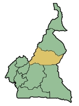
The Adamawa Region is a constituent region of the Republic of Cameroon
. It borders the Centre and East regions to the south, the Northwest and West regions to the southwest, Nigeria
to the west, the Central African Republic
(CAR) to the east, and the North Region to the north.
This mountainous area forms the barrier between Cameroon's forested south and savanna north. At almost 64,000 km² in land area, the Adamawa is the third largest of Cameroon's ten regions. The land is rugged and sparsely populated, however, as most is devoted to the rearing of cattle
. The Muslim
Fulbe
(Fulani) form the major ethnic group, though Tikar
, Gbaya
, and other peoples are present in lesser numbers.
signed decrees abolishing "Provinces" and replacing them with "Regions". Hence, all of the country's ten provinces are now known as Regions.
, which gives way to crystalline
and metamorphic rock
such as mica
, schist
s, and gneiss
. These are often covered in volcanic basalt
, a combination that dominates until the Faro River. East of this, granites once again prevail, though sedimentary rock
forms the valley of the Mbéré River, and a zone of metamorphic rock surrounds this. The Lom River
also rises in a region of metamorphic rock. Volcanic rock
occurs in the northwest just east of the Gotel Mountains and northeast of Ngaoundéré
, the provincial capital, along the border with the North Province.
Soils are mostly made up of brown or brownish-red laterite
s, the result of the annual shift between dry and wet conditions and soil wash on the mountains. Iron
and aluminium
content is high, which causes hardpan
s, duracrust, or cuirass
es to form near the surface due to oxidation. The soil of the Lom valley is a lightly evolved composition of raw materials, as is that directly northwest of the Mbakaou Reservoir and directly west of the Faro River. The extreme northwest of the province has ferruginous soil instead, and many of the province's mountains, including the Gotels and Mambilas, contain mixtures of several soil types.
, to Lake Chad
, and to the Atlantic Ocean
.
The Mayo Deo River rises in the Gotel Mountains and then flows into the North Province. The Faro River begins a short distance east of the Mayo Deo but follows a wide, arcing course east and north between the Vina division and the Faro and Deo division before entering the North Province (the two rivers eventually join).
Two major rivers represent the Chad basin. The Mbéré rises north of the town of Meiganga
and then flows northeast toward the border with the North Province and the Central Africa Republic. The headwaters of the Vina River flow just north of Ngaoundéré before the river enters the North Province. These two rivers eventually merge to form the Logone River.
The Mbam
, Kim, and Djérem are the major rivers of the Atlantic basin. The Mbam and Kim both rise in the southwest before flowing into the Centre Province. The Djérem forms in eastern and western branches, which converge at the Mbakaou Reservoir. The river then flows south into the East Province. Due to the reservoir (which holds two million cubic metres of water), the Djérem forms an important source of hydroelectric power for Cameroon. Finally, the Lom rises about 60 km east of Meiganga before flowing south into the East Province. The Djérem eventually becomes the Sanaga River
, and these other rivers ultimately empty into it.
A long history of volcanism
has also created a number of crater lake
s in the province, the results of collapsed volcano
es filling with water. Among the most well known are Lakes Tison (Tyson, Tisson) and Mbalang near Ngaoundéré.

. The land rises gently but unevenly until about 6 degrees latitude
. Here begins the Adamawa Plateau
, a band of terrain that ranges from 1,000 to 2,000 m in altitude (averaging about 1,100 m) and stretches from Nigeria to the CAR. Altitude dips to as low of 500 m in the Djérem and Mbéré valleys and at the border north of Ngaoundéré. The plateau continues to about 8 degrees north
before descending to the Benué Depression in abrupt cliffs and active volcanoes (though this transitional zone is mostly in the North Province).
Faults also cut across the area, the major one being the Cameroon Fault, dating from the Cretaceous Period. The Mbang Mountains follow this fault in a rough cut toward the east. Other mountains dot the province, as well. The Mambilas stretch into the extreme southwest from Nigeria and the Northwest and West Provinces. The Gotels are north of these along the border with Nigeria. All of these mountains form part of the Cameroon Ridge. Tchabal Mbabo, in the Gotels, is the highest peak at 2,460 m.
The climate of the Adamawa Plateau is classified as tropical
of the Sudan type. It has only two seasons; November begins the dry period, and April the wet. Rainfall here averages 900 to 1,500 mm per year and decreases further north. May and June are the wettest, with occasional tornado
es; August is another rainfall peak. In addition, temperatures dip from November to January, as conditions similar to those that cause winter in temperate climes take at least a tentative hold. Temperatures rise due to the Harmattan
beginning in January, reaching a high in April. Torrential rains in May and June bring temperatures down once again.
A third climate type characterises the Adamawa's southwest corner (most of the Mayo-Banyo division). This region experiences an equatorial climate of the Cameroon type. Rainfall is within 1,500 to 2,000 mm with a long dry period followed by a long wet period.
What few trees dot the landscape are evergreen
and deciduous
until about 1800 m altitude, when fern
s and bamboo
s become prevalent. Grasses are the dominant form of plant life throughout except in the few forested areas and in some regions of scrubby bush. In addition, the southwestern half of the Mayo-Banyo division is a more heavily forested woodland savanna.
The Adamawa has two national reserves. The first of these is the Parc National du Mbam et Djérem, which protects 4165 km² in both the Adamawa and East Provinces. The park is notable for containing both large tracts of savanna and forest. In addition, a small portion of the Parc National de Boumba Ndjida extends into the territory from the North Province.
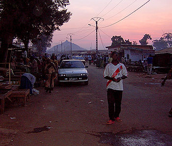
Ngaoundéré is one of Cameroon's fastest growing cities due to its location at the terminus of Cameroon's north-south railroad. The modern city is thus a sprawling mass of winding streets surrounding the traditional town. It is also a microcosm of the province's ethnic diversity, as representatives of most of the Adamawa's peoples can be found there.
The Mayo-Banyo division in the southwest has a slightly higher population density than the rest of the province, largely due to the highly concentrated Mambila
and Konja of the Mambila Mountains and the Vute and Pere
of the Gotel Mountains. The Pere are also known as the Kutin or Koutine, though this is in fact a highly derogatory term meaning "dogs" that was given to them by the Fulbe. The northern border also has a slightly higher population density than the Fulbe interior.
. These Bantoid peoples primarily occupy the province's western third, in the Faro and Deo and the Mayo-Banyo divisions. The Ndoro are the northernmost, living on the Nigerian border on the upper Mayo Deo. To their south lie the Nyem-Nyem, called Suga by the Mbum, in the northern third of Mayo-Banyo division and along the west bank of the Meng River
. The Vute live south of them on the Nigerian border and in a second population centre on the southwestern bank of the Mbarkaou Reservoir. The Mambila inhabit the southwestern border, and the Konja lie inland from them along the Banyo-Bankim road. The Tikar are at the province's southwestern corner, with territories extending into the neighbouring provinces.
 Those peoples who speak Adamawa languages
constitute the next major grouping. The Pere are farthest west of these, living in three main concentrations. The first is at the province's northwest, north of Mayo-Baleo town. They have another centre at the village of Paro south of Tignère
, and their third grouping on the Meng River
. The Kali at the province's northeast, along the North Province border centred at Bélél
. The Mbum
(Mboum) are the last group, occupying the town of Ngaoundal
and its environs. East of Ngaoundéré are the Dii
, who have larger territories in the North Province.
As speakers of an Ubangi language, the Gbaya make up another important grouping. Their territory spans the whole of the Mbéré division as well as a small area at the southwest of the Vina division. They continue south into the East Province.
The Fulbe make up an estimated 60% of the Adamawa's population. They are further subdivided into two subgroups: the sedentary, or town, Fulbe and the pastoral Fulbe, or Bororo. The sedentary Fulbe are more numerous and inhabit most of the province's major towns, including Banyo, Tibati
, Tignère
, and Ngaoundéré, the capital. Over years of intermixing with native populations, they have come to physically resemble their Sudan
ese neighbours. The pastoral Fulbe create only temporary settlements, preferring instead to range across the province and beyond with large herds of cattle. These Fulbe are lighter skinned than their town brethren, tall and thin, with Arab-looking features.
The Fulbe speak a Cameroonian dialect of the Senegambian language Fulfulde
. Due to their historical hegemony of the territory, it also serves as a lingua franca. Other major languages include Bitare, Dii
, Gbaya, Mambila
, and Tikar
. Most educated inhabitants also speak French.
has made some inroads, though Christians are in a distinct minority. Many of the tribes retain animist, or "pagan
", beliefs, particularly in the mountains near the Nigerian border.
, a Fulbe monopoly. The region's low population, high humidity, and vast fields of grass make it ideal for grazing. Herdsmen rotate pastures, and they often construct watering holes or wells for themselves and their animals.
The close relationship between the Bororo and their herds lends a great cultural importance to a Fulbe's number of cattle, and the more heads of cattle a man has, the wealthier he is. This often leads herders to never kill their animals, however, and to keep sick animals alive for fear of losing a portion of one's net worth. Nevertheless, many Fulbe herders transport their cattle to the big markets of Yaoundé
and Douala
for sale (some make it as far as Gabon
and Congo
). The major transhumance
paths are in the western third of the province and at the border with Chad.
Most of these animals are of the humpbacked zebu
breed. Near Ngaoundéré and Banyo, these are called Peul zebu, large and meaty animals with dark-brown hides and white spots. The nomadic Fulbe, on the other hand, herd Bororo zebu. These are leaner, lighter-coloured beasts that are better able to travel long distances.
The government-run Institut de Récherche Zootechniques (IZR) and SODEPA have established a handful of modern cattle ranches, as well. The major ones are near the villages of Laro
, Wakwo and Ndokayo. Here, ranchers have bred
new breeds of cattle by mixing native Fulbe animals with the American Brahmin
. Government initiatives have also been instrumental in the eradication of the tsetse fly
in the region.
Many ranchers and Bororo also raise horse
s and donkey
s. In addition, the Adamawa has more goat
s and sheep than any other province, as these can live even in the larger towns. Pig
s, however, are much less common due to the prevalence of Islam in the region.
level. Millet
is the mainstay, though maize
, and manioc
are also important. Other crops, grown in smaller quantities, include cocoyam
s, yams
, and groundnut
s.
The Gbaya, Mbum, and Dourou
are the region's most prolific farmers, though even the herdsmen farm in the rainy season. Farms are typically small plots that are cleared or burned out of the brush and then planted during the dry season. Crops grow during the rainy season, when they are harvested. Because the dry season is so long, crops must be preserved, so most are transformed into grain
, which is pounded by hand with mortar and pestle.
Cash crop
s play a small role in the region's economy. SODEBLE grows wheat
on 100 km² at Wassandé, near Ngaoundéré. The southwestern Mayo-Banyo division also has some coffee
plots. Other interests have established groundnut, millet, and wheat plantation
s in recent years.
, most located in the capital. Much of this is tied to the region's cattle-based economy. For example, leatherworking is an important industry in Ngaoundéré, as evidenced by the Société des Tanneries et Peausseries du Cameroun (STPC) factory. Rubber
, perfume
, and dairy product
s are also processed in the capital. Handicrafts, including woodworking
and mat weaving
, form another sector. Tin
is mined
near Mayo Darlé and the Nigerian border and southwest of Banyo, and bauxite
is mined near Ngaoundal
and Minim-Martap. Mineral water
is obtained at Doungué.
Road travel from the south is also possible, but this is limited to poor roads from the Centre Province or else a long detour through the East Province, where the roads are not much better. Roads within the Adamawa itself are mostly unpaved and are often in poor condition (particularly south of Ngaoundéré) due to little maintenance. The road north from Ngaoundéré into the North Province is paved, however, meaning that those traveling via train can continue to the North and Far North without too much discomfort. National Road 6 enters the province from Foumban
in the West Province and continues on to Banyo, Tibati, and Meïganga. National Road 15 comes from Sangbé in the Centre Province to Tibati and on to Ngaoundéré.
A regional airport services Ngaoundéré with flights to Yaoundé, Douala, Garoua
, and Maroua
. Tignère, Banyo, Ngaoundal, Tibati, and the Mbakaou Reservoir all have airstrips.
s allow tourists to visit their palaces, for example, such as the ruler of Ngo, who receives nobles every Friday and Sunday. The province also has numerous scenic destinations ranging form crater lakes to caves and waterfalls.
With its low population, the Adamawa holds little import to Cameroonian politicians. However, the Fulbe tribe is spread throughout the country, especially in the three northern provinces, and together they form a significant bloc that Cameroonian politicians cannot easily ignore. This is one way that Cameroon's greater north is able to oppose policies more favourable to the south.
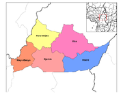 Adamawa is composed of five departments ():
A presidentially appointed prefect
(), or senior divisional officer, governs each of these. The president also appoints the governor
, whose offices are in Ngaoundéré.
Most other tribes in the region are nominally under the rule of a chief
. However, these men are mostly just figureheads today. Among the Tikar, however, these individuals still hold a substantial amount of power. A group of advisers, or "Council of Notables", serves each Tikar chief. Below them are various ward heads () who govern a specific portion of a village or town. The quarter chiefs () hold sway over a particular neighbourhood.
Another obstacle is lack of schools and teachers. Most schools are located in larger towns or in the capital, meaning that students often must travel long distances or live away from home, particularly at the secondary
level. In addition, Cameroonian teachers who are assigned to the province often refuse to go on account of its remoteness.
. This is especially pronounced in the increasingly urbanised Ngaoundéré. Another concern is HIV
and AIDS
. Official government figures give the province an HIV-infection rate of 17%, the highest in the country. These numbers come from samples in Ngaoundéré only, however, and infection rates in more rural areas are probably lower.
, Doayo, Fali
, Mundang (Moundang), and Tupuri
(Toupouri).
The Kanem-Bornu Empire
of Lake Chad had relations with these tribes. They called the area Fumbina or Mabina (a name which denoted the present province as well as territories in present-day Nigeria and the Central African Republic). The Kanem-Bornu also introduced Islam to the region between 1349 and 1385 by way of the Islamic centre at Kano
in present-day Nigeria. However, no more than a few rulers, nobles or merchants ever converted.
Many more tribes entered the territory from the region of Chad between the 14th and 17 centuries. These included the Semi-Bantu tribes, such as the Bamileke
, Bamun
, Kom, Nso
, Tikar, Widikum, and Wimbam. The Bantu came as well, examples being the Beti-Pahuin
and Maka
and Njem
. Other groups who came were the Gbaya, from the present CAR, and the Vute, from the Lake Chad region. The Vute were region's first iron workers, and they founded the towns of Mbamnyang (present Banyo) and Tibaré (present Tibati). The Semi-Bantu peoples gradually moved south before settling near the headwaters of the Mbam River sometime between the 17th and 19th centuries. The Bantu settled east of them, south of the Adamawa Plateau. One or all of these populations founded Banyo, Tibati, and Ngaoundéré.
Meanwhile, the Bantu and Semi-Bantu invasions drove the longer-established Sudanese peoples north. The Mbum, Ndoro, Kutin, and Laka-Mbere moved to the present-day province's northern reaches, while the other Sudanese migrated even farther. This period marked the highest population for the Adamawa territory until modern times. However, one event had drastic consequences for the region: the arrival of the Fulbe.
In 1804, Fulbe in the territory and beyond were growing disenchanted with submission to pagan tribes. They were also hungry for larger territories that they could use for cattle grazing. The Fulbe leader Usman dan Fodio
responded to this sentiment and called a jihad
. Usman named his lieutenant Modima Adam Al-Hasan, or Modibo Adama
, lamido of Fumbina, and Adama quickly raised an army in the territory.
Adama's forces proved all but unstoppable. He conquered major Vute centres at Mbamnyang and Tibaré in 1835, which he renamed Banyo and Tibati. At Adama's death in 1847, Fulbe horsemen controlled territory from the Niger River to the west and the Logone to the east and from the Sahara
to the north and the Sanaga River to the south to form the Sokoto Caliphate. Adama's emirate was divided into districts under governors; the Adamawa Plateau fell into the Ngaoundéré subdivision.
Fighting against native peoples continued for many years. Around 1830, the Fulbe conquered the Mbum village of Delbé, which they renamed Ngaoundéré, after a nearby hill. Many Mbum converted to Islam and remained, though many others migrated north. The town became the seat of the lamidat of Ardo Ndjobdi.
Beginning around 1835, Fulbe immigrants streamed into the newly conquered territories in large numbers. By 1850, the Fulbe were firmly entrenched in northern Cameroon. Native populations were subjugated and placed under the rule of the local lamidos. Native populations were forced to convert to Islam, face enslavement, or flee. Fulbe merchants accepted salt and horses from North Africa
in exchange for slaves for sale in the Muslim empires to the north. A smaller number of slaves went south for the trans-Atlantic market.
Those groups who resisted had no choice but to flee to the unforgiving mountains or else to the jungle south. Those groups who were immediate neighbours to the warring Fulbe, such as the Vute and Gbaya, dislodged others who lay in their path, such as Cameroon's Bantu peoples. The Fulbe jihads thus served as the single most important event in the peopling of southern Cameroon. The jihad only served to depopulate Cameroon's north, however. The Fulbe invaders did not set up new settlements. Rather, they used their conquered lands as pasture for their cattle. Many of these groups were still migrating when they came into contact with Cameroon's new colonisers: The Germans
.
explorers were the first Europeans to enter Adamawa territory when they came in 1822. The German Dr. Gustav Nachtigal
was the first Westerner to explore the region extensively, which he did between 1869 and 1873. Nachtigal kept a keen eye out to notice what groups lived in the region, what their relations were like with their neighbours, and what resources could possibly be exploited from the area. The British Eduard E. Flegel followed Nachtigal in 1882. He explored the Adamawa emirate, setting up trade and reaching as far south as Banyo. He died in 1883, however, still on expedition, and peaceful contact between the West and the Fulbe empire came to an end. Instead, Germany annexed part of Adama's empire in 1884, and other part became part of British Nigeria. As far as Europe was concerned, the Adama emirate no longer existed.
sent soldiers under Captain Von Kamptz to suppress the uprisings, and on 7 May 1899, Banyo became the first major town to surrender. Tibati fell a month later, and Ngaoundéré followed on 20 September 1901. The Adamawa Plateau was now largely pacified, and the Germans pushed north toward the important trade town of Garoua.
Germany eventually prevailed against the Fulbe, and the present Adamawa fell into the Ngaoundéré administrative area, or "residency". From 1902 to 1903, Germany allowed most lamidos to stay in power, albeit under German supervision; rulers who refused to cooperate were replaced. The colonials also encouraged the Islamisation
of the area's non-Muslim inhabitants, as this would place them under the rule of the lamidos, who were already submissive to the German governor.
eventually gave control of the territory to the French
, the region's third occupying force in less than a century. The new governors placed the region in the Mora-Garoua administrative area with its capital at Garoua.
French colonial policies varied little from their German predecessors. Lamidos were left in nominal power, though they were expected to carry out French policies. France also did away with recalcitrant rulers, and by 1936, the region had 39 lamidos and one sultan
. France's main contribution to the region was its improvements to infrastructure. Road construction, in particular, accelerated during French rule, and the colonials had a road built from Foumban to Garoua via Banyo, Tibati, and Ngaoundéré.
In 1956, France made all of its West African colonies self-governing. André-Marie Mbida
became the first premier of Cameroon. Mbida quickly alienated the Muslim north, however, when he introduced his Abong-Mbang Resolutions. One of these called for the "democratisation" of northern Cameroon, which the Muslim rulers feared was code for bringing an end to their influence. Muslim leaders thus threatened to secede
from Cameroon and join French Chad unless the resolutions were recalled. The events eventually led to Mbida's expulsion from the prime ministry and his replacement by Ahmadou Ahidjo
, a Muslim from the country's north.
The northern Muslims largely viewed the arrival of Cameroon's second president, Paul Biya
, suspiciously. This was largely due to an Ahidjo partisan named Moussa Yaya, whom Biya and the press accused of trying to turn the lamidos against the new leader. Biya enjoys some support in the province today, but his popularity is nowhere near as strong as in Cameroon's south. Part of this is because Biya's main activities in the north have been minimal. He split the North Province into three parts in 1983, thus creating the Far North Region (Cameroon), North, and Adamawa Provinces as they exist today. He also absorbed the University of Ngaoundéré into the national system.
Cameroon
Cameroon, officially the Republic of Cameroon , is a country in west Central Africa. It is bordered by Nigeria to the west; Chad to the northeast; the Central African Republic to the east; and Equatorial Guinea, Gabon, and the Republic of the Congo to the south. Cameroon's coastline lies on the...
. It borders the Centre and East regions to the south, the Northwest and West regions to the southwest, Nigeria
Nigeria
Nigeria , officially the Federal Republic of Nigeria, is a federal constitutional republic comprising 36 states and its Federal Capital Territory, Abuja. The country is located in West Africa and shares land borders with the Republic of Benin in the west, Chad and Cameroon in the east, and Niger in...
to the west, the Central African Republic
Central African Republic
The Central African Republic , is a landlocked country in Central Africa. It borders Chad in the north, Sudan in the north east, South Sudan in the east, the Democratic Republic of the Congo and the Republic of the Congo in the south, and Cameroon in the west. The CAR covers a land area of about ,...
(CAR) to the east, and the North Region to the north.
This mountainous area forms the barrier between Cameroon's forested south and savanna north. At almost 64,000 km² in land area, the Adamawa is the third largest of Cameroon's ten regions. The land is rugged and sparsely populated, however, as most is devoted to the rearing of cattle
Cattle
Cattle are the most common type of large domesticated ungulates. They are a prominent modern member of the subfamily Bovinae, are the most widespread species of the genus Bos, and are most commonly classified collectively as Bos primigenius...
. The Muslim
Islam
Islam . The most common are and . : Arabic pronunciation varies regionally. The first vowel ranges from ~~. The second vowel ranges from ~~~...
Fulbe
Fula people
Fula people or Fulani or Fulbe are an ethnic group spread over many countries, predominantly in West Africa, but found also in Central Africa and Sudanese North Africa...
(Fulani) form the major ethnic group, though Tikar
Tikar
The Tikar are a group of related ethnic groups in Cameroon. They live primarily in the northwestern part of the country, in the Northwest Province near the Nigerian border. They speak Bantoid language, also called Tikar. Their population is approximately 25,000.The Tikar have elements of...
, Gbaya
Gbaya people
The Gbaya live in Central African Republic, East-central Cameroon, the north of the Republic of Congo, and the northwest of the Democratic Republic of Congo. They numbered 970,000 at the end of the 20th century. They are the largest ethnic group in the Central African Republic, comprising 34% of...
, and other peoples are present in lesser numbers.
2008 Presidential Decree Abolishes Provinces
In 2008, the President of the Republic of Cameroon, President Paul BiyaPaul Biya
Paul Biya is a Cameroonian politician who has been the President of Cameroon since 6 November 1982. A native of Cameroon's south, Biya rose rapidly as a bureaucrat under President Ahmadou Ahidjo in the 1960s, serving as Secretary-General of the Presidency from 1968 to 1975 and then as Prime...
signed decrees abolishing "Provinces" and replacing them with "Regions". Hence, all of the country's ten provinces are now known as Regions.
Land
The Adamawa is one of Cameroon's more geologically diverse areas. The Gotel and Mambila Mountains at the border with Nigeria are largely composed of graniteGranite
Granite is a common and widely occurring type of intrusive, felsic, igneous rock. Granite usually has a medium- to coarse-grained texture. Occasionally some individual crystals are larger than the groundmass, in which case the texture is known as porphyritic. A granitic rock with a porphyritic...
, which gives way to crystalline
Crystal
A crystal or crystalline solid is a solid material whose constituent atoms, molecules, or ions are arranged in an orderly repeating pattern extending in all three spatial dimensions. The scientific study of crystals and crystal formation is known as crystallography...
and metamorphic rock
Metamorphic rock
Metamorphic rock is the transformation of an existing rock type, the protolith, in a process called metamorphism, which means "change in form". The protolith is subjected to heat and pressure causing profound physical and/or chemical change...
such as mica
Mica
The mica group of sheet silicate minerals includes several closely related materials having highly perfect basal cleavage. All are monoclinic, with a tendency towards pseudohexagonal crystals, and are similar in chemical composition...
, schist
Schist
The schists constitute a group of medium-grade metamorphic rocks, chiefly notable for the preponderance of lamellar minerals such as micas, chlorite, talc, hornblende, graphite, and others. Quartz often occurs in drawn-out grains to such an extent that a particular form called quartz schist is...
s, and gneiss
Gneiss
Gneiss is a common and widely distributed type of rock formed by high-grade regional metamorphic processes from pre-existing formations that were originally either igneous or sedimentary rocks.-Etymology:...
. These are often covered in volcanic basalt
Basalt
Basalt is a common extrusive volcanic rock. It is usually grey to black and fine-grained due to rapid cooling of lava at the surface of a planet. It may be porphyritic containing larger crystals in a fine matrix, or vesicular, or frothy scoria. Unweathered basalt is black or grey...
, a combination that dominates until the Faro River. East of this, granites once again prevail, though sedimentary rock
Sedimentary rock
Sedimentary rock are types of rock that are formed by the deposition of material at the Earth's surface and within bodies of water. Sedimentation is the collective name for processes that cause mineral and/or organic particles to settle and accumulate or minerals to precipitate from a solution....
forms the valley of the Mbéré River, and a zone of metamorphic rock surrounds this. The Lom River
Lom River
The Lom is a river in northwestern Bulgaria, a right tributary of the Danube flowing into it 1 km east of the town of Lom.The river takes its source from the foot of Midzhur , the highest peak of western Stara Planina, on the Bulgarian-Serbian border, and mainly flows northeast until its...
also rises in a region of metamorphic rock. Volcanic rock
Volcanic rock
Volcanic rock is a rock formed from magma erupted from a volcano. In other words, it is an igneous rock of volcanic origin...
occurs in the northwest just east of the Gotel Mountains and northeast of Ngaoundéré
Ngaoundéré
Ngaoundéré or N'Gaoundéré is the capital of the Adamawa Region of Cameroon. It had a population of 152,698 . It lies at the northern end of the railway to Yaoundé and is also home to an airport. The current city was founded in approximately 1835 by the Fulani leader Ardo Njobdi, although the...
, the provincial capital, along the border with the North Province.
Soils are mostly made up of brown or brownish-red laterite
Laterite
Laterites are soil types rich in iron and aluminium, formed in hot and wet tropical areas. Nearly all laterites are rusty-red because of iron oxides. They develop by intensive and long-lasting weathering of the underlying parent rock...
s, the result of the annual shift between dry and wet conditions and soil wash on the mountains. Iron
Iron
Iron is a chemical element with the symbol Fe and atomic number 26. It is a metal in the first transition series. It is the most common element forming the planet Earth as a whole, forming much of Earth's outer and inner core. It is the fourth most common element in the Earth's crust...
and aluminium
Aluminium
Aluminium or aluminum is a silvery white member of the boron group of chemical elements. It has the symbol Al, and its atomic number is 13. It is not soluble in water under normal circumstances....
content is high, which causes hardpan
Hardpan
In soil science, agriculture and gardening, hardpan or ouklip is a general term for a dense layer of soil, usually found below the uppermost topsoil layer. There are different types of hardpan, all sharing the general characteristic of being a distinct soil layer that is largely impervious to water...
s, duracrust, or cuirass
Cuirass
A cuirass is a piece of armour, formed of a single or multiple pieces of metal or other rigid material, which covers the front of the torso...
es to form near the surface due to oxidation. The soil of the Lom valley is a lightly evolved composition of raw materials, as is that directly northwest of the Mbakaou Reservoir and directly west of the Faro River. The extreme northwest of the province has ferruginous soil instead, and many of the province's mountains, including the Gotels and Mambilas, contain mixtures of several soil types.
Drainage
The Adamawa is sometimes dubbed the "water tower" of Cameroon, since a large number of the country's rivers rise in the area. All of these fall into a tropical regime, with a period of high water from May to September during the rainy season, and a period of low water – or even complete dryness – from October to April. Some of these are subject to seasonal flooding as well, such as the Djérem in the area of the Mbakaou Reservoir. The province's rivers fall into three different basins: those that ultimately flow into the Niger RiverNiger River
The Niger River is the principal river of western Africa, extending about . Its drainage basin is in area. Its source is in the Guinea Highlands in southeastern Guinea...
, to Lake Chad
Lake Chad
Lake Chad is a historically large, shallow, endorheic lake in Africa, whose size has varied over the centuries. According to the Global Resource Information Database of the United Nations Environment Programme, it shrank as much as 95% from about 1963 to 1998; yet it also states that "the 2007 ...
, and to the Atlantic Ocean
Atlantic Ocean
The Atlantic Ocean is the second-largest of the world's oceanic divisions. With a total area of about , it covers approximately 20% of the Earth's surface and about 26% of its water surface area...
.
The Mayo Deo River rises in the Gotel Mountains and then flows into the North Province. The Faro River begins a short distance east of the Mayo Deo but follows a wide, arcing course east and north between the Vina division and the Faro and Deo division before entering the North Province (the two rivers eventually join).
Two major rivers represent the Chad basin. The Mbéré rises north of the town of Meiganga
Meiganga
Meiganga is a town in the Adamawa Province of Cameroon. It is located at around . Its estimated population in 2001 is 71,000....
and then flows northeast toward the border with the North Province and the Central Africa Republic. The headwaters of the Vina River flow just north of Ngaoundéré before the river enters the North Province. These two rivers eventually merge to form the Logone River.
The Mbam
Mbam River
The Mbam River is the main tributary of the Sanaga River in Cameroon.It flows from the Adamawa Plateau and receives the Kim and Ndjim rivers on its left bank and later the Noun River at its right bank before its confluence with the Sanaga River....
, Kim, and Djérem are the major rivers of the Atlantic basin. The Mbam and Kim both rise in the southwest before flowing into the Centre Province. The Djérem forms in eastern and western branches, which converge at the Mbakaou Reservoir. The river then flows south into the East Province. Due to the reservoir (which holds two million cubic metres of water), the Djérem forms an important source of hydroelectric power for Cameroon. Finally, the Lom rises about 60 km east of Meiganga before flowing south into the East Province. The Djérem eventually becomes the Sanaga River
Sanaga River
The Sanaga River is a river of South Province, Cameroon, Centre Province, Cameroon, and West Province, Cameroon. Its length is 890 kilometers.The Sanaga River forms a boundary between two tropical moist forest ecoregions...
, and these other rivers ultimately empty into it.
A long history of volcanism
Volcanism
Volcanism is the phenomenon connected with volcanoes and volcanic activity. It includes all phenomena resulting from and causing magma within the crust or mantle of a planet to rise through the crust and form volcanic rocks on the surface....
has also created a number of crater lake
Crater lake
A crater lake is a lake that forms in a volcanic crater or caldera, such as a maar; less commonly and with lower association to the term a lake may form in an impact crater caused by a meteorite. Sometimes lakes which form inside calderas are called caldera lakes, but often this distinction is not...
s in the province, the results of collapsed volcano
Volcano
2. Bedrock3. Conduit 4. Base5. Sill6. Dike7. Layers of ash emitted by the volcano8. Flank| 9. Layers of lava emitted by the volcano10. Throat11. Parasitic cone12. Lava flow13. Vent14. Crater15...
es filling with water. Among the most well known are Lakes Tison (Tyson, Tisson) and Mbalang near Ngaoundéré.
Relief
Powerful geothermal forces have shaped the Adamawa. The province begins to the south as part of the South Cameroon PlateauSouth Cameroon Plateau
The South Cameroon Plateau or Southern Cameroon Plateau is the dominant geographical feature of Cameroon. The plateau lies south of the Adamawa Plateau and southeast of the Cameroon Range. It slopes south and west until giving way to the Cameroon coastal plain in the southwest and the Congo River...
. The land rises gently but unevenly until about 6 degrees latitude
6th parallel north
The 6th parallel north is a circle of latitude that is 6 degrees north of the Earth's equatorial plane. It crosses Africa, the Indian Ocean, Southeast Asia, the Pacific Ocean, South America and the Atlantic Ocean....
. Here begins the Adamawa Plateau
Adamawa Plateau
The Adamawa Plateau is a plateau region in west-central Africa stretching from south-eastern Nigeria through north-central Cameroon to the Central African Republic. The plateau was named after Fulani Muslim leader Modibo Adama. The part of the plateau that lies in Nigeria is more popularly known...
, a band of terrain that ranges from 1,000 to 2,000 m in altitude (averaging about 1,100 m) and stretches from Nigeria to the CAR. Altitude dips to as low of 500 m in the Djérem and Mbéré valleys and at the border north of Ngaoundéré. The plateau continues to about 8 degrees north
8th parallel north
The 8th parallel north is a circle of latitude that is 8 degrees north of the Earth's equatorial plane. It crosses Africa, the Indian Ocean, South Asia, Southeast Asia, the Pacific Ocean, Central America, South America and the Atlantic Ocean....
before descending to the Benué Depression in abrupt cliffs and active volcanoes (though this transitional zone is mostly in the North Province).
Faults also cut across the area, the major one being the Cameroon Fault, dating from the Cretaceous Period. The Mbang Mountains follow this fault in a rough cut toward the east. Other mountains dot the province, as well. The Mambilas stretch into the extreme southwest from Nigeria and the Northwest and West Provinces. The Gotels are north of these along the border with Nigeria. All of these mountains form part of the Cameroon Ridge. Tchabal Mbabo, in the Gotels, is the highest peak at 2,460 m.
Climate
The province's high elevation lends it a relatively cool climate average between 22 and 25 degrees Celsius. However, specific conditions vary between the South Cameroon and Adamawa Plateaus. The former experiences an equatorial climate of the Guinea type with four seasons: a long, dry period from December to May, a short, wet period from May to June, a short, dry season from July to October, and finally a long, wet season from October to November.The climate of the Adamawa Plateau is classified as tropical
Tropical climate
A tropical climate is a climate of the tropics. In the Köppen climate classification it is a non-arid climate in which all twelve months have mean temperatures above...
of the Sudan type. It has only two seasons; November begins the dry period, and April the wet. Rainfall here averages 900 to 1,500 mm per year and decreases further north. May and June are the wettest, with occasional tornado
Tornado
A tornado is a violent, dangerous, rotating column of air that is in contact with both the surface of the earth and a cumulonimbus cloud or, in rare cases, the base of a cumulus cloud. They are often referred to as a twister or a cyclone, although the word cyclone is used in meteorology in a wider...
es; August is another rainfall peak. In addition, temperatures dip from November to January, as conditions similar to those that cause winter in temperate climes take at least a tentative hold. Temperatures rise due to the Harmattan
Harmattan
The Harmattan is a dry and dusty West African trade wind. It blows south from the Sahara into the Gulf of Guinea between the end of November and the middle of March...
beginning in January, reaching a high in April. Torrential rains in May and June bring temperatures down once again.
A third climate type characterises the Adamawa's southwest corner (most of the Mayo-Banyo division). This region experiences an equatorial climate of the Cameroon type. Rainfall is within 1,500 to 2,000 mm with a long dry period followed by a long wet period.
Plant and animal life
The Adamawa's vegetation has been shaped greatly by man. It was once highly forested, but repeated brush burning and cattle trampling have changed the terrain. In the south, this is Guinean savanna, a transitional zone between Cameroon's forested south and desert north. On the plateau itself, the savanna continues, though it is less wooded. Grass cover is consistent and thick, and the original vegetation still survives in the river valleys.What few trees dot the landscape are evergreen
Evergreen
In botany, an evergreen plant is a plant that has leaves in all seasons. This contrasts with deciduous plants, which completely lose their foliage during the winter or dry season.There are many different kinds of evergreen plants, both trees and shrubs...
and deciduous
Deciduous
Deciduous means "falling off at maturity" or "tending to fall off", and is typically used in reference to trees or shrubs that lose their leaves seasonally, and to the shedding of other plant structures such as petals after flowering or fruit when ripe...
until about 1800 m altitude, when fern
Fern
A fern is any one of a group of about 12,000 species of plants belonging to the botanical group known as Pteridophyta. Unlike mosses, they have xylem and phloem . They have stems, leaves, and roots like other vascular plants...
s and bamboo
Bamboo
Bamboo is a group of perennial evergreens in the true grass family Poaceae, subfamily Bambusoideae, tribe Bambuseae. Giant bamboos are the largest members of the grass family....
s become prevalent. Grasses are the dominant form of plant life throughout except in the few forested areas and in some regions of scrubby bush. In addition, the southwestern half of the Mayo-Banyo division is a more heavily forested woodland savanna.
The Adamawa has two national reserves. The first of these is the Parc National du Mbam et Djérem, which protects 4165 km² in both the Adamawa and East Provinces. The park is notable for containing both large tracts of savanna and forest. In addition, a small portion of the Parc National de Boumba Ndjida extends into the territory from the North Province.
Settlement patterns
The Adamawa is sparsely populated. Large swathes of land are devoted almost entirely to the use of Fulbe cattle herders, this pasture punctuated only by occasional settlements. The Cameroonian government has made efforts to persuade Fulbe herdsmen to adopt sedentary ways, but the nomadic traditions show little signs of change. Because the savanna has been pushing south, however, there is now a substantial amount of immigration to the Centre and East Provinces.Ngaoundéré is one of Cameroon's fastest growing cities due to its location at the terminus of Cameroon's north-south railroad. The modern city is thus a sprawling mass of winding streets surrounding the traditional town. It is also a microcosm of the province's ethnic diversity, as representatives of most of the Adamawa's peoples can be found there.
The Mayo-Banyo division in the southwest has a slightly higher population density than the rest of the province, largely due to the highly concentrated Mambila
Mambila
The Mambila or Mambilla people of Nigeria and Cameroon live on the Mambilla plateau and on the Tikar Plain in Cameroon as well as in several small villages further north towards the town of Banyo. The preferred ethnonym is Mambila in Cameroon and Mambilla in Nigeria...
and Konja of the Mambila Mountains and the Vute and Pere
Péré
Péré may refer to the following places in France:*Péré, Charente-Maritime, a commune in the Charente-Maritime department*Péré, Hautes-Pyrénées, a commune in the Hautes-Pyrénées department...
of the Gotel Mountains. The Pere are also known as the Kutin or Koutine, though this is in fact a highly derogatory term meaning "dogs" that was given to them by the Fulbe. The northern border also has a slightly higher population density than the Fulbe interior.
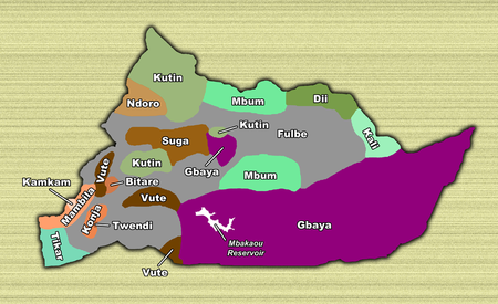
People
Language provides the most convenient means of categorising the Adamawa's ethnic groups. The greatest number of peoples speak various Southern Bantoid languagesSouthern Bantoid languages
In the classification of African languages, Southern Bantoid , also known as Wide Bantu or Bin, is a branch of the Bantoid languages of the Niger–Congo phylum...
. These Bantoid peoples primarily occupy the province's western third, in the Faro and Deo and the Mayo-Banyo divisions. The Ndoro are the northernmost, living on the Nigerian border on the upper Mayo Deo. To their south lie the Nyem-Nyem, called Suga by the Mbum, in the northern third of Mayo-Banyo division and along the west bank of the Meng River
Meng River
The Meng River originates from the "Red Wall" - gorge at 2,390 meters above sea level. It flows through the Gamperdonatal in a northern direction, where it unites in the municipality of Nenzing with the Ill. It reaches a length of 18 kilometers....
. The Vute live south of them on the Nigerian border and in a second population centre on the southwestern bank of the Mbarkaou Reservoir. The Mambila inhabit the southwestern border, and the Konja lie inland from them along the Banyo-Bankim road. The Tikar are at the province's southwestern corner, with territories extending into the neighbouring provinces.
Adamawa languages
The Adamawa languages are a putative family of 80–90 languages scattered across the Adamawa Plateau in central Africa, in Nigeria, Cameroon, Central African Republic, and Chad, spoken altogether by only one and a half million people . Joseph Greenberg classified them as one branch of the...
constitute the next major grouping. The Pere are farthest west of these, living in three main concentrations. The first is at the province's northwest, north of Mayo-Baleo town. They have another centre at the village of Paro south of Tignère
Tignère
-References:* * - Thèse de Donation Avele, Université Montesquieu Bordeaux IV * Charles Nanga, , Mémoire ENA....
, and their third grouping on the Meng River
Meng River
The Meng River originates from the "Red Wall" - gorge at 2,390 meters above sea level. It flows through the Gamperdonatal in a northern direction, where it unites in the municipality of Nenzing with the Ill. It reaches a length of 18 kilometers....
. The Kali at the province's northeast, along the North Province border centred at Bélél
Belel
-References:* * - Thèse de Donation Avele, Université Montesquieu Bordeaux IV * Charles Nanga, , Mémoire ENA....
. The Mbum
Mbum language
The Mbum are considered the original population of the Adamawa Plateau in Cameroon. That said, some histories recall that there were a people already in the area when they arrived there centuries ago...
(Mboum) are the last group, occupying the town of Ngaoundal
Ngaoundal
Ngaoundal is a town in the Adamawa Province of Cameroon. It is located at 6° 30" North, 13° 16" East. The town is home to a regional airport. Bauxite is mined nearby.- Transport :...
and its environs. East of Ngaoundéré are the Dii
Dii
The Dii were an independent Thracian tribe, swordsmen, who lived among the foothills of Mount Rhodope in Thrace. They often joined the ranks of organized armies as mercenaries or volunteers...
, who have larger territories in the North Province.
As speakers of an Ubangi language, the Gbaya make up another important grouping. Their territory spans the whole of the Mbéré division as well as a small area at the southwest of the Vina division. They continue south into the East Province.
The Fulbe make up an estimated 60% of the Adamawa's population. They are further subdivided into two subgroups: the sedentary, or town, Fulbe and the pastoral Fulbe, or Bororo. The sedentary Fulbe are more numerous and inhabit most of the province's major towns, including Banyo, Tibati
Tibati
Tibati is a town and commune in Djérem, Cameroon. The town and region are reigned by a local monarch, the Lamido.The most notable economic activity in the region is the fishery industry. The fish comes from the lake Mbakaou, a large dammed lake next to Tibati...
, Tignère
Tignère
-References:* * - Thèse de Donation Avele, Université Montesquieu Bordeaux IV * Charles Nanga, , Mémoire ENA....
, and Ngaoundéré, the capital. Over years of intermixing with native populations, they have come to physically resemble their Sudan
Sudan
Sudan , officially the Republic of the Sudan , is a country in North Africa, sometimes considered part of the Middle East politically. It is bordered by Egypt to the north, the Red Sea to the northeast, Eritrea and Ethiopia to the east, South Sudan to the south, the Central African Republic to the...
ese neighbours. The pastoral Fulbe create only temporary settlements, preferring instead to range across the province and beyond with large herds of cattle. These Fulbe are lighter skinned than their town brethren, tall and thin, with Arab-looking features.
The Fulbe speak a Cameroonian dialect of the Senegambian language Fulfulde
Fula language
The Fula or Fulani language is a language of West Africa. It is spoken as a first language by the and related groups from Senegambia and Guinea to Cameroon and Sudan...
. Due to their historical hegemony of the territory, it also serves as a lingua franca. Other major languages include Bitare, Dii
Dii language
The Dii language is a member of the Duru branch of Savanna languages. Yag Dii is the ethnonym....
, Gbaya, Mambila
Mambila language
Mambila is a Bantoid dialect chain stretching across Nigeria and Cameroon. Notable dialects are Barup, Bang, Dorofi, Gembu, Hainari, Kabri, Mayo Ndaga, Mbamnga, Tamien, Warwar ; Ju Ba, Sunu Torbi , Ju Naare , Langa...
, and Tikar
Tikar language
Tikar is a Bantoid language of uncertain classification spoken in Cameroon by the Bankim, Ngambe, and related Tikar peoples, as well as by the Bedzan Pygmies...
. Most educated inhabitants also speak French.
Religion
Islam reigns supreme in the Adamawa, especially among the Fulbe majority. Even among them, however, there is a noted difference between the sedentary Fulbe, who are more religious, and the nomadic Bororo, who are often only nominally Muslim. ChristianityChristianity
Christianity is a monotheistic religion based on the life and teachings of Jesus as presented in canonical gospels and other New Testament writings...
has made some inroads, though Christians are in a distinct minority. Many of the tribes retain animist, or "pagan
Paganism
Paganism is a blanket term, typically used to refer to non-Abrahamic, indigenous polytheistic religious traditions....
", beliefs, particularly in the mountains near the Nigerian border.
Livestock
The Adamawa's economy is based almost entirely on one single thing: cattleCattle
Cattle are the most common type of large domesticated ungulates. They are a prominent modern member of the subfamily Bovinae, are the most widespread species of the genus Bos, and are most commonly classified collectively as Bos primigenius...
, a Fulbe monopoly. The region's low population, high humidity, and vast fields of grass make it ideal for grazing. Herdsmen rotate pastures, and they often construct watering holes or wells for themselves and their animals.
The close relationship between the Bororo and their herds lends a great cultural importance to a Fulbe's number of cattle, and the more heads of cattle a man has, the wealthier he is. This often leads herders to never kill their animals, however, and to keep sick animals alive for fear of losing a portion of one's net worth. Nevertheless, many Fulbe herders transport their cattle to the big markets of Yaoundé
Yaoundé
-Transportation:Yaoundé Nsimalen International Airport is a major civilian hub, while nearby Yaoundé Airport is used by the military. Railway lines run west to the port city of Douala and north to N'Gaoundéré. Many bus companies operate from the city; particularly in the Nsam and Mvan neighborhoods...
and Douala
Douala
Douala is the largest city in Cameroon and the capital of Cameroon's Littoral Province. Home to Cameroon's largest port and its major international airport, Douala International Airport, it is the commercial capital of the country...
for sale (some make it as far as Gabon
Gabon
Gabon , officially the Gabonese Republic is a state in west central Africa sharing borders with Equatorial Guinea to the northwest, Cameroon to the north, and with the Republic of the Congo curving around the east and south. The Gulf of Guinea, an arm of the Atlantic Ocean is to the west...
and Congo
Republic of the Congo
The Republic of the Congo , sometimes known locally as Congo-Brazzaville, is a state in Central Africa. It is bordered by Gabon, Cameroon, the Central African Republic, the Democratic Republic of the Congo , the Angolan exclave province of Cabinda, and the Gulf of Guinea.The region was dominated by...
). The major transhumance
Transhumance
Transhumance is the seasonal movement of people with their livestock between fixed summer and winter pastures. In montane regions it implies movement between higher pastures in summer and to lower valleys in winter. Herders have a permanent home, typically in valleys. Only the herds travel, with...
paths are in the western third of the province and at the border with Chad.
Most of these animals are of the humpbacked zebu
Zebu
Zebu , sometimes known as humped cattle, indicus cattle, Cebu or Brahmin cattle are a type of domestic cattle originating in South Asia, particularly the Indian subcontinent. They are characterised by a fatty hump on their shoulders, drooping ears and a large dewlap...
breed. Near Ngaoundéré and Banyo, these are called Peul zebu, large and meaty animals with dark-brown hides and white spots. The nomadic Fulbe, on the other hand, herd Bororo zebu. These are leaner, lighter-coloured beasts that are better able to travel long distances.
The government-run Institut de Récherche Zootechniques (IZR) and SODEPA have established a handful of modern cattle ranches, as well. The major ones are near the villages of Laro
Laro
Laro is an ethnic minority in Sudan. The population of this minority is at several 10,000. Many members of this minority are Christians. Their traditional home is the Nuba Hills. They speak Laro, a Niger–Congo language....
, Wakwo and Ndokayo. Here, ranchers have bred
Animal husbandry
Animal husbandry is the agricultural practice of breeding and raising livestock.- History :Animal husbandry has been practiced for thousands of years, since the first domestication of animals....
new breeds of cattle by mixing native Fulbe animals with the American Brahmin
Brahmin
Brahmin Brahman, Brahma and Brahmin.Brahman, Brahmin and Brahma have different meanings. Brahman refers to the Supreme Self...
. Government initiatives have also been instrumental in the eradication of the tsetse fly
Tsetse fly
Tsetse , sometimes spelled tzetze and also known as tik-tik flies, are large biting flies that inhabit much of mid-continental Africa between the Sahara and the Kalahari deserts. They live by feeding on the blood of vertebrate animals and are the primary biological vectors of trypanosomes, which...
in the region.
Many ranchers and Bororo also raise horse
Horse
The horse is one of two extant subspecies of Equus ferus, or the wild horse. It is a single-hooved mammal belonging to the taxonomic family Equidae. The horse has evolved over the past 45 to 55 million years from a small multi-toed creature into the large, single-toed animal of today...
s and donkey
Donkey
The donkey or ass, Equus africanus asinus, is a domesticated member of the Equidae or horse family. The wild ancestor of the donkey is the African Wild Ass, E...
s. In addition, the Adamawa has more goat
Goat
The domestic goat is a subspecies of goat domesticated from the wild goat of southwest Asia and Eastern Europe. The goat is a member of the Bovidae family and is closely related to the sheep as both are in the goat-antelope subfamily Caprinae. There are over three hundred distinct breeds of...
s and sheep than any other province, as these can live even in the larger towns. Pig
Pig
A pig is any of the animals in the genus Sus, within the Suidae family of even-toed ungulates. Pigs include the domestic pig, its ancestor the wild boar, and several other wild relatives...
s, however, are much less common due to the prevalence of Islam in the region.
Agriculture
Nearly all farming in the province is done at the sustenanceSubsistence agriculture
Subsistence agriculture is self-sufficiency farming in which the farmers focus on growing enough food to feed their families. The typical subsistence farm has a range of crops and animals needed by the family to eat and clothe themselves during the year. Planting decisions are made with an eye...
level. Millet
Millet
The millets are a group of small-seeded species of cereal crops or grains, widely grown around the world for food and fodder. They do not form a taxonomic group, but rather a functional or agronomic one. Their essential similarities are that they are small-seeded grasses grown in difficult...
is the mainstay, though maize
Maize
Maize known in many English-speaking countries as corn or mielie/mealie, is a grain domesticated by indigenous peoples in Mesoamerica in prehistoric times. The leafy stalk produces ears which contain seeds called kernels. Though technically a grain, maize kernels are used in cooking as a vegetable...
, and manioc
Cassava
Cassava , also called yuca or manioc, a woody shrub of the Euphorbiaceae native to South America, is extensively cultivated as an annual crop in tropical and subtropical regions for its edible starchy tuberous root, a major source of carbohydrates...
are also important. Other crops, grown in smaller quantities, include cocoyam
Xanthosoma
Xanthosoma is a genus of about 50 species of tropical and sub-tropical arums in the flowering plant family, Araceae, all native to tropical America...
s, yams
Yam (vegetable)
Yam is the common name for some species in the genus Dioscorea . These are perennial herbaceous vines cultivated for the consumption of their starchy tubers in Africa, Asia, Latin America and Oceania...
, and groundnut
Peanut
The peanut, or groundnut , is a species in the legume or "bean" family , so it is not a nut. The peanut was probably first cultivated in the valleys of Peru. It is an annual herbaceous plant growing tall...
s.
The Gbaya, Mbum, and Dourou
Dourou
Dourou is a small town and commune in the Cercle of Bandiagara in the Mopti Region of Mali. As of 1998 the commune had a population of 14,127....
are the region's most prolific farmers, though even the herdsmen farm in the rainy season. Farms are typically small plots that are cleared or burned out of the brush and then planted during the dry season. Crops grow during the rainy season, when they are harvested. Because the dry season is so long, crops must be preserved, so most are transformed into grain
Cereal
Cereals are grasses cultivated for the edible components of their grain , composed of the endosperm, germ, and bran...
, which is pounded by hand with mortar and pestle.
Cash crop
Cash crop
In agriculture, a cash crop is a crop which is grown for profit.The term is used to differentiate from subsistence crops, which are those fed to the producer's own livestock or grown as food for the producer's family...
s play a small role in the region's economy. SODEBLE grows wheat
Wheat
Wheat is a cereal grain, originally from the Levant region of the Near East, but now cultivated worldwide. In 2007 world production of wheat was 607 million tons, making it the third most-produced cereal after maize and rice...
on 100 km² at Wassandé, near Ngaoundéré. The southwestern Mayo-Banyo division also has some coffee
Coffee
Coffee is a brewed beverage with a dark,init brooo acidic flavor prepared from the roasted seeds of the coffee plant, colloquially called coffee beans. The beans are found in coffee cherries, which grow on trees cultivated in over 70 countries, primarily in equatorial Latin America, Southeast Asia,...
plots. Other interests have established groundnut, millet, and wheat plantation
Plantation
A plantation is a long artificially established forest, farm or estate, where crops are grown for sale, often in distant markets rather than for local on-site consumption...
s in recent years.
Industry
The Adamawa has a bit of industryIndustry
Industry refers to the production of an economic good or service within an economy.-Industrial sectors:There are four key industrial economic sectors: the primary sector, largely raw material extraction industries such as mining and farming; the secondary sector, involving refining, construction,...
, most located in the capital. Much of this is tied to the region's cattle-based economy. For example, leatherworking is an important industry in Ngaoundéré, as evidenced by the Société des Tanneries et Peausseries du Cameroun (STPC) factory. Rubber
Rubber
Natural rubber, also called India rubber or caoutchouc, is an elastomer that was originally derived from latex, a milky colloid produced by some plants. The plants would be ‘tapped’, that is, an incision made into the bark of the tree and the sticky, milk colored latex sap collected and refined...
, perfume
Perfume
Perfume is a mixture of fragrant essential oils and/or aroma compounds, fixatives, and solvents used to give the human body, animals, objects, and living spaces "a pleasant scent"...
, and dairy product
Dairy product
Dairy products are generally defined as foods produced from cow's or domestic buffalo's milk. They are usually high-energy-yielding food products. A production plant for such processing is called a dairy or a dairy factory. Raw milk for processing comes mainly from cows, and, to a lesser extent,...
s are also processed in the capital. Handicrafts, including woodworking
Woodworking
Woodworking is the process of building, making or carving something using wood.-History:Along with stone, mud, and animal parts, wood was one of the first materials worked by early humans. Microwear analysis of the Mousterian stone tools used by the Neanderthals show that many were used to work wood...
and mat weaving
Weaving
Weaving is a method of fabric production in which two distinct sets of yarns or threads are interlaced at right angles to form a fabric or cloth. The other methods are knitting, lace making and felting. The longitudinal threads are called the warp and the lateral threads are the weft or filling...
, form another sector. Tin
Tin
Tin is a chemical element with the symbol Sn and atomic number 50. It is a main group metal in group 14 of the periodic table. Tin shows chemical similarity to both neighboring group 14 elements, germanium and lead and has two possible oxidation states, +2 and the slightly more stable +4...
is mined
Mining
Mining is the extraction of valuable minerals or other geological materials from the earth, from an ore body, vein or seam. The term also includes the removal of soil. Materials recovered by mining include base metals, precious metals, iron, uranium, coal, diamonds, limestone, oil shale, rock...
near Mayo Darlé and the Nigerian border and southwest of Banyo, and bauxite
Bauxite
Bauxite is an aluminium ore and is the main source of aluminium. This form of rock consists mostly of the minerals gibbsite Al3, boehmite γ-AlO, and diaspore α-AlO, in a mixture with the two iron oxides goethite and hematite, the clay mineral kaolinite, and small amounts of anatase TiO2...
is mined near Ngaoundal
Ngaoundal
Ngaoundal is a town in the Adamawa Province of Cameroon. It is located at 6° 30" North, 13° 16" East. The town is home to a regional airport. Bauxite is mined nearby.- Transport :...
and Minim-Martap. Mineral water
Mineral water
Mineral water is water containing minerals or other dissolved substances that alter its taste or give it therapeutic value, generally obtained from a naturally occurring mineral spring or source. Dissolved substances in the water may include various salts and sulfur compounds...
is obtained at Doungué.
Transport
Ngaoundéré is the gateway to the province, and it is most easily accessible from southern Cameroon via the "Transcam II" rail line. The trip takes between 12 and 30 hours, but the presence of couchettes makes the journey bearable for those who can afford them. Other passengers are crammed into all available seats, however, including those in the dining car. Due to the overcrowded conditions, thieves are another hazard.Road travel from the south is also possible, but this is limited to poor roads from the Centre Province or else a long detour through the East Province, where the roads are not much better. Roads within the Adamawa itself are mostly unpaved and are often in poor condition (particularly south of Ngaoundéré) due to little maintenance. The road north from Ngaoundéré into the North Province is paved, however, meaning that those traveling via train can continue to the North and Far North without too much discomfort. National Road 6 enters the province from Foumban
Foumban
Foumban or Fumban is a city in Cameroon, lying north east of Bafoussam. It has a population of 83,522 . It is a major town for the Bamoun people and is home to a museum of traditional arts and culture...
in the West Province and continues on to Banyo, Tibati, and Meïganga. National Road 15 comes from Sangbé in the Centre Province to Tibati and on to Ngaoundéré.
A regional airport services Ngaoundéré with flights to Yaoundé, Douala, Garoua
Garoua
Garoua is the capital of the North Province of Cameroon, lying on the Benue River. The city had 235,996 inhabitants at the 2005 Census, and is an important river port.- Overview :...
, and Maroua
Maroua
Maroua is the capital of the Far North Region of Cameroon, on the Ferngo and Kaliao Rivers. The city had 201,371 inhabitants at the 2005 Census,and is a centre of cotton industry. The city also has an airport located near the town of Salak, an agricultural school and ethnographic museum. To the...
. Tignère, Banyo, Ngaoundal, Tibati, and the Mbakaou Reservoir all have airstrips.
Tourism
Most travellers see the Adamawa only briefly as they transition at Ngaoundéré from the train to a bus further north. The province does see some visitors who are interested in the region's rich cultural history. A number of lamidoLamido
Lamido is the Anglicisation of a term from the Fula language or Fulfulde, used to refer to a ruler. In the language it is properly laamiiɗo , derived from the verbal root "laam-" meaning "to rule or to lead", and hence may be translated more specifically as "leader"...
s allow tourists to visit their palaces, for example, such as the ruler of Ngo, who receives nobles every Friday and Sunday. The province also has numerous scenic destinations ranging form crater lakes to caves and waterfalls.
Administration and social conditions
What social inequalities exist in the Adamawa largely stem from the region's high level of cultural homogeneity. Most people in the province are Muslim Fulbe, and those who are not often fall prey to racism and discrimination, especially in more rural areas. The Cameroonian government has made efforts to encourage the region's nomads to settle, but so far has made little progress.With its low population, the Adamawa holds little import to Cameroonian politicians. However, the Fulbe tribe is spread throughout the country, especially in the three northern provinces, and together they form a significant bloc that Cameroonian politicians cannot easily ignore. This is one way that Cameroon's greater north is able to oppose policies more favourable to the south.
Government
- DjéremDjéremDjérem is a department of Adamawa Province in Cameroon.The department covers an area of 13,283 km² and as of 2001 had a total population of 89,382.The capital of the department lies at Tibati.-Subdivisions:...
, with its capital at TibatiTibatiTibati is a town and commune in Djérem, Cameroon. The town and region are reigned by a local monarch, the Lamido.The most notable economic activity in the region is the fishery industry. The fish comes from the lake Mbakaou, a large dammed lake next to Tibati... - Faro-et-DéoFaro-et-DéoFaro-et-Déo is a department of Adamawa Province in Cameroon.The department covers an area of 10,435 km² and as of 2001 had a total population of 66,442.The capital of the department lies at Tignere.-Subdivisions:...
, with its headquarters in TignèreTignère-References:* * - Thèse de Donation Avele, Université Montesquieu Bordeaux IV * Charles Nanga, , Mémoire ENA.... - Mayo-BanyoMayo-BanyoMayo-Banyo is a department of Adamawa Province in Cameroon.The department covers an area of 8,520 km² and as of 2001 had a total population of 134,902.The capital of the department lies at Banyo.-Subdivisions:...
, with its capital in Banyo - MbéréMbéréMbéré is a department of Adamawa Province in Cameroon.The department covers an area of 14,267 km² and as of 2001 had a total population of 185,473.The capital of the department lies at Meinganga.-Subdivisions:...
, headed from MeïgangaMeigangaMeiganga is a town in the Adamawa Province of Cameroon. It is located at around . Its estimated population in 2001 is 71,000.... - Vina, governed from NgaoundéréNgaoundéréNgaoundéré or N'Gaoundéré is the capital of the Adamawa Region of Cameroon. It had a population of 152,698 . It lies at the northern end of the railway to Yaoundé and is also home to an airport. The current city was founded in approximately 1835 by the Fulani leader Ardo Njobdi, although the...
A presidentially appointed prefect
Prefect
Prefect is a magisterial title of varying definition....
(), or senior divisional officer, governs each of these. The president also appoints the governor
Governor
A governor is a governing official, usually the executive of a non-sovereign level of government, ranking under the head of state...
, whose offices are in Ngaoundéré.
Traditional political organisation
Lamidos, traditional Muslim rulers, still hold great sway over their Fulbe subjects. Most large towns in the province have a lamido, and many smaller villages do as well. The various lamidos elect councilors to serve them; these may come from both Fulbe and other tribal groups. The Cameroonian government permits these rulers to hold their own courts and to keep their own jails, something human rights groups have pointed to as problematic.Most other tribes in the region are nominally under the rule of a chief
Tribal chief
A tribal chief is the leader of a tribal society or chiefdom. Tribal societies with social stratification under a single leader emerged in the Neolithic period out of earlier tribal structures with little stratification, and they remained prevalent throughout the Iron Age.In the case of ...
. However, these men are mostly just figureheads today. Among the Tikar, however, these individuals still hold a substantial amount of power. A group of advisers, or "Council of Notables", serves each Tikar chief. Below them are various ward heads () who govern a specific portion of a village or town. The quarter chiefs () hold sway over a particular neighbourhood.
Education
The Adamawa's education level is generally very low. The nomadic Bororo rarely send their children to school. Meanwhile, town Fulbe often marry their daughters off early into puberty, and married girls do not go to school. The province has an estimated 80% illiteracy rate.Another obstacle is lack of schools and teachers. Most schools are located in larger towns or in the capital, meaning that students often must travel long distances or live away from home, particularly at the secondary
Secondary education
Secondary education is the stage of education following primary education. Secondary education includes the final stage of compulsory education and in many countries it is entirely compulsory. The next stage of education is usually college or university...
level. In addition, Cameroonian teachers who are assigned to the province often refuse to go on account of its remoteness.
Health
Most of the Adamawa's towns have some form of health provider, if only a small clinic. The capital also has a hospital. The region's major health concern is lack of sanitationSanitation
Sanitation is the hygienic means of promoting health through prevention of human contact with the hazards of wastes. Hazards can be either physical, microbiological, biological or chemical agents of disease. Wastes that can cause health problems are human and animal feces, solid wastes, domestic...
. This is especially pronounced in the increasingly urbanised Ngaoundéré. Another concern is HIV
HIV
Human immunodeficiency virus is a lentivirus that causes acquired immunodeficiency syndrome , a condition in humans in which progressive failure of the immune system allows life-threatening opportunistic infections and cancers to thrive...
and AIDS
AIDS
Acquired immune deficiency syndrome or acquired immunodeficiency syndrome is a disease of the human immune system caused by the human immunodeficiency virus...
. Official government figures give the province an HIV-infection rate of 17%, the highest in the country. These numbers come from samples in Ngaoundéré only, however, and infection rates in more rural areas are probably lower.
Cultural life
The Adamawa maintains a lively traditional culture. One notable example is the Menang, a Tikar dance. Performers may dance for any number of reasons, from aiding warriors to celebrating women's sensuality. Births, funerals, and weddings are often occasion for grand celebration among the region's non-Muslim populations, as well.Early population movements
The Adamawa's oldest populations were various Paleo-Sudanese peoples. These were mostly displaced or absorbed by invading Sudanese groups in the 8th or 9th century. These included the Mbum (Mboum), Ndoro (Dourou), Kutin, (Koutine), Laka-Mbere, ChambaChamba people
The Chamba people of Nigeria and Cameroon that speak two distantly related languages: Chamba Leko, of the Leko–Nimbari languages, and Chamba Daka, of the Dakoid languages...
, Doayo, Fali
Fali
-Languages:*Fali language , a language of Nigeria*Fali of Kirya, also a Chadic language of Nigeria*Fali language of Baissa, an unrelated language of Nigeria*Fali languages , a language or languages of Cameroon-People:*Fali people...
, Mundang (Moundang), and Tupuri
Tupuri people
The Tupuri are an ethnic group in Cameroon and Chad. They speak a language called Tupuri, which had 125,000 speakers in Cameroon at an unspecified date and 90,785 speakers in Chad in 1993. In Cameroon, the Tupuri live east of Kaélé in the Kaele division and in the Kar-Hay subdivison of the...
(Toupouri).
The Kanem-Bornu Empire
Kanem Empire
The Kanem Empire was located in the present countries of Chad, Nigeria and Libya. At its height it encompassed an area covering not only much of Chad, but also parts of southern Libya , eastern Niger and north-eastern Nigeria...
of Lake Chad had relations with these tribes. They called the area Fumbina or Mabina (a name which denoted the present province as well as territories in present-day Nigeria and the Central African Republic). The Kanem-Bornu also introduced Islam to the region between 1349 and 1385 by way of the Islamic centre at Kano
Kano
Kano is a city in Nigeria and the capital of Kano State in Northern Nigeria. Its metropolitan population is the second largest in Nigeria after Lagos. The Kano Urban area covers 137 sq.km and comprises six Local Government Area - Kano Municipal, Fagge, Dala, Gwale, Tarauni and Nassarawa - with a...
in present-day Nigeria. However, no more than a few rulers, nobles or merchants ever converted.
Many more tribes entered the territory from the region of Chad between the 14th and 17 centuries. These included the Semi-Bantu tribes, such as the Bamileke
Bamileke
The Bamileke is a folk whose native ancestral area is in the western highlands of Cameroon's West Province, west of the Noun River and southeast of the Bamboutos Mountains and in the Moungo region of the Littoral, Southwest, and Centre Provinces. They are a part of the Semi-Bantu ethnic groups...
, Bamun
Bamum people
The Bamum, sometimes called Bamoum, Bamun, Bamoun, or Mum, are an ethnic group of Cameroon with around 215,000 members.-Religion:...
, Kom, Nso
Nso
The Nso are a people of the Bamenda Grassfields in the Northwest Region of Cameroon. Their traditional language is Lamnso and their capital is Kumbo...
, Tikar, Widikum, and Wimbam. The Bantu came as well, examples being the Beti-Pahuin
Beti-Pahuin
The Beti-Pahuin are a group of related peoples who inhabit the rain forest regions of Cameroon, Republic of the Congo, Equatorial Guinea, Gabon, and São Tomé and Príncipe. Though they separate themselves into several individual ethnic groups, they all share a common history and culture. They were...
and Maka
Maka people
The Maka or Makaa are an ethnic group inhabiting the southern rain forest zone of Cameroon. They live primarily in the northern portions of the Upper Nyong division of Cameroon's East Province. Major Maka settlements include Abong-Mbang, Doumé, and Nguélémendouka...
and Njem
Njem
The Njyem are an ethnic group inhabiting the rain forest zone of southern Cameroon and northern Republic of the Congo. In Cameroon, the Njyem live along the road running south from Lomié, passing the government center of Ngoyla and going as far south as Djadom. From there, footpaths extend to...
. Other groups who came were the Gbaya, from the present CAR, and the Vute, from the Lake Chad region. The Vute were region's first iron workers, and they founded the towns of Mbamnyang (present Banyo) and Tibaré (present Tibati). The Semi-Bantu peoples gradually moved south before settling near the headwaters of the Mbam River sometime between the 17th and 19th centuries. The Bantu settled east of them, south of the Adamawa Plateau. One or all of these populations founded Banyo, Tibati, and Ngaoundéré.
Meanwhile, the Bantu and Semi-Bantu invasions drove the longer-established Sudanese peoples north. The Mbum, Ndoro, Kutin, and Laka-Mbere moved to the present-day province's northern reaches, while the other Sudanese migrated even farther. This period marked the highest population for the Adamawa territory until modern times. However, one event had drastic consequences for the region: the arrival of the Fulbe.
Fulbe jihads
Early Fulbe settlers entered the Adamawa from present-day Nigeria or northern Cameroon as early as the 13th century. These settlers and nomads were never numerous, however, and they often held subservient status to other tribes. Over time, however, the steady stream of Fulbe immigrants allowed Fulbe communities to spring up in many areas. These early Fulbe converted to Islam sometime in the 17th century, beginning with the settled, or town, Fulbe.In 1804, Fulbe in the territory and beyond were growing disenchanted with submission to pagan tribes. They were also hungry for larger territories that they could use for cattle grazing. The Fulbe leader Usman dan Fodio
Usman dan Fodio
Shaihu Usman dan Fodio , born Usuman ɓii Foduye, was the founder of the Sokoto Caliphate in 1809, a religious teacher, writer and Islamic promoter. Dan Fodio was one of a class of urbanized ethnic Fulani living in the Hausa States in what is today northern Nigeria...
responded to this sentiment and called a jihad
Jihad
Jihad , an Islamic term, is a religious duty of Muslims. In Arabic, the word jihād translates as a noun meaning "struggle". Jihad appears 41 times in the Quran and frequently in the idiomatic expression "striving in the way of God ". A person engaged in jihad is called a mujahid; the plural is...
. Usman named his lieutenant Modima Adam Al-Hasan, or Modibo Adama
Modibo Adama
Adama bi Ardo Hassana , more commonly known as Modibo Adama, was a Fulani scholar and holy warrior. He led a jihad into the region of Fumbina , opening the region for Fulani colonisation...
, lamido of Fumbina, and Adama quickly raised an army in the territory.
Adama's forces proved all but unstoppable. He conquered major Vute centres at Mbamnyang and Tibaré in 1835, which he renamed Banyo and Tibati. At Adama's death in 1847, Fulbe horsemen controlled territory from the Niger River to the west and the Logone to the east and from the Sahara
Sahara
The Sahara is the world's second largest desert, after Antarctica. At over , it covers most of Northern Africa, making it almost as large as Europe or the United States. The Sahara stretches from the Red Sea, including parts of the Mediterranean coasts, to the outskirts of the Atlantic Ocean...
to the north and the Sanaga River to the south to form the Sokoto Caliphate. Adama's emirate was divided into districts under governors; the Adamawa Plateau fell into the Ngaoundéré subdivision.
Fighting against native peoples continued for many years. Around 1830, the Fulbe conquered the Mbum village of Delbé, which they renamed Ngaoundéré, after a nearby hill. Many Mbum converted to Islam and remained, though many others migrated north. The town became the seat of the lamidat of Ardo Ndjobdi.
Beginning around 1835, Fulbe immigrants streamed into the newly conquered territories in large numbers. By 1850, the Fulbe were firmly entrenched in northern Cameroon. Native populations were subjugated and placed under the rule of the local lamidos. Native populations were forced to convert to Islam, face enslavement, or flee. Fulbe merchants accepted salt and horses from North Africa
North Africa
North Africa or Northern Africa is the northernmost region of the African continent, linked by the Sahara to Sub-Saharan Africa. Geopolitically, the United Nations definition of Northern Africa includes eight countries or territories; Algeria, Egypt, Libya, Morocco, South Sudan, Sudan, Tunisia, and...
in exchange for slaves for sale in the Muslim empires to the north. A smaller number of slaves went south for the trans-Atlantic market.
Those groups who resisted had no choice but to flee to the unforgiving mountains or else to the jungle south. Those groups who were immediate neighbours to the warring Fulbe, such as the Vute and Gbaya, dislodged others who lay in their path, such as Cameroon's Bantu peoples. The Fulbe jihads thus served as the single most important event in the peopling of southern Cameroon. The jihad only served to depopulate Cameroon's north, however. The Fulbe invaders did not set up new settlements. Rather, they used their conquered lands as pasture for their cattle. Many of these groups were still migrating when they came into contact with Cameroon's new colonisers: The Germans
Germany
Germany , officially the Federal Republic of Germany , is a federal parliamentary republic in Europe. The country consists of 16 states while the capital and largest city is Berlin. Germany covers an area of 357,021 km2 and has a largely temperate seasonal climate...
.
European contacts
BritishGreat Britain
Great Britain or Britain is an island situated to the northwest of Continental Europe. It is the ninth largest island in the world, and the largest European island, as well as the largest of the British Isles...
explorers were the first Europeans to enter Adamawa territory when they came in 1822. The German Dr. Gustav Nachtigal
Gustav Nachtigal
Gustav Nachtigal was a German explorer of Central and West Africa. He is further known as the German Empire's consul-general for Tunisia and Commissioner for West Africa. His mission as commissioner resulted in Togoland and Kamerun becoming the first colonies of a German colonial empire...
was the first Westerner to explore the region extensively, which he did between 1869 and 1873. Nachtigal kept a keen eye out to notice what groups lived in the region, what their relations were like with their neighbours, and what resources could possibly be exploited from the area. The British Eduard E. Flegel followed Nachtigal in 1882. He explored the Adamawa emirate, setting up trade and reaching as far south as Banyo. He died in 1883, however, still on expedition, and peaceful contact between the West and the Fulbe empire came to an end. Instead, Germany annexed part of Adama's empire in 1884, and other part became part of British Nigeria. As far as Europe was concerned, the Adama emirate no longer existed.
German administration
The Fulbe fiercely opposed German hegemony. The German governor Jesko von PuttkamerJesko von Puttkamer
Jesko Albert Eugen von Puttkamer was a German colonial military chief, and nine times governor of Kamerun:*13 May 1887 - 4 October 1887*14 August 1890 - 2 December 1890*31 December 1894 - 27 March 1895...
sent soldiers under Captain Von Kamptz to suppress the uprisings, and on 7 May 1899, Banyo became the first major town to surrender. Tibati fell a month later, and Ngaoundéré followed on 20 September 1901. The Adamawa Plateau was now largely pacified, and the Germans pushed north toward the important trade town of Garoua.
Germany eventually prevailed against the Fulbe, and the present Adamawa fell into the Ngaoundéré administrative area, or "residency". From 1902 to 1903, Germany allowed most lamidos to stay in power, albeit under German supervision; rulers who refused to cooperate were replaced. The colonials also encouraged the Islamisation
Islamization
Islamization or Islamification has been used to describe the process of a society's conversion to the religion of Islam...
of the area's non-Muslim inhabitants, as this would place them under the rule of the lamidos, who were already submissive to the German governor.
French administration
Germany's 1916 defeat in Africa in World War IWorld War I
World War I , which was predominantly called the World War or the Great War from its occurrence until 1939, and the First World War or World War I thereafter, was a major war centred in Europe that began on 28 July 1914 and lasted until 11 November 1918...
eventually gave control of the territory to the French
France
The French Republic , The French Republic , The French Republic , (commonly known as France , is a unitary semi-presidential republic in Western Europe with several overseas territories and islands located on other continents and in the Indian, Pacific, and Atlantic oceans. Metropolitan France...
, the region's third occupying force in less than a century. The new governors placed the region in the Mora-Garoua administrative area with its capital at Garoua.
French colonial policies varied little from their German predecessors. Lamidos were left in nominal power, though they were expected to carry out French policies. France also did away with recalcitrant rulers, and by 1936, the region had 39 lamidos and one sultan
Sultan
Sultan is a title with several historical meanings. Originally, it was an Arabic language abstract noun meaning "strength", "authority", "rulership", and "dictatorship", derived from the masdar سلطة , meaning "authority" or "power". Later, it came to be used as the title of certain rulers who...
. France's main contribution to the region was its improvements to infrastructure. Road construction, in particular, accelerated during French rule, and the colonials had a road built from Foumban to Garoua via Banyo, Tibati, and Ngaoundéré.
In 1956, France made all of its West African colonies self-governing. André-Marie Mbida
André-Marie Mbida
Andre-Marie Mbida was a Cameroonian State man, pragmatic nationalist, first Cameroonian to be elected Member of Parliament at the French National Assembly, Prime Minister of Cameroon, second African-born Prime Minister in the dark continent , first Head of State of French speaking autonomous...
became the first premier of Cameroon. Mbida quickly alienated the Muslim north, however, when he introduced his Abong-Mbang Resolutions. One of these called for the "democratisation" of northern Cameroon, which the Muslim rulers feared was code for bringing an end to their influence. Muslim leaders thus threatened to secede
Secession
Secession is the act of withdrawing from an organization, union, or especially a political entity. Threats of secession also can be a strategy for achieving more limited goals.-Secession theory:...
from Cameroon and join French Chad unless the resolutions were recalled. The events eventually led to Mbida's expulsion from the prime ministry and his replacement by Ahmadou Ahidjo
Ahmadou Ahidjo
Ahmadou Babatoura Ahidjo was the first President of Cameroon from 1960 until 1982.-Early life:Ahidjo was born in Garoua, a major river port along the Benue River in northern Cameroun, which was at the time a French mandate territory...
, a Muslim from the country's north.
Post-independence
Ahidjo became Cameroon's first president after the country's independence on 1 January 1960. He devoted substantial resources to developing his northern homeland, such as the extension of a road north from Yaoundé to better link Cameroon's north and south. The railroad followed soon thereafter, construction beginning in 1961 and reaching Ngaoundéré ten years later.The northern Muslims largely viewed the arrival of Cameroon's second president, Paul Biya
Paul Biya
Paul Biya is a Cameroonian politician who has been the President of Cameroon since 6 November 1982. A native of Cameroon's south, Biya rose rapidly as a bureaucrat under President Ahmadou Ahidjo in the 1960s, serving as Secretary-General of the Presidency from 1968 to 1975 and then as Prime...
, suspiciously. This was largely due to an Ahidjo partisan named Moussa Yaya, whom Biya and the press accused of trying to turn the lamidos against the new leader. Biya enjoys some support in the province today, but his popularity is nowhere near as strong as in Cameroon's south. Part of this is because Biya's main activities in the north have been minimal. He split the North Province into three parts in 1983, thus creating the Far North Region (Cameroon), North, and Adamawa Provinces as they exist today. He also absorbed the University of Ngaoundéré into the national system.