

Tourism in Chile
Encyclopedia
Chile
Chile ,officially the Republic of Chile , is a country in South America occupying a long, narrow coastal strip between the Andes mountains to the east and the Pacific Ocean to the west. It borders Peru to the north, Bolivia to the northeast, Argentina to the east, and the Drake Passage in the far...
has experienced sustained growth over the last decades. Chile received about 1.25 million foreign visitors in 2006, up to 2.50 million in 2007
The percentages of foreign tourists arrivals by land, air and sea were, respectively, 55.3%, 40.5% and 4.2% for that year. The two main gateways for international tourists visiting Chile are Comodoro Arturo Merino Benítez International Airport
Comodoro Arturo Merino Benítez International Airport
Comodoro Arturo Merino Benítez International Airport , also known as Pudahuel Airport and Santiago International Airport, located in Pudahuel, north-west of downtown Santiago, is Chile's largest aviation facility and the busiest international air passenger gateway to the country...
and Paso Los Libertadores
Paso Libertadores
The Paso Internacional Los Libertadores, also called Cristo Redentor, is a mountain pass in the Andes between Argentina and Chile. It is the main transport route out of Chilean capital city Santiago into Mendoza city in Argentina and so carries quite heavy traffic.From the Argentine side the...
.
Chile a great diversity of natural landscapes, from the Mars-like landscapes of the hyperarid Atacama Desert
Atacama Desert
The Atacama Desert is a plateau in South America, covering a strip of land on the Pacific coast, west of the Andes mountains. It is, according to NASA, National Geographic and many other publications, the driest desert in the world...
to the glacier-fed fjords of the Chilean Patagonia
Patagonia
Patagonia is a region located in Argentina and Chile, integrating the southernmost section of the Andes mountains to the southwest towards the Pacific ocean and from the east of the cordillera to the valleys it follows south through Colorado River towards Carmen de Patagones in the Atlantic Ocean...
, passing by the winelands backdropped by the Andes
Andes
The Andes is the world's longest continental mountain range. It is a continual range of highlands along the western coast of South America. This range is about long, about to wide , and of an average height of about .Along its length, the Andes is split into several ranges, which are separated...
of the Central Valley
Chilean Central Valley
The Central Valley , Intermediate Depression or Longitudinal Valley is the depression between the Chilean Costal Range and the Andes Mountains. The central valley should not be confused with Central Chile that encompasses part of the valley...
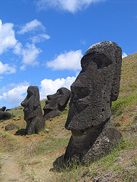
and the old-growth forests of the Lakes District. Easter Island
Easter Island
Easter Island is a Polynesian island in the southeastern Pacific Ocean, at the southeasternmost point of the Polynesian triangle. A special territory of Chile that was annexed in 1888, Easter Island is famous for its 887 extant monumental statues, called moai, created by the early Rapanui people...
and Juan Fernández Archipelago, including Robinson Crusoe Island
Robinson Crusoe Island
Robinson Crusoe Island , formerly known as Más a Tierra , or Aguas Buenas, is the largest island of the Chilean Juan Fernández archipelago, situated 674 kilometres west of South America in the South Pacific Ocean...
, are also major attractions.
Many of the most visited attractions in Chile are protected areas. The extensive Chilean protected areas
Protected areas of Chile
The protected areas of Chile are areas that have natural beauty or significant historical value protected by the government of Chile. These protected areas cover over , which is 19% of the territory of Chile...
system includes 32 national parks, 48 natural reserves and 15 natural monuments.
Since 2005 local people groups have been working on a project, Sendero de Chile, to create an 8,000 km trail throughout Zona Sur for bicycling and hiking. This trail demonstrates a shift from traditional tourism to ecotourism
Ecotourism
Ecotourism is a form of tourism visiting fragile, pristine, and usually protected areas, intended as a low impact and often small scale alternative to standard commercial tourism...
, and when complete will travel through various provinces and regions, primarily south of Zona Cental.
Norte Grande
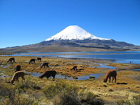
Norte Grande, Chile
The Norte Grande is one of the five natural regions into which CORFO divided continental Chile in 1950. It borders Peru to the north, the Pacific Ocean to the west, the Altiplano, Bolivia and Argentina to the east, and the Copiapó River to the south, beyond which lies the Norte Chico natural...
. A myriad of geoglyph
Geoglyph
A geoglyph is a large design or motif produced on the ground and typically formed by clastic rocks or similarly durable elements of the geography, such as stones, stone fragments, gravel, or earth...
s, petroglyph
Petroglyph
Petroglyphs are pictogram and logogram images created by removing part of a rock surface by incising, picking, carving, and abrading. Outside North America, scholars often use terms such as "carving", "engraving", or other descriptions of the technique to refer to such images...
s and pictographs attest the presence of ancient cultures in the area. Among the most remarkable are those of Azapa Valley
Azapa Valley
Azapa Valley in Chile is a fertile and narrow oasis, framed between two sere hills and divided by the summer season-running "San Jose" river . It is located three kilometers from Arica...
, Lluta Valley
Lluta River
The Lluta River is a river located in the northern part of the Arica and Parinacota Region of Chile. Its headwaters are on the western flanks of the Andes of the Parinacota Province, just a few kilometers south of the border with Peru, and empties into Pacific Ocean about 4 km north of the city of...
, the Atacama Giant
Atacama Giant
The Atacama Giant is a large anthropomorphic geoglyph in the Atacama Desert, Chile.Located at "Cerro Unitas", this is the largest prehistoric anthropomorphic figure in the world with a height of and represents a deity for the local inhabitants from 1000 to 1400 CE.The figure was an early...
and Pintados Geoglyphs, these latter are protected within Pampa del Tamarugal National Reserve
Pampa del Tamarugal National Reserve
Pampa del Tamarugal National Reserve is a nature reserve of northern Chile's Tarapacá Region located in the Pampa del Tamarugal, about east of Iquique.The reserve consists of three separate sectors: Zapiga, Bosque Nativo de La Tirana, and Pintados...
. R. P. Gustavo Le Paige Archaeological Museum
R. P. Gustavo Le Paige Archaeological Museum
R. P. Gustavo Le Paige Archaeological Museum is a museum located in San Pedro de Atacama, Chile. It houses a collection of about 380,000 pre-Columbian artifacts from the Atacameño culture. The museum is named after Jesuit missionary Father Gustavo Le Paige, who was its founder.This museum belongs...
and Archaeological Museum of San Miguel de Azapa are home to the most important collections of artifact
Artifact (archaeology)
An artifact or artefact is "something made or given shape by man, such as a tool or a work of art, esp an object of archaeological interest"...
s and mummies in Chile, including the famous Chinchorro mummies, the oldest mummies in the world. The extreme aridity of the Atacama has been a key factor in the preservation of such archaeological remains.
Arica
Arica, Chile
Arica is a commune and a port city with a population of 185,269 in the Arica Province of northern Chile's Arica and Parinacota Region, located only south of the border with Peru. The city is the capital of both the Arica Province and the Arica and Parinacota Region...
is a coastal city with beautiful beaches and is also a starting point for travelers heading east to Putre
Putre
Putre is a Chilean town and commune, capital of the Parinacota Province in the Arica-Parinacota Region. It is located east of Arica, at an altitude of...
for enjoying the majestic Puna
Central Andean dry puna
The Central Andean dry puna is an ecoregion, in the Montane grasslands and shrublands biome, located in the Andean High plateau, in South America...
landscape of Lauca National Park
Lauca National Park
Lauca National Park is located in Chile's far north, in the Andean range. It encompasses an area of 1,379 km² of altiplano and mountains, the latter consisting mainly of enormous volcanoes. Las Vicuñas National Reserve is its neighbour to the south. Both protected areas, along with Salar de Surire...
. Southward from Lauca, Volcán Isluga National Park
Volcán Isluga National Park
Volcán Isluga National Park is located in the Andes, in the Tarapacá Region of Chile, near Colchane and south of Lauca Biosphere Reserve. It covers 1,747 square kilometers, with elevations ranging between 2,100 and 5,550 meters. It is named after Volcán Isluga, which at 5,550 m, is the tallest...
includes ceremonial sites for the Aymara people.
Inland from Iquique
Iquique
Iquique is a port city and commune in northern Chile, capital of both the Iquique Province and Tarapacá Region. It lies on the Pacific coast, west of the Atacama Desert and the Pampa del Tamarugal. It had a population of 216,419 as of the 2002 census...
, the desolate pampas are home to a few scattered towns and villages. Among those, the most interesting is the ghost town of Humberstone
Humberstone and Santa Laura Saltpeter Works
Humberstone and Santa Laura Saltpeter Works are two former saltpeter refineries located in northern Chile. They were declared a UNESCO World Heritage Site in 2005.-Geography:...
. In this area the tamarugo forests of the Pampa del Tamarugal
Pampa del Tamarugal
Pampa del Tamarugal is a vast plain encompassing a significant portion of the Norte Grande, Chile, and originally named for the Prosopis tamarugo trees that used to cover its surface. It is located between the parallels 19°30’ and 22°15’ south latitude and is considered part of the Atacama Desert...
break the barren monotony of the landscape.
The altiplano of Norte Grande has a wide variety of natural scenery including salt flats, volcanoes, lakes and geysers. San Pedro de Atacama
San Pedro de Atacama
San Pedro de Atacama is a Chilean town and commune in El Loa Province, Antofagasta Region. It is located east of Antofagasta, some 106 km southeast of Calama and the Chuquicamata copper mine, overlooking the Licancabur volcano. It features a significant archeological museum, the R. P...
and surrounding area offer one of most spectacular combinations of archeology and awe-inspiring natural sights. San Pedro was the cradle of the Atacameño
Atacameño
The Atacameños are a Native American people who inhabited the Andean portion of the Atacama Desert, mainly in what is today Chile's Antofagasta Region. Their language is known as Kunza....
Culture. Villages with interesting cultural past are Caspana
Caspana
Caspana is a Chilean village located 85 km northeast of the city of Calama, in the gorge carved by the river that shared its name and that is a tributary of the Salado River. Agricultural terraces form part of the landscape of the area.-References:...
, Toconao
Toconao
Toconao is a village south of San Pedro de Atacama in the San Pedro de Atacama province of Chile's northern Antofagasta Region. It lies at an elevation of above sea level, close to the northeast margin of the Salar de Atacama....
, Socaire
Socaire
Socaire is a village located southeast of the town of San Pedro de Atacama, in the San Pedro de Atacama province of Chile's northern Antofagasta Region. It offers views overlooking the Salar de Atacama....
and Chiu Chiu. Notable are also the pre-Hispanic fortresses of Quitor, Lasana
Lasana
Lasana is a small village located northeast of the city of Calama in the Calama province of Chile's northern Antofagasta Region. It sits along the banks of the Loa River....
and Turi. Two popular destinations in this area are Valley of the Moon
Valle de la Luna (Chile)
Valle de la Luna is located west of San Pedro de Atacama, Chile in the Cordillera de la Sal, in the Atacama desert of Chile. It has various stone and sand formations which have been carved by wind and water. It has an impressive range of color and texture, looking somewhat similar to the surface...
, so-named because its landscape resembles the moon, and El Tatio
El Tatio
thumb|A geyser bubbling at El Tatio geyser fieldEl Tatio is a geyser field located within the Andes Mountains of northern Chile at 4,200 meters above mean sea level. Contrary to some reports, it is not the highest-elevation geyser field in the world. Puchuldiza Geyser Field, Chile, and possibly...
Geysers.
Antofagasta
Antofagasta
Antofagasta is a port city in northern Chile, about north of Santiago. It is the capital of Antofagasta Province and Antofagasta Region. According to the 2002 census, the city has a population of 296,905...
is the largest city in Norte Grande. La Portada
La Portada
La Portada is a natural arch on the coast of Chile, north of Antofagasta. It is one of fifteen natural monuments included among the protected areas of Chile....
, a stunning natural arch
Natural arch
A natural arch or natural bridge is a natural geological formation where a rock arch forms, with an opening underneath. Most natural arches form as a narrow ridge, walled by cliffs, become narrower from erosion, with a softer rock stratum under the cliff-forming stratum gradually eroding out until...
, is located a short drive from Antofagasta.
Pan de Azúcar National Park
Pan de Azúcar National Park
Pan de Azúcar National Park is a national park of Chile. The park straddles the border between the Antofagasta Region and the Atacama Region. Its name, Parque Nacional Pan de Azúcar, means "sugar loaf".-Geography:...
is a park where sea and desert meet.
Norte Chico
Norte Chico, Chile
The Norte Chico is one of the five natural regions on which CORFO divided continental Chile in 1950. Its northern border is formed by the limit with the Far North, on west lies the Pacific Ocean, by the east the Andes mountains and Argentina, and by the south the Zona Central natural region...
are home to many of the highest volcanoes in the world, the highlight being Ojos del Salado
Ojos del Salado
Nevado Ojos del Salado is a massive stratovolcano in the Andes on the Argentina-Chile border and the highest volcano in the world at . It is also the second highest mountain in the Western Hemisphere and Southern Hemisphere and the highest in Chile...
. Apart from Ojos del Salado and the rest of the volcanoes, attractions in this portion of the Andes include Nevado Tres Cruces National Park
Nevado Tres Cruces National Park
Located in the Atacama Region of Chile at 93.2 miles from Copiapó. Nevado Tres Cruces National Park includes Laguna Santa Rosa, Laguna del Negro Francisco, and a part of the Salar de Maricunga. The park is divided into two zones, the northern zone encompasing the southern portion of Salar de...
and Laguna Verde
Laguna Verde (lake of Chile)
Laguna Verde is a salt lake in the Andes Mountains of Chile. It lies in the Atacama Region , near San Francisco Pass. The volcano Ojos del Salado marks the south border of its basin.High mountains surround the lake...
.
Norte Chico boasts some of the best beaches and exclusive coastal resorts in the country, such as Bahía Inglesa
Bahía Inglesa
Bahia Inglesa is a village and beach located near the port of Caldera in Atacama Region, Chile.With a population of 135 inhabitants , it owes its name to the visit of the English privateer Edward Davis. Bahia Inglesa is renowned for its white sands and warm waters, as well as its accommodations...
and those of La Serena.
The clear skies of Norte Chico and its world-renowned infrastructure have made ideal for astronomical tourism.
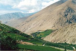
Elqui Valley is a very popular destination. Here, the dazzling green of the valley floor contrasts nicely with the barren brown slopes of the mountains that flank it.
Zona Central
Wine tourism
Wine tourism refers to tourism whose purpose is or includes the tasting, consumption or purchase of wine, often at or near the source. Wine tourism can consist of visits to wineries, vineyards and restaurants known to offer unique vintages, as well as organized wine tours, wine festivals or other...
is common in Zona Central
Zona Central, Chile
Zona central is one of the five natural regions into which CORFO divided continental Chile in 1950. It is home to a majority of the Chilean population and includes the three largest metropolitan areas- Santiago, Valparaíso, and Concepción...
. The Wine Routes of the valleys of Casablanca
Casablanca, Chile
Casablanca, meaning "white house", is a Chilean city and commune located in Valparaíso Province, Valparaíso Region.- Geography :The city of Casablanca is located on Route 68 between Santiago and the city of Valparaíso, at about 30 minutes southeast of Valparaíso and 50 minutes northwest of Santiago...
and Colchagua are some of the finest tours in Chile. Central Valley
Chilean Central Valley
The Central Valley , Intermediate Depression or Longitudinal Valley is the depression between the Chilean Costal Range and the Andes Mountains. The central valley should not be confused with Central Chile that encompasses part of the valley...
is the Huaso
Huaso
A huaso is a Chilean countryman and skilled horseman, similar to the Argentinian, Rio Grande do Sul's or Uruguayan gaucho, the American cowboy, the Australian stockman, and Mexican vaquero and charro. A female huaso is called a huasa, although the term china is far more commonly used for his wife...
Land by antonomasia.
The surroundings of Santiago
Santiago, Chile
Santiago , also known as Santiago de Chile, is the capital and largest city of Chile, and the center of its largest conurbation . It is located in the country's central valley, at an elevation of above mean sea level...
include several attractions, such as the Cajón del Maipo
Cajón del Maipo
Cajón del Maipo is a canyon located in the Andean southeastern portion of the Santiago Metropolitan Region, Chile. It encompasses the upper Maipo River basin, where the river has entrenched itself in a narrow valley...
, Pomaire
Pomaire
Pomaire is a Chilean town in the commune of Melipilla in Melipilla Province, Santiago Metropolitan Region. Abundant natural clay in the hills surrounding the town bolstered a thriving pottery industry in the community....
, and the oldest vineyards in the country.
This zone is home to the main ski resorts in Chile, which attract a significant number of tourists from the northern hemisphere because the reversed alpine skiing
Alpine skiing
Alpine skiing is the sport of sliding down snow-covered hills on skis with fixed-heel bindings. Alpine skiing can be contrasted with skiing using free-heel bindings: Ski mountaineering and nordic skiing – such as cross-country; ski jumping; and Telemark. In competitive alpine skiing races four...
season. They are Portillo
Portillo, Chile
Portillo is a ski resort located from Santiago, Chile, near the city of Los Andes. It rises 2880 meters above sea level and its highest point reaches 3332 meters above sea level. Ski Portillo has 23 ski trails and 12 lifts....
, Valle Nevado
Valle Nevado
Valle Nevado is a popular ski resort located 46 kilometers east of Santiago, Chile.Valle Nevado is one of South America's most modern ski resorts...
and Termas de Chillán
Termas de Chillán
Termas de Chillán is a town located 82 km east of the Chilean city of Chillán. It has a ski center and three hotels.-Ski center:The ski resort is located 1,650 meters above sea level and has 11 lifts serving 28 marked trails, and a total of 35 km runs over 10,000 hectares of...
.
Valparaíso
Valparaíso
Valparaíso is a city and commune of Chile, center of its third largest conurbation and one of the country's most important seaports and an increasing cultural center in the Southwest Pacific hemisphere. The city is the capital of the Valparaíso Province and the Valparaíso Region...
is a wonderful, amphitheater-shaped city, whose historic quarter has been recognized as a World Heritage Site
World Heritage Site
A UNESCO World Heritage Site is a place that is listed by the UNESCO as of special cultural or physical significance...
. Its neighboring city, Viña del Mar
Viña del Mar
Viña del Mar , is a city and commune on central Chile's Pacific coast. Its long stretches of white sandy beaches are a major attraction for national and international tourists. The city is Chile's main tourist attraction. Known as "La Ciudad Jardín" , Viña del Mar is a Chilean Municipality located...
, attracts a large number of foreign tourists, particularly from Argentina
Argentina
Argentina , officially the Argentine Republic , is the second largest country in South America by land area, after Brazil. It is constituted as a federation of 23 provinces and an autonomous city, Buenos Aires...
.
Pichilemu
Pichilemu
Pichilemu , originally known as Pichilemo, is a beach resort city and commune in central Chile, and capital of Cardenal Caro Province. It is located southwest of Santiago, the capital of Chile, and comprises an urban center and twenty-three villages, such as Ciruelos, Cáhuil, and Espinillo...
is reputed to have the best beaches for Surfing in Chile
Surfing in Chile
Travelers from all over the World visit the wonderful country of Chile that has many beaches for surfing, especially in the northern region where the weather conditions attract many surfers from all over the world....
. Other tourist sites include Sewell
Sewell, Chile
Sewell is an uninhabited Chilean mining town located in the commune of Machalí in Cachapoal Province, O'Higgins Region, on the slopes of the Andes, at an altitude between 2,000 and 2,250 metres. The town was founded in 1904 by the Braden Copper Co. to extract the copper in the El Teniente mine,...
, Radal Siete Tazas National Reserve
Radal Siete Tazas National Reserve
Radal Siete Tazas National Park is a national park straddling the border between the provinces of Curicó and Talca, Maule Region, Chile. It lies in a pre-Andean area close to Descabezado Grande volcano....
, and Laguna del Laja National Park
Laguna del Laja National Park
Laguna del Laja National Park is a national park of Chile located in the Andes, between 37°22’ and 37°28’ south latitude and 71°16’ and 71°26’ west longitude.-Geography:...
.
Zona Sur
Araucanía Region
The IX Araucanía Region is one of Chile's 15 first order administrative divisions and comprises two provinces: Malleco in the north and Cautín in the south....
is the heartland of the Mapuche
Mapuche
The Mapuche are a group of indigenous inhabitants of south-central Chile and southwestern Argentina. They constitute a wide-ranging ethnicity composed of various groups who shared a common social, religious and economic structure, as well as a common linguistic heritage. Their influence extended...
people. This area exhibits an incipient development of Indigenous tourism, in diferents sectors. in the coastal area of Araucania Ethnological tourism is developed on the banks Mapuche Budi Lake
Budi Lake
Budi Lake is a tidal brackish water lake located near the coast of Araucanía Region, southern Chile. The lake is part of the boundaries between Saavedra and Teodoro Schmidt commune....
.
The Andean sector of Araucania, highlight the great national parks, such as Conguillio National Park
Conguillío National Park
Conguillío National Park is located in the Andes, in the provinces of Cautín and Malleco, in the Araucanía Region of Chile. Its name derives from the Mapuche word for "water with Araucaria seeds"...
the forest of araucarias, Villarrica National Park
Villarrica National Park
Villarrica National Park is located in the Andes, in the Araucanía and Los Ríos regions of Chile, near Pucón. The centerpiece of the park is a line of three volcanoes stretching transversely to the Andean range: Villarrica, Quetrupillán, and Lanín....
, huerquehue National Park
Huerquehue National Park
Huerquehue National Park is located in the Andes, in the Valdivian temperate rainforest of the Araucanía Region in southern Chile. The park encompasses 125 square kilometres of mountainous terrain east of Caburgua Lake, and has an elevation range from 720 to 2,000 m asl.One of the most noteworthy...
, Tolhuaca National Park
Tolhuaca National Park
Tolhuaca National Park encompasses part of the forested lower western spurs and foothills of the Andes of the Araucanía Region of southern Chile. Adjoining the park to the north is Malleco National Reserve. The park has an elevation of 700 m asl at its western end and 1,821 m asl at its eastern...
besides the national reserves as Alto Biobio National Reserve
Alto Biobío National Reserve
Alto Biobío National Reserve is a nature reserve located in the easternmost portion of Upper Bío-Bío River basin, in the Araucanía Region, Chile. The vegetation is dominated by Andean steppe with scattered Araucaria trees....
, Malalcahuello National Reserve, Nalcas National Reserve, Malleco National Reserve, China Muerta National Reserve.
The capital of Araucania is Temuco
Temuco
Temuco is a city and commune, capital of the Cautín Province and of the Araucanía Region in southern Chile. The name comes from the Mapudungun language, meaning "temu water"; "temu" is a tree used by Mapuches for medicinal purposes. The city is located 670 km south of Santiago...
, city of diferents service, hotels, turist circuits, airport, markest, and the simbolics and historics sectors, the Cerro Ñielol Natural Monument
Cerro Ñielol Natural Monument
Cerro Ñielol Natural Monument is a Chilean Natural Monument located in the city of Temuco, Araucanía Region. The Southern Andean Volcano Observatory is located at the hill, due to its good sight to several volcanoes including Llaima volcano.-References:...
is a icons of this city, and the most important turist point.
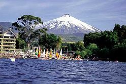
The Lake District is characterized by piedmont lakes crowned by snowcapped volcanoes, whose lower flanks are covered with lush forests of native trees. Lovely towns and villages dot the lakesides, chiefly Pucón
Pucón
Pucón is a Chilean city and commune administered by the municipality of Pucón located in the Province of Cautín, Araucanía Region, 100 km to the southeast of Temuco and 780 km to the south of Santiago....
, Villarrica
Villarrica, Chile
Villarrica is a city and commune in southern Chile located on the western shore of Villarrica Lake in the Province of Cautín, Araucanía Region south of Santiago and close to the Villarrica Volcano ski center to the south east. Residents of Villarrica are known as Villarriquences.Tourism, grain and...
, Frutillar
Frutillar
Frutillar is a city and commune located in southern Chile in the Los Lagos Region. The bay of Frutillar is placed on the banks of Lake Llanquihue, the largest lake entirely within Chile.-History:...
and Puerto Varas
Puerto Varas
Puerto Varas is a city and commune located in the southern Chilean province of Llanquihue, in the Los Lagos Region.The city is well known for its German traditions, its food, its fish and seafood, the natural environment, its casino and 5 star hotels. Only from Puerto Montt, located on the shore...
. Puerto Montt
Puerto Montt
Puerto Montt is a port city and commune in southern Chile, located at the northern end of the Reloncaví Sound in the Llanquihue Province, Los Lagos Region. The commune spans an area of and had a population of 175,938 in 2002. It is located 1,055 km to the south of the capital, Santiago...
is the tourist hub of the region.
The most visited national parks include Puyehue National Park
Puyehue National Park
Puyehue National Park is located in the Andes, in Los Ríos and Los Lagos Region of Chile. It covers . The Route 215 passes through the park. It connects with the Argentine Route 231 via Cardenal Antonio Samoré Pass....
and Vicente Pérez Rosales National Park
Vicente Pérez Rosales National Park
Vicente Pérez Rosales National Park is located in Los Lagos Region, Llanquihue Province, of Chile. Its western entrance is close to the Ensenada locality, northeast of the provincial capital of Puerto Montt, and from Puerto Varas along Ruta CH-225. This national park covers about and is almost...
, the latter is Chile's oldest national park.
Valdivia
Valdivia, Chile
Valdivia is a city and commune in southern Chile administered by the Municipality of Valdivia. The city is named after its founder Pedro de Valdivia and is located at the confluence of the Calle-Calle, Valdivia and Cau-Cau Rivers, approximately east of the coastal towns of Corral and Niebla...
is one of Chile's most beautiful cities, recognition received mainly because of its lush natural surrounding. South from the city lies the colonial Valdivian Fort System
Valdivian Fort System
The Fort System of Valdivia are a series of Spanish colonial fortifications at Corral Bay, Valdivia and Cruces River established to protect the city of Valdivia, in southern Chile. During the period of Spanish rule , it was one of the biggest systems of fortification in the Americas. It was also a...
.
The almost perfect cone of Osorno Volcano is an iconic landmark in the region. Alike Villarrica Volcano
Villarrica (volcano)
Villarrica is one of Chile's most active volcanoes, rising above the lake and town of the same name. The volcano is also known as Rucapillán, a Mapuche word meaning "House of the Pillán". It is the westernmost of three large stratovolcanoes that trend perpendicular to the Andean chain along the...
, which is one of the few volcanoes in the world that have an active Lava lake
Lava lake
Lava lakes are large volumes of molten lava, usually basaltic, contained in a volcanic vent, crater, or broad depression. The term is used to describe both lava lakes that are wholly or partly molten and those that are solidified...
.
As an added bonus, this zone includes the granite domes of the Cochamó Valley
Cochamó Valley
Cochamó Valley is a U-shaped valley located in the Andes, in Los Lagos Region of Chile, south of the Vicente Pérez Rosales National Park and the east of the Reloncaví Estuary. The valley has a striking similarity to Yosemite Valley. Like Yosemite, rock climbers from around the world come to climb...
.
Zona Austral
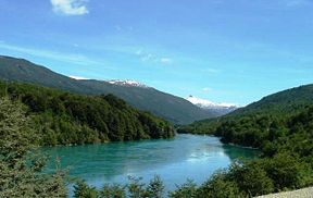
Zona Austral
The Zona Austral is one of the five natural regions into which CORFO divided continental Chile in 1950 corresponding to the Chilean portion of Patagonia. It is surrounded by the Southern Zone and the Chacao Channel to the north, the Pacific Ocean and Drake's Passage to the south and west, and the...
is a premier destination for Ecotourism
Ecotourism
Ecotourism is a form of tourism visiting fragile, pristine, and usually protected areas, intended as a low impact and often small scale alternative to standard commercial tourism...
and Adventure travel. It features countless islands and islets, a maze of steep-sided fjords and channels, large glaciers and icefields and exuberant unspoilt temperate rainforests. Turbulent rivers descend from the Andes, chief of those being the Futaleufú River
Futaleufú River
The Futaleufú River is a river fed by the lakes in the Los Alerces National Park in Chubut Province, Argentina, crossing the Andes Mountains and the international border into Chile and opening into the Yelcho Lake....
, which is widely considered one of the world's most challenging rivers for whitewater kayaking
Whitewater kayaking
Whitewater kayaking is the sport of paddling a kayak on a moving body of water, typically a whitewater river. Whitewater kayaking can range from simple, carefree gently moving water, to demanding, dangerous whitewater. River rapids are graded like ski runs according to the difficulty, danger or...
and rafting
Rafting
Rafting or white water rafting is a challenging recreational outdoor activity using an inflatable raft to navigate a river or other bodies of water. This is usually done on white water or different degrees of rough water, in order to thrill and excite the raft passengers. The development of this...
. Other opportunities for outdoor recreation, include hiking, cycling
Cycling
Cycling, also called bicycling or biking, is the use of bicycles for transport, recreation, or for sport. Persons engaged in cycling are cyclists or bicyclists...
, sea kayaking and flyfishing.
Chiloé is characterized by having a rolling green countryside, but is better known for its peculiar wooden architecture and for its culture, which is full of myths and traditions. Also is remarkable its temperate rainforests.
The scenic Carretera Austral
Carretera Austral
The Carretera Austral , formerly known as Carretera General Augusto Pinochet, is the name given to Chile's Route 7. The highway runs about from Puerto Montt to Villa O'Higgins through rural Patagonia....
crosses or is nearby to many of the most popular destinations in this portion of Chile. Those include Pumalín Park
Pumalín Park
Pumalín Park is a private nature reserve in the Palena Province of Chile, created by the United States environmental foundation The Conservation Land Trust, which is endowed and led by the American business magnate Douglas Tompkins...
, Yelcho Lake
Yelcho Lake
Yelcho Lake is a fjord-shaped lake located in the southern Los Lagos Region, in the Palena Province, Chile. Its outlet is a river of the same name, which flows north-west and empties into Gulf of Corcovado, near Chaitén. The lake is fed by the Futaleufú River. The Carretera Austral runs along its...
, Queulat National Park
Queulat National Park
Queulat National Park is a national park of Chile located in the Aisén Region. The park is bordered by the Cisnes River on the south side and is neighbor to Lago Rosselot National Reserve...
, Cerro Castillo National Reserve
Cerro Castillo National Reserve
Cerro Castillo National Reserve is a nature reserve of Chile located in the Aisén Region, south of Coyhaique. The reserve is named after Cerro Castillo, its highest mountain and main attraction. The Carretera Austral passes through the reserve....
, General Carrera Lake and Caleta Tortel
Caleta Tortel
Caleta Tortel is a coastal village in Chile. It is the administrave center of the commune of Tortel and is located between the mouth of the Baker River and a small embayment of the Baker Channel. The surrounding geography is rugged, formed by a number of islands, fjords, channels and estuaries...
.
Laguna San Rafael National Park
Laguna San Rafael National Park
Laguna San Rafael National Park is a park located on the Pacific coast of southern Chile. The park is named for the San Rafael Lagoon formed by the retreat of the San Rafael Glacier. Created in 1959, it covers an area of and includes the Northern Patagonian Ice Field...
is the only park where visitors can contemplate at the same time the huge glaciers of Patagonia and the rich diversity of plants of the Valdivian Ecoregion.
Pío XI Glacier, one of the few advancing glaciers in the world, is a must-see in the Chilean Inside Passage.
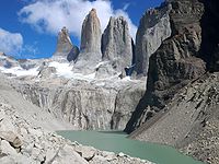
Torres del Paine National Park
Torres del Paine National Park
Torres del Paine National Park is a national park encompassing mountains, a glacier, a lake, and river-rich areas in southern Chilean Patagonia. The Cordillera del Paine is the centerpiece of the park. It lies in a transition area between the Magellanic subpolar forests and the Patagonian Steppes...
is the main attraction in Zona Austral and one of the most beautiful national parks in the world.
The sprawling glaciers of the Cordillera Darwin
Cordillera Darwin
The Cordillera Darwin is an extensive mountain range mantled by an ice field. It is located in the southwestern portion of Isla Grande de Tierra del Fuego, entirely within the Chilean territory. It is part of the longest Andes range and includes the highest mountains in Tierra del Fuego, with...
, which is contained within Alberto de Agostini National Park
Alberto de Agostini National Park
Alberto de Agostini National Park is a park located in the Chilean part of Tierra del Fuego. It covers and includes the Cordillera Darwin mountain range. The park is named after Alberto Maria De Agostini, who was an Italian missionary and explorer. Several tidewater glaciers and steep fjords form...
, are reachable only by boat. Other typical destinations are Puerto Williams
Puerto Williams
Puerto Williams is a Chilean port, located on Isla Navarino facing the Beagle Channel. It is the capital of the Chilean Antarctic Province, one of four provinces located in the Magellan and Chilean Antartica Region...
and Cape Horn
Cape Horn
Cape Horn is the southernmost headland of the Tierra del Fuego archipelago of southern Chile, and is located on the small Hornos Island...
.
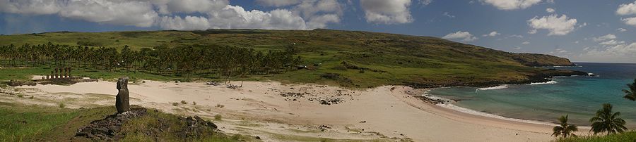
Easter Island
Juan Fernández Islands
.jpg)
Alexander Selkirk
Alexander Selkirk was a Scottish sailor who spent four years as a castaway when he was marooned on an uninhabited island. It is probable that his travels provided the inspiration for Daniel Defoe's novel Robinson Crusoe....
, the man who inspired the Robinson Crusoe
Robinson Crusoe
Robinson Crusoe is a novel by Daniel Defoe that was first published in 1719. Epistolary, confessional, and didactic in form, the book is a fictional autobiography of the title character—a castaway who spends 28 years on a remote tropical island near Trinidad, encountering cannibals, captives, and...
novel. In 1966 the Chilean government renamed Isla Más Afuera to Alejandro Selkirk and Isla Más a Tierra to Robinson Crusoe, in order to promote tourism. Incidentally, Selkirk never set foot on Más Afuera, only on Más a Tierra.
Ethical Traveler Destination
Chile was included in the 2010 and 2011 lists of "The Developing World's 10 Best Ethical Destinations." This is an annual ranking produced by Ethical Traveler magazine, which is based on a study of developing nations from around the world to identify the best tourism destinations among them. The benchmarking uses categories such as environmental protection, social welfare, and human rights.External links
- Last Frontier Ex - Atacama Tourism
- National Tourism Service
- Virtual Tour in 360º of Chile
- Travel: Chile by Rich Grant, International Business Times, May 11, 2009
- Traveling in Chile - this is Chile - Official Chile website
- Tourism in Chile
- City Tours (Santiago - Chile)