

Norte Chico, Chile
Encyclopedia
Natural region
A Natural region is one which is distinguished by its natural features of geography and usually more important, geology. The natural ecology of the region is likely to be significant but one of these factors tends to influence the others....
s on which CORFO
CORFO
Production Development Corporation is a Chilean governmental organization that was founded in 1939, by President Pedro Aguirre Cerda, to promote economic growth in Chile...
divided continental Chile
Chile
Chile ,officially the Republic of Chile , is a country in South America occupying a long, narrow coastal strip between the Andes mountains to the east and the Pacific Ocean to the west. It borders Peru to the north, Bolivia to the northeast, Argentina to the east, and the Drake Passage in the far...
in 1950. Its northern border is formed by the limit with the Far North, on west lies the Pacific Ocean
Pacific Ocean
The Pacific Ocean is the largest of the Earth's oceanic divisions. It extends from the Arctic in the north to the Southern Ocean in the south, bounded by Asia and Australia in the west, and the Americas in the east.At 165.2 million square kilometres in area, this largest division of the World...
, by the east the Andes
Andes
The Andes is the world's longest continental mountain range. It is a continual range of highlands along the western coast of South America. This range is about long, about to wide , and of an average height of about .Along its length, the Andes is split into several ranges, which are separated...
mountains and Argentina
Argentina
Argentina , officially the Argentine Republic , is the second largest country in South America by land area, after Brazil. It is constituted as a federation of 23 provinces and an autonomous city, Buenos Aires...
, and by the south the Zona Central
Zona Central, Chile
Zona central is one of the five natural regions into which CORFO divided continental Chile in 1950. It is home to a majority of the Chilean population and includes the three largest metropolitan areas- Santiago, Valparaíso, and Concepción...
natural region. Although from a strictly geographic point of view, this natural region corresponds to the Chilean territory comprised between the rivers Copiapó
Copiapó River
Copiapó River is a river of Chile located in the Atacama Region. Starting at the confluence of the Jorquera and Pulido rivers, the Copiapó flows for only 2.5 km before receiving the waters of the Manflas River.-References:...
and Aconcagua
Aconcagua River
For other uses, see Aconcagua .The Aconcagua River is a river in Chile that rises from the joint of two minor tributary rivers at above sea level in the Andes, Juncal river from the east and Blanco river from the south east...
, traditionally Norte Chico refers to the zone comprising the regions of Atacama
Atacama Region
The Atacama Region is one of Chile's 15 first order administrative divisions. It comprises three provinces, Chañaral, Copiapó and Huasco. It is bordered to the north by Antofagasta, to the south by Coquimbo, to east with Provinces of Catamarca, La Rioja and San Juan of Argentina, and to west with...
and Coquimbo
Coquimbo Region
The IV Coquimbo Region is one of Chile's 15 first order administrative divisions. It is some 400 km north of the capital, Santiago.The capital and largest city is La Serena, other important cities include the seaport Coquimbo and the agricultural centre...
. This natural region was home to the Diaguita
Diaguita
The Diaguita, also called Diaguita-Calchaquí, are a group of South American indigenous peoples. The Diaguita culture developed between the 8th and 16th centuries in what are now the provinces of Salta, Catamarca, La Rioja and Tucumán in northwestern Argentina, and in the Atacama and Coquimbo...
people.
Geography
The near north (Norte Chico) extends from the southern border of the Atacama DesertAtacama Desert
The Atacama Desert is a plateau in South America, covering a strip of land on the Pacific coast, west of the Andes mountains. It is, according to NASA, National Geographic and many other publications, the driest desert in the world...
to about 32° south latitude, or just north of Santiago
Santiago, Chile
Santiago , also known as Santiago de Chile, is the capital and largest city of Chile, and the center of its largest conurbation . It is located in the country's central valley, at an elevation of above mean sea level...
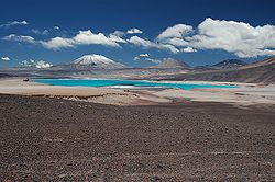
. It is a semiarid region whose central area receives an average of about 25 mm of rain during each of the four winter months, with trace amounts the rest of the year. The near north is also subject to droughts. The temperatures are moderate, with an average of 18.5 °C during the summer and about 12 °C during the winter at sea level. The winter rains and the melting of the snow that accumulates on the Andes produce rivers whose flow varies with the seasons, but which carry water year round. The slopes of the Andes are precipitous, the general surface is rough, and in the north the higher ground and coast are still barren.
As in the far north, the coastal areas of the near north have a distinct microclimate. In those sections where the airborne moisture of the sea is trapped by high bluffs overlooking the ocean, Valdivian temperate rainforest develop as the vegetation precipitates the vapor in the form of a misty rain. Notable examples can be found in the Bosque de Fray Jorge National Park
Bosque de Fray Jorge National Park
Bosque de Fray Jorge national park or Bosque Fray Jorge national park lies in the Limarí Province, Coquimbo Region, Chile. It is a UNESCO Biosphere reserve.- Geography :...
. Because the river valleys provide breaks in the coastal elevations, maritime moisture can penetrate inland and further decrease the generally arid climate in those valleys. The higher elevations in the interior sections are covered with shrubs and cacti of various kinds.
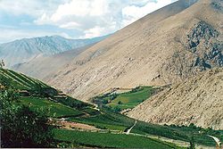
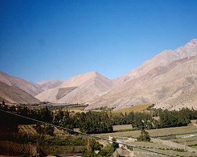
Norte Chico is a highly mountainous district where distinct ranges or elongated spurs cross the country from the Andes to the coast, forming transverse valleys of great beauty and fertility. The most famous of these is the Elqui Valley. The deep transverse valleys provide broad areas for cattle raising and, most important, fruit growing, an activity that has developed greatly since the mid-1970s. Nearly all Chilean pisco
Pisco
Pisco is a colorless or yellowish-to-amber colored grape brandy produced in winemaking regions of Chile and Peru. Pisco was developed by Spanish settlers in the 16th century as an alternative to orujo, a pomace brandy that was being imported from Spain...
is produced in the near north (Chilean laws defines the pisco as a drink produced in the Near North). The cultivation of the soil becomes possible, at first through irrigation
Irrigation
Irrigation may be defined as the science of artificial application of water to the land or soil. It is used to assist in the growing of agricultural crops, maintenance of landscapes, and revegetation of disturbed soils in dry areas and during periods of inadequate rainfall...
and then with the aid of light periodical rains.
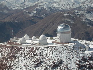
Some areas of Norte Chico feature a very dry air and negligible cloud cover, which make them an excellent location for telescopes. Notable astronomical observatories in the district include Cerro Tololo Inter-American Observatory
Cerro Tololo Inter-American Observatory
The Cerro Tololo Inter-American Observatory is a complex of astronomical telescopes and instruments located at 30.169 S, 70.804 W, approximately 80 km to the East of La Serena, Chile at an altitude of 2200 metres. The complex is part of the National Optical Astronomy Observatory along with Kitt...
and La Silla Observatory
La Silla Observatory
La Silla Observatory is an astronomical observatory in Chile with three telescopes built and operated by the European Southern Observatory organisation, and several others are partly maintained by ESO...
.
The Andes of Norte Chico are home to the first, second and fourth mountain highest in Chile. Corresponding respectively to Ojos del Salado
Ojos del Salado
Nevado Ojos del Salado is a massive stratovolcano in the Andes on the Argentina-Chile border and the highest volcano in the world at . It is also the second highest mountain in the Western Hemisphere and Southern Hemisphere and the highest in Chile...
, Nevado Tres Cruces
Nevado Tres Cruces
Nevado Tres Cruces is a massif of volcanic origin in the Andes Mountains. It has two main summits, Tres Cruces Sur at 6,749 m and Tres Cruces Central at 6,629 m and a third more minor summit, Tres Cruces Norte 6030m. The former marks the border between Argentina and Chile...
and Nevado de Incahuasi
Incahuasi
Incahuasi or Nevado de Incahuasi is a mountain between the Argentine province of Catamarca, and the Atacama Region of Chile. Located at approximate coordinates , it has a height of 6,621m....
.
Rivers
The principal rivers of this natural region are Copiapó, HuascoHuasco River
Huasco River is a river of Chile located in the Huasco Province, Atacama Region. It begins at the confluence of the rivers Del Carmen and Del Tránsito...
, Elqui
Elqui River
The Elqui River starts in the west Andes, flowing into the Pacific Ocean, crossing the Chilean city of La Serena, is a wine and pisco producing area...
, Limarí
Limarí River
Limarí River is a river of Chile located in the Coquimbo Region. The river is formed at the confluence of the Hurtado and Grande rivers, about 4 km east of the city of Ovalle. The lower course of the river borders the southern portion of Bosque de Fray Jorge National Park...
and Choapa
Choapa River
Choapa River or El Río Choapa is a river of Chile located in the Coquimbo Region. The river rises in the Andes, at the confluence of the streams Totoral, Leiva and Del Valle. The river then flows through the town of Salamanca before it meets with its main tributary, the Illapel River...
.
The Copiapó, which once discharged into the sea, is now practically exhausted in irrigating a small fertile valley in which stands the city of that name
Copiapó
Copiapó is a city in northern Chile, located about 40 miles east of the coastal town of Caldera. Founded on December 8, 1744, it is the capital of Copiapó Province and Atacama Region....
. The Copiapó and Huascohave comparatively short courses, but they receive a considerable volume of water from the higher sierras. The latter is also used to irrigate a small, cultivated valley. The rivers of the region of Coquimbo (the Elqui, Limarí and Choapa) exist under less arid conditions, and like those of the northern portion of the Valparaíso Region
Valparaíso Region
The V Valparaíso Region is one of Chile's 15 first order administrative divisions.Valparaíso Region, 2006 With the country's third highest population of 1,539,852 million in 2002 and third smallest area of , the region is Chile's second most densely populated after the Santiago Metropolitan Region...
(namely: Petorca
Petorca River
-References:*...
, La Ligua
La Ligua River
-References:*...
and Aconcagua), are used to irrigate a much larger area of cultivated territory.