

Zona Austral
Encyclopedia
Natural region
A Natural region is one which is distinguished by its natural features of geography and usually more important, geology. The natural ecology of the region is likely to be significant but one of these factors tends to influence the others....
s into which CORFO
CORFO
Production Development Corporation is a Chilean governmental organization that was founded in 1939, by President Pedro Aguirre Cerda, to promote economic growth in Chile...
divided continental Chile
Chile
Chile ,officially the Republic of Chile , is a country in South America occupying a long, narrow coastal strip between the Andes mountains to the east and the Pacific Ocean to the west. It borders Peru to the north, Bolivia to the northeast, Argentina to the east, and the Drake Passage in the far...
in 1950 corresponding to the Chilean portion of Patagonia
Patagonia
Patagonia is a region located in Argentina and Chile, integrating the southernmost section of the Andes mountains to the southwest towards the Pacific ocean and from the east of the cordillera to the valleys it follows south through Colorado River towards Carmen de Patagones in the Atlantic Ocean...
. It is surrounded by the Southern Zone and the Chacao Channel
Chacao Channel
The Chacao Channel is located in Los Lagos Region, Chile and separates Chiloé Island from mainland Chile. The channel was created during the Quaternary glaciations by successive glaciers that flowed down fron the Andes to the coast...
to the north, the Pacific Ocean and Drake's Passage to the south and west, and the Andean mountains and Argentina
Argentina
Argentina , officially the Argentine Republic , is the second largest country in South America by land area, after Brazil. It is constituted as a federation of 23 provinces and an autonomous city, Buenos Aires...
to the east. If excluding Chiloé Archipelago
Chiloé Archipelago
Chiloé Archipelago consists of several islands lying off the coast of Chile. It is separated from mainland Chile by Chacao Channel in the north, the Sea of Chiloé in the east and Gulf of Corcovado to the southeast. All of the archipelago except Desertores Islands, which are part of Palena...
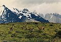
Zona Austral covers all of Chilean Patagonia
Patagonia
Patagonia is a region located in Argentina and Chile, integrating the southernmost section of the Andes mountains to the southwest towards the Pacific ocean and from the east of the cordillera to the valleys it follows south through Colorado River towards Carmen de Patagones in the Atlantic Ocean...
.
Physical geography
In the far south (Chile Austral), which extends from Valdivia through the Chacao Channel to Cape HornCape Horn
Cape Horn is the southernmost headland of the Tierra del Fuego archipelago of southern Chile, and is located on the small Hornos Island...
, the Andes and the South Pacific meet. This district of the country is mountainous, heavily-forested and inhospitable. The deeply-indented coastline is filled with islands which preserve the general outline of the continent southward to the Fuegian archipelago, the outside groups forming a continuation of the Chilean Coast Range
Chilean Coast Range
The Chilean Coastal Range is a mountain range that runs from north to south along the Pacific coast of South America parallel to the Andean Mountains, extending from Morro de Arica in the north to Taitao Peninsula, where it ends at the Chile Triple Junction, in the south. The range has a strong...
. The heavy and continuous rainfall throughout this region, especially in the latitude of Chiloé, gives rise to a large number of rivers and lakes. Farther south this excessive precipitation is in the form of snow in the Andes
Andes
The Andes is the world's longest continental mountain range. It is a continual range of highlands along the western coast of South America. This range is about long, about to wide , and of an average height of about .Along its length, the Andes is split into several ranges, which are separated...
, forming glacier
Glacier
A glacier is a large persistent body of ice that forms where the accumulation of snow exceeds its ablation over many years, often centuries. At least 0.1 km² in area and 50 m thick, but often much larger, a glacier slowly deforms and flows due to stresses induced by its weight...
s at a comparatively low level which in places discharge into the inlets and bays of the sea. The extreme southern part of this region extends eastward to the Atlantic entrance to the Strait of Magellan, and includes the greater part of the Isla Grande de Tierra del Fuego
Isla Grande de Tierra del Fuego
Isla Grande de Tierra del Fuego is an island near the southern tip of South America from which it is separated by the Strait of Magellan...
with all the islands lying south and west of it. There are some comparatively level stretches of country immediately north of the Strait, partly forested and partly grassy plains, where sheep farming has been established with some degree of success, but the greater part of this extreme southern territory is mountainous, cold, wet and inhospitable. The perpetual snow-line here descends to 1,000 to 1,200 m (3,500 to 4,000 ft) above sea-level, and the forest growth does not rise above an altitude of 300 to 450 m (1,000 to 1,500 ft).
Mountains
From the latitude of MichinmahuidaMichinmahuida
Michinmahuida is a glaciated stratovolcano located in Los Lagos Region of Chile. It lies about 15 km east of Chaitén volcano, and was extensively covered in ash during the 2008 eruption of Chaitén...
volcano southwards a well-defined western longitudinal valley, occupied by the Carretera Austral
Carretera Austral
The Carretera Austral , formerly known as Carretera General Augusto Pinochet, is the name given to Chile's Route 7. The highway runs about from Puerto Montt to Villa O'Higgins through rural Patagonia....
, divides the Andes into two chains, the eastern being the main chain, to which belong mounts Ventisquero Sur, Barros Arana and Alto Nevado, while the western chain, broken into imposing blocks, contains several high volcanic peaks such as Corcovado
Corcovado (volcano)
Corcovado Volcano is a stratovolcano located about 25 km south of the mouth of Yelcho River, in the Palena Province, Los Lagos Region, Chile. The glacially eroded volcano is flanked by Holocene cinder cones. The most distinctive feature of this volcano is its stepped top, similar to that of...
, Yanteles
Yanteles
Yanteles is an isolated stratovolcano composed of five glacier-capped peaks along an 8 km-long NE-trending ridge. It is located approximately south of the Corcovado volcano in the Chilean X Region within the Corcovado National Park....
and Melimoyu
Melimoyu
Melimoyu is a stratovolcano with an 8-km-wide, largely buried caldera located about 40 km NW of the town of Puerto Puyuhuapi, in the Aisén Region of Chile. It lies near the northern entrance of the Moraleda Channel.- References :*...
.
A important transverse mountain range of the Andes separates the valleys of the rivers Simpson
Simpson River
Simpson River is a river of Chile located in the Aisén Region. The river originates east of the Andes mountains. It forms the western boundary of the city of Coihaique, which is bordered on the north by the Coihaique River, a tributary of the Simpson. In its inferior course, the river flows through...
and Ibañez
Ibáñez River
The Ibáñez River is a river of Chile located in the Aisén Region. It has its origin in the skirts of Hudson volcano and flows south-east through the Andes into the General Carrera Lake. The river borders the south side of Cerro Castillo National Reserve, home to Cerro Castillo....
. This section is dominated by the active Hudson
Mount Hudson
Mount Hudson is a stratovolcano in southern Chile, and the site of one of the largest eruptions in the twentieth century. The mountain itself is covered by a glacier. There is a caldera at the summit from an ancient eruption; modern volcanic activity comes from inside the caldera...
volcano and the jaggy Cerro Castillo
Cerro Castillo
Cerro Castillo is a jagged rocky peak located in the Aisén Region of Chile, within the Cerro Castillo National Reserve. Castillo means castle in Spanish, and the steep basalt walls of the mountain indeed make it look like one. On its sides are a few small glaciers and lakes fed by...
.
Southward from General Carrera lake is found a wide oblique opening in the range, through which flows the river Baker. The main chain of the Andes in the west is an enormous rugged mass of ice and snow of an average height of 2700 m (9000 ft.), sending glaciers to all the western fjords. Monte San Valentin
Monte San Valentin
Monte San Valentin, also known as Monte San Clemente, is the highest mountain in Chilean Patagonia and the highest mountain south of 40°S outside Antarctica. It stands at the north end of the North Patagonian Icefield....
(4,058 m [13,314 ft.]) is the culminating point of the Andes in the region extending from 49°
49th parallel south
The 49th parallel south is a circle of latitude that is 49 degrees south of the Earth's equatorial plane. It crosses the Atlantic Ocean, the Indian Ocean, the Pacific Ocean and South America....
to 46° S
46th parallel south
The 46th parallel south is a circle of latitude that is 46 degrees south of the Earth's equatorial plane. It crosses the Atlantic Ocean, the Indian Ocean, Australasia, the Pacific Ocean and South America....
latitude Monte San Lorenzo
Monte San Lorenzo
Monte San Lorenzo, also known as Monte Cochrane, is a mountain on the border between Argentina and Chile in Patagonia, reaching a height of . The Chilean name of Cochrane comes from the nearby town of Cochrane where climbers often approach the mountain...
, detached from the main chain of the Andes, is 3,706 m (12,156 ft.) high.
The section from 48°
48th parallel south
The 48th parallel south is a circle of latitude that is 48 degrees south of the Earth's equatorial plane. It crosses the Atlantic Ocean, the Indian Ocean, the Pacific Ocean and South America....
to 52° S
52nd parallel south
The 52nd parallel south is a circle of latitude that is 52 degrees south of the Earth's equatorial plane. It crosses the Atlantic Ocean, the Indian Ocean, the Pacific Ocean and South America....
latitude is a continuous ice-capped mountain range, and some of the glaciers extend from the eastern lakes to the western channels, where they reach the sea-level. The highest mountain in the section is Lautaro
Lautaro (volcano)
Lautaro Volcano is an active ice-covered stratovolcano located in Chilean Patagonia, in the northern part of the Southern Patagonian Ice Field. Its summit rises more than above the average surface of the ice cap plateau. It is the tallest mountain in Bernardo O'Higgins National Park and in its...
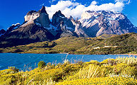
volcano, but the most famous compose the Cordillera del Paine
Cordillera del Paine
The Cordillera del Paine is a small but spectacular mountain group in Torres del Paine National Park in Chilean Patagonia. It is located north of Punta Arenas, and about 1,960 km south of the Chilean capital Santiago. It belongs to the Commune of Torres del Paine in Última Esperanza Province...
in the south and the Fitz Roy group in the north. The southernmost part of this zone is formed by two small parallel ranges called Cordillera Sarmiento
Cordillera Sarmiento
The Cordillera Sarmiento is a mountain rangelocated in the Chilean Patagonia to the west of Puerto Natales. It extends in north-south direction on the western shore of the Fjord of the Mountains and parallel to the Cordillera Riesco. The highest mountain in this range is La Dama Blanca , with an...
and Cordillera Riesco
Cordillera Riesco
The Cordillera Riesco is a mountain rangelocated in the Chilean Patagonia to the west of Puerto Natales. It extends in north-south direction on the eastern shore of the Fjord of the Mountains and parallel to the Cordillera Sarmiento. The rock towers of the "Grupo La Paz" are the centerpiece of this...
, which are separated by the Fjord of the Mountains
Fjord of the Mountains
Fjord of the Mountains, also known as "Channel of the Mountains", is located to the west of Puerto Natales, Chile and inside the boundaries of the Alacalufes National Reserve. It stretches 66 km from north to south and is flanked by two mountain ranges, the Cordillera Sarmiento to the west and the...
.
From the 52 deg. S. lat. up to Strait of Magellan, the western slope of the Cordillera does not, properly speaking, exist. Abrupt walls overlook the Pacific, and great longitudinal and transversal channels and fjords run right through the heart of the range, cutting it generally in a direction more or less oblique to its axis, the result of movements of the Earth's crust. This region is not fully explored, and all that is known of it is that it is principally composed of the same rocks as the Fuegian Andes, and that the greater part of its upper valleys is occupied by glaciers that reach down to the sea amid dense forest.
The Cordillera of the Andes in Tierra del Fuego is formed of crystalline schists, and culminates in the snow-capped peaks of Mount Darwin
Mount Darwin (Andes)
Mount Darwin, the highest peak in Tierra del Fuego at forms part of the Cordillera of the Andes, South America, just to the north of the Beagle Channel. It is formed of crystalline schists and has massive glaciers down its steep southern slopes....
and Monte Sarmiento
Monte Sarmiento
Monte Sarmiento is a pyramidal peak with a glaciated saddle-shaped summit located within Alberto de Agostini National Park, in the Chilean portion of Tierra del Fuego. It rises abruptly from the east shore of the Magdalena Channel and marks the western border of the Cordillera Darwin...
in the Cordillera Darwin
Cordillera Darwin
The Cordillera Darwin is an extensive mountain range mantled by an ice field. It is located in the southwestern portion of Isla Grande de Tierra del Fuego, entirely within the Chilean territory. It is part of the longest Andes range and includes the highest mountains in Tierra del Fuego, with...
, which contains glaciers of greater extent than those of Mont Blanc
Mont Blanc
Mont Blanc or Monte Bianco , meaning "White Mountain", is the highest mountain in the Alps, Western Europe and the European Union. It rises above sea level and is ranked 11th in the world in topographic prominence...
. The extent of the glaciers is considerable in this region, which, geographically, is more complex than was formerly supposed. Although, in the explored portion of the Fuegian chain, the volcanoes which have been mentioned from time to time have not been met with, there seem to have existed to the south, on the islands, many neo-volcanic rocks, some of which appear to be contemporaneous with the basaltic sheet that covers a part of eastern Patagonia.
Farther south the Andes terminates in Cape Horn. In this section the mountains are composed principally of crystalline rocks, and their heights are inconsiderable when compared with those of the northern Andes.
Coasts
The continental coastline features numerous inlets and fjords, from which the mountains seem to rise straight up to great elevations; this is, for example, the case with the Cerro MacáCerro Macá
Cerro Macá is a stratovolcano located to the north of the Aisén Fjord and to the east of the Moraleda Channel, in the Aisén Region of Chile. This glacier-covered volcano lies along the regional Liquiñe-Ofqui Fault Zone....
(2,300 meters) near Puerto Aisén. The rest of the land consists of literally thousands of islands forming numerous archipelagos interwoven with sometimes-narrow channels, which provide the main routes of navigation. The grouping of such islands shows that they are in part the summits of a submerged mountain chain, a continuation southward of the Chilean Coast Range
Chilean Coast Range
The Chilean Coastal Range is a mountain range that runs from north to south along the Pacific coast of South America parallel to the Andean Mountains, extending from Morro de Arica in the north to Taitao Peninsula, where it ends at the Chile Triple Junction, in the south. The range has a strong...
. Three groups of these, called Chiloé
Chiloé Archipelago
Chiloé Archipelago consists of several islands lying off the coast of Chile. It is separated from mainland Chile by Chacao Channel in the north, the Sea of Chiloé in the east and Gulf of Corcovado to the southeast. All of the archipelago except Desertores Islands, which are part of Palena...
, Guaitecas
Guaitecas Archipelago
Guaitecas Archipelago is an archipelago in the municipality of Guaitecas in the Aisén province. The Ciprés de las Guaitecas tree is named after the archipelago. The only settlement in the archipelago is Melinka....
and Chonos
Chonos Archipelago
Chonos Archipelago is a series of low mountainous elongated islands with deep bays, traces of a submerged Chilean Coast Range. Most of the islands are forested with little or no human settlement...
archipelagoes, lie North of the Taitao Peninsula
Taitao Peninsula
The Taitao Peninsula is a westward projection of the mainland of Chile, with which it is connected by the narrow Isthmus of Ofqui, over which the natives and early missionaries were accustomed to carry their boats between the Moraleda Channel and Gulf of Penas...
.
The largest island of this portion of Austral Chile is Chiloé, which is inhabited. Some of the smaller islands of these groups are also inhabited, though the excessive rainfall of these latitudes and the violent westerly storms render them highly unfavourable for human occupation. Some of the smallest islands are barren rocks, but the majority of them are covered with forests. These archipelagoes are separated from the mainland in the north by the gulfs of Ancud
Gulf of Ancud
Gulf of Ancud is a large body of water separating the Chiloé Island from the mainland of Chile. It is located at .-External links:*...
and Corcovado
Gulf of Corcovado
Gulf of Corcovado is a large body of water separating the Chiloé Island from the mainland of Chile. Geologically it is a foreland basin that has been carved out by Quaternary glaciers. A large population of blue whales is found there, and it is under threat from salmon farming....
, 30 to 35 mi wide, which appear to be a submerged part of the great Chilean Central Valley
Chilean Central Valley
The Central Valley , Intermediate Depression or Longitudinal Valley is the depression between the Chilean Costal Range and the Andes Mountains. The central valley should not be confused with Central Chile that encompasses part of the valley...
, and farther south
by the narrower Moraleda Channel
Moraleda Channel
Moraleda Channel is a body of water separating the Chonos Archipelago from the mainland of Chile. It is located at . Southward from the mouth of the Aisén Fjord, Moraleda Channel divides into two arms. The east arm, called Canal Costa , is the main one...
, which terminates southward
in a confusing network of passages between the mainland and the
islands of the Chonos group.
Below the Taitao peninsula is the broad open Gulf of Penas
Gulf of Penas
The Gulf of Penas is a body of water located south of Taitao Peninsula, Chile. It is open to the westerly storms of the Pacific Ocean, but it affords entrance to several natural harbours. Among these are the Gulfs of Tres Montes and San Esteban, and Tarn Bay at the entrance to Messier...
, which carries the coast-line eastward fully 100 mi and is noticeably free from islands, with some exceptions. The northern entrance to Messier Channel
Messier Channel
Messier Channel is a channel located in Patagonia, Chile. It trends north-south between Wellington Island and other Pacific islands and the continent, and is bounded on the north by the Gulf of Penas. This channel is named after Charles Messier, who was a French astronomer. It is a fjord in the...
is through this gulf. Messier, Pitt, Sarmiento
Sarmiento Channel
Sarmiento Channel is a principal Patagonia channel, which extends in a north-south direction. It is the southward continuation of the Angostura Guía and is located in Magallanes y Antártica Chilena Region...
and Smyth's
Smyth Channel
Smyth Channel is a principal Patagonia channel. Its south arm is the southward continuation of the Sarmiento Channel and is located in Magallanes y Antártica Chilena Region...
Channels, which form a comparatively safe and remarkably picturesque inside route for ships, about 338 mi in length, separate another series of archipelagoes from the mainland. These channels are in places narrow and tortuous. Among the islands which thickly fringe this part of the coast, the largest are Merino Jarpa (lying within Baker Channel
Baker Channel
Baker Channel, also known as Calen Inlet, is a channel of Chile located in the Aisén Region. The Baker River discharges into Martinez Inlet, the northern part of this large estuary. It penetrates the mainland about 75 mi and opens into Tarn Bay at the south-east corner of the Gulf of Penas...
), Prat, Campana
Campana Island
Campana Island is an island in the Patagonic Archipelago, Chile. Its area is 1,188 km²....
(part of Guayaneco Archipelago
Guayaneco Archipelago
The Guayaneco Archipelago is an archipelago in southern Chile . It was heavily glaciated during the most recent ice age. These glaciers dissected these mountain islands into a series of deep river valleys and glacial troughs. Today these glacial troughs are deep channels and fjords...
), Little Wellington, Wellington
Wellington Island
Wellington Island is an island west of Southern Patagonian Ice Field, Chile. It has an area of 5,556 km² and most of the island forms part of Bernardo O'Higgins National Park. It is home to the last Kawésqar people, living the village of Puerto Edén, the only inhabited place on the...
and Mornington
Mornington Island (Chile)
Mornington Island is an island in the Patagonian Archipelago in Magallanes y la Antártica Chilena Region, Chile. It has an area of 529 km²....
(of the Wellington Archipelago), Madre de Dios
Madre de Dios Island
Madre de Dios Island is an island in the Patagonian Archipelago in Magallanes y la Antártica Chilena Region, Chile. Its area is 1,043 km². Madre de Dios Island is composed partly by limestone and has several natural caves...
, Duke of York
Duke of York Island (Chile)
Duke of York Island is an island in the Patagonian Archipelago in Magallanes y la Antártica Chilena Region, Chile. It has an area of 522 km²....
, Chatham, Hanover
Hanover Island
Hanover Island is an island in the Patagonian Archipelago in Magallanes y la Antártica Chilena Region, Chile. Its area is 812 km².In popular fiction the island is featured in Jules Verne's book 'Two Years' Vacation'...
, Cambridge, Contreras
Contreras Island
Contreras Island is an island in the Queen Adelaide Archipelago in Magallanes y la Antártica Chilena Region, Chile. Its area is 626 km²....
, Rennell and the Queen Adelaide Archipelago
Queen Adelaide Archipelago
Queen Adelaide Archipelago is an island group in Zona Austral, the extreme south of Chile. It belongs to the Magallanes y la Antártica Chilena Region....
, a group of small barren rocks and islands lying immediately north of the Pacific entrance to the Strait of Magellan
Strait of Magellan
The Strait of Magellan comprises a navigable sea route immediately south of mainland South America and north of Tierra del Fuego...
. The large number of English names on this coast is due to the fact that the earliest detailed survey of this region was made by English naval officers; the charts prepared from their surveys are still in use and form the basis of all subsequent maps.
Belonging to the Tierra del Fuego
Tierra del Fuego
Tierra del Fuego is an archipelago off the southernmost tip of the South American mainland, across the Strait of Magellan. The archipelago consists of a main island Isla Grande de Tierra del Fuego divided between Chile and Argentina with an area of , and a group of smaller islands including Cape...
archipelago south of the Strait of Magellan are Desolación
Desolación Island
Desolación Island is an island at the western end of the Strait of Magellan in the Magallanes y la Antártica Chilena Region, Chile. It belongs to the Tierra del Fuego archipelago...
, Santa Inés, Clarence
Clarence Island, Chile
Clarence Island is an island in the Patagonian Archipelago, Magallanes y la Antártica Chilena Region, Chile. It belongs to the Tierra del Fuego archipelago and to the municipality of Punta Arenas. It is located just south of Brunswick Peninsula and has an area of...
, Capitán Aracena, Dawson
Dawson Island
Dawson Island is an island in the Strait of Magellan that forms part of the Tierra del Fuego archipelago, 100 km south of the city of Punta Arenas in Chile, and part of the Municipality of Punta Arenas. It is located southeast of Brunswick Peninsula and is an approximately 1290 km² tract...
, Londonderry
Londonderry Island
Londonderry is an island in Tierra del Fuego in Chile at the western end of the Beagle Channel and Darwin Sound; the captain of HMS Beagle, Robert FitzRoy, was a descendant of the Marquis of Londonderry. Politically, the island is located in the Commune of Cabo de Hornos, which belongs to the...
, Hoste, Navarino and Wollaston Islands
Wollaston Islands
Wollaston Islands is a group of islands in the extreme south of Chile near Cape Horn. The islands are inside Cabo de Hornos National Park, belonging to the Commune of Cabo de Hornos in Antártica Chilena Province of Magallanes y Antártica Chilena Region....
, with innumerable smaller islands and rocks fringing their shores and filling the channels between them.
The far south contains large expanses of pastures that are best suited for raising sheep, mainly on Isla Grande de Tierra del Fuego
Isla Grande de Tierra del Fuego
Isla Grande de Tierra del Fuego is an island near the southern tip of South America from which it is separated by the Strait of Magellan...
. The area's other main economic activity is oil and natural gas extraction from the areas around the Strait of Magellan. This strait is one of the world's important sea-lanes because it unites the Atlantic and Pacific oceans through a channel that avoids the rough open waters off Cape Horn
Cape Horn
Cape Horn is the southernmost headland of the Tierra del Fuego archipelago of southern Chile, and is located on the small Hornos Island...
. The channel is perilous, however, and Chilean pilots guide all vessels through it.
Rivers
The Comau Fjord and Vodudahue River traverse the densely wooded country in a north-westerly direction from the Andes to the north-eastern shore of the Gulf of Chacao. This area is home to Pumalín ParkPumalín Park
Pumalín Park is a private nature reserve in the Palena Province of Chile, created by the United States environmental foundation The Conservation Land Trust, which is endowed and led by the American business magnate Douglas Tompkins...
. Continuing southward, the Yelcho
Yelcho River
-References:*...
is the next important river to traverse this region. Forming part of its basin is the Futaleufú River
Futaleufú River
The Futaleufú River is a river fed by the lakes in the Los Alerces National Park in Chubut Province, Argentina, crossing the Andes Mountains and the international border into Chile and opening into the Yelcho Lake....
, which drains a large area of Argentine
Argentina
Argentina , officially the Argentine Republic , is the second largest country in South America by land area, after Brazil. It is constituted as a federation of 23 provinces and an autonomous city, Buenos Aires...
territory. Yelcho flows north-west from Yelcho Lake
Yelcho Lake
Yelcho Lake is a fjord-shaped lake located in the southern Los Lagos Region, in the Palena Province, Chile. Its outlet is a river of the same name, which flows north-west and empties into Gulf of Corcovado, near Chaitén. The lake is fed by the Futaleufú River. The Carretera Austral runs along its...
to the Gulf of Corcovado. The Palena
Palena River
The Palena River is a river of Chile. Its sources are close to the border with Argentina and it flows into the Pacific Ocean. It has a length of 6 km.-External links / References:**...
is another river of the same character, having its source in a large frontier lake, which is called General Paz or General Vintter in Argentina and Palena in Chile. It flows for some distance through Argentine territory before crossing into Chile. It receives one large tributary from the south, the Pico River
Pico River
-References:* Rand McNally, The New International Atlas, 1993.*...
, and enters an estuary of the Gulf of Corcovado a little north of the 44th parallel
44th parallel south
The 44th parallel south is a circle of latitude that is 44 degrees south of the Earth's equatorial plane. It crosses the Atlantic Ocean, the Indian Ocean, Australasia, the Pacific Ocean and South America....
.
The Cisnes
Cisnes River
The Cisnes River is a river located in the Aisén Region of the Chilean Patagonia. It runs in east-west direction from the mountains near the border to Argentina and empties into the Pacific Ocean, near the town of Puerto Cisnes at Puyuhuapi Channel.Its characteristic turquoise-blue color is due to...
is wholly a Chilean river, draining an extensive Andean region between the 44th
44th parallel south
The 44th parallel south is a circle of latitude that is 44 degrees south of the Earth's equatorial plane. It crosses the Atlantic Ocean, the Indian Ocean, Australasia, the Pacific Ocean and South America....
and 45th parallels
45th parallel south
The 45th parallel south is a circle of latitude that is 45 degrees south of the Earth's equatorial plane. It is the line that marks the theoretical halfway point between the equator and the South Pole...
and discharging into the Puyuhuapi Channel
Puyuhuapi Channel
thumb|250px|right|View of [[Cay |Cay Volcano]] to the south from Puyuhuapi ChannelPuyuhuapi is a sea channel separating Magdalena Island from the mainland of Aysén Region in Chile. The channel runs through a branch of the Liquiñe-Ofqui Fault. The main settlement in the channel is Puerto Cisnes....
, which separates Magdalena Island
Magdalena Island
Magdalena Island may refer to one of the following islands:In Mexico:*Magdalena Island In Chile:*Magdalena Island, Magallanes Region an island situated in the Strait of Magellan, forming part of The Penguins Natural Monument....
from the mainland. The Aisén River
Aisén River
Aisén River, also spelled Aisén, is a river of Chile located in the Aisén Region. The Aisén begins at the confluence of the Simpson River and the Mañiguales River.Puerto Aisén is located close to its mouth.-References:*...
also has its source near the 46th parallel
46th parallel south
The 46th parallel south is a circle of latitude that is 46 degrees south of the Earth's equatorial plane. It crosses the Atlantic Ocean, the Indian Ocean, Australasia, the Pacific Ocean and South America....
, and drains a mountainous region as far north es the 45th parallel
45th parallel south
The 45th parallel south is a circle of latitude that is 45 degrees south of the Earth's equatorial plane. It is the line that marks the theoretical halfway point between the equator and the South Pole...
, receiving numerous tributaries, and discharging a large volume of water into the Aysén Fjord. The next large river is the Baker River
Baker River (Chile)
The Baker River is a river located in the Aisén Region of the Chilean Patagonia. It is Chile's largest river in terms of volume of water. The river flows out of Bertrand Lake, which is fed by General Carrera Lake. It runs along the east side of the Northern Patagonian Ice Field and empties into the...
, through which the waters of lakes General Carrera
Buenos Aires/General Carrera Lake
The Lake General Carrera or Lake Buenos Aires is a lake located in Patagonia and shared by Argentina and Chile...
and Cochrane, find their way to the Pacific. Both of these large lakes are crossed by the boundary line. The Baker discharges into Baker Channel
Baker Channel
Baker Channel, also known as Calen Inlet, is a channel of Chile located in the Aisén Region. The Baker River discharges into Martinez Inlet, the northern part of this large estuary. It penetrates the mainland about 75 mi and opens into Tarn Bay at the south-east corner of the Gulf of Penas...
. The course of the river from lake General Carrera is south and south-west, the short range of mountains in which are found the cerros San Valentín
Monte San Valentin
Monte San Valentin, also known as Monte San Clemente, is the highest mountain in Chilean Patagonia and the highest mountain south of 40°S outside Antarctica. It stands at the north end of the North Patagonian Icefield....
and Arenales
Cerro Arenales
Cerro Arenales is a heavily ice-covered stratovolcano located in the Aisén Region of Chile, within Laguna San Rafael National Park. It towers over the southern part of the Northern Patagonian Ice Field....
forcing it southward for an outlet. Baker inlet also receives the waters of still another large Argentine-Chilean lake, O'Higgins Lake. Its north-west arm drains into the Pascua River
Pascua River
The Pascua River is a river located in the Aisén Region of Chile. In spite of being a short river, its drainage basin is the seventh-largest in the country due to the great size of the O'Higgins/San Martín Lake, its source....
. After a short north-westerly course the river discharges into Baker Inlet in lat. 48°13' S., long. 73°24' W. South of Pascua river there are no large rivers on this coast, but the narrow fjords penetrate deeply into the mountains and bring away the drainage of their snow-capped, storm-swept elevations. A peculiar network of fjords and connecting channels terminating inland in a peculiarly shaped body of water with long, widely branching arms, called Worsley Sound, Obstruction Sound and Última Esperanza Sound
Última Esperanza Sound
Última Esperanza Sound is an inlet stretching from the mouth of Eberhard Fjord to the outskirts of Monte Balmaceda, within the Magallanes Basin. This inlet, known within Chile as Seno Última Esperanza, has the characteristics of a tidewater river and drains an extensive basin...
, covers an extensive area between the 51st
51st parallel south
The 51st parallel south is a circle of latitude that is 51 degrees south of the Earth's equatorial plane. It crosses the Atlantic Ocean, the Indian Ocean, the Pacific Ocean and South America....
and 53rd parallels
53rd parallel south
The 53rd parallel south is a circle of latitude that is 53 degrees south of the Earth's equatorial plane. It crosses the Atlantic Ocean, the Indian Ocean, the Pacific Ocean and South America....
, and extends nearly to the Argentine frontier.
It has the characteristics of a tidewater river and drains an extensive region.
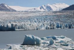
A noteworthy peculiarity of southern Chile, from the Taitao peninsula to Tierra del Fuego, is the large number of glaciers formed on the western and southern slopes of the Andes and other high elevations, which discharge direct into these deeply cut estuaries. Some of the larger lakes of the Andes have glaciers discharging into them. The formation of these icy streams at comparatively low levels, with their discharge direct into tidewater estuaries, is a phenomenon not to be found elsewhere in the same latitudes.
Lakes
The great Andean lakes of Palena (near the 44th parallel44th parallel south
The 44th parallel south is a circle of latitude that is 44 degrees south of the Earth's equatorial plane. It crosses the Atlantic Ocean, the Indian Ocean, Australasia, the Pacific Ocean and South America....
), General Carrera (in lat 46°30' S.), Cochrane (47° 15' S.) and O'Higgins (49° S.
49th parallel south
The 49th parallel south is a circle of latitude that is 49 degrees south of the Earth's equatorial plane. It crosses the Atlantic Ocean, the Indian Ocean, the Pacific Ocean and South America....
), lie partly within Chilean territory. In Argentina are called, respectively, General Paz (also is known as General Vintter), Buenos Aires, Pueyrredón and San Martín. Towards the coast, other important lakes are Presidente Rios Lake
Presidente Ríos Lake
Presidente Ríos Lake is located in the Aisén Region of Chile. It lies in the middle of the Taitao Peninsula....
, Laguna San Rafael and Yulton Lake
Yulton Lake
Yulton Lake, situated 4 km west of Cay Volcano and 15 k mwest of Maca Volcano, is a volcano-dammed lake in Aysén Region, Chile....
.
Southward from the southern portion of Southern Patagonian Ice Field
Southern Patagonian Ice Field
The Southern Patagonian Ice Field , located at the Southern Patagonic Andes between Argentina and Chile, is the second largest contiguous extrapolar extent of ice in the world...
(about 51° S.
51st parallel south
The 51st parallel south is a circle of latitude that is 51 degrees south of the Earth's equatorial plane. It crosses the Atlantic Ocean, the Indian Ocean, the Pacific Ocean and South America....
lat.), lakes include Del Toro
Del Toro Lake
Del Toro Lake is a lake located in the Magallanes Region, southern Chile. Also known as Lago del Toro or Lago Toro, its etymology comes from the lake's ability to generate 4 m swells due to a long fetch and high winds aligned with the long axis of the lake...
and Sarmiento
Sarmiento Lake
Sarmiento Lake is a lake located in Torres del Paine National Park, in the Magallanes Region of southern Chile. The lake is named after Pedro Sarmiento de Gamboa who was a Spanish explorer. This lake also names one of the different areas in the National Park Torres del Paine. The lake literally...
. The former overflows into Última Esperanza Sound.
In the extreme south of Chile mainland is Laguna Blanca, a large fresh-water lake in lat. 52° 30' S.,
Notable lakes in Tierra del Fuego include Fagnano
Fagnano Lake
Cami Lake is a lake located on the main island of the Tierra del Fuego archipelago, and shared by Argentina and Chile....
(shared with Argentina), Blanco and Ofhidro.
Climate
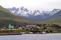
In the northern part of the far south, there is still plenty of rainfall. For instance, Puerto Aisén, at 45°24' south latitude, receives 2,973.3 millimeters of rain per year. However, unlike in Valdivia, the rain falls more or less evenly throughout the year in Puerto Aisén. The summer months average 206.1 millimeters, whereas the winter months average 300 millimeters. The temperatures at sea level in Puerto Aisén average 13.6 °C in the summer months and 4.7 °C in the winter months. Although the area generally is chilly and wet, the combination of channels, fjords, snowcapped mountains, and islands of all shapes and sizes within such a narrow space makes for breathtaking views. The area is still heavily forested, although some of the native species of trees that grow in the central and southern parts of the country have given way to others better adapted to a generally colder climate.The southern part of the far south includes the city of Punta Arenas
Punta Arenas, Chile
Punta Arenas is a commune and the capital city of Chile's southernmost region, Magallanes and Antartica Chilena. The city was officially renamed Magallanes in 1927, but in 1938 it was changed back to Punta Arenas...
, which, with about 125,000 inhabitants, is the southernmost city of any appreciable size in the world. It receives much less precipitation; its annual total is only 438.5 millimeters, or a little more than what Valdivia receives in the month of June alone. This precipitation is distributed more or less evenly throughout the year, with the two main summer months receiving a monthly average of thirty-one millimeters and the winter months 38.9 millimeters, some of it in the form of snow. Temperatures are colder than in the rest of the country. The summer months average 11.1 °C, and the winter months average 2.5 °C. The virtually constant wind from the South Pacific Ocean makes the air feel much colder.