

Norte Grande, Chile
Encyclopedia

Natural region
A Natural region is one which is distinguished by its natural features of geography and usually more important, geology. The natural ecology of the region is likely to be significant but one of these factors tends to influence the others....
s into which CORFO
CORFO
Production Development Corporation is a Chilean governmental organization that was founded in 1939, by President Pedro Aguirre Cerda, to promote economic growth in Chile...
divided continental Chile
Chile
Chile ,officially the Republic of Chile , is a country in South America occupying a long, narrow coastal strip between the Andes mountains to the east and the Pacific Ocean to the west. It borders Peru to the north, Bolivia to the northeast, Argentina to the east, and the Drake Passage in the far...
in 1950. It borders Peru
Peru
Peru , officially the Republic of Peru , is a country in western South America. It is bordered on the north by Ecuador and Colombia, on the east by Brazil, on the southeast by Bolivia, on the south by Chile, and on the west by the Pacific Ocean....
to the north, the Pacific Ocean
Pacific Ocean
The Pacific Ocean is the largest of the Earth's oceanic divisions. It extends from the Arctic in the north to the Southern Ocean in the south, bounded by Asia and Australia in the west, and the Americas in the east.At 165.2 million square kilometres in area, this largest division of the World...
to the west, the Altiplano
Altiplano
The Altiplano , in west-central South America, where the Andes are at their widest, is the most extensive area of high plateau on Earth outside of Tibet...
, Bolivia
Bolivia
Bolivia officially known as Plurinational State of Bolivia , is a landlocked country in central South America. It is the poorest country in South America...
and Argentina
Argentina
Argentina , officially the Argentine Republic , is the second largest country in South America by land area, after Brazil. It is constituted as a federation of 23 provinces and an autonomous city, Buenos Aires...
to the east, and the Copiapó River
Copiapó River
Copiapó River is a river of Chile located in the Atacama Region. Starting at the confluence of the Jorquera and Pulido rivers, the Copiapó flows for only 2.5 km before receiving the waters of the Manflas River.-References:...
to the south, beyond which lies the Norte Chico
Norte Chico, Chile
The Norte Chico is one of the five natural regions on which CORFO divided continental Chile in 1950. Its northern border is formed by the limit with the Far North, on west lies the Pacific Ocean, by the east the Andes mountains and Argentina, and by the south the Zona Central natural region...
natural region.
Geography
The Norte Grande, which extends from the PeruPeru
Peru , officially the Republic of Peru , is a country in western South America. It is bordered on the north by Ecuador and Colombia, on the east by Brazil, on the southeast by Bolivia, on the south by Chile, and on the west by the Pacific Ocean....
vian border to about 27° south latitude, a line roughly paralleled by the Copiapó river, is extremely arid
Arid
A region is said to be arid when it is characterized by a severe lack of available water, to the extent of hindering or even preventing the growth and development of plant and animal life...
. It contains the Atacama Desert
Atacama Desert
The Atacama Desert is a plateau in South America, covering a strip of land on the Pacific coast, west of the Andes mountains. It is, according to NASA, National Geographic and many other publications, the driest desert in the world...
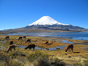
, one of the driest areas in the world; in certain sections, this desert does not register any rainfall at all. Average monthly temperatures range at sea level between about 20.5 °C during the summer and about 14 °C during the winter. Most of the population lives in the coastal area, where the temperatures are more moderate and the humidity higher.
The desert region is an elevated arid plateau descending gradually from the Andes
Andes
The Andes is the world's longest continental mountain range. It is a continual range of highlands along the western coast of South America. This range is about long, about to wide , and of an average height of about .Along its length, the Andes is split into several ranges, which are separated...
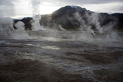
towards the coast, where it breaks down abruptly from elevations of 800 to 1500 ft. From the sea this plateau escarpment has the appearance of a range of flat topped hills closely following the coast line. This topography generates coastal microclimates because the fog that frequently forms over the cold ocean waters, as well as any low clouds, is trapped by the high bluffs. This airborne moisture condenses in the spines and leaves of the vegetation, droplets that fall to the ground and irrigate the plants' roots. The fog of this area is known locally as Camanchaca.
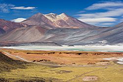
Beyond the coastal bluffs, there is an area of rolling hills that encompasses the driest desert land; this area ends to the east with the Andes towering over it. This region is rainless, barren and inhospitable, absolutely destitute of vegetation except in some small river valleys where irrigation is possible, and on the slopes of some of the snow-covered peaks where the water from the melting snows nourishes a scanty and coarse vegetation before it disappears in the thirsty sands. It is very rich in mineral and saline deposits, however. This area is broken by ranges of barren hills having the appearance of spurs from the Andes, and by irregular lateral ranges in the vicinity of the main cordillera enclosing elevated saline plateaus. Within the mountain ranges parallel to the main chain of the Andes, the main one is the Cordillera Domeyko
Cordillera Domeyko
The Cordillera Domeyko is a mountain range of the Andes located in northern Chile, west of Salar de Atacama. It runs north-south for approximately 600 km, parallel to the main chain...
and among the salt flats the greater is the Salar de Atacama
Salar de Atacama
Salar de Atacama is the largest salt flat in Chile. It is located south of San Pedro de Atacama, is surrounded by mountains and has no drainage outlets. To the east is enclosed by the main chain of the Andes, while to the west lies a secondary mountain range of the Andes called Cordillera de Domeyko...
.
The edges of the desert in some sections have subterranean aquifers that have permitted the development of forests made up mainly of tamarugos, spiny trees native to the area that grow to a height of about twenty-five meters. Most of those forests were cut down to fuel the fires of the many foundries established since colonial times to exploit the abundant deposits of copper, silver, and nitrate found in the area. The result was the creation of even drier surface conditions.
The eastern parts of this region lie within the higher ranges of the Andes and include a large district. This arid, bleak area is apparently a continuation southward of the great Altiplano
Altiplano
The Altiplano , in west-central South America, where the Andes are at their widest, is the most extensive area of high plateau on Earth outside of Tibet...
, and is known as the Puna de Atacama
Puna de Atacama
The Puna de Atacama or Atacama Plateau is an arid high plateau averaging about above sea level and spanning an area of , in the Andes of northern Chile and Argentina and southwest Bolivia. Before the War of the Pacific , the region belonged to Bolivia. In 1898 it was ceded to Argentina in...
. Its average elevation is estimated at 11,000 to 12,000 ft. A line of volcanoes crosses it from north to south, and extensive lava beds cover a considerable part of its surface. The chief summits being those of Licancabur
Licancabur
Licancabur is a highly symmetrical stratovolcano on the southernmost part of the border between Chile and Bolivia. It is located just southwest of Laguna Verde in Bolivia. The volcano dominates the landscape of the Salar de Atacama area...
, Acamarachi
Acamarachi
Acamarachi, also known as Pili, is a stratovolcano located northeast of the volcanoes Aguas Calientes and Lascar, and southwest of the sector Salar de Pujsa of Los Flamencos National Reserve, in the Antofagasta Region of Chile. The volcano lies on a high plateau called Puna de Atacama.It has a...
, Láscar, Miñiques
Miñiques
Miñiques is a massive volcanic complex containing a large number of craters, lava domes and flows, located in the Antofagasta Region of Chile. Located south of Volcán Chiliques and west of Cordón Puntas Negras, it is part of a frequently visited attraction conformed by the high plain lagoons...
, Pular
Pular (volcano)
Pular is a massive stratovolcano located in the Antofagasta Region of northern Chile, about 15 km west of the border with Argentina, which in this area is a straight line between the summits of Socompa volcano and Cerro del Rincón...
, Socompa
Socompa
Socompa is a large complex stratovolcano at the border of Argentina and Chile. It is best known for its large debris avalanche deposit, which is widely accepted as the best-preserved example of this type of deposit in the world, and also notable as the home of the world's most elevated known...
, Llullaillaco
Llullaillaco
Llullaillaco is a stratovolcano at the border of Argentina and Chile. It lies in the Puna de Atacama, a region of very high volcanic peaks on a high plateau within the Atacama Desert, one of the driest places in the world...
. Large shallow saline lakes are also characteristic features of this region. The area receives considerable rainfall during the summer months in what is commonly known as the Bolivian Winter, forming shallow lakes of mostly saline waters that are home to a number of bird species, including the flamingo species Andean
Andean Flamingo
The Andean flamingo, or Phoenicopterus andinus, is one of the rarest flamingos in the world. It has a pale pink body with brighter upperparts, deep vinaceous-pink lower neck, breast, and wing-coverts. It is the only flamingo species with yellow legs and three-toed feet. The bill of the Andean...
, Chilean
Chilean Flamingo
The Chilean Flamingo is a large species closely related to Caribbean Flamingo and Greater Flamingo, with which it was sometimes considered conspecific...
and James
James's Flamingo
James's Flamingo is also known as the Puna Flamingo. Named for Harry Berkeley James, it populates the high altitudes of Andean plateaus of Peru, Chile, Bolivia and Argentina. It is closely related to the Andean Flamingo, and the two make up the genus Phoenicoparrus...
.
Contrary to the image of monochrome barrenness that most people associate with deserts, the landscape is spectacular, with its crisscrossing hills and mountains of all shapes and sizes, each with a unique color and hue depending on its mineral composition, its distance from the observer, and the time of day.
Northward from the Atacama desert core area, some of the water from the altiplano trickles down the Andes in the form of narrow rivers, many of which form oases before being lost to evaporation or absorption into the desert sands, salt beds, and aquifers. However, some rivers do manage to reach into the Pacific, including the Loa River
Loa River
The Loa River is a U-shaped river in Chile's northern Antofagasta Region. At 440 km long it is the country's longest river and the main watercourse in the Atacama Desert.-Course:...
, whose U-shaped course across the desert makes it Chile's longest river. The water rights for one of the rivers, the Lauca River
Lauca River
The Lauca River is a binational river. It originates from Chilean Altiplano of the Tarapacá Region, crosses the Andes and empties into Coipasa Lake, in Bolivia....
, remain a source of dispute between Bolivia
Bolivia
Bolivia officially known as Plurinational State of Bolivia , is a landlocked country in central South America. It is the poorest country in South America...
and Chile. These narrow rivers have carved fertile valleys in which an exuberant vegetation creates a stark contrast to the bone-dry hills. In such areas, known locally as Quebradas, roads usually are built half way up the arid elevations in order to maximize the intensive agricultural use of the irrigated land. They offer spectacular panoramic vistas, along with the harrowing experience of driving along the edges of cliffs. The Quebradas separate extensive plains called Pampas. The major of those is the Pampa del Tamarugal
Pampa del Tamarugal
Pampa del Tamarugal is a vast plain encompassing a significant portion of the Norte Grande, Chile, and originally named for the Prosopis tamarugo trees that used to cover its surface. It is located between the parallels 19°30’ and 22°15’ south latitude and is considered part of the Atacama Desert...
.
In the Norte Grande, the kinds of fruits that grow well in the arid tropics thrive, and all kinds of vegetables can be grown year-round, noticeably in Azapa Valley
Azapa Valley
Azapa Valley in Chile is a fertile and narrow oasis, framed between two sere hills and divided by the summer season-running "San Jose" river . It is located three kilometers from Arica...
. However, the region's main economic foundation is its great mineral wealth. For instance, Chuquicamata
Chuquicamata
Chuquicamata, or "Chuqui" as it is more familiarly known, is by digged volume the biggest open pit copper mine in the world, located in the north of Chile, 215 km northeast of Antofagasta and 1,240 km north of the capital, Santiago...
and Escondida
Escondida
Minera Escondida, which means 'hidden' in Spanish, is a mining company that operates two open pit copper mines in the Atacama Desert, 170 km southeast of Antofagasta in northern Chile. It is currently the highest producing copper mine in the world...
. The former is the world's largest open-pit copper mine and the latter is the copper open-pit mine with the largest production in the world. Since the early 1970s, the fishing industry has also developed enormously in the main ports of the area, most notably Arica
Arica, Chile
Arica is a commune and a port city with a population of 185,269 in the Arica Province of northern Chile's Arica and Parinacota Region, located only south of the border with Peru. The city is the capital of both the Arica Province and the Arica and Parinacota Region...
, Iquique and Antofagasta.