
Malvern Hills
Encyclopedia
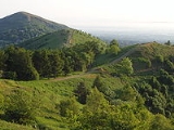
The Malvern Hills are a range of hills in the English counties of Worcestershire
, Herefordshire
and a small area of northern Gloucestershire
, dominating the surrounding countryside and the towns and villages of the district of Malvern
. The highest summit of the hills affords a panorama of the Severn valley
with the hills of Herefordshire and the Welsh mountains, parts of thirteen counties, the Bristol Channel
, and the cathedrals of Worcester, Gloucester and Hereford.
They are known for their spring water - initially made famous by the region's many holy wells, and later through the development of the 19th century spa town
of Great Malvern
, a process which culminated in the production of the modern bottled drinking water.
The Malvern Hills have been designated by the Countryside Agency
as an Area of Outstanding Natural Beauty
.
Management of the hills is the responsibility of the Malvern Hills Conservators
.
moelfryn (bald hill). It has been known as Malferna (11th century), Malverne (12th century), and Much Malvern (16–17th century).
Jabez Allies
, a 19th Century antiquarian
from Worcestershire speculated that 'vern' was derived from the British words 'Sarn' or 'Varn' meaning pavement or seat of judgement.
and the village of Colwall
, and overlook the River Severn
valley to the east, with the Cotswolds
beyond. The highest point of the hills is the Worcestershire Beacon
at 425 metres (1,394 ft) above sea level
(OS Grid reference SO768452). The hills are famous for their natural mineral springs and wells, which were responsible for the development of Great Malvern
as a spa
in the early 19th century. Until recently, Malvern water
was bottled commercially on a large scale and sold worldwide.
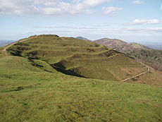
There are three passes over the hills, the Wyche cutting, the A438 road north of Raggedstone Hill
and the A449 road
just north of the Herefordshire Beacon
, the site of the British Camp
, an Iron Age
hill fort
at the top of the hill. The site is thought to date back before the Common Era
and has been extended subsequently by a medieval castle
. The extensive earthworks
remain clearly visible today and determine the shape of the hill.
s from the late pre-Cambrian, around 680 million years old.
The Malvern Line
or Malvern Lineament is the name applied to a north-south aligned lineament
which runs through the Malvern Hills and extends southwards towards Bristol
and northwards past Kidderminster
. It consists of a series of faults and folds
which have the effect of bringing old Malvernian rocks to the surface. Being largely hard igneous rocks, they have resisted erosion
better than those of the surrounding countryside and result in a striking line of hills of which the Malvern Hills are the most impressive. This line is considered to mark the edge of two terrane
s – two once separate fragments of the Earth's crust now joined as one – the Wrekin Terrane to the west and the Charnwood Terrane to the east.
The main face of Gullet Quarry shows a cross-section through the Pre-Cambrian rock and exhibits many rock types including diorite
, granite
, gneiss
, schist
, pegmatite
and dolerite. The evidence of the complex history of earth movement which formed the Hills can be seen by multiple joints, fractures, faults and shears, which make identifying changes in rock types difficult. Mineral deposits such as haematite, calcite
and epidote
can be seen within these features.
There is a tiny cave near the ridge of the hills called Clutter's Cave (or Giant's Cave or Waum's Cave, after the spring which once lay beneath it). The man made cave has been excavated into pillow lavas. Some of the rounded ‘pillow’ shapes are still visible around the entrance to the cave.
 The quality of Malvern water is attributable to its source. Malvern Hills are amongst the oldest and hardest rocks found in the United Kingdom, with their geology responsible for the quality of Malvern's spring water. The hills consist of Precambrian
igneous and metamorphic rock
, the oldest of which are about 670 million years old. The rocks are characterised by low porosity and high secondary permeability via fissures. Malvern water is rainwater and snow meltwater that percolates through fissures created by the pressures of tectonic movements about 300 million years ago when advancing sedimentary layers of Silurian
shale
and limestone
were pushed into and under older Precambrian rock. When the fissures are saturated, a water table
forms and the water emerges as springs around the fault lines between the strata. Depending on rainfall, the flow can vary from as little as 36 litres (76.1 US pt) per minute to over 350 litres (739.7 US pt) per minute. The water permeates through the rock which, because of its hardness, leaves little or no mineral traces in the water, while at the same time the very fine cracks act as a filter for other impurities. Rainfall on the Malvern Hills is thought to be sufficient to account for all the water that runs out of the springs, reflected for example in some spring flows six to eight weeks after heavy rainfall, and in reduced flows after a dry period.
(AONB) in 1959. The designation covers 105 square kilometres (41 sq mi) and includes parts of Herefordshire, Worcestershire and Gloucestershire. The Malvern Hills Conservators played a key role in ensuring that the area of the AONB is larger than that originally proposed.
The AONB Partnership work together to conserve and enhance the Malvern Hills AONB. The Partnership has a formal structure including representatives from private and public enterprises, officers from local authorities, the Countryside Agency
and the Malvern Hills Conservators.
The Malvern Hills Conservators manage most parts of the Hills and the surrounding Commons, some other parcels of land and many roadside verges according to the Malvern Hills Acts 1884 to 1995. The total area under their jurisdiction is over 1200 hectares (2,965.3 acre).
was launched in 2004. It falls within the counties of Herefordshire, Gloucestershire, Shropshire
and Worcestershire and covers 1250 square mile. The geological and geomorphological significance of the area has been recognised for many years with 13 Sites of Special Scientific Interest (SSSI) and 179 Local Geological Sites (LGS) present. The Abberley and Malvern Hills Geopark is one of only seven geoparks in the UK.
 A list of the hills in their order from north to south is shown below:
A good panorama
of the length of the hills can be seen from the M5 Motorway
, particularly between Junction 7 Worcester
(south) and Junction 9 Tewkesbury
. See http://www.malvern-hills.co.uk/panorama.html.
 Flint axes, arrowheads, and flakes found in the area are attributed to early Bronze Age
settlers, and the 'Shire Ditch', a late Bronze Age boundary earthwork possibly dating from around 1000 BC, was constructed along part of the crest of the hills near the site of later settlements. The Wyche Cutting, a mountain pass through the hills was in use in prehistoric times as part of the salt route from Droitwich
to South Wales. A 19th century discovery of over two hundred metal money bars suggests that the area had been inhabited by the La Tène people
around 250 BC. Ancient folklore has it that the British
chieftain Caractacus made his last stand against the Romans
at the British Camp
, a site of extensive Iron Age earthworks on a summit of the Malvern Hills close to where Malvern was to be later established. The story remains disputed, however, as Roman historian Tacitus
implies a site closer to the river Severn. There is therefore no evidence that Roman presence ended the prehistoric settlement at British Camp. However, excavations at nearby Midsummer Hill
fort, Bredon Hill
and Croft Ambrey
all show evidence of violent destruction around the year 48 AD. This may suggest that the British Camp was abandoned or destroyed around the same time.
In 1884, the Malvern Hills Conservators
were established through an Act of Parliament
to preserve the natural aspect of the hills and protect them from encroachments. However by this time large-scale quarrying had already begun. Quarry works were set in motion in the 1870s at Tank Quarry and at Little Malvern by Pyx Granite Company. The Hills Conservators lobbied parliament to pass an Act limiting the exploitation, and although a second Act was passed in 1924 its provisions were largely ineffective. Quarrying continued until 1966. The landscape itself was irrevocably changed; but there is some debate whether this has enriched or damaged the ecology of the Hills. Certainly the quarrying has changed the Hills forever, including creating habitats for frogs, toads, newts and other small animals. The new cliffs provide nesting sites for certain birds. Some parts are used for personality development for children, especially deprived children, and abseiling and rock climbing courses are offered. The quarries, especially North Quarry and Tank Quarry, have over the years been the sites of several accidents requiring the Emergency Services.
In 1989, the cafe on Worcestershire Beacon burned down. As the Malvern Hills Acts state that no building should be erected on the Conservators' land or on land under their jurisdiction, the Conservators put a bill through Parliament to get the power to build a new one but the House of Lords
opposed it. When the cafe was burned down, the Conservators had plans to replace the building but were advised that they risked prosecution for rebuilding as the original cafe building was an encroachment on common land. The Malvern Hills Bill was in preparation to modernise some of the clauses in previous acts a clause was inserted to gain authority to rebuild the cafe.
Five members of the House of Lords Select Committee visited the Malvern Hills and decided that there were enough facilities in the immediate area and that St Ann's Well cafe should be enough provision on the hills, so the application to rebuild was turned down.
In 2000, a £1.3 million project to reintroduce grazing animals to the Malvern Hills and restore part of its historic network of water spouts was given significant backing of National Lottery
funds. The Malverns Heritage Project aimed to reintroduce grazing animals as a natural means of scrub management and restore several water features. The project was spearheaded by the Malvern Hills AONB Service, in partnership with Worcestershire County Council, Herefordshire Council, Malvern Hills Conservators, Malvern Spa Association, English Nature
, Countryside Agency, National Trust
and English Heritage
. Members of the public were concerned that by erecting temporary fences on the Malvern Hills the Conservators would be straying from their core duty of keeping the Malvern Hills unenclosed as open spaces for the recreation and enjoyment of the public. Although the conservation officer said any enclosures would be small and temporary there were worries that leisure activities that could be affected and that "the feeling of freedom associated with 'just being' on the Malvern Hills" could be lost.
In 2001, the Malvern Hills were officially closed to the public for the first time in history. Walkers were told to avoid the area as part of the effort to prevent the spread of foot and mouth disease. As a result of the closure the economy of the Malvern Hills faced serious damage. In 2002 the Malvern Hills were named the most popular free tourist attraction in the West Midlands in a survey commissioned by the Countryside Agency to take the temperature of rural tourism in the wake of the crisis.
In 2006, Worcestershire County Council was awarded £770,000 by the Heritage Lottery Fund for restoration work and preservation of the area by fitting cattle grids to roads across the Hills and encouraging local landowners to allow sheep to wander across their land. As part of the Malvern Heritage Project nine water features within the AONB were also renovated.
and Ledbury
. The M5 motorway
to the east of Malvern is accessible at junctions 7 and 8. The M50
(also known as the Ross Spur) to the south can be accessed at junction 1 on the A38 road
between Tewkesbury and Malvern.
The AONB has four train stations inside or very close to its boundary – Malvern Link
, Great Malvern
, Colwall
and Ledbury
. These train stations lie on the Cotswolds & Malverns Line
which operates between Oxford
and Hereford
. Direct trains to the area are available from Birmingham
and London
Several local bus services connect Malvern with the surrounding area. Long-distance direct bus services connect Malvern with other cities in the country, including the National Express route 321 through eleven counties from Aberdare in South Wales via Birmingham and other major cities, to Bradford in West Yorkshire, and route 444 from Worcester to London (Victoria).
The Worcestershire Way
is a waymarked long-distance trail
located within the county
of Worcestershire
. It runs 50 kilometres (31.1 mi) from Bewdley
to Great Malvern
. It is an important recreation resource in the AONB.
The Geopark Way
is a 109 miles (175.4 km) long-distance trail which runs from Bridgnorth
to Gloucester
and passes through the Abberley and Malvern Hills Geopark. The route was devised to highlight geology, landscape and associated heritage.
The AONB commissioned study to "identify and assess a selection of key views to and from the Malvern Hills" it was carried out in 2009 by Cooper Partnership Ltd, a firm of Chartered Landscape Architects.
This information was gathered not only so that the best vistas could be made made known to a wider public, but also as an intelligence gathering so that proposed changes to the landscape both in and outside the Malvern Hills area of outstanding beauty (such as the building of wind turbines) could be assessed against the impact those developments would have on the Malvern Hills area of outstanding beauty.
The Cooper Partnership identified 50 key views from vantage points on the Malvern hills, and from the surrounding area. These were:
(1362) by William Langland
, who was possibly educated at the priory of Great Malvern. The earliest poetical allusion to the Malvern Hills occurs in the poem: "And on a Maye mornynge on Malverne hylles".
English composer Edward Elgar
, who was from the area, often walked, cycled, and reportedly flew kites on these hills. He wrote a cantata
in 1898 entitled Caractacus, which alludes to the popular legend of his last stand at British Camp. In 1934, during the composer's final illness, he told a friend: "If ever after I'm dead you hear someone whistling this tune [the opening theme of his cello concerto
] on the Malvern Hills, don't be alarmed. It's only me."
The Malvern Hills feature in Elgar
, a drama documentary made in 1962 by the British director Ken Russell
. Made for BBC Television's long-running Monitor
programme, it dramatised the life of the composer
Edward Elgar. The film significantly raised the public profile of the composer.
Composers Herbert Howells
and Ivor Gurney
used to take long walks together through the nearby Cotswold Hills and the natural beauty of the area, including the magnificent views of the Malverns, was a profound inspiration for their music. Howells dedicated his first major work, the Piano Quartet in A minor (1916), to "the hill at Chosen (Churchdown) and Ivor Gurney who knew it".
In Early British Trackways Alfred Watkins
stated that he believed a ley line
passed along the Malvern Hills through several wells including St Ann's Well, Holy Well
, Walms Well and St. Pewtress Well.
The poet W. H. Auden
taught for three years at The Downs School
, Colwall
, in the Malvern Hills. He spent three years at the school in the 1930s and wrote some of his finest early love poems there, including: This Lunar Beauty; Let Your Sleeping Head; My Love, Fish in the Unruffled Lakes; and Out on the Lawn I Lie in Bed. He also wrote a long poem about the hills and their views, called simply The Malverns.
J.R.R. Tolkien found inspiration in the Malvern landscape. He was introduced to the area by C. S. Lewis
, who had brought him here to meet George Sayer
, the Head of English at Malvern College
. Sayer had been a student of Lewis, and became his biographer, and together with them Tolkien would walk the Malvern Hills. Excerpts from The Hobbit
and The Lord of the Rings
were recorded in Malvern in 1952, at the home of George Sayer. The recordings were later issued on long-playing gramophone record
s. In the liner notes for J.R.R. Tolkien Reads and Sings his The Hobbit & The Fellowship of the Ring, George Sayer wrote that Tolkien would relive the book as they walked and compared parts of the Malvern Hills to the
White Mountains of Gondor
.
The Tank Quarry on North Hill
and West of England Quarry on the Worcestershire Beacon
were used as locations in the Dr Who serial The Krotons
, starring Patrick Troughton
. The serial was broadcast in four weekly parts from December 28, 1968 to January 18, 1969.
The Malvern Hills are the backdrop for Penda's Fen
, a 1974 British television play written by David Rudkin
and directed by Alan Clarke
for the BBC's Play for Today
series. It tells the story of Stephen, a pastor's son who has visions of angels, Edward Elgar, and King Penda, the last pagan ruler of England.
The final scene of the play, where the protagonist has an apparitional experience
of the "mother and father of England", is set on the Malvern Hills.
"Malvern Hills" is the third short story in Japanese-English author Kazuo Ishiguro
's collection Nocturnes
(2009).
Worcestershire
Worcestershire is a non-metropolitan county, established in antiquity, located in the West Midlands region of England. For Eurostat purposes it is a NUTS 3 region and is one of three counties that comprise the "Herefordshire, Worcestershire and Warwickshire" NUTS 2 region...
, Herefordshire
Herefordshire
Herefordshire is a historic and ceremonial county in the West Midlands region of England. For Eurostat purposes it is a NUTS 3 region and is one of three counties that comprise the "Herefordshire, Worcestershire and Gloucestershire" NUTS 2 region. It also forms a unitary district known as the...
and a small area of northern Gloucestershire
Gloucestershire
Gloucestershire is a county in South West England. The county comprises part of the Cotswold Hills, part of the flat fertile valley of the River Severn, and the entire Forest of Dean....
, dominating the surrounding countryside and the towns and villages of the district of Malvern
Malvern, Worcestershire
Malvern is a town and civil parish in Worcestershire, England, governed by Malvern Town Council. As of the 2001 census it has a population of 28,749, and includes the historical settlement and commercial centre of Great Malvern on the steep eastern flank of the Malvern Hills, and the former...
. The highest summit of the hills affords a panorama of the Severn valley
Severn Valley (England)
The Severn Valley is a rural area of mid-western England, through which the River Severn runs and the Severn Valley Railway steam heritage line operates, starting at its northernmost point in Bridgnorth, Shropshire and running south for 16 miles to Bewdley, Worcestershire in the Wyre...
with the hills of Herefordshire and the Welsh mountains, parts of thirteen counties, the Bristol Channel
Bristol Channel
The Bristol Channel is a major inlet in the island of Great Britain, separating South Wales from Devon and Somerset in South West England. It extends from the lower estuary of the River Severn to the North Atlantic Ocean...
, and the cathedrals of Worcester, Gloucester and Hereford.
They are known for their spring water - initially made famous by the region's many holy wells, and later through the development of the 19th century spa town
Spa town
A spa town is a town situated around a mineral spa . Patrons resorted to spas to "take the waters" for their purported health benefits. The word comes from the Belgian town Spa. In continental Europe a spa was known as a ville d'eau...
of Great Malvern
Great Malvern
Great Malvern is an area of Malvern, Worcestershire, England. It is the historical centre of the town, and the location of the headquarters buildings of the of Malvern Town Council, the governing body of the Malvern civil parish, and Malvern Hills District council of the county of...
, a process which culminated in the production of the modern bottled drinking water.
The Malvern Hills have been designated by the Countryside Agency
Countryside Agency
The Countryside Agency in England was a statutory body set up in 1999 with the task of improving the quality of the rural environment and the lives of those living in it. The Agency was formed by merging the Countryside Commission and the Rural Development Commission...
as an Area of Outstanding Natural Beauty
Area of Outstanding Natural Beauty
An Area of Outstanding Natural Beauty is an area of countryside considered to have significant landscape value in England, Wales or Northern Ireland, that has been specially designated by the Countryside Agency on behalf of the United Kingdom government; the Countryside Council for Wales on...
.
Management of the hills is the responsibility of the Malvern Hills Conservators
Malvern Hills Conservators
The Malvern Hills Conservators are a body corporate responsible for the care and management of the Malvern Hills and Commons. They were established in 1884 and are governed by five Acts of Parliament, the Malvern Hills Acts 1884, 1909, 1924, 1930 and 1995. They became a registered charity in...
.
Toponymy
The name Malvern probably comes from the ancient British language meaning 'Bare-Hill', the nearest modern equivalent being the WelshWelsh language
Welsh is a member of the Brythonic branch of the Celtic languages spoken natively in Wales, by some along the Welsh border in England, and in Y Wladfa...
moelfryn (bald hill). It has been known as Malferna (11th century), Malverne (12th century), and Much Malvern (16–17th century).
Jabez Allies
Jabez Allies
-Biography:Allies was one of the earliest writers on folklore. He was the second son of Mr. William Allies, and was born at Lulsley, Worcestershire, 22 October 1787, where his family had resided for generations. In early youth he was deeply impressed by the lingering relics of Roman and Saxon days...
, a 19th Century antiquarian
Antiquarian
An antiquarian or antiquary is an aficionado or student of antiquities or things of the past. More specifically, the term is used for those who study history with particular attention to ancient objects of art or science, archaeological and historic sites, or historic archives and manuscripts...
from Worcestershire speculated that 'vern' was derived from the British words 'Sarn' or 'Varn' meaning pavement or seat of judgement.
Geography
The Malvern Hills are part of an Area of Outstanding Natural Beauty, with scenic views over both Herefordshire and Worcestershire. The Hills run north/south for about 13 kilometres (8 mi), in between Great MalvernGreat Malvern
Great Malvern is an area of Malvern, Worcestershire, England. It is the historical centre of the town, and the location of the headquarters buildings of the of Malvern Town Council, the governing body of the Malvern civil parish, and Malvern Hills District council of the county of...
and the village of Colwall
Colwall
Colwall is a village and civil parish in Herefordshire, England on the border with Worcestershire, nestling into the side of the Malvern Hills. Areas of the village are known as Colwall Stone, Upper Colwall and Colwall Green along over a mile of the B4218 road...
, and overlook the River Severn
River Severn
The River Severn is the longest river in Great Britain, at about , but the second longest on the British Isles, behind the River Shannon. It rises at an altitude of on Plynlimon, Ceredigion near Llanidloes, Powys, in the Cambrian Mountains of mid Wales...
valley to the east, with the Cotswolds
Cotswolds
The Cotswolds are a range of hills in west-central England, sometimes called the Heart of England, an area across and long. The area has been designated as the Cotswold Area of Outstanding Natural Beauty...
beyond. The highest point of the hills is the Worcestershire Beacon
Worcestershire Beacon
Worcestershire Beacon, also popularly known as Worcester Beacon, or locally simply as The Beacon, is a hill whose summit at 425 m is the highest point of the range of Malvern Hills that runs approximately north-south along the Herefordshire-Worcestershire border, although Worcestershire Beacon...
at 425 metres (1,394 ft) above sea level
Sea level
Mean sea level is a measure of the average height of the ocean's surface ; used as a standard in reckoning land elevation...
(OS Grid reference SO768452). The hills are famous for their natural mineral springs and wells, which were responsible for the development of Great Malvern
Great Malvern
Great Malvern is an area of Malvern, Worcestershire, England. It is the historical centre of the town, and the location of the headquarters buildings of the of Malvern Town Council, the governing body of the Malvern civil parish, and Malvern Hills District council of the county of...
as a spa
Spa town
A spa town is a town situated around a mineral spa . Patrons resorted to spas to "take the waters" for their purported health benefits. The word comes from the Belgian town Spa. In continental Europe a spa was known as a ville d'eau...
in the early 19th century. Until recently, Malvern water
Malvern Water
Malvern water is a natural spring water from the Malvern Hills on the border of the counties of Herefordshire and Worcestershire in England. The Hills consist of very hard granite and limestone rock. Fissures in the rock retain rain water, which slowly permeates through, escaping at the springs...
was bottled commercially on a large scale and sold worldwide.
There are three passes over the hills, the Wyche cutting, the A438 road north of Raggedstone Hill
Raggedstone Hill
Raggedstone Hill is situated on the range of Malvern Hills that runs approximately north-south along the Herefordshire-Worcestershire border. Raggedstone Hill lies close to the borders of Herefordshire, Worcestershire and Gloucestershire...
and the A449 road
A449 road
The A449 is a major road in the United Kingdom. It runs north from junction 24 of the M4 motorway at Newport in South Wales to Stafford in Staffordshire....
just north of the Herefordshire Beacon
Herefordshire Beacon
The Herefordshire Beacon is one of the hills of the Malvern Hills.The name Malvern of the nearby town is probably derived from the Welsh moel fryn or "bare hill"....
, the site of the British Camp
British Camp
The British Camp is an Iron Age hill fort located at the top of Herefordshire Beacon in the Malvern Hills. The fort is thought to have been first constructed in the 2nd century BC...
, an Iron Age
Iron Age
The Iron Age is the archaeological period generally occurring after the Bronze Age, marked by the prevalent use of iron. The early period of the age is characterized by the widespread use of iron or steel. The adoption of such material coincided with other changes in society, including differing...
hill fort
Hill fort
A hill fort is a type of earthworks used as a fortified refuge or defended settlement, located to exploit a rise in elevation for defensive advantage. They are typically European and of the Bronze and Iron Ages. Some were used in the post-Roman period...
at the top of the hill. The site is thought to date back before the Common Era
Common Era
Common Era ,abbreviated as CE, is an alternative designation for the calendar era originally introduced by Dionysius Exiguus in the 6th century, traditionally identified with Anno Domini .Dates before the year 1 CE are indicated by the usage of BCE, short for Before the Common Era Common Era...
and has been extended subsequently by a medieval castle
Castle
A castle is a type of fortified structure built in Europe and the Middle East during the Middle Ages by European nobility. Scholars debate the scope of the word castle, but usually consider it to be the private fortified residence of a lord or noble...
. The extensive earthworks
Earthworks (archaeology)
In archaeology, earthwork is a general term to describe artificial changes in land level. Earthworks are often known colloquially as 'lumps and bumps'. Earthworks can themselves be archaeological features or they can show features beneath the surface...
remain clearly visible today and determine the shape of the hill.
Geology
The Malvern Hills are formed of some of the most ancient rocks in England, mostly igneous and metamorphic rockMetamorphic rock
Metamorphic rock is the transformation of an existing rock type, the protolith, in a process called metamorphism, which means "change in form". The protolith is subjected to heat and pressure causing profound physical and/or chemical change...
s from the late pre-Cambrian, around 680 million years old.
The Malvern Line
Malvern Line
The Malvern Line or Malvern Lineament is the name applied to a north-south aligned lineament which runs through the Malvern Hills of western England and extends southwards towards Bristol and northwards past Stourport....
or Malvern Lineament is the name applied to a north-south aligned lineament
Lineament
See also Line A lineament is a linear feature in a landscape which is an expression of an underlying geological structure such as a fault. Typically a lineament will comprise a fault-aligned valley, a series of fault or fold-aligned hills, a straight coastline or indeed a combination of these...
which runs through the Malvern Hills and extends southwards towards Bristol
Bristol
Bristol is a city, unitary authority area and ceremonial county in South West England, with an estimated population of 433,100 for the unitary authority in 2009, and a surrounding Larger Urban Zone with an estimated 1,070,000 residents in 2007...
and northwards past Kidderminster
Kidderminster
Kidderminster is a town, in the Wyre Forest district of Worcestershire, England. It is located approximately seventeen miles south-west of Birmingham city centre and approximately fifteen miles north of Worcester city centre. The 2001 census recorded a population of 55,182 in the town...
. It consists of a series of faults and folds
Fold (geology)
The term fold is used in geology when one or a stack of originally flat and planar surfaces, such as sedimentary strata, are bent or curved as a result of permanent deformation. Synsedimentary folds are those due to slumping of sedimentary material before it is lithified. Folds in rocks vary in...
which have the effect of bringing old Malvernian rocks to the surface. Being largely hard igneous rocks, they have resisted erosion
Erosion
Erosion is when materials are removed from the surface and changed into something else. It only works by hydraulic actions and transport of solids in the natural environment, and leads to the deposition of these materials elsewhere...
better than those of the surrounding countryside and result in a striking line of hills of which the Malvern Hills are the most impressive. This line is considered to mark the edge of two terrane
Terrane
A terrane in geology is short-hand term for a tectonostratigraphic terrane, which is a fragment of crustal material formed on, or broken off from, one tectonic plate and accreted or "sutured" to crust lying on another plate...
s – two once separate fragments of the Earth's crust now joined as one – the Wrekin Terrane to the west and the Charnwood Terrane to the east.
The main face of Gullet Quarry shows a cross-section through the Pre-Cambrian rock and exhibits many rock types including diorite
Diorite
Diorite is a grey to dark grey intermediate intrusive igneous rock composed principally of plagioclase feldspar , biotite, hornblende, and/or pyroxene. It may contain small amounts of quartz, microcline and olivine. Zircon, apatite, sphene, magnetite, ilmenite and sulfides occur as accessory...
, granite
Granite
Granite is a common and widely occurring type of intrusive, felsic, igneous rock. Granite usually has a medium- to coarse-grained texture. Occasionally some individual crystals are larger than the groundmass, in which case the texture is known as porphyritic. A granitic rock with a porphyritic...
, gneiss
Gneiss
Gneiss is a common and widely distributed type of rock formed by high-grade regional metamorphic processes from pre-existing formations that were originally either igneous or sedimentary rocks.-Etymology:...
, schist
Schist
The schists constitute a group of medium-grade metamorphic rocks, chiefly notable for the preponderance of lamellar minerals such as micas, chlorite, talc, hornblende, graphite, and others. Quartz often occurs in drawn-out grains to such an extent that a particular form called quartz schist is...
, pegmatite
Pegmatite
A pegmatite is a very crystalline, intrusive igneous rock composed of interlocking crystals usually larger than 2.5 cm in size; such rocks are referred to as pegmatitic....
and dolerite. The evidence of the complex history of earth movement which formed the Hills can be seen by multiple joints, fractures, faults and shears, which make identifying changes in rock types difficult. Mineral deposits such as haematite, calcite
Calcite
Calcite is a carbonate mineral and the most stable polymorph of calcium carbonate . The other polymorphs are the minerals aragonite and vaterite. Aragonite will change to calcite at 380-470°C, and vaterite is even less stable.-Properties:...
and epidote
Epidote
Epidote is a calcium aluminium iron sorosilicate mineral, Ca2Al2O, crystallizing in the monoclinic system. Well-developed crystals are of frequent occurrence: they are commonly prismatic in habit, the direction of elongation being perpendicular to the single plane of symmetry. The faces are often...
can be seen within these features.
There is a tiny cave near the ridge of the hills called Clutter's Cave (or Giant's Cave or Waum's Cave, after the spring which once lay beneath it). The man made cave has been excavated into pillow lavas. Some of the rounded ‘pillow’ shapes are still visible around the entrance to the cave.
Malvern water
Precambrian
The Precambrian is the name which describes the large span of time in Earth's history before the current Phanerozoic Eon, and is a Supereon divided into several eons of the geologic time scale...
igneous and metamorphic rock
Metamorphic rock
Metamorphic rock is the transformation of an existing rock type, the protolith, in a process called metamorphism, which means "change in form". The protolith is subjected to heat and pressure causing profound physical and/or chemical change...
, the oldest of which are about 670 million years old. The rocks are characterised by low porosity and high secondary permeability via fissures. Malvern water is rainwater and snow meltwater that percolates through fissures created by the pressures of tectonic movements about 300 million years ago when advancing sedimentary layers of Silurian
Silurian
The Silurian is a geologic period and system that extends from the end of the Ordovician Period, about 443.7 ± 1.5 Mya , to the beginning of the Devonian Period, about 416.0 ± 2.8 Mya . As with other geologic periods, the rock beds that define the period's start and end are well identified, but the...
shale
Shale
Shale is a fine-grained, clastic sedimentary rock composed of mud that is a mix of flakes of clay minerals and tiny fragments of other minerals, especially quartz and calcite. The ratio of clay to other minerals is variable. Shale is characterized by breaks along thin laminae or parallel layering...
and limestone
Limestone
Limestone is a sedimentary rock composed largely of the minerals calcite and aragonite, which are different crystal forms of calcium carbonate . Many limestones are composed from skeletal fragments of marine organisms such as coral or foraminifera....
were pushed into and under older Precambrian rock. When the fissures are saturated, a water table
Water table
The water table is the level at which the submarine pressure is far from atmospheric pressure. It may be conveniently visualized as the 'surface' of the subsurface materials that are saturated with groundwater in a given vicinity. However, saturated conditions may extend above the water table as...
forms and the water emerges as springs around the fault lines between the strata. Depending on rainfall, the flow can vary from as little as 36 litres (76.1 US pt) per minute to over 350 litres (739.7 US pt) per minute. The water permeates through the rock which, because of its hardness, leaves little or no mineral traces in the water, while at the same time the very fine cracks act as a filter for other impurities. Rainfall on the Malvern Hills is thought to be sufficient to account for all the water that runs out of the springs, reflected for example in some spring flows six to eight weeks after heavy rainfall, and in reduced flows after a dry period.
Area of Outstanding Natural Beauty
The Malvern Hills were designated an Area of Outstanding Natural BeautyArea of Outstanding Natural Beauty
An Area of Outstanding Natural Beauty is an area of countryside considered to have significant landscape value in England, Wales or Northern Ireland, that has been specially designated by the Countryside Agency on behalf of the United Kingdom government; the Countryside Council for Wales on...
(AONB) in 1959. The designation covers 105 square kilometres (41 sq mi) and includes parts of Herefordshire, Worcestershire and Gloucestershire. The Malvern Hills Conservators played a key role in ensuring that the area of the AONB is larger than that originally proposed.
The AONB Partnership work together to conserve and enhance the Malvern Hills AONB. The Partnership has a formal structure including representatives from private and public enterprises, officers from local authorities, the Countryside Agency
Countryside Agency
The Countryside Agency in England was a statutory body set up in 1999 with the task of improving the quality of the rural environment and the lives of those living in it. The Agency was formed by merging the Countryside Commission and the Rural Development Commission...
and the Malvern Hills Conservators.
The Malvern Hills Conservators manage most parts of the Hills and the surrounding Commons, some other parcels of land and many roadside verges according to the Malvern Hills Acts 1884 to 1995. The total area under their jurisdiction is over 1200 hectares (2,965.3 acre).
Abberley and Malvern Hills Geopark
The Abberley and Malvern Hills GeoparkAbberley and Malvern Hills Geopark
Abberley and Malvern Hills Geopark covers 1250 square kilometres in Gloucestershire, Herefordshire, Shropshire and Worcestershire in England. It was formerly a member of the European Geoparks Network and the UNESCO-assisted Global Geoparks Network though withdrew from both in 2008...
was launched in 2004. It falls within the counties of Herefordshire, Gloucestershire, Shropshire
Shropshire
Shropshire is a county in the West Midlands region of England. For Eurostat purposes, the county is a NUTS 3 region and is one of four counties or unitary districts that comprise the "Shropshire and Staffordshire" NUTS 2 region. It borders Wales to the west...
and Worcestershire and covers 1250 square mile. The geological and geomorphological significance of the area has been recognised for many years with 13 Sites of Special Scientific Interest (SSSI) and 179 Local Geological Sites (LGS) present. The Abberley and Malvern Hills Geopark is one of only seven geoparks in the UK.
The Hills
| Hill | Elevation (ft) | Elevation (m) |
|---|---|---|
| End Hill | 1,079 ft | 329 m |
| Table Hill Table Hill Table Hill is situated in the range of Malvern Hills that runs approximately north-south along the Herefordshire-Worcestershire border. It lies between North Hill and Sugarloaf Hill and has an elevation of .- History :... |
1,224 ft | 373 m |
| North Hill North Hill, Malvern North Hill is the second highest point of the range of Malvern Hills that runs approximately north-south along the Herefordshire-Worcestershire border, although North Hill lies entirely within Worcestershire... |
1,303 ft | 397 m |
| Sugarloaf Hill Sugarloaf Hill, Malvern Sugarloaf Hill lies between the Worcestershire Beacon and North Hill in the range of Malvern Hills that runs approximately north-south along the Herefordshire-Worcestershire border.... |
1,207 ft | 368 m |
| Worcestershire Beacon Worcestershire Beacon Worcestershire Beacon, also popularly known as Worcester Beacon, or locally simply as The Beacon, is a hill whose summit at 425 m is the highest point of the range of Malvern Hills that runs approximately north-south along the Herefordshire-Worcestershire border, although Worcestershire Beacon... |
1,395 ft | 425 m |
| Summer Hill | 1,253 ft | 382 m |
| Perseverance Hill | 1,066 ft | 325 m |
| Jubilee Hill Jubilee Hill Jubilee Hill is situated in the range of Malvern Hills that runs approximately north-south along the Herefordshire-Worcestershire border. It lies between Perseverance Hill and Pinnacle Hill and has an elevation of .... |
1,073 ft | 327 m |
| Pinnacle Hill Pinnacle Hill Pinnacle Hill is situated in the range of Malvern Hills that runs approximately north-south along the Herefordshire-Worcestershire border. It lies between Jubilee Hill and Black Hill and has an elevation of .- External links :*... |
1,174 ft | 358 m |
| Black Hill (north) | 1,011 ft | 308 m |
| Black Hill (south) | 886 ft | 270 m |
| Herefordshire Beacon Herefordshire Beacon The Herefordshire Beacon is one of the hills of the Malvern Hills.The name Malvern of the nearby town is probably derived from the Welsh moel fryn or "bare hill".... (British Camp British Camp The British Camp is an Iron Age hill fort located at the top of Herefordshire Beacon in the Malvern Hills. The fort is thought to have been first constructed in the 2nd century BC... ) |
1,109 ft | 338 m |
| Millennium Hill | 1,073 ft | 327 m |
| Broad Down | 958 ft | 292 m |
| Hangman's Hill | 906 ft | 276 m |
| Swinyard Hill | 889 ft | 271 m |
| Midsummer Hill Midsummer Hill Midsummer Hill is a large hillfort on the Malvern Hills. It can be accessed via a footpath which leads south from the car park at British Camp on the A449 or a footpath which heads north from the car park in Hollybush on the A438.-External Links:*... |
932 ft | 284 m |
| Hollybush Hill | 794 ft | 242 m |
| Raggedstone Hill Raggedstone Hill Raggedstone Hill is situated on the range of Malvern Hills that runs approximately north-south along the Herefordshire-Worcestershire border. Raggedstone Hill lies close to the borders of Herefordshire, Worcestershire and Gloucestershire... (east top) |
820 ft | 250 m |
| Raggedstone Hill Raggedstone Hill Raggedstone Hill is situated on the range of Malvern Hills that runs approximately north-south along the Herefordshire-Worcestershire border. Raggedstone Hill lies close to the borders of Herefordshire, Worcestershire and Gloucestershire... (west top) |
833 ft | 254 m |
| Chase End Hill | 625 ft | 191 m |
A good panorama
Panorama
A panorama is any wide-angle view or representation of a physical space, whether in painting, drawing, photography, film/video, or a three-dimensional model....
of the length of the hills can be seen from the M5 Motorway
M5 motorway
The M5 is a motorway in England. It runs from a junction with the M6 at West Bromwich near Birmingham to Exeter in Devon. Heading south-west, the M5 runs east of West Bromwich and west of Birmingham through Sandwell Valley...
, particularly between Junction 7 Worcester
Worcester
The City of Worcester, commonly known as Worcester, , is a city and county town of Worcestershire in the West Midlands of England. Worcester is situated some southwest of Birmingham and north of Gloucester, and has an approximate population of 94,000 people. The River Severn runs through the...
(south) and Junction 9 Tewkesbury
Tewkesbury
Tewkesbury is a town in Gloucestershire, England. It stands at the confluence of the River Severn and the River Avon, and also minor tributaries the Swilgate and Carrant Brook...
. See http://www.malvern-hills.co.uk/panorama.html.
History
Bronze Age
The Bronze Age is a period characterized by the use of copper and its alloy bronze as the chief hard materials in the manufacture of some implements and weapons. Chronologically, it stands between the Stone Age and Iron Age...
settlers, and the 'Shire Ditch', a late Bronze Age boundary earthwork possibly dating from around 1000 BC, was constructed along part of the crest of the hills near the site of later settlements. The Wyche Cutting, a mountain pass through the hills was in use in prehistoric times as part of the salt route from Droitwich
Droitwich Spa
Droitwich Spa is a town in northern Worcestershire, England, on the River Salwarpe.The town is situated on massive deposits of salt, and salt has been extracted there since ancient times. The natural Droitwich brine contains 2½ lbs...
to South Wales. A 19th century discovery of over two hundred metal money bars suggests that the area had been inhabited by the La Tène people
La Tène culture
The La Tène culture was a European Iron Age culture named after the archaeological site of La Tène on the north side of Lake Neuchâtel in Switzerland, where a rich cache of artifacts was discovered by Hansli Kopp in 1857....
around 250 BC. Ancient folklore has it that the British
British Iron Age
The British Iron Age is a conventional name used in the archaeology of Great Britain, referring to the prehistoric and protohistoric phases of the Iron-Age culture of the main island and the smaller islands, typically excluding prehistoric Ireland, and which had an independent Iron Age culture of...
chieftain Caractacus made his last stand against the Romans
Roman Empire
The Roman Empire was the post-Republican period of the ancient Roman civilization, characterised by an autocratic form of government and large territorial holdings in Europe and around the Mediterranean....
at the British Camp
British Camp
The British Camp is an Iron Age hill fort located at the top of Herefordshire Beacon in the Malvern Hills. The fort is thought to have been first constructed in the 2nd century BC...
, a site of extensive Iron Age earthworks on a summit of the Malvern Hills close to where Malvern was to be later established. The story remains disputed, however, as Roman historian Tacitus
Tacitus
Publius Cornelius Tacitus was a senator and a historian of the Roman Empire. The surviving portions of his two major works—the Annals and the Histories—examine the reigns of the Roman Emperors Tiberius, Claudius, Nero and those who reigned in the Year of the Four Emperors...
implies a site closer to the river Severn. There is therefore no evidence that Roman presence ended the prehistoric settlement at British Camp. However, excavations at nearby Midsummer Hill
Midsummer Hill
Midsummer Hill is a large hillfort on the Malvern Hills. It can be accessed via a footpath which leads south from the car park at British Camp on the A449 or a footpath which heads north from the car park in Hollybush on the A438.-External Links:*...
fort, Bredon Hill
Bredon Hill
Bredon Hill is a hill in Worcestershire, England, south-west of Evesham in the Vale of Evesham. The summit of the hill is in the parish of Kemerton and it extends over parts of eight other parishes...
and Croft Ambrey
Croft Ambrey
Croft Ambrey is a British Iron Age hill fort in northern Herefordshire close to the present day county border with South Shropshire.- Location :...
all show evidence of violent destruction around the year 48 AD. This may suggest that the British Camp was abandoned or destroyed around the same time.
In 1884, the Malvern Hills Conservators
Malvern Hills Conservators
The Malvern Hills Conservators are a body corporate responsible for the care and management of the Malvern Hills and Commons. They were established in 1884 and are governed by five Acts of Parliament, the Malvern Hills Acts 1884, 1909, 1924, 1930 and 1995. They became a registered charity in...
were established through an Act of Parliament
Parliament of the United Kingdom
The Parliament of the United Kingdom of Great Britain and Northern Ireland is the supreme legislative body in the United Kingdom, British Crown dependencies and British overseas territories, located in London...
to preserve the natural aspect of the hills and protect them from encroachments. However by this time large-scale quarrying had already begun. Quarry works were set in motion in the 1870s at Tank Quarry and at Little Malvern by Pyx Granite Company. The Hills Conservators lobbied parliament to pass an Act limiting the exploitation, and although a second Act was passed in 1924 its provisions were largely ineffective. Quarrying continued until 1966. The landscape itself was irrevocably changed; but there is some debate whether this has enriched or damaged the ecology of the Hills. Certainly the quarrying has changed the Hills forever, including creating habitats for frogs, toads, newts and other small animals. The new cliffs provide nesting sites for certain birds. Some parts are used for personality development for children, especially deprived children, and abseiling and rock climbing courses are offered. The quarries, especially North Quarry and Tank Quarry, have over the years been the sites of several accidents requiring the Emergency Services.
In 1989, the cafe on Worcestershire Beacon burned down. As the Malvern Hills Acts state that no building should be erected on the Conservators' land or on land under their jurisdiction, the Conservators put a bill through Parliament to get the power to build a new one but the House of Lords
House of Lords
The House of Lords is the upper house of the Parliament of the United Kingdom. Like the House of Commons, it meets in the Palace of Westminster....
opposed it. When the cafe was burned down, the Conservators had plans to replace the building but were advised that they risked prosecution for rebuilding as the original cafe building was an encroachment on common land. The Malvern Hills Bill was in preparation to modernise some of the clauses in previous acts a clause was inserted to gain authority to rebuild the cafe.
Five members of the House of Lords Select Committee visited the Malvern Hills and decided that there were enough facilities in the immediate area and that St Ann's Well cafe should be enough provision on the hills, so the application to rebuild was turned down.
In 2000, a £1.3 million project to reintroduce grazing animals to the Malvern Hills and restore part of its historic network of water spouts was given significant backing of National Lottery
National Lottery (United Kingdom)
The National Lottery is the state-franchised national lottery in the United Kingdom and the Isle of Man.It is operated by Camelot Group, to whom the licence was granted in 1994, 2001 and again in 2007. The lottery is regulated by the National Lottery Commission, and was established by the then...
funds. The Malverns Heritage Project aimed to reintroduce grazing animals as a natural means of scrub management and restore several water features. The project was spearheaded by the Malvern Hills AONB Service, in partnership with Worcestershire County Council, Herefordshire Council, Malvern Hills Conservators, Malvern Spa Association, English Nature
English Nature
English Nature was the United Kingdom government agency that promoted the conservation of wildlife, geology and wild places throughout England between 1990 and 2006...
, Countryside Agency, National Trust
National Trust for Places of Historic Interest or Natural Beauty
The National Trust for Places of Historic Interest or Natural Beauty, usually known as the National Trust, is a conservation organisation in England, Wales and Northern Ireland...
and English Heritage
English Heritage
English Heritage . is an executive non-departmental public body of the British Government sponsored by the Department for Culture, Media and Sport...
. Members of the public were concerned that by erecting temporary fences on the Malvern Hills the Conservators would be straying from their core duty of keeping the Malvern Hills unenclosed as open spaces for the recreation and enjoyment of the public. Although the conservation officer said any enclosures would be small and temporary there were worries that leisure activities that could be affected and that "the feeling of freedom associated with 'just being' on the Malvern Hills" could be lost.
In 2001, the Malvern Hills were officially closed to the public for the first time in history. Walkers were told to avoid the area as part of the effort to prevent the spread of foot and mouth disease. As a result of the closure the economy of the Malvern Hills faced serious damage. In 2002 the Malvern Hills were named the most popular free tourist attraction in the West Midlands in a survey commissioned by the Countryside Agency to take the temperature of rural tourism in the wake of the crisis.
In 2006, Worcestershire County Council was awarded £770,000 by the Heritage Lottery Fund for restoration work and preservation of the area by fitting cattle grids to roads across the Hills and encouraging local landowners to allow sheep to wander across their land. As part of the Malvern Heritage Project nine water features within the AONB were also renovated.
Transport
The A449 road runs through the centre of Malvern, connecting it to WorcesterWorcester
The City of Worcester, commonly known as Worcester, , is a city and county town of Worcestershire in the West Midlands of England. Worcester is situated some southwest of Birmingham and north of Gloucester, and has an approximate population of 94,000 people. The River Severn runs through the...
and Ledbury
Ledbury
Ledbury is a town in Herefordshire, England, lying east of Hereford, and south of the Malvern Hills.Today, Ledbury is a thriving market town in rural England. The town has a large number of timber framed buildings, in particular along Church Lane and High Street. One of Ledbury's most outstanding...
. The M5 motorway
M5 motorway
The M5 is a motorway in England. It runs from a junction with the M6 at West Bromwich near Birmingham to Exeter in Devon. Heading south-west, the M5 runs east of West Bromwich and west of Birmingham through Sandwell Valley...
to the east of Malvern is accessible at junctions 7 and 8. The M50
M50 motorway (Great Britain)
The M50 is a motorway in Gloucestershire, Worcestershire and Herefordshire, England. It is long and is sometimes referred to as the Ross Spur. It is the only motorway-class road in Herefordshire.-Route:...
(also known as the Ross Spur) to the south can be accessed at junction 1 on the A38 road
A38 road
The A38, part of which is also known as the Devon Expressway, is a major A-class trunk road in England.The road runs from Bodmin in Cornwall to Mansfield in Nottinghamshire. It is long, making it one of the longest A-roads in England. It was formerly known as the Leeds — Exeter Trunk Road,...
between Tewkesbury and Malvern.
The AONB has four train stations inside or very close to its boundary – Malvern Link
Malvern Link railway station
Malvern Link railway station serves Malvern Link in Worcestershire, England. It is one of two stations serving the town of Malvern, the other being Great Malvern station....
, Great Malvern
Great Malvern railway station
Great Malvern railway station serves the line between Worcester and Hereford. It is situated close to the centre of Great Malvern, England. It is one of two stations serving the town of Malvern, the other being Malvern Link station...
, Colwall
Colwall railway station
Colwall railway station is a railway station on the Cotswold Line serving the village of Colwall in Herefordshire. The station has one platform and seating but no ticket office or self-service machine .The station was opened in 1861, the same year as the Hereford and Worcester Railway Line.Today...
and Ledbury
Ledbury railway station
Ledbury station is a small railway station on the outskirts of the town of Ledbury on the Worcester to Hereford line in the English Midlands. It also has services to Birmingham as well as Cotswold Line trains to London....
. These train stations lie on the Cotswolds & Malverns Line
Cotswold Line
The Cotswold Line is an railway line between and in England.-Route:The line comprises all or part of the following Network Rail routes:*GW 200 from Oxford*GW 310 from Wolvercot Junction*GW 300 from Norton Junction*GW 340 from Worcester Shrub Hill...
which operates between Oxford
Oxford
The city of Oxford is the county town of Oxfordshire, England. The city, made prominent by its medieval university, has a population of just under 165,000, with 153,900 living within the district boundary. It lies about 50 miles north-west of London. The rivers Cherwell and Thames run through...
and Hereford
Hereford
Hereford is a cathedral city, civil parish and county town of Herefordshire, England. It lies on the River Wye, approximately east of the border with Wales, southwest of Worcester, and northwest of Gloucester...
. Direct trains to the area are available from Birmingham
Birmingham
Birmingham is a city and metropolitan borough in the West Midlands of England. It is the most populous British city outside the capital London, with a population of 1,036,900 , and lies at the heart of the West Midlands conurbation, the second most populous urban area in the United Kingdom with a...
and London
London
London is the capital city of :England and the :United Kingdom, the largest metropolitan area in the United Kingdom, and the largest urban zone in the European Union by most measures. Located on the River Thames, London has been a major settlement for two millennia, its history going back to its...
Several local bus services connect Malvern with the surrounding area. Long-distance direct bus services connect Malvern with other cities in the country, including the National Express route 321 through eleven counties from Aberdare in South Wales via Birmingham and other major cities, to Bradford in West Yorkshire, and route 444 from Worcester to London (Victoria).
Sport, leisure, and tourism
The Malvern Hills are home to a wide range of outdoor sports and leisure activities, including walking, mountain biking, horse riding, orienteering, hang-gliding, model aircraft flying, fishing, climbing and diving.The Worcestershire Way
Worcestershire Way
The Worcestershire Way is a waymarked long-distance trail located within the county of Worcestershire, England. It runs from Bewdley to Great Malvern.-History:When launched back in 1989 the Worcestershire Way was long and ran partly into Herefordshire...
is a waymarked long-distance trail
Long-distance trail
Long-distance trails are the longer recreational trails mainly through rural areas, used for non-motorised recreational travelling ....
located within the county
County
A county is a jurisdiction of local government in certain modern nations. Historically in mainland Europe, the original French term, comté, and its equivalents in other languages denoted a jurisdiction under the sovereignty of a count A county is a jurisdiction of local government in certain...
of Worcestershire
Worcestershire
Worcestershire is a non-metropolitan county, established in antiquity, located in the West Midlands region of England. For Eurostat purposes it is a NUTS 3 region and is one of three counties that comprise the "Herefordshire, Worcestershire and Warwickshire" NUTS 2 region...
. It runs 50 kilometres (31.1 mi) from Bewdley
Bewdley
Bewdley is a town and civil parish in the Wyre Forest District of Worcestershire, England, along the Severn Valley a few miles to the west of Kidderminster...
to Great Malvern
Great Malvern
Great Malvern is an area of Malvern, Worcestershire, England. It is the historical centre of the town, and the location of the headquarters buildings of the of Malvern Town Council, the governing body of the Malvern civil parish, and Malvern Hills District council of the county of...
. It is an important recreation resource in the AONB.
The Geopark Way
Geopark Way
The Geopark Way is a waymarked long-distance trail located within the counties of Shropshire, Worcestershire, Herefordshire and Gloucestershire, England...
is a 109 miles (175.4 km) long-distance trail which runs from Bridgnorth
Bridgnorth
Bridgnorth is a town in Shropshire, England, along the Severn Valley. It is split into Low Town and High Town, named on account of their elevations relative to the River Severn, which separates the upper town on the right bank from the lower on the left...
to Gloucester
Gloucester
Gloucester is a city, district and county town of Gloucestershire in the South West region of England. Gloucester lies close to the Welsh border, and on the River Severn, approximately north-east of Bristol, and south-southwest of Birmingham....
and passes through the Abberley and Malvern Hills Geopark. The route was devised to highlight geology, landscape and associated heritage.
Vistas
Between 1999 and 2000, the Heart of England Tourist Board carried out a survey of visitors to the Malvern hills on behalf of the Malvern Hills Area of Outstanding Natural Beauty Partnership (AONB). Those questioned indicated that the thing they liked most about the hills was "the scenery and views".The AONB commissioned study to "identify and assess a selection of key views to and from the Malvern Hills" it was carried out in 2009 by Cooper Partnership Ltd, a firm of Chartered Landscape Architects.
This information was gathered not only so that the best vistas could be made made known to a wider public, but also as an intelligence gathering so that proposed changes to the landscape both in and outside the Malvern Hills area of outstanding beauty (such as the building of wind turbines) could be assessed against the impact those developments would have on the Malvern Hills area of outstanding beauty.
The Cooper Partnership identified 50 key views from vantage points on the Malvern hills, and from the surrounding area. These were:
| Location | Ordinance Survey | Importance | Sensitivity | Notes |
|---|---|---|---|---|
| North Hill | SO769464 | Exceptional | High | "Panoramic (360°) viewpoint with far reaching views in all directions". |
| Worcestershire Beacon | SO768452 | Exceptional | High | "Panoramic (360°) viewpoint with far reaching views in all directions". |
| Herefordshire Beacon (British Camp) | SO760400 | Exceptional | High | "Panoramic (360°) viewpoint with far reaching views in all directions". |
| Chase End Hill | SO761355 | Exceptional | High | "Panoramic (360°) viewpoint with far reaching views in all directions". |
| B4232 at Upper Wyche (looking east) | SO770438 | Special | High | "Contained by the landform of the hills themselves this is an elevated outlook which has views of Great Malvern with Worcsester City in the distance". |
| B4232 at Upper Wyche (looking west) | SO769437 | Special | High | "Elevated view from western side of the Wyche cutting through the MH central spine, looking across the midwestern part of the wider MH AONB and beyond". |
| A438 (north-west of Eastnor Eastnor, Herefordshire Eastnor is a village in Herefordshire, England, east of Ledbury. Eastnor Castle is nearby, and named after the village.St John's Church was designed by Sir George Gilbert Scott in 1852.-External links:... ) |
SO727383 | Special | Medium | "Oblique view of MH central spine across south-western areas of the AONB". |
| A449 (north-west of Eastnor) | SO726388 | Special | Medium | "prominent in the left of the view, with glimpses of the Herefordshire Beacon across south western areas of the AONB". |
| Jubilee Drive (B4232) by Perrycroft | SO766417 | Special | High | "Framed distant views of the western side of the MHAONB". |
| B4219 at Storridge | SO755481 | Special | Medium | "Framed, narrow view from road. Low land in the fore/mid-ground and woodland vegetation hiding the intervening landform enhances the perceived height of the rising hills. Angle of view shows the boldness of the northern group of peaks with their heavy base and rounded tops". |
| Public footpath on Oyster Hill | SO723418 | Exceptional | High | Representing view from gardens of Hope End Estate, including view from in front of the house. "Open, panoramic viewpoint (360°) with views in some directions filtered by vegetation. View 34 shows 180° looking west and north-west towards the MH central spine and wider AONB areas to the north". |
| B4209 by Three Counties Showground | SO788424 | Special | Medium | "Wide local view of eastern elevation of MH central spine from approach road. Roadside and field boundary trees interrupt the view". |
| A4104 (west of Welland Welland -Places:* River Welland in the east of England* Welland, Worcestershire, a village in England* Welland River in Ontario, Canada, named after its English counterpart* Welland Canal, named after the Canadian river... ) |
SO779403 | Exceptional | High | "Wide local view of eastern elevation of MH central spine from approach road". |
| Public footpath near Eastnor Castle Eastnor Castle Eastnor Castle is a 19th century mock castle, two miles from the town of Ledbury in Herefordshire, England, by the village of Eastnor. It was founded by John Cocks, 1st Earl Somers as his stately home and continues to be inhabited by his descendents. Currently in residence is the family of... |
SO752378 | Exceptional | High | by obelisk within the parkland. "Panoramic (360°) viewpoint. Views are generally enclosed by vegetation and the MH central spine, but far reaching views are available to the south and south-west and through a narrow corridor to the north". |
| Location | Ordinance Survey | Distance (km) | Importance | Sensitivity | Notes |
|---|---|---|---|---|---|
| A449 through Malvern Link | SO783475 | 1.2 | Representative | Medium | "Typical view from the A449 through urban areas of Great Malvern. Views towards the hills are framed by buildings on both sides of the road". |
| Public footpath at Birtsmorten | SO801357 | 2.0 | Special | Medium | "Rural view across flat landscape of agricultural fields and scattered trees." |
| A4103 near Leigh Sinton Leigh Sinton Leigh Sinton is a hamlet in the Malvern Hills District in the county of Worcestershire, England, and one of the constituent places of the civil parish of Leigh and Bransford. The parish lies on the A4103 Worcester to Hereford road, about 5 miles out of Worcester, whilst Malvern is also about 5... |
SO788514 | 2.5 | Special | Medium | "The first wide, open view of the Malvern Hills from the A4103 when travelling southbound from the southwest fringe of Worcester. The Malvern Hills rise up from flat agricultural fields in the foreground and are prominent on the skyline of an essentially rural view". |
| A417 near Donnington Donnington, Herefordshire Donnington is a village and civil parish near Ledbury.... |
SO728341 | 3.5 | Special | Medium | "View over roadside vegetation from road following the southern border of the MH AONB. Rural view across gently undulating landscape of well enclosed fields and areas of woodland cover at the south-east part of the AONB. Landform frames and directs eye to the north where the dark silhouette of Worcestershire Beacon is seen on the distant skyline". |
| A417 near Redmarley D'Abitot Redmarley D'Abitot Redmarley D'Abitot is a civil parish and village in the Forest of Dean district, Gloucestershire, South West England. In addition to the village of Redmarley, the civil parish also includes the settlements of Lowbands, Haw Cross, Playley Green, Kings Green and Durbridge... |
SO761321 | 3.5 | Special | Medium | "End-on view of MH peaks at southern end of the central spine in the mid-distance beyond undulating farmland landscape in the fore/midground". |
| A4103 near Stony Cross | SO723474 | 4.0 | Special | Medium | "Open view from road, towards northwestern part of MH AONB and central hill spine. Unfolding view across undulating and well wooded rural farmland landscape with some urban elements in the fore/midground such as the A4103 and houses at Stoney Cross". |
| B4211 near Rhydd | SO834450 | 4.5 | Special | Medium | View from road where roadside vegetation/buildings open up more than typical. Malvern Hills are dominant on the skyline in the centre of view, with urban areas of Great Malvern seen spreading at their foot". |
| B4208 near Pendock Pendock Pendock is a village and civil parish in the Malvern Hills District in the county of Worcestershire, England, situated about halfway between Tewkesbury and Ledbury.Pendock has two churches, a shop, and a primary school... |
SO789315 | 5.0 | Special | Medium | "Essentially rural view from road, over roadside vegetation. View across large open fields towards the MH". |
| A4104 at M5 M5 motorway The M5 is a motorway in England. It runs from a junction with the M6 at West Bromwich near Birmingham to Exeter in Devon. Heading south-west, the M5 runs east of West Bromwich and west of Birmingham through Sandwell Valley... over-bridge (near Holly Green) |
SO886420 | 8.5 | Special | Medium | "View from road, framed by roadside vegetation which opens up as you reach elevated points of the road. Malvern Hills are prominent on the skyline travelling west along the A4104. The M5 motorway corridor and agricultural fields can be seen in the foreground". |
| Public bridleway at Broadheath Broadheath, Worcestershire Broadheath with Lower Broadheath is a civil parish officially known as Lower Broadheath, in the Malvern Hills district of Worcestershire, England. According to the 2001 census it had a population of 1,713... |
SO803555 | 9.0 | Special | Medium | "Open view across rural farmland landscape towards northern parts of the AONB". |
| B4220 near Standford Bishop | SO690518 | 9.0 | Special | Medium | "View from road, above tops of roadside vegetation. Northern end of Malvern Hills is prominent in the view, seen beyond foreground fields and gently undulating landscape". |
| B4214 at Stanley Hill Stanley Hill Stanley Hill was an Australian cricketer who played for South Australia and New South Wales... |
S0675440 | 10.0 | Representative | Low | "View from road through gaps in roadside vegetation. Malvern Hills spine is prominent on skyline, although undulating hills and vegetation clutter the fore/midground. Essentially rural view across farmland and woodland". |
| Ketch Ketch A ketch is a sailing craft with two masts: a main mast, and a shorter mizzen mast abaft of the main mast, but forward of the rudder post. Both masts are rigged mainly fore-and-aft. From one to three jibs may be carried forward of the main mast when going to windward... viewpoint at southern edge of Worcester (A38 and A4440 junction) |
SO863516 | 10.0 | Special | High | "Panoramic (180º) view from dedicated viewing point to overlook historic battlefield (green fields in the foreground). Essentially rural view across flat River Severn floodplain seen in fore/mid-ground, urbanised by the busy A4440 road corridor, pylons and overhead power-lines and views of urban areas of Great Malvern at the foot of Worcestershire Beacon and North Hill in the distance". |
| M5 over-bridge at Green Street Road | SO867491 | 10.1 | Representative | Medium | "Elevated view from M5 overbridge. Highway structures and traffic on M5 in foreground. Flat, low lying landform of the River Avon and Severn vales to both sides of the motorway". |
| Bringsty Common Bringsty Common Bringsty Common is of common land in Herefordshire spanning the A44 close to the Worcestershire border and within of the town of Bromyard.... (Common land) |
SO697548 | 10.4 | Special | Medium | "Open, wide panoramic (180º) view towards the north-western parts of the MH AONB and northern group of hills along the central spine line. In the fore/mid-ground views of a rural, well wooded, intricately undulating landscape of the River Teme and its tributary valleys, and the eastern edge of the Bromyard Plateau with scattered farmsteads and houses". |
| Collins' Green viewpoint (B4197) | SO740573 | 11.0 | Special | Medium | "from side of road across rural countryside. Far reaching views across flat, open landscape of the Severn and Avon Vales to the left and centre of view. Grey silhouette of Bredon Hill at the edge of the Cotswolds seen on the distant skyline at the centre of view. MH and more hilly landscape to its west and north seen in the right of view". |
| Over Old Road near Woolridge Woolridge Woolridge is a village in Gloucestershire, England.... |
SO803244 | 11.0 | Special | Medium | "View from road, over roadside vegetation. Flat Severn Floodplain in the fore/mid-ground, May Hill, areas within the Forest of Dean and southern fringes of the MH AONB and MH central spine on the distant skyline. Essentially rural view of settled farmed landscape. Medium sized fields well enclosed by hedgerows and some small areas of woodland. Urban areas of Newent, scattered small groups of housing and houses at Hartpury seen in the midground". |
| Croome Court (National Trust) | SO886450 | 11.7 | Exceptional | High | "Open view across landscaped parkland, with designed views towards the MH. Croome Court and lake seen to the left of view, and Panorama Tower seen on high ground on the other side of the M5 motorway (from foreground parkland) to the centre of view". |
| Track near Durlow Common PROW | SO624381 | 12.4 | Special | Medium | "Wide panoramic (180º) view through gap in field boundary hedgerow. Essentially rural view across a gently undulating agricultural landscape of arable/pasture fields, polytunnels associated with fruit farms and woodland cover associated with hill slopes. On the distant skyline, the dark silhouette of the Cotswold Scarp is seen to the right, and tops of Titterstone Clee Hill Titterstone Clee Hill Titterstone Clee Hill, sometimes referred to as Clee Hill or Titterstone Clee, is a hill in the rural English county of Shropshire, rising at the summit to 533 m above sea level.... and Clent Hills Clent Hills The Clent Hills lie 9⅓ miles southwest of Birmingham city centre in Clent, Worcestershire, England. The closest towns are Stourbridge and Halesowen, both in the West Midlands conurbation. The Clent Hills range consists of, in order from north-west to south-east: Wychbury Hill, Clent Hill , and... glimpsed to the left of the MH central hill spine and wider AONB on the intermediate skyline at the centre of view. Urban areas of Ledbury Ledbury Ledbury is a town in Herefordshire, England, lying east of Hereford, and south of the Malvern Hills.Today, Ledbury is a thriving market town in rural England. The town has a large number of timber framed buildings, in particular along Church Lane and High Street. One of Ledbury's most outstanding... seen at the foot of the hills in the midground in right of view. Bromyard Bromyard Bromyard is a town in northeast Herefordshire, England with a population of approximately 4,000. It lies near to the county border with Worcestershire on the A44 between Leominster and Worcester. Bromyard has a number of traditional half-timbered pubs and some buildings dating back to Norman times... Plateau to the left of view". |
| Hill View Road, Upper Strensham near M5 junction 8 | SO901397 | 13.3 | Representative | Low | "Wide panoramic (180º) view towards Malvern Hills, over roadside hedge. Malvern Hills dominant on the skyline, rising up from contrasting flat Severn Flood Plain in the foreground. An essentially rural view from edge of small settlement of Upper Strensham. M5 motorway corridor seen to the right of view". |
| A438 over-bridge north-west of Tewkesbury Road | SO889337 | 13.7 | Representative | Medium | "Elevated view from bridge crossing over River Severn, across rural agricultural landscape. Views towards MH part framed by intervening landform". |
| Footpath and road on Much Marcle Ridge (from Herefordshire Trail LDF) | SO889337 | 13.7 | Exceptional | High | "Elevated view from bridge crossing over River Severn, across rural agricultural landscape. Views towards MH part framed by intervening landform." |
| Ronkswood Hill Meadows, (Worcester Public Open Space, Local Nature Reserve) | SO872555 | 13.8 | Special | Medium | "Panoramic view from highest point within park. Urban areas of Worcester seen spreading on the low lying River Severn vale in the midground, including view of Worcester Cathedral. MH central spine line and linear group of hills to the north form a grey silhouette on the skyline, as a backdrop to the city". |
| May Hill May Hill May Hill is a hill between Gloucester and Ross-on-Wye, whose summit is on the western edge of Gloucestershire, though its northern slopes are in Herefordshire.... (National Trust owned Common Land) |
SO695223 | 15.0 | Representative | Medium | "Oblique view from gap in field boundary hedgerow at field gate. Far reaching views across rural countryside. Sloping land and gentle undulations reveal and hide the midground landscape". |
| Public footpath Bredon Hill Bredon Hill Bredon Hill is a hill in Worcestershire, England, south-west of Evesham in the Vale of Evesham. The summit of the hill is in the parish of Kemerton and it extends over parts of eight other parishes... by the Banbury Stone Tower |
SO955400 | 15.5 | Exceptional | Hight | "Panoramic (360º) view, affording full views of the eastern side of the Malvern Hills AONB to the west, in the context of other larger hill groups/mountain ranges in the distance and smaller hills rising from the flat Severn Plain in the middle ground. A rural view, although there is much visual evidence of urbanisation along the M5 corridor and at Great Malvern". |
| A438 at Bartestree Bartestree Bartestree is a village in Herefordshire, England, east of Hereford on the A438 road. The name is thought to be derived from the Old English Beorhtwald's tree.... (western edge of Hereford) |
SO565414 | 18.4 | Representative | Low | "Glimpsed view from road through gaps in housing and roadside vegetation. Semi-urban view from edge of Hereford". |
| Hegdon Hill (near Leominster Leominster Leominster is a market town in Herefordshire, England, located approximately north of the city of Hereford and south of Ludlow, at... ) |
SO587536 | 19.2 | Representative | Low | "Framed view through and above field boundary hedgerows. Long length of Malvern Hills seen rising above gently undulating rural farm land in the foreground, and dominant on the skyline; hills are seen in the context of their wider landscape setting". |
| Cleeve Hill Cleeve Hill Cleeve Hill is the highest point both in the Cotswolds hill range and in the county of Gloucestershire, at . It commands a clear view to the west, over Cheltenham and the racecourse, over the River Severn and into Wales; and to the north over Winchcombe. It is a conspicuous outcrop on the edge of... (Common Land) |
SO985266 | 25.0 | Special | High | "180 degree panoramic view from elevated viewpoint on north-west facing slope of Cleeve Hill. Distant hills make up an almost continuous skyline, of which the Malvern Hills are a part of. Urban areas of Gloucester and Cheltenham seen in the foreground spreading on the lower lying land of the Severn and Avon Vales. Industrial warehouses and large scale developments stand out in the view". |
| Public footpath on Haresfield Beacon (National Trust owned Common Land) | SO821088 | 26.0 | Special | High | "Panoramic (180º) viewpoint. Views filtered by wooded vegetation, and seasonal change likely in view. Malvern Hills seen on skyline to the left, rising above the flat Severn Plain. Large urban areas of Gloucester Gloucester Gloucester is a city, district and county town of Gloucestershire in the South West region of England. Gloucester lies close to the Welsh border, and on the River Severn, approximately north-east of Bristol, and south-southwest of Birmingham.... in the midground, in the centre of view and more rural and wooded areas within the Forest of Dean Forest of Dean The Forest of Dean is a geographical, historical and cultural region in the western part of the county of Gloucestershire, England. The forest is a roughly triangular plateau bounded by the River Wye to the west and north, the River Severn to the south, and the City of Gloucester to the east.The... spread to the left of view". |
| B4202 near Clows Top Clows Top Clows Top is a village in Worcestershire, England.... |
SO821088 | 26.0 | Representative | Low | "Framed view from road. Malvern Hills seen rising above intermediate hills in the distance. Undulating, rural countryside unfolds in fore/midground". |
| Track near Westhope Hill | SO478522 | 28.0 | Representative | Low | "Glimpsed view from road through gaps in housing and roadside vegetation. Semi-urban view from edge of Hereford". |
| 38 Cockyard (from lane) | SO411340 | 33.6 | Representative | Low | "Glimpsed view from road through gaps in housing and roadside vegetation. Semi-urban view from edge of Hereford. ... Characteristic western elevation silhouette of the tops of peaks along MH central spine from North Hill to Herefordshire Beacon is seen on part of the skyline, in the context of intervening hills and ridges of the mid/foreground". |
| B4066 Taits Hill near Stinchcombe Hill | SO734999 | 34.0 | Special | Low | "Roadside view. Malvern Hills seen in the distance in the context of other hills. The ridge line of the Wye Valley Wye Valley The Wye Valley Area of Outstanding Natural Beauty is an internationally important protected landscape straddling the border between England and Wales. It is one of the most dramatic and scenic landscape areas in southern Britain.... within the Forest of Dean and May Hill May Hill May Hill is a hill between Gloucester and Ross-on-Wye, whose summit is on the western edge of Gloucestershire, though its northern slopes are in Herefordshire.... are more dominant in the view. The Severn Estuary Severn Estuary The Severn Estuary is the estuary of the River Severn, the longest river in Great Britain. Its high tidal range means it has been at the centre of discussions in the UK regarding renewable energy.-Geography:... can be seen lying across the lower land of the Severn plain. Urban areas of Gloucester are glimpsed at the right of view. Essentially a view of rural areas at the outskirts of urban areas". |
| Public footpath on Balis's Hill (near Honeybourne Honeybourne Honeybourne is a village and civil parish about east of Evesham in Worcestershire, England. Much of the parish is farmland. RAF Honeybourne just south of the village was operational from 1940 until 1947.-History:... ) |
SP123452 | 35.0 | Representative | Medium | "Open view of Malvern Hills seen in context of other hills on skyline. Essentially rural setting of agricultural fields in foreground". |
| Common land south of Titterstone Clee Hill Titterstone Clee Hill Titterstone Clee Hill, sometimes referred to as Clee Hill or Titterstone Clee, is a hill in the rural English county of Shropshire, rising at the summit to 533 m above sea level.... |
SO599770 | 35.0 | Special | Medium | "Far reaching panoramic (360º) views of hill ranges to the south, west and north. Central spine of the Malvern Hills seen intruding into the skyline at the centre of view, in the context of other ridgelines in the foreground, and May Hill and the Black Mountains in the distance. The nearby radar station and quarry give a slight industrial feel, but it is an essentially rural view across an intricate landscape of farmland and scattered settlements. Views to the north-west (not shown) are more mountainous and dramatic. ... The whole length of the Malvern Hills spine can be seen as a grey silhouette against the sky. The hills represent a small part of the view, but are recognisable by their unique outline.". |
| Clent Hills Clent Hills The Clent Hills lie 9⅓ miles southwest of Birmingham city centre in Clent, Worcestershire, England. The closest towns are Stourbridge and Halesowen, both in the West Midlands conurbation. The Clent Hills range consists of, in order from north-west to south-east: Wychbury Hill, Clent Hill , and... Country Park near Hagley Hagley Hagley is a village and civil parish on the northern boundary of Worcestershire, England, near to the towns of Kidderminster and Stourbridge. The parish had a population of 4,283 in 2001, but the whole village had a population of perhaps 5,600, including the part in Clent parish... (public open space) |
SO927799 | 36.0 | Special | High | "180 degree panoramic view towards the south-west from elevated viewpoint on SW facing slope of Clent Hills, affording long distance views. Malvern Hills seen to the left of view in the context of other hill ranges seen to the centre and right of view. Generally hilly foreground with scattered settlements on lower lying land. Urban areas of Kidderminster Kidderminster Kidderminster is a town, in the Wyre Forest district of Worcestershire, England. It is located approximately seventeen miles south-west of Birmingham city centre and approximately fifteen miles north of Worcester city centre. The 2001 census recorded a population of 55,182 in the town... and Stourbridge Stourbridge Stourbridge is a town within the Metropolitan Borough of Dudley, in the West Midlands of England. Historically part of Worcestershire, Stourbridge was a centre of glass making, and today includes the suburbs of Amblecote, Lye, Norton, Oldswinford, Pedmore, Wollaston, Wollescote and Wordsley The... seen in centre mid-ground ... Far-fetching views of hill ranges, including that of Malvern Hills is impressive, across a generally rural setting". |
Malvern Hills in cultural life
The Malvern Hills were the inspiration and setting for the famous 14th century poem The Visions of Piers PlowmanPiers Plowman
Piers Plowman or Visio Willelmi de Petro Plowman is the title of a Middle English allegorical narrative poem by William Langland. It is written in unrhymed alliterative verse divided into sections called "passus"...
(1362) by William Langland
William Langland
William Langland is the conjectured author of the 14th-century English dream-vision Piers Plowman.- Life :The attribution of Piers to Langland rests principally on the evidence of a manuscript held at Trinity College, Dublin...
, who was possibly educated at the priory of Great Malvern. The earliest poetical allusion to the Malvern Hills occurs in the poem: "And on a Maye mornynge on Malverne hylles".
English composer Edward Elgar
Edward Elgar
Sir Edward William Elgar, 1st Baronet OM, GCVO was an English composer, many of whose works have entered the British and international classical concert repertoire. Among his best-known compositions are orchestral works including the Enigma Variations, the Pomp and Circumstance Marches, concertos...
, who was from the area, often walked, cycled, and reportedly flew kites on these hills. He wrote a cantata
Cantata
A cantata is a vocal composition with an instrumental accompaniment, typically in several movements, often involving a choir....
in 1898 entitled Caractacus, which alludes to the popular legend of his last stand at British Camp. In 1934, during the composer's final illness, he told a friend: "If ever after I'm dead you hear someone whistling this tune [the opening theme of his cello concerto
Cello Concerto (Elgar)
Edward Elgar's Cello Concerto in E minor, Op. 85, his last notable work, is a cornerstone of the solo cello repertoire. Elgar composed it in the aftermath of the First World War, by which time his music had gone out of fashion with the concert-going public...
] on the Malvern Hills, don't be alarmed. It's only me."
The Malvern Hills feature in Elgar
Elgar (film)
Elgar is a drama documentary made in 1962 by the British director Ken Russell. Made for BBC Television's long-running Monitor programme, it dramatised in vigorous style the life of the archetypically English composer Edward Elgar....
, a drama documentary made in 1962 by the British director Ken Russell
Ken Russell
Henry Kenneth Alfred "Ken" Russell was an English film director, known for his pioneering work in television and film and for his flamboyant and controversial style. He attracted criticism as being obsessed with sexuality and the church...
. Made for BBC Television's long-running Monitor
Monitor (TV series)
Monitor was a BBC arts programme that was launched on 1 September 1958 and ran until 1965.Huw Wheldon was the first editor from 1958 to 1964. He was also the principal interviewer and anchor...
programme, it dramatised the life of the composer
Composer
A composer is a person who creates music, either by musical notation or oral tradition, for interpretation and performance, or through direct manipulation of sonic material through electronic media...
Edward Elgar. The film significantly raised the public profile of the composer.
Composers Herbert Howells
Herbert Howells
Herbert Norman Howells CH was an English composer, organist, and teacher, most famous for his large output of Anglican church music.-Life:...
and Ivor Gurney
Ivor Gurney
Ivor Bertie Gurney was an English composer and poet.-Life:Born at 3 Queen Street, Gloucester in 1890, the second of four children of David Gurney, a tailor, and his wife Florence, a seamstress, Gurney showed musical ability early...
used to take long walks together through the nearby Cotswold Hills and the natural beauty of the area, including the magnificent views of the Malverns, was a profound inspiration for their music. Howells dedicated his first major work, the Piano Quartet in A minor (1916), to "the hill at Chosen (Churchdown) and Ivor Gurney who knew it".
In Early British Trackways Alfred Watkins
Alfred Watkins
Alfred Watkins was a businessman, self-taught amateur archaeologist and antiquarian who, while standing on a hillside in Herefordshire, England, in 1921 experienced a revelation and noticed on the British landscape the apparent arrangement of straight lines positioned along ancient features, and...
stated that he believed a ley line
Ley line
Ley lines are alleged alignments of a number of places of geographical and historical interest, such as ancient monuments and megaliths, natural ridge-tops and water-fords...
passed along the Malvern Hills through several wells including St Ann's Well, Holy Well
Holy Well, Malvern
The Holy Well is set on the slopes of the Malvern Hills above Malvern Wells. The well is believed to be the oldest bottling plant in the word.-History:The Holy Well was granted to John Hornyold Esq in 1558.In 1743 Dr John Wall analysed the spring water...
, Walms Well and St. Pewtress Well.
The poet W. H. Auden
W. H. Auden
Wystan Hugh Auden , who published as W. H. Auden, was an Anglo-American poet,The first definition of "Anglo-American" in the OED is: "Of, belonging to, or involving both England and America." See also the definition "English in origin or birth, American by settlement or citizenship" in See also...
taught for three years at The Downs School
The Downs School (Herefordshire)
The Downs, Malvern College Prep. is an independent coeducational school in the United Kingdom, founded in 1900. It is located in Colwall in the County of Herefordshire, on the western slopes of the Malvern Hills.-Overview:...
, Colwall
Colwall
Colwall is a village and civil parish in Herefordshire, England on the border with Worcestershire, nestling into the side of the Malvern Hills. Areas of the village are known as Colwall Stone, Upper Colwall and Colwall Green along over a mile of the B4218 road...
, in the Malvern Hills. He spent three years at the school in the 1930s and wrote some of his finest early love poems there, including: This Lunar Beauty; Let Your Sleeping Head; My Love, Fish in the Unruffled Lakes; and Out on the Lawn I Lie in Bed. He also wrote a long poem about the hills and their views, called simply The Malverns.
J.R.R. Tolkien found inspiration in the Malvern landscape. He was introduced to the area by C. S. Lewis
C. S. Lewis
Clive Staples Lewis , commonly referred to as C. S. Lewis and known to his friends and family as "Jack", was a novelist, academic, medievalist, literary critic, essayist, lay theologian and Christian apologist from Belfast, Ireland...
, who had brought him here to meet George Sayer
George Sayer
George Sydney Benedict Sayer born at Bradfield, Berkshire, England, was a teacher in a famous English school and is probably best known for his biography of the author C. S. Lewis.-Career:...
, the Head of English at Malvern College
Malvern College
Malvern College is a coeducational independent school located on a 250 acre campus near the town centre of Malvern, Worcestershire in England. Founded on 25 January 1865, until 1992, the College was a secondary school for boys aged 13 to 18...
. Sayer had been a student of Lewis, and became his biographer, and together with them Tolkien would walk the Malvern Hills. Excerpts from The Hobbit
The Hobbit
The Hobbit, or There and Back Again, better known by its abbreviated title The Hobbit, is a fantasy novel and children's book by J. R. R. Tolkien. It was published on 21 September 1937 to wide critical acclaim, being nominated for the Carnegie Medal and awarded a prize from the New York Herald...
and The Lord of the Rings
The Lord of the Rings
The Lord of the Rings is a high fantasy epic written by English philologist and University of Oxford professor J. R. R. Tolkien. The story began as a sequel to Tolkien's earlier, less complex children's fantasy novel The Hobbit , but eventually developed into a much larger work. It was written in...
were recorded in Malvern in 1952, at the home of George Sayer. The recordings were later issued on long-playing gramophone record
Gramophone record
A gramophone record, commonly known as a phonograph record , vinyl record , or colloquially, a record, is an analog sound storage medium consisting of a flat disc with an inscribed, modulated spiral groove...
s. In the liner notes for J.R.R. Tolkien Reads and Sings his The Hobbit & The Fellowship of the Ring, George Sayer wrote that Tolkien would relive the book as they walked and compared parts of the Malvern Hills to the
White Mountains of Gondor
White Mountains (Middle-earth)
The White Mountains, a loose translation of the Sindarin Ered Nimrais "Whitehorn Mountains", is a fictional mountain range in J. R. R. Tolkien's Middle-earth. The mountains are named after the glaciers of their highest peaks...
.
The Tank Quarry on North Hill
North Hill, Malvern
North Hill is the second highest point of the range of Malvern Hills that runs approximately north-south along the Herefordshire-Worcestershire border, although North Hill lies entirely within Worcestershire...
and West of England Quarry on the Worcestershire Beacon
Worcestershire Beacon
Worcestershire Beacon, also popularly known as Worcester Beacon, or locally simply as The Beacon, is a hill whose summit at 425 m is the highest point of the range of Malvern Hills that runs approximately north-south along the Herefordshire-Worcestershire border, although Worcestershire Beacon...
were used as locations in the Dr Who serial The Krotons
The Krotons
The Krotons is a serial in the British science fiction television series Doctor Who, which was first broadcast in four weekly parts from December 28, 1968 to January 18, 1969...
, starring Patrick Troughton
Patrick Troughton
Patrick George Troughton was an English actor most widely known for his roles in fantasy, science fiction and horror films, particularly in his role as the second incarnation of the Doctor in the long-running British science-fiction television series Doctor Who, which he played from 1966 to 1969,...
. The serial was broadcast in four weekly parts from December 28, 1968 to January 18, 1969.
The Malvern Hills are the backdrop for Penda's Fen
Penda's Fen
Penda's Fen is a British television play which was written by David Rudkin and directed by Alan Clarke. Commissioned by BBC producer David Rose, it was transmitted as part of the corporation's Play for Today series.-Plot summary:...
, a 1974 British television play written by David Rudkin
David Rudkin
James David Rudkin is an English playwright of Northern Irish descent. Coming from a family of strict evangelical Christians, Rudkin was educated at King Edward's School, Birmingham and read Mods and Greats at St Catherine's College, Oxford...
and directed by Alan Clarke
Alan Clarke
Alan Clarke was a television and film director, producer and writer, born in Wallasey, Merseyside, England.Most of Clarke's output was for television rather than cinema, including work for the famous play strands The Wednesday Play and Play for Today...
for the BBC's Play for Today
Play for Today
Play for Today is a British television anthology drama series, produced by the BBC and transmitted on BBC1 from 1970 to 1984. During the run, more than three hundred programmes, featuring original television plays, and adaptations of stage plays and novels, were transmitted...
series. It tells the story of Stephen, a pastor's son who has visions of angels, Edward Elgar, and King Penda, the last pagan ruler of England.
The final scene of the play, where the protagonist has an apparitional experience
Apparitional experience
In psychology and parapsychology, an apparitional experience is an anomalous, quasi-perceptual experience.It is characterized by the apparent perception of either a living being or an inanimate object without there being any material stimulus for such a perception...
of the "mother and father of England", is set on the Malvern Hills.
"Malvern Hills" is the third short story in Japanese-English author Kazuo Ishiguro
Kazuo Ishiguro
Kazuo Ishiguro OBE or ; born 8 November 1954) is a Japanese–English novelist. He was born in Nagasaki, Japan, and his family moved to England in 1960. Ishiguro obtained his Bachelor's degree from University of Kent in 1978 and his Master's from the University of East Anglia's creative writing...
's collection Nocturnes
Nocturnes (Ishiguro book)
Nocturnes: Five Stories of Music and Nightfall is a 2009 collection of short fiction by Japanese-English author Kazuo Ishiguro. After six novels, it is his first collection of short stories, though described by the publisher as a "story cycle". As the subtitle suggests, each of the five stories...
(2009).
See also
- MalvernMalvern, WorcestershireMalvern is a town and civil parish in Worcestershire, England, governed by Malvern Town Council. As of the 2001 census it has a population of 28,749, and includes the historical settlement and commercial centre of Great Malvern on the steep eastern flank of the Malvern Hills, and the former...
- Great MalvernGreat MalvernGreat Malvern is an area of Malvern, Worcestershire, England. It is the historical centre of the town, and the location of the headquarters buildings of the of Malvern Town Council, the governing body of the Malvern civil parish, and Malvern Hills District council of the county of...
- Malvern Hills ConservatorsMalvern Hills ConservatorsThe Malvern Hills Conservators are a body corporate responsible for the care and management of the Malvern Hills and Commons. They were established in 1884 and are governed by five Acts of Parliament, the Malvern Hills Acts 1884, 1909, 1924, 1930 and 1995. They became a registered charity in...
- Areas of Outstanding Natural Beauty in England
- Malvern Hills District CouncilMalvern Hills (district)Malvern Hills is a local government district in Worcestershire, England. Its council is based in the town of Malvern, and its area covers most of the western half of the county that borders Herefordshire. It was originally formed in 1974 and was subject to a significant boundary reform in 1998...