
List of Sierra Nevada topics
Encyclopedia
This is a list of Sierra Nevada topics, about the Sierra Nevada of California
, USA
. Please see Sierra Nevada for alternative meanings. See also: List of books about the Sierra Nevada for further reading.
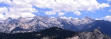
 Other notable peaks:
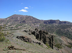
The Carson Range
(often considered part of the Sierra) extends into Nevada:
See also: List of Yosemite waterfalls
 North to south:
Eastern side of the Sierra:
California
California is a state located on the West Coast of the United States. It is by far the most populous U.S. state, and the third-largest by land area...
, USA
United States
The United States of America is a federal constitutional republic comprising fifty states and a federal district...
. Please see Sierra Nevada for alternative meanings. See also: List of books about the Sierra Nevada for further reading.
Principal Mountains
List of mountains over 14,000 ft (4250 m) with 300 ft (90 m) of prominence:- Mount WhitneyMount WhitneyMount Whitney is the highest summit in the contiguous United States with an elevation of . It is on the boundary between California's Inyo and Tulare counties, west-northwest of the lowest point in North America at Badwater in Death Valley National Park...
14,505 ft (4421 m) - Mount WilliamsonMount WilliamsonMount Williamson, at , is the second highest mountain in both the Sierra Nevada range and the state of California. It is the sixth highest peak in the contiguous United States.- Geography :...
14,403 ft (4390 m) - North PalisadeNorth PalisadeNorth Palisade is the third highest mountain in the Sierra Nevada range of California. It is the highest peak of the Palisades group of peaks in the central part of the range. It sports a small glacier and several highly prized rock climbing routes on its northeast side.- History :North Palisade...
14,242 ft (4341 m) - Mount SillMount SillMount Sill is one of the fourteeners of the Sierra Nevada in California. It is located in the Palisades, a group of striking rock peaks with a few small glaciers on their flanks. Mount Sill is located 0.6 miles east of North Palisade, the high point of the group. The two peaks are connected by a...
14,153 ft (4314 m) - Mount RussellMount Russell (California)Mount Russell is a peak in the Sierra Nevada mountain range in the U.S. state of California, about north of Mount Whitney. It rises to an elevation of and is the seventh highest peak in the state.- Geography :...
14,094 ft (4296 m) - Split Mountain 14,064 ft (4286 m)
- Mount LangleyMount LangleyMount Langley is located on the crest of the Sierra Nevada, on the boundary between Inyo and Tulare counties, in eastern California in the southwestern United States. To the east is Owens Valley, and to the west is the Kern River Valley. It is the ninth highest peak in the state and the seventh...
14,025 ft (4280 m) - Mount TyndallMount TyndallMount Tyndall is a peak in the Mount Whitney region of the Sierra Nevada in the U.S. state of California. It rises to , and is the tenth highest peak in the state...
14,019 ft (4273 m) - Middle PalisadeMiddle PalisadeMiddle Palisade is a peak in the Palisades group, part of the central Sierra Nevada mountain range in the US state of California. It is the twelfth highest peak in the state....
14,012 ft (4271 m) - Mount MuirMount MuirMount Muir is a peak in the Sierra Nevada of California, south of Mount Whitney. This peak is named for John Muir, founder of the Sierra Club, notable California geologist, and American conservationist...
14,012 ft (4271 m)
- Mount BaxterMount Baxter (California)Mount Baxter is a peak along the crest of the Sierra Nevada Mountains in California. Mount Baxter is in the John Muir Wilderness just north of Baxter Pass and to the northeast of the Rae Lakes, a popular backpacking destination along the John Muir Trail....
- Black KaweahBlack KaweahBlack Kaweah is a mountain of the Kaweah Peaks Ridge of the California's Sierra Nevada, in Sequoia National Park. The peak has a local magnetic disturbance that has caused compasses in the vicinity to vary by up to eight degrees....
- Castle PeakCastle Peak (California)Castle Peak is a mountain in California's Sierra Nevada near I-80, Donner Pass and the Nevada border. It is in the Tahoe National Forestnot far off the Pacific Crest Trail. It was originally named Mount Stanford by the Whitney Survey of 1860-74....
- Cathedral PeakCathedral Peak (California)Cathedral Peak is part of the Cathedral Range, a mountain range in the south-central portion of Yosemite National Park in eastern Mariposa and Tuolumne Counties. The range is an offshoot of the Sierra Nevada...
- El CapitanEl CapitanEl Capitan is a vertical rock formation in Yosemite National Park, located on the north side of Yosemite Valley, near its western end. The granite monolith extends about from base to summit along its tallest face, and is one of the world's favorite challenges for rock climbers.The formation was...
- Mount Conness
- Mount DanaMount DanaMount Dana is a mountain on the eastern edge of Yosemite National Park in the U.S. state of California. At an elevation of , it is the second highest mountain in Yosemite . Mount Dana is the highest peak in Yosemite that is a simple hike to the summit...
- Mount DarwinMount Darwin (California)Mount Darwin is a flat-topped mountain in the Sierra Nevada, on the border of between Fresno and Inyo counties in the Kings Canyon National Park and the Inyo National Forest of California. Two Australian geologists, Ernest Clayton Andrews and Willard D. Johnson, made the first recorded ascent on...
- Mount DavisMount Davis (California)Mount Davis is a prominent peak in the Ansel Adams Wilderness on the Inyo National Forest and south of Yosemite National Park. The peak was named in honor of Lieutenant Milton Fennimore Davis, who was with the first troops detailed to guard Yosemite National Park. Davis was the first person to...
- Fresno DomeFresno DomeFresno Dome is a dominant granite dome rising in isolation above the forest of Soquel Meadow in the Sierra National Forest in Madera County, California....
- Mount GibbsMount GibbsMount Gibbs is located in the Sierra Nevada Mountains of the U.S. state of California, south of Mount Dana. The mountain was named after Oliver Gibbs, a professor at Harvard University and friend of Josiah Whitney...
- Half DomeHalf DomeHalf Dome is a granite dome in Yosemite National Park, located in northeastern Mariposa County, California, at the eastern end of Yosemite Valley — possibly Yosemite's most familiar rock formation. The granite crest rises more than above the valley floor....
- Mount HopkinsMount Hopkins (California)Mount Hopkins is in the John Muir Wilderness north of Kings Canyon National Park. It is one of four peaks that surround Pioneer Basin, south-southeast of Mount Crocker, west-southwest of Mount Huntington and southwest of Mount Stanford. The mountain was named for Mark Hopkins, one of the...
- Mount HumphreysMount HumphreysMount Humphreys is a mountain peak in the Sierra Nevada on the Fresno-Inyo county line in the U.S. state of California. It is the highest peak in the Bishop area. The mountain was named by the California Geological Survey of 1873 for Andrew A...
- Lembert DomeLembert DomeLembert Dome is a granite dome rock formation in Yosemite National Park in the U.S. state of California The dome soars above Tuolumne Meadows and the Tuolumne River and can be hiked starting at the Tioga Road in the heart of Tuolumne Meadows, west of the Tioga Pass Entrance to Yosemite National...
- Liberty CapLiberty Cap (California)Liberty Cap is a granite dome in Yosemite National Park, California, USA which lies at the extreme northwestern margin of Little Yosemite Valley. It lies adjacent, to the north of Nevada Fall, on the John Muir Trail. It rises feet from the base of Nevada Fall to a peak elevation of . A smaller,...
- Mount Lyell
- Maggies PeakMaggies PeakMaggie's Peak is a mountain in the Sierra Nevada mountain range, to the west of Lake Tahoe. It is located in the Desolation Wilderness in El Dorado County, California. This mountain overlooks Lake Tahoe and affords very good views of the lake....
- Mammoth MountainMammoth MountainMammoth Mountain is a lava dome complex west of the town of Mammoth Lakes, California in the Inyo National Forest of Madera County and Mono County. It is home to a large ski area on the Mono County side....
- Matterhorn PeakMatterhorn PeakMatterhorn Peak is located in the Sierra Nevada, in the western U.S. state of California, at the northern boundary of Yosemite National Park. At elevation, it is the tallest peak in the craggy Alps-like Sawtooth Ridge and the northernmost peak in the Sierra Nevada. The peak also supports the...
- The MinaretsMinarets (California)The Minarets are a series of jagged peaks located in the Ritter Range, a sub-range of the Sierra Nevada Mountains in the state of California. They are easily viewed from Minaret Summit, which is accessible by auto. The peaks bear a certain resemblance to the minarets of Islamic mosques...
- Mount MorganMount Morgan (Mono County, California)Mount Morgan is a mountain in the Sherwin Range of the Sierra Nevada. It lies in Mono County, California, between McGee Canyon and Hilton Lakes. It is not to be confused with the Mount Morgan that lies southwest of Little Lakes Valley, only to the south southwest. The mountain is in the John Muir...
- Mount MorrisonMount Morrison (California)Mount Morrison is located in the Sierra Nevada, in the Sherwin Range. It rises south of Convict Lake near the town of Mammoth Lakes.-History:The mountain was named for Robert Morrison, a merchant in the town of Benton, who was killed near Convict Lake on September 23, 1871 while was acting as...
- Pyramid PeakPyramid Peak (California)Pyramid Peak is a mountain in the California's Sierra Nevada within the Crystal Range and to the west of Lake Tahoe. It is the highest point in the Desolation Wilderness. With an elevation gain of almost , the Rocky Canyon route is the mountain's most popular approach although it is very arduous....
- Red KaweahRed KaweahRed Kaweah is a mountain in California's Sequoia National Park part of the Kaweah Peaks Ridge. It is north of Mount Kaweah and South of Black Kaweah....
- Red Slate MountainRed Slate MountainRed Slate Mountain is the highest peak in the Sherwin Range, which subrange of the Sierra Nevada. It lies along the Sierra Crest that divides Fresno County from Mono County, California....
- Mount RitterMount RitterMount Ritter is located in the Sierra Nevada, in Madera County of California, in the Western United States. It is in the Ansel Adams Wilderness of the Inyo and Sierra National Forests. Mount Ritter is the 16th highest mountain peak of California.-Geography:...
- Thunderbolt Peak
- Mount Tom
Subranges
- Carson RangeCarson RangeThe Carson Range is a spur of the Sierra Nevada in eastern California and western Nevada that starts at Luther Pass and West Carson Canyon and goes to the Truckee River...
- Cathedral RangeCathedral RangeThe Cathedral Range is a mountain range immediately to the South of Tuolumne Meadows in Yosemite National Park, USA. It is a beautiful range, sculpted by glaciers out of granite. The tops of the peaks in the range were above the level of the highest glaciation, and are therefore uneroded and...
- Clark RangeClark Range (California)The Clark Range is a subrange of California's Sierra Nevada in Yosemite National Park.-Geography:The range extends in a north-south direction from Quarzite Peak to Triple Divide Peak and separates the drainage basins of the Illilouette Creek from the uppermost portions of the Merced River...
- Crystal Range
- Great Western DivideGreat Western DivideThe Great Western Divide is a Sierra Nevada mountain range that forms part of the border between the Kings Canyon and Sequoia National Parks. The High Sierra Trail crosses the range at Kaweah Gap from Sequoia National Park.- References :...
- Kaweah Peaks Ridge
- PalisadesPalisades (California Sierra)The Palisades are a group of peaks in the central part of the Sierra Nevada in the US state of California. They are located about southwest of the town of Big Pine, California...
- Ritter RangeRitter RangeThe Ritter Range is a small mountain range within California's Sierra Nevada. Most of the mountain range lies within the Ansel Adams Wilderness. The Range is easily viewed from Minaret Summit, which is accessible by auto. The Ritter Range is most easily accessible from Mammoth Lakes, where hiking...
- Sherwin RangeSherwin RangeThe Sherwin Range is a mountain range that is a part of the Sierra Nevada, in California, USA. The range is immediately to the south of the Long Valley Caldera, stretching from just south of the town of Mammoth Lakes, California to the Wheeler Crest...
Counties in the Sierra
- Alpine County, CaliforniaAlpine County, CaliforniaAlpine County is the smallest county, by population, in the U.S. state of California. As of 2010, it had a population of 1,175, all rural. There are no incorporated cities in the county. The county seat is Markleeville...
- Amador County, CaliforniaAmador County, CaliforniaAmador County is a county located in the Sierra Nevada of the U.S. state of California. As of the 2010 census, the population was 38,091. The county seat is Jackson.Amador County bills itself as "The Heart of the Mother Lode" and lies within the Gold Country...
- Butte County, CaliforniaButte County, CaliforniaButte County is a county located in the Central Valley of the US state of California, north of the state capital of Sacramento. As of the 2010 census, it had a population of 220,000. The county seat is Oroville. Butte County is the "Land of Natural Wealth and Beauty."Butte County is watered by the...
- Calaveras County, CaliforniaCalaveras County, CaliforniaCalaveras County is a county located in the Gold Country of the U.S. state of California. Calaveras is the Spanish word for skulls; the county was reportedly named for the remains of Native Americans discovered by the Spanish explorer Captain Gabriel Moraga. As of the 2010 census, the county had a...
- El Dorado County, CaliforniaEl Dorado County, CaliforniaEl Dorado County is a county located in the historic Gold Country in the Sierra Nevada Mountains and foothills of the U.S. state of California. The 2010 population was 181,058. The El Dorado county seat is in Placerville....
- Fresno County, CaliforniaFresno County, CaliforniaFresno County is a county located in the Central Valley of the U.S. state of California, south of Stockton and north of Bakersfield. As of the 2010 census, it is the tenth most populous county in California with a population of 930,450, and the sixth largest in size with an area of . The county...
- Inyo County, CaliforniaInyo County, California-National protected areas:* Death Valley National Park * Inyo National Forest * Manzanar National Historic Site-Major highways:* U.S. Route 6* U.S. Route 395* State Route 127* State Route 136* State Route 168* State Route 178...
- Kern County, CaliforniaKern County, CaliforniaSpreading across the southern end of the California Central Valley, Kern County is the fifth-largest county by population in California. Its economy is heavily linked to agriculture and to petroleum extraction, and there is a strong aviation and space presence. Politically, it has generally...
- Madera County, CaliforniaMadera County, CaliforniaMadera County is a county of the U.S. state of California, located in the Central Valley and the Sierra Nevada north of Fresno County. It comprises the Madera-Chowchilla, CA Metropolitan Statistical Area. As of the 2010 census the population was 150,865...
- Mariposa County, CaliforniaMariposa County, CaliforniaMariposa County is a county in the U.S. state of California, located in the western foothills of the Sierra Nevada mountains. It lies north of Fresno, east of Merced, and southeast of Stockton. As of the 2010 census, the population was 18,251 up from 17,130 at the 2000 census...
- Mono County, CaliforniaMono County, CaliforniaMono County is a county located in the east central portion of the U.S. state of California, to the east of the Sierra Nevada between Yosemite National Park and Nevada. As of the 2010 census, the population was 14,202, up from 12,853 at the 2000 census...
- Nevada County, CaliforniaNevada County, CaliforniaNevada County is a county located in the Sierra Nevada of California, in the Mother Lode country. As of 2010 its population was 98,764. The county seat is Nevada City.-History:Nevada County was created in 1851 from parts of Yuba County....
- Placer County, CaliforniaPlacer County, CaliforniaPlacer County is a county located in both the Sacramento Valley and Sierra Nevada regions of the U.S. state of California, in what is known as the Gold Country. It stretches from the suburbs of Sacramento to Lake Tahoe and the Nevada border. Because of the expansion of the Greater Sacramento,...
- Plumas County, CaliforniaPlumas County, CaliforniaPlumas County is a county located in the Sierra Nevada of the U.S. state of California. The county gets its name from the Spanish words for the Feather River , which flows through the county. As of the 2010 census, the population 20,007, down from 20,824 at the 2000 census...
- Sierra County, CaliforniaSierra County, CaliforniaSierra County is a county located in the Sierra Nevada of the U.S. state of California, northeast of Sacramento on the border with Nevada. As of the 2010 census the population was 3,240, down from 3,555 at the 2000 census. The county seat is Downieville....
- Tulare County, CaliforniaTulare County, CaliforniaTulare County is a county located in the Central Valley of the U.S. state of California, south of Fresno. Sequoia National Park is located in the county, as are part of Kings Canyon National Park, in its northeast corner , and part of Mount Whitney, on its eastern border...
- Tuolumne County, CaliforniaTuolumne County, CaliforniaTuolumne County is a county in the Sierra Nevada of the U.S. state of California. The northern half of Yosemite National Park is located in the eastern part of the county. As of the 2010 census, the population was 55,365, up from 54,501 at the 2000 census...
- Yuba County, CaliforniaYuba County, CaliforniaYuba County is a county located in the U.S. state of California's Central Valley, north of Sacramento, along the Feather River. As of the 2010 census, its population was 72,155. The county seat is Marysville. Yuba County is part of the Greater Sacramento area.-History:Yuba County was one of the...
The Carson Range
Carson Range
The Carson Range is a spur of the Sierra Nevada in eastern California and western Nevada that starts at Luther Pass and West Carson Canyon and goes to the Truckee River...
(often considered part of the Sierra) extends into Nevada:
- Douglas County, NevadaDouglas County, NevadaDouglas County is a county located in the northwestern part of the U.S. state of Nevada. As of 2000, the population was 41,259. As of 2010, the population was estimated to be 46,997.- History :...
- Carson City, NevadaCarson City, NevadaThe Consolidated Municipality of Carson City is the capital of the state of Nevada. The words Consolidated Municipality refer to a series of changes in 1969 which abolished Ormsby County and merged all the settlements contained within its borders into Carson City. Since that time Carson City has...
- Washoe County, NevadaWashoe County, NevadaWashoe County is a county located in the U.S. state of Nevada. The population was 421,407 at the 2010 census. Its county seat is Reno. Washoe County includes the Reno-Sparks metropolitan area.-History:...
Principal rivers
- American RiverAmerican RiverThe American River is a California watercourse noted as the site of Sutter's Mill, northwest of Placerville, California, where gold was found in 1848, leading to the California Gold Rush...
- Cosumnes RiverCosumnes RiverThe Cosumnes River is a river in northern California in the United States. It rises on the western slope of the Sierra Nevada and flows approximately into the Central Valley, emptying into the Mokelumne River in the Sacramento-San Joaquin Delta.-Name:...
- Feather RiverFeather RiverThe Feather River is the principal tributary of the Sacramento River, in the Sacramento Valley of Northern California. The river's main stem is about long. Its length to its most distant headwater tributary is about . Its drainage basin is about...
- Kern RiverKern RiverThe Kern River is a river in the U.S. state of California, approximately long. It drains an area of the southern Sierra Nevada mountains northeast of Bakersfield. Fed by snowmelt near Mount Whitney, the river passes through scenic canyons in the mountains and is a popular destination for...
- Kings RiverKings River (California)The Kings River is a major river of south-central California. About long, it drains an area of the high western Sierra Nevada and the Central Valley. A large alluvial fan has formed where the river's gradient decreases in the Central Valley so the river divides into distributaries...
- Merced RiverMerced RiverThe Merced River , in the central part of the U.S. state of California, is a -long tributary of the San Joaquin River flowing from the Sierra Nevada into the Central Valley. It is most well known for its swift and steep course through the southern part of Yosemite National Park, and the...
- Mokelumne RiverMokelumne RiverThe Mokelumne River is a river in Northern California. The Upper Mokelumne River originates in the Sierra Nevada mountain range and flows into Pardee Reservoir and then Camanche Reservoir in the Sierra foothills. The Lower Mokelumne River refers to the portion of the river below Camanche Dam...
- Sacramento RiverSacramento RiverThe Sacramento River is an important watercourse of Northern and Central California in the United States. The largest river in California, it rises on the eastern slopes of the Klamath Mountains, and after a journey south of over , empties into Suisun Bay, an arm of the San Francisco Bay, and...
- San Joaquin RiverSan Joaquin RiverThe San Joaquin River is the largest river of Central California in the United States. At over long, the river starts in the high Sierra Nevada, and flows through a rich agricultural region known as the San Joaquin Valley before reaching Suisun Bay, San Francisco Bay, and the Pacific Ocean...
- Stanislaus RiverStanislaus RiverThe Stanislaus River in California is one of the largest tributaries of the San Joaquin River. The river is long and has north, middle and south forks...
- Truckee RiverTruckee RiverThe Truckee River is a stream in the U.S. states of California and Nevada. The river is about long. Its endorheic drainage basin is about , of which about are in Nevada. The Truckee is the sole outlet of Lake Tahoe and drains part of the high Sierra Nevada, emptying into Pyramid Lake in the Great...
- Tuolumne RiverTuolumne RiverThe Tuolumne River is a California river that flows nearly from the central Sierra Nevada to the San Joaquin River in the Central Valley...
- Yuba RiverYuba RiverThe Yuba River is a tributary of the Feather River in the Sacramento Valley of the U.S. state of California. It is one of the Feather's most important branches, providing about a third of its flow. The main stem of the river is about long, and its headwaters are split into North, Middle and South...
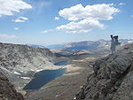
Prominent Lakes
- Lake TahoeLake TahoeLake Tahoe is a large freshwater lake in the Sierra Nevada of the United States. At a surface elevation of , it is located along the border between California and Nevada, west of Carson City. Lake Tahoe is the largest alpine lake in North America. Its depth is , making it the USA's second-deepest...
- Beardsley Lake
- Cherry LakeCherry LakeCherry Lake is an artificial lake in the Stanislaus National Forest of Tuolumne County, California about east of the city of Sonora. It is at an elevation of on the western side of the Sierra Nevada, and lies just outside the western boundary of Yosemite National Park...
- Mono LakeMono LakeMono Lake is a large, shallow saline lake in Mono County, California, formed at least 760,000 years ago as a terminal lake in a basin that has no outlet to the ocean...
- New Melones LakeNew Melones LakeNew Melones Lake is an artificial lake in the central Sierra Nevada foothills of Calaveras- and Tuolumne County, California near Jamestown. This reservoir created by the construction of the New Melones Dam across the Stanislaus River has a capacity with a surface area of...
- Pinecrest Lake
- Tioga LakeTioga LakeTioga Lake is a small glacial lake in the Inyo National Forest of Mono County, California, about two miles north of the Tioga Pass entrance to Yosemite National Park...
- Tulloch Lake
- Twain Harte Lake
Other natural features
- Devil's Postpile
- Grand Canyon of the Tuolumne RiverGrand Canyon of the TuolumneThe Grand Canyon of the Tuolumne is the portion of the valley of the Tuolumne River in Yosemite National Park, USA. As defined by the United States Geological Survey, it begins immediately below Tuolumne Meadows and ends immediately above Hetch Hetchy Valley.The Tuolumne River runs as a somewhat...
- Hetch Hetchy ValleyHetch Hetchy ValleyHetch Hetchy Valley is a glacial valley in Yosemite National Park in California. It is currently completely flooded by O'Shaughnessy Dam, forming the Hetch Hetchy Reservoir. The Tuolumne River fills the reservoir. Upstream from the valley lies the Grand Canyon of the Tuolumne. The reservoir...
- Kings CanyonKings Canyon National ParkKings Canyon National Park is a National Park in the southern Sierra Nevada, east of Fresno, California. The park was established in 1940 and covers...
- Long Valley CalderaLong Valley CalderaLong Valley Caldera is a depression in eastern California that is adjacent to Mammoth Mountain. The valley is one of the largest calderas on earth, measuring about long and wide . The elevation of the floor of the caldera is in the east and in the west...
- Owens ValleyOwens ValleyOwens Valley is the arid valley of the Owens River in eastern California in the United States, to the east of the Sierra Nevada and west of the White Mountains and Inyo Mountains on the west edge of the Great Basin section...
- San Joaquin ValleySan Joaquin ValleyThe San Joaquin Valley is the area of the Central Valley of California that lies south of the Sacramento – San Joaquin River Delta in Stockton...
- Sacramento ValleySacramento ValleyThe Sacramento Valley is the portion of the California Central Valley that lies to the north of the San Joaquin-Sacramento Delta in the U.S. state of California. It encompasses all or parts of ten counties.-Geography:...
- Tuolumne MeadowsTuolumne MeadowsTuolumne Meadows is a gentle, dome-studded sub-alpine meadowy section of the Tuolumne River, in the eastern section of Yosemite National Park. Its approximate location is . Its approximate elevation is 8619 feet .-Natural History:...
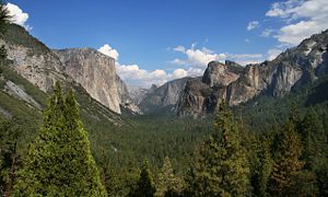
- Yosemite ValleyYosemite ValleyYosemite Valley is a glacial valley in Yosemite National Park in the western Sierra Nevada mountains of California, carved out by the Merced River. The valley is about long and up to a mile deep, surrounded by high granite summits such as Half Dome and El Capitan, and densely forested with pines...
See also: List of Yosemite waterfalls
National parks and monuments
- Yosemite National ParkYosemite National ParkYosemite National Park is a United States National Park spanning eastern portions of Tuolumne, Mariposa and Madera counties in east central California, United States. The park covers an area of and reaches across the western slopes of the Sierra Nevada mountain chain...
- Kings Canyon National ParkKings Canyon National ParkKings Canyon National Park is a National Park in the southern Sierra Nevada, east of Fresno, California. The park was established in 1940 and covers...
- Sequoia National ParkSequoia National ParkSequoia National Park is a national park in the southern Sierra Nevada east of Visalia, California, in the United States. It was established on September 25, 1890. The park spans . Encompassing a vertical relief of nearly , the park contains among its natural resources the highest point in the...
- Giant Sequoia National MonumentGiant Sequoia National MonumentThe Giant Sequoia National Monument is a U.S. National Monument located in the southern Sierra Nevada in eastern central California. It is administered by the United States Forest Service as part of the Sequoia National Forest and includes 38 of the 39 Giant Sequoia groves that are located in the...
Eastern side of the Sierra:
- Devil's Postpile National MonumentDevils Postpile National MonumentDevils Postpile National Monument is located near Mammoth Mountain in extreme northeastern Madera County in eastern California. It was established in 1911, and protects Devils Postpile, an unusual formation of columnar basalt.-Geography:...
National forests
- Eldorado National ForestEldorado National ForestEldorado National Forest is a U.S. National Forest located in the central Sierra Nevada mountain range, in eastern Eldorado National Forest is a [[U.S. National Forest]] located in the central [[Sierra Nevada |Sierra Nevada]] [[mountain range]], in eastern Eldorado National Forest is a [[U.S...
- Humboldt-Toiyabe National ForestHumboldt-Toiyabe National ForestThe Humboldt-Toiyabe National Forest is the principal U.S. National Forest located in the U.S. state of Nevada. With an area of , it is the largest National Forest of the United States outside of Alaska...
- Inyo National ForestInyo National ForestInyo National Forest is a federally administered forest in the United States. The forest covers parts of the eastern Sierra Nevada of California, and the White Mountains of California and Nevada. It contains two wilderness areas: the John Muir Wilderness and the Ansel Adams Wilderness...
- Lake Tahoe Basin Management UnitLake Tahoe Basin Management UnitThe Lake Tahoe Basin Management Unit is a unique Sierra Nevada geologic basin of federally managed land, which is interspersed with a patchwork private and state managed public land...
- Plumas National ForestPlumas National ForestPlumas National Forest is a 1,146,000-acre United States National Forest located in the Sierra Nevada, in northern California.-Geography:...
- Sequoia National ForestSequoia National ForestSequoia National Forest is located in the southern Sierra Nevada mountains of California. The U.S. National Forest is named for the majestic Giant Sequoia trees which populate 38 distinct groves within the boundaries of the forest....
- Sierra National ForestSierra National ForestSierra National Forest is a U.S. National Forest located on the western slope of central Sierra Nevada in the state of California. The forest is known for its mountain scenery and natural resources. Forest headquarters are located in Clovis, California...
- Stanislaus National ForestStanislaus National ForestStanislaus National Forest contains in four counties in the Sierra Nevada Mountains of Northern California. It was established on February 22, 1897, making it one of the oldest national forests...
- Tahoe National ForestTahoe National ForestTahoe National Forest is a U.S. National Forest located in the state of California, northwest of Lake Tahoe. It includes the peak of Sierra Buttes, near Sierra City, which has views of Mount Lassen and Mount Shasta. It is located in parts of six counties. In descending order of forestland area...
Wilderness areas
A total of over 3590000 acres (14,528.2 km²) in 24 separate areas- Ansel AdamsAnsel Adams WildernessThe Ansel Adams Wilderness is a wilderness area in the Sierra Nevada of California, USA. The wilderness is part of the Sierra and Inyo National Forests. The wilderness spans...
- Bright StarBright Star WildernessBright Star Wilderness is a wilderness area in Kern County in the U.S. state of California.The California Desert Protection Act of 1994 added the wilderness to the National Wilderness Preservation System and it is administered by the Bureau of Land Management .Bright Star Wilderness surrounds ...
- Bucks LakeBucks Lake WildernessThe Bucks Lake Wilderness is a wilderness area located in the Plumas National Forest section of the Sierra Nevada, in northeastern California, United States.-Geography:...
- Carson-IcebergCarson-Iceberg WildernessThe Carson-Iceberg Wilderness is a federal wilderness area located northeast of Stockton, California. It encompasses and was designated by the California Wilderness Act of 1984. It protects an area of High Sierra landscape with elevations from to along the Sierra Mountains from Ebbetts Pass...
- Chimney PeakChimney Peak WildernessThe Chimney Peak Wilderness is a wilderness area located northwest of Ridgecrest, in southeastern Tulare County, California. The 1994 California Desert Protection Act created the wilderness and it is managed by the Bureau of Land Management , Department of the Interior.The Chimney Peak...
- DesolationDesolation WildernessThe Desolation Wilderness is a federally protected wilderness area located along the crest of the Sierra Nevada mountain range, just southwest of Lake Tahoe in El Dorado County, California, United States. It is a popular backpacking destination, with much barren rocky terrain at the edge of the...
- Dinkey LakesDinkey Lakes WildernessThe Dinkey Lakes Wilderness is a federally designated wilderness area located northeast of Fresno, in the state of California, USA. It comprises within the Sierra National Forest and was added to the National Wilderness Preservation System by the California Wilderness Act of 1984.Elevations...
- Domeland
- EmigrantEmigrant WildernessThe Emigrant Wilderness of Stanislaus National Forest is a wilderness area in the Sierra Nevada mountains of California, USA. It is bordered by Yosemite National Park on the south, the Toiyabe National Forest on the east, and State Route 108 on the north. It is an elongated area that extends...
- Golden TroutGolden Trout WildernessThe Golden Trout Wilderness is a federally designated wilderness area in the Sierra Nevada, in Tulare County, California. It is located east of Visalia, California within Inyo National Forest and Sequoia National Forest....
- Granite Chief
- HooverHoover WildernessThe Hoover Wilderness is a wilderness area in the Inyo and Humboldt-Toiyabe National Forests. It lies to the east of the crest of the central Sierra Nevada in California, to the north and east of Yosemite National Park - a long strip of spectacular scenery stretching nearly to Sonora Pass on the...
- Jennie LakesJennie Lakes WildernessJennie Lakes Wilderness is a protected area in the Sierra Nevada, in Tulare County, California. It is located east of Fresno and managed by the US Forest Service....
- John MuirJohn Muir WildernessThe John Muir Wilderness is a wilderness area that extends along the crest of the Sierra Nevada of California, USA for , in the Inyo and Sierra National Forests. Established in 1964 by the Wilderness Act and named for naturalist John Muir, it contains...
- KaiserKaiser WildernessThe Kaiser Wilderness is a federally designated wilderness protected area located northeast of Fresno in the state of California, USA. It was added to the National Wilderness Preservation System by the United States Congress on October 19, 1976...
- KiavahKiavah WildernessThe Kiavah Wilderness is a federally designated wilderness area located in the Mojave Desert, Scodie Mountains, and Southern Sierra Nevada Mountains in Kern County, California, United States...
- Kings Canyon National ParkKings Canyon National ParkKings Canyon National Park is a National Park in the southern Sierra Nevada, east of Fresno, California. The park was established in 1940 and covers...
- MokelumneMokelumne WildernessThe Mokelumne Wilderness is a federally designated wilderness area located east of Sacramento, California. It is within the boundaries of three national forests: Stanislaus, Eldorado and Toiyabe. First protected under the Wilderness Act of 1964, the Mokelumne’s borders were expanded under the...
- MonarchMonarch WildernessThe Monarch Wilderness is a federally designated wilderness area located 70 miles east of Fresno, California, in the Sierra Nevada mountain range. It encompasses within both the Sequoia National Forest and the Sierra National Forest and is managed by the United States Forest Service...
- Owens PeakOwens Peak WildernessThe Owens Peak Wilderness is a wilderness area comprising the rugged eastern face of the Sierra Nevada Mountains. Owens Peak is the high point...
- Sacatar TrailSacatar Trail WildernessThe Sacatar Trail Wilderness is a federally designated wilderness area located northwest of Ridgecrest, California USA.It was created in 1994 with the passage of the California Desert Protection Act - Public Law 103-433 - and is managed by the Bureau of Land Management .The wilderness is in size...
- Sequoia National ParkSequoia National ParkSequoia National Park is a national park in the southern Sierra Nevada east of Visalia, California, in the United States. It was established on September 25, 1890. The park spans . Encompassing a vertical relief of nearly , the park contains among its natural resources the highest point in the...
- South SierraSouth Sierra WildernessThe South Sierra Wilderness is a federally designated wilderness protected area located northeast of Bakersfield, California.Created with the passage of the California Wilderness Act of 1984 by the U.S. Congress, it is in size, is within both the Sequoia and Inyo national forests and is managed...
- YosemiteYosemite National ParkYosemite National Park is a United States National Park spanning eastern portions of Tuolumne, Mariposa and Madera counties in east central California, United States. The park covers an area of and reaches across the western slopes of the Sierra Nevada mountain chain...
California
- Auburn State Recreation AreaAuburn State Recreation AreaAuburn State Recreation Area is a state park unit of California, USA, along of the North and Middle Forks of the American River. The state recreation area is situated on the border of Placer and El Dorado Counties in the heart of historic Gold Country. The largest city with close proximity is...
- Bodie State Historic Park
- Burton Creek State ParkBurton Creek State ParkBurton Creek State Park is a state park of California, USA, located in Placer County near Truckee.Situated on the outskirts of Tahoe City, the park offers of unpaved roadway for hiking and cross-country skiing. The park was established in 1976....
- Calaveras Big Trees State ParkCalaveras Big Trees State ParkCalaveras Big Trees State Park is a state park of California, USA, preserving two groves of giant sequoia trees. It is located northeast of Arnold, California in the middle elevations of the Sierra Nevada...
- California State Mining and Mineral Museum Park PropertyCalifornia Mining and Mineral MuseumThe California State Mining and Mineral Museum is a museum in the state park system of California, USA, interpreting the state's mineral resources and mining heritage. It is located in Mariposa on the Mariposa County fairgrounds....
- Columbia State Historic ParkColumbia State Historic ParkColumbia State Historic Park, also known as Columbia Historic District, is a California state park and National Historic Landmark District located in Columbia, California. It includes almost 30 buildings built during the California Gold Rush, most of which remain today...
- D. L. Bliss State ParkD. L. Bliss State ParkD. L. Bliss State Park is a California state park located on the west shore of Lake Tahoe approximately 25 miles north of the city of South Lake Tahoe. In 1929, the Duane Leroy Bliss family donated to the state for the park. Rubicon Point Light, the highest lighthouse in the United States, is...
- Donner Memorial State ParkDonner Memorial State ParkDonner Memorial State Park is a US state park located near Truckee, California. The park is named after the ill-fated Donner Party, and contains the Emigrant Trail Museum and the Pioneer Monument dedicated to them. The Donner Camp site at Alder Creek, where the Donner families were trapped by...
- Ed Z'berg - Sugar Pine Point State ParkSugar Pine Point LightThe Sugar Pine Point Light was a small lighthouse located on Lake Tahoe, in El Dorado County, California.-History:In 1921, various commercial interests lobbied for the replacement of the Rubicon Point Light with a light on Sugar Pine Point...
- Emerald Bay State ParkEmerald Bay State ParkEmerald Bay State Park is a state park located around Emerald Bay, a National Natural Landmark since 1968, at Lake Tahoe, California. The park is home to Eagle Falls and Vikingsholm, a 38-room mansion that is one of the finest examples of Scandinavian architecture in the United States. The park...
- Empire Mine State Historic ParkEmpire Mine State Historic ParkEmpire Mine State Historic Park is a state-protected mine and park in the Sierra Nevada Mountains in Grass Valley, California. The Empire Mine is on the National Register of Historic Places and a federal Historic District. Since 1975, California State Parks has administered and maintained the mine...
- Folsom Lake State Recreation AreaFolsom Lake State Recreation AreaFolsom Lake State Recreation Area is located on and around Folsom Lake, near the Sierra-Nevada foothills city of Folsom, California about 25 miles east of Sacramento. Latitude/Longitude: 38.7075 / -121.1549...
- Folsom Powerhouse State Historic ParkFolsom Powerhouse State Historic ParkFolsom Powerhouse State Historic Park is a historical site located in Folsom near Sacramento, California, in the United States. Built in the late 19th century by the Natoma Water and Mining Company and prison labor from Folsom Prison, the hydroelelectric powerhouse first delivered power to...
- Grover Hot Springs State ParkGrover Hot Springs State ParkGrover Hot Springs State Park is a state park in eastern California, USA that was sold to the Parks and Recreation Department in the 60's. Accessed from Markleeville...
- Indian Grinding Rock State Historic ParkIndian Grinding Rock State Historic ParkChaw'se Indian Grinding Rock State Historic Park is a historical state park located in the Sierra Nevada foothills of California, eight miles east of Jackson...
- Kings Beach State Recreation Area
- Lake Valley State Recreation Area
- Malakoff Diggins State Historic ParkMalakoff Diggins State Historic ParkMalakoff Diggins State Historic Park belongs to the California State Historic Park system, a part of the California Department of Parks and Recreation. Malakoff Diggins is the site of California's largest hydraulic mines...
- Marshall Gold Discovery State Historic ParkMarshall Gold Discovery State Historic ParkMarshall Gold Discovery State Historic Park is a California state park near Placerville, California, USA. It marks the discovery of gold by James W. Marshall at Sutter's Mill in 1848...
- Mono Lake Tufa State ReserveMono Lake Tufa State ReserveThe Mono Lake Tufa State Reserve is located near Yosemite National Park within Mono County, in eastern California. It was established in 1981 by the California State Legislature, to preserve the natural limestone "tufa tower" formations at Mono Lake.-Access:...
- Prairie City State Vehicular Recreation Area
- Railtown 1897 State Historic ParkRailtown 1897 State Historic ParkRailtown 1897 State Historic Park, and its operating entity, the Sierra Railway, is known as "The Movie Railroad." Both entities are a heritage railway and are a unit of the California State Park System. Railtown 1897 is located in Jamestown, California...
- South Yuba River State ParkSouth Yuba River State ParkSouth Yuba River State Park is located in Nevada County, California.The park consists of the 22-mile long South Yuba River Canyon running from near Edwards Crossing to Bridgeport and contains some 2,000 acres belonging to the California Department of Parks and Recreation and another 9,000 under...
- Stone Lake Park Property
- Tahoe State Recreation Area
- Ward Creek Park Property
- Washoe Meadows State Park
- Wassama Round House State Historic ParkWassama RoundhouseThe Wassama Roundhouse is a California Native American ceremonial roundhouse. It is located in the Sierra Nevada foothills, in Madera County of central California.-History:...
Nevada
- Dayton State ParkDayton State ParkDayton State Park is a state park of Nevada, USA, preserving the site of the Rock Point Stamp Mill, which was built in 1861 to process silver ore mined from the Comstock Lode. Located within the town of Dayton, it is in the Western Nevada Region of Nevada State Parks...
- Lake Tahoe-Nevada State ParkLake Tahoe-Nevada State ParkLake Tahoe – Nevada State Park is a state park of Nevada, USA, on the northeast shores of Lake Tahoe. The park comprises six management units which total . The park is in the Western Nevada Region of Nevada State Parks...
- Mormon Station State Historic ParkMormon Station State Historic ParkMormon Station Historic State Park is a state park interpreting the site of first permanent nonnative settlement in Nevada, USA. The park is located in downtown Genoa....
- Washoe Lake State ParkWashoe Lake State ParkWashoe Lake State Park is a state park of Nevada, USA, on Washoe Lake. It is between the cities of Carson City and Reno near U.S. Route 395 and just east of Lake Tahoe. It is in the Western Nevada Region of Nevada State Parks. The park is open for year-round recreation including, hunting, fishing,...
Trails and routes
- John Muir TrailJohn Muir TrailThe John Muir Trail is a long-distance trail in the Sierra Nevada mountain range of California, running between the northern terminus at Happy Isles in Yosemite Valley and the southern terminus located on the summit of Mount Whitney . For almost all of its length, the trail is in the High Sierra...
- Pacific Crest TrailPacific Crest TrailThe Pacific Crest Trail is a long-distance mountain hiking and equestrian trail on the Western Seaboard of the United States. The southern terminus is at the California border with Mexico...
- Tahoe Rim TrailTahoe Rim TrailThe Tahoe Rim Trail is a 165-mile long-distance hiking trail which forms a loop around Lake Tahoe in the Sierra Nevada and Carson ranges of California and Nevada in the United States. The trail ranges in elevation from 6,240 feet at the outlet of Lake Tahoe to 10,338 feet at Relay Peak in Nevada...
- High Sierra TrailHigh Sierra TrailThe High Sierra Trail is a hiking trail in Sequoia National Park, California. The trail crosses the Sierra Nevada from west to east.From the plateau of the Giant Forest at Crescent Meadow the trail travels high on the northern wall of the canyon of the Middle Fork of the Kaweah River to Bearpaw...
- Sierra High RouteSierra High RouteThe Sierra High Route is a cross-country hiking route, long, through the Sierra Nevada. It was scouted by Steve Roper and described by him in his book Sierra High Route: Traversing Timberline Country....
Mountain passes
- Carson PassCarson PassCarson Pass is the Sierra Crest mountain pass over which State Route 88 crosses. The historic pass was a point on the Carson Trail during the California Gold Rush and was used for American Civil War shipping to California until the completion of the First Transcontinental Railroad...
- Ebbetts PassEbbetts PassEbbetts Pass, named after John Ebbetts, is a high mountain pass through the Sierra Nevada range in Alpine County, California. Ebbetts is the eastern of two passes in the area traversed by State Route 4. The western pass is the Pacific Grade Summit . The pass is registered as California Historical...
- Forester PassForester PassForester Pass is a mountain pass in the Sierra Nevada. Located on the Kings-Kern Divide on the boundary between Sequoia National Park and Kings Canyon National Park, Forester Pass connects the drainages of Bubbs Creek and the Kern River...
- Fredonyer PassFredonyer PassFredonyer Pass is a high mountain pass in Lassen County, California. The pass is slightly higher than Morgan Summit to the west. Snow falls on the pass during winter....
- Glen PassGlen PassGlen Pass is a mountain pass in the Sierra Nevada Mountains, located in Kings Canyon National Park, eastern Fresno County, California. This pass, on the John Muir Trail, links Rae Lakes at elevation with Charlotte Lake at elevation....
- Morgan SummitMorgan SummitMorgan Summit is a mountain pass on a road shared by Highway 89 and Highway 36 in Tehama County, California. The pass is located in between the town of Mineral and Childs Meadow south of Lassen Peak and Lassen Volcanic National Park. The stated elevation of the pass varies between and . The pass...
- Muir PassMuir PassMuir Pass is a mountain pass in the Sierra Nevada of California, United States, in Kings Canyon National Park. It is named for John Muir.The pass is near the midway point of the John Muir Trail, which traverses the pass. It crosses the Goddard Divide between Mount Solomons and Mount Warlow, at an...
- Pacific Grade SummitPacific Grade SummitPacific Grade Summit, at elevation 2,454 m / 8,050 ft., is a high mountain pass on the western approach to Ebbetts Pass to the east in the Sierra Nevada range in eastern California....
- Sonora PassSonora PassSonora Pass is the second-highest highway pass in the Sierra Nevada, lower by 321 ft. than Tioga Pass to the south. State Route 108 traverses the pass.-Description:...
- Tehachapi PassTehachapi PassTehachapi Pass is a mountain pass crossing the Tehachapi Mountains in Kern County, California in the United States. The route over the pass connects the San Joaquin Valley to the Mojave Desert...
- Tioga PassTioga PassTioga Pass is a mountain pass in the Sierra Nevada mountains of California. State Route 120 runs through it, and serves as the eastern entry point for Yosemite National Park. It is the highest highway pass in California and in the Sierra Nevada. Mount Dana is to the east of the pass...
- Walker PassWalker PassWalker Pass is a mountain pass by Lake Isabella in the southern Sierra Nevada mountains. It is located in northeastern Kern County, approximately 53 mi ENE of Bakersfield and 10 mi WNW of Ridgecrest...
People related to the Sierra Nevada
- Ansel AdamsAnsel AdamsAnsel Easton Adams was an American photographer and environmentalist, best known for his black-and-white photographs of the American West, especially in Yosemite National Park....
- Lafayette BunnellLafayette BunnellLafayette Houghton Bunnell was an American physician, explorer, author, and an explorer of Yosemite Valley, born in Rochester, New York.-Biography:...
- Kit CarsonKit CarsonChristopher Houston "Kit" Carson was an American frontiersman and Indian fighter. Carson left home in rural present-day Missouri at age 16 and became a Mountain man and trapper in the West. Carson explored the west to California, and north through the Rocky Mountains. He lived among and married...
- Galen ClarkGalen ClarkGalen Clark is known as the first European American to discover the Mariposa Grove of Giant Sequoia trees, and is notable for his role in gaining legislation to protect it and the Yosemite area, and for 24 years serving as Guardian of Yosemite National Park.-Early life and education:Galen Clark...
- Norman ClydeNorman ClydeNorman Clyde was a mountaineer, mountain guide, freelance writer, nature photographer, and self trained naturalist. He is well-known for achieving over 130 first ascents, many in California's Sierra Nevada and Montana's Glacier National Park...
- Francis P. FarquharFrancis P. FarquharFrancis Peloubet Farquhar graduated from Harvard and came to San Francisco to set up in practice as a Certified Public Accountant...
- James Mason HutchingsJames Mason HutchingsJames Mason Hutchings was an American businessman and one of the principal promoters of what is now Yosemite National Park....
- Joseph LeConteJoseph LeConteJoseph Le Conte was an American geologist and professor at the University of California, Berkeley.-Biography:...
- Joseph Nisbet LeConteJoseph Nisbet LeConteJoseph Nisbet LeConte was a noted explorer of the Sierra Nevada. He was also a cartographer, a photographer and a professor of mechanical engineering. He often went by J. N. LeConte in photographs and articles...
- John MuirJohn MuirJohn Muir was a Scottish-born American naturalist, author, and early advocate of preservation of wilderness in the United States. His letters, essays, and books telling of his adventures in nature, especially in the Sierra Nevada mountains of California, have been read by millions...
- Jim SavageJim SavageJim Savage or James D. Savage, , California pioneer, 49er, businessman, American soldier in the Mexican American War, and commander of the California Militia, Mariposa Battalion in the Mariposa War, discoverer of the Yosemite Valley.-Early years:...
- Carl SharsmithCarl SharsmithCarl W. Sharsmith was an American naturalist and Yosemite park ranger, notable for his knowledge and interpretation of the natural history of the Sierra Nevada. He taught botany at various universities, and discovered a species of flower in the Sierra.-Biography:Born Karl Wilhelm Schaarschmidt II...
- Theodore SolomonsTheodore SolomonsTheodore Seixas Solomons was an explorer and early member of the Sierra Club. From 1892 to 1897 he explored and named the Mount Goddard, Evolution Valley and Evolution Basin region in what is now northern Kings Canyon National Park in eastern California...
- Walter A. Starr, Jr.Walter A. Starr, Jr.Walter A. "Pete" Starr, Jr. was an American lawyer and mountain climber.A graduate of Stanford University, Starr was a respected lawyer in San Francisco, but he is better known for his abilities as a mountain climber and an explorer of the Sierra Nevada.In August 1933, he failed to return from a...
- Chief TenayaChief TenayaChief Tenaya was a Native American chief of the Yosemite Valley people in California.-Background:Tenaya's father was the chief of the Ahwahneechee , which means "people of the Ahwahnee" . The Ahwahneechee had become a tribe distinct from the other tribes in the area...
- Snowshoe ThompsonSnowshoe ThompsonSnowshoe Thompson was a nickname for the Norwegian-American John Albert Thompson, an early resident of the Sierra Nevada of Nevada and California. He is considered the father of California skiing.-Background:...
- Josiah WhitneyJosiah WhitneyJosiah Dwight Whitney was an American geologist, professor of geology at Harvard University , and chief of the California Geological Survey...