

Stanislaus River
Encyclopedia
The Stanislaus River in California
is one of the largest tributaries of the San Joaquin River
. The river is 95.9 miles (154.3 km) long and has north, middle and south forks. It drains a long, narrow area of the western Sierra Nevada and the northern part of the San Joaquin Valley
.
and the middle fork joins the north fork a few miles before that. The Stanislaus River is extensively dam
med and diverted. Donnells Dam on the middle fork forms Donell Lake, high in the Sierra Nevada. Downstream is Beardsley Dam, which forms Beardsley Lake. McKays' Point Diversion Dam diverts water on the north fork for hydroelectricity
production and domestic use. The New Melones Dam
blocks the river after the confluence of all three forks. Downstream from New Melones Lake, there is Tulloch Dam
, which forms Tulloch Reservoir, and Goodwin Dam, located at 37°51′46"N 120°37′47"W, which is the first major barrier for anadromous fish on the Stanislaus River. In fact, the Stanislaus River historically supported a large population of spring-run chinook salmon (McEwan 1996; Yoshiyama 1996) which was extirpated with the construction of Goodwin Dam. Below Goodwin Dam, the Stanislaus eventually meets the San Joaquin River and flows into the Sacramento-San Joaquin River Delta
.
bridge before the rains brought the lake level all the way up above the put-in.
The river is named for Estanislao
, a Miwok
leader from Mission San José, who led a band of 400 former mission acolytes against the Mexican
government in 1828 and 1829. The band made its base along the banks of the river, then known as the Río de los Laquisimes. The word Laquisimes could be a Spanish
loanword
referring to the "Lakisamni", an Amerindian tribe that lived on the Stanislaus near Knights Ferry
.
contains one of the rare stands of native oak trees found in the Central Valley. Located near Ripon
, Caswell State Park is located on the Stanislaus River. There are two beaches, Salmon Beach located in the campgrounds, and Public Beach located in the day use area. Many campers will take inflatable rafts down the river starting at Salmon Beach and exiting at Public Beach. The river is also used by hobbyist gold diggers who pan the river for gold.
Frederick Russell Burnham
, the celebrated scout, was largely responsible for the Byrne's Ferry bridge being purchased by the counties. In the late 1880s and early 1890s, Burnham was a cattleman in the region and during his annual summer trips into the mountains for better feed he drove his cattle across the bridge at a cost of $25 or $30 for the herd. Because he was dissatisfied with the condition of the bridge, and because he disliked paying the toll fee, Burnham circulated a petition for the bridge to be purchased by the two counties and to be made a free bridge. In 1902, the petition passed and the counties of Calaveras
and Tuolumne
purchased the bridge for $4,000 and the toll was discontinued.
It is claimed that the Californio
bandit Tiburcio Vasquez
held up the stage running between Chinese Camp
and Copperopolis
nearby. Wells Fargo
posted a reward for his arrest and conviction and a posse was formed at Poker Flat which then crossed the Byrne's Ferry bridge in pursuit of the bandit. Vasquez escaped only to be captured later in San Jose
and hanged not long after.
The Tri-Dam project and the Tulloch Reservoir eventually ended the story of the covered bridge. When filled to capacity, the reservoir backs river water up the canyon for seven miles and forms a large lake that covers the O'Byrne's Bridge site to a depth of eighty feet. In 1957, as the reservoir began to fill, the directors of the two irrigation districts studied the possibility of either burning the bridge where it stood or simply cutting it free from its moorings. But the Calaveras and Tuolumne County Historical Societies and the Copperopolis Community Club, assisted by the Native Sons of the Golden West
and many other state-wide groups, took an interest in saving the bridge. They started what was known as a "DOLLAR" campaign to cover the cost of preserving the bridge as a future landmark; estimated at the time to be about $9,000. A plan was developed to move the bridge down-stream to a lagoon created by the reservoir where it could span an inlet and once again become a tourist attraction. The California State Parks Commission
endorsed the proposal and a Tuolumne County rancher agreed to donate the property upon which the bridge could be located. However, such plans failed to materialize.
On the morning of October 21, 1957, the Calaveras and Tuolumne County supervisors sold the bridge at auction. Several attempts were made to blast the bridge from its supports using dynamite, but the charges were insufficient. As the water rose, the bridge eventually give up its supports but by then it was partially submerged. Unable to save the bridge, the structure was dismantled and some of the lumber was used to build the nearby resorts. About 3,000 feet upstream from where the old covered bridge stood, a new concrete and steel bridge was built in 1958 at a cost of $458,355.
California
California is a state located on the West Coast of the United States. It is by far the most populous U.S. state, and the third-largest by land area...
is one of the largest tributaries of the San Joaquin River
San Joaquin River
The San Joaquin River is the largest river of Central California in the United States. At over long, the river starts in the high Sierra Nevada, and flows through a rich agricultural region known as the San Joaquin Valley before reaching Suisun Bay, San Francisco Bay, and the Pacific Ocean...
. The river is 95.9 miles (154.3 km) long and has north, middle and south forks. It drains a long, narrow area of the western Sierra Nevada and the northern part of the San Joaquin Valley
San Joaquin Valley
The San Joaquin Valley is the area of the Central Valley of California that lies south of the Sacramento – San Joaquin River Delta in Stockton...
.
Course
The north and south forks meet several miles upstream from New Melones LakeNew Melones Lake
New Melones Lake is an artificial lake in the central Sierra Nevada foothills of Calaveras- and Tuolumne County, California near Jamestown. This reservoir created by the construction of the New Melones Dam across the Stanislaus River has a capacity with a surface area of...
and the middle fork joins the north fork a few miles before that. The Stanislaus River is extensively dam
Dam
A dam is a barrier that impounds water or underground streams. Dams generally serve the primary purpose of retaining water, while other structures such as floodgates or levees are used to manage or prevent water flow into specific land regions. Hydropower and pumped-storage hydroelectricity are...
med and diverted. Donnells Dam on the middle fork forms Donell Lake, high in the Sierra Nevada. Downstream is Beardsley Dam, which forms Beardsley Lake. McKays' Point Diversion Dam diverts water on the north fork for hydroelectricity
Hydroelectricity
Hydroelectricity is the term referring to electricity generated by hydropower; the production of electrical power through the use of the gravitational force of falling or flowing water. It is the most widely used form of renewable energy...
production and domestic use. The New Melones Dam
New Melones Dam
New Melones Dam is an earth and rock filled dam across the Stanislaus River creating New Melones Lake. Situated between Calaveras and Tuolumne County, California in the Sierra Nevada foothills near Jamestown, the dam was completed in 1979 replacing the old Melones Dam.-Background:The dam was...
blocks the river after the confluence of all three forks. Downstream from New Melones Lake, there is Tulloch Dam
Tulloch Dam
Tulloch Dam is a hydroelectric dam on the Stanislaus River in central California. The dam is part of the Stanislaus River Tri-Dam project owned by the Oakdale and San Joaquin irrigation districts and was completed in 1958. It serves mainly for irrigation purposes but also has a power station with a...
, which forms Tulloch Reservoir, and Goodwin Dam, located at 37°51′46"N 120°37′47"W, which is the first major barrier for anadromous fish on the Stanislaus River. In fact, the Stanislaus River historically supported a large population of spring-run chinook salmon (McEwan 1996; Yoshiyama 1996) which was extirpated with the construction of Goodwin Dam. Below Goodwin Dam, the Stanislaus eventually meets the San Joaquin River and flows into the Sacramento-San Joaquin River Delta
Sacramento River Delta
The Sacramento-San Joaquin River Delta, or California Delta, is an expansive inland river delta and estuary in northern California in the United States. The Delta is formed at the western edge of the Central Valley by the confluence of the Sacramento and San Joaquin rivers and lies just east of...
.
History
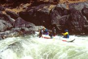
The Stanislaus is famous for a political battle over building the dam (which now forms New Melones Lake). The non-profit organization Friends of the River was formed to manage the fight, and has since worked to save rivers throughout California. Prior to the construction of the dam and the flooding of the river, the lower Stanislaus was one of the most rafted whitewater runs in the United States. Rafting is still popular on the north fork of the Stanislaus and on the Goodwin Canyon section of the main Stanislaus. In long periods of drought, the Camp Nine run comes back as the lake level drops. In the early 1990s, this section was runnable for 3 years, with the river reaching the Highway 49California State Route 49
State Route 49 is a north–south state highway in the U.S. state of California that passes through many historic mining communities of the 1849 California gold rush. Highway 49 is numbered after the "49ers", the waves of immigrants who swept into the area looking for gold, and a portion of it...
bridge before the rains brought the lake level all the way up above the put-in.
The river is named for Estanislao
Estanislao
Estanislao was an indigenous alcade of Mission San José; and a member and leader of the Lakisamni tribe of the Yokut people of northern California...
, a Miwok
Miwok
Miwok can refer to any one of four linguistically related groups of Native Americans, native to Northern California, who spoke one of the Miwokan languages in the Utian family...
leader from Mission San José, who led a band of 400 former mission acolytes against the Mexican
Mexico
The United Mexican States , commonly known as Mexico , is a federal constitutional republic in North America. It is bordered on the north by the United States; on the south and west by the Pacific Ocean; on the southeast by Guatemala, Belize, and the Caribbean Sea; and on the east by the Gulf of...
government in 1828 and 1829. The band made its base along the banks of the river, then known as the Río de los Laquisimes. The word Laquisimes could be a Spanish
Spanish language
Spanish , also known as Castilian , is a Romance language in the Ibero-Romance group that evolved from several languages and dialects in central-northern Iberia around the 9th century and gradually spread with the expansion of the Kingdom of Castile into central and southern Iberia during the...
loanword
Loanword
A loanword is a word borrowed from a donor language and incorporated into a recipient language. By contrast, a calque or loan translation is a related concept where the meaning or idiom is borrowed rather than the lexical item itself. The word loanword is itself a calque of the German Lehnwort,...
referring to the "Lakisamni", an Amerindian tribe that lived on the Stanislaus near Knights Ferry
Knights Ferry, California
Knights Ferry is a town in Stanislaus County, California, United States. Nestled in the foothills of the Sierra Nevada, it is about east of Modesto on the Stanislaus River. The Willms Ranch, a California Landmark near the town, was one of many filming locations for the television series Bonanza...
.
Caswell Memorial State Park
Caswell Memorial State ParkCaswell Memorial State Park
Caswell Memorial State Park is a state park of California, USA, preserving a riparian forest along the Stanislaus River. It is located in southern San Joaquin County southwest of the town of Ripon. Riparian Oak Woodland, located in this park, is threatened and the park is trying to protect it. It...
contains one of the rare stands of native oak trees found in the Central Valley. Located near Ripon
Ripon, California
Ripon is a city located in . The population was 14,297 at the 2010 census.-History:Ripon, on the site previously known as Murphy's Ferry, Stanislaus City, & Stanislaus Station, was renamed for , which was itself named for a city in Yorkshire, England...
, Caswell State Park is located on the Stanislaus River. There are two beaches, Salmon Beach located in the campgrounds, and Public Beach located in the day use area. Many campers will take inflatable rafts down the river starting at Salmon Beach and exiting at Public Beach. The river is also used by hobbyist gold diggers who pan the river for gold.
Covered bridges
Byrne's ferry bridge
One of the few remaining covered bridges in California crossed the Stanislaus River and was originally called the Byrne's Ferry bridge, named after the P. O. Byrne ferry which once crossed at the same point. Originally a chain cable suspension bridge with a plank floor, it was completed in the spring of 1853 and was opened to the public as a toll bridge. The suspension bridge was destroyed in the floods, and a new covered cantilever bridge of Howe truss type and reinforced by an auxiliary arch was built in 1862. Built and run by the Union Bridge Company, a corporation with headquarters at Sonora, Joe Pardies profitably operated the toll bridge for many years.Frederick Russell Burnham
Frederick Russell Burnham
Frederick Russell Burnham, DSO was an American scout and world traveling adventurer known for his service to the British Army in colonial Africa and for teaching woodcraft to Robert Baden-Powell, thus becoming one of the inspirations for the founding of the international Scouting Movement.Burnham...
, the celebrated scout, was largely responsible for the Byrne's Ferry bridge being purchased by the counties. In the late 1880s and early 1890s, Burnham was a cattleman in the region and during his annual summer trips into the mountains for better feed he drove his cattle across the bridge at a cost of $25 or $30 for the herd. Because he was dissatisfied with the condition of the bridge, and because he disliked paying the toll fee, Burnham circulated a petition for the bridge to be purchased by the two counties and to be made a free bridge. In 1902, the petition passed and the counties of Calaveras
Calaveras County, California
Calaveras County is a county located in the Gold Country of the U.S. state of California. Calaveras is the Spanish word for skulls; the county was reportedly named for the remains of Native Americans discovered by the Spanish explorer Captain Gabriel Moraga. As of the 2010 census, the county had a...
and Tuolumne
Tuolumne County, California
Tuolumne County is a county in the Sierra Nevada of the U.S. state of California. The northern half of Yosemite National Park is located in the eastern part of the county. As of the 2010 census, the population was 55,365, up from 54,501 at the 2000 census...
purchased the bridge for $4,000 and the toll was discontinued.
It is claimed that the Californio
Californio
Californio is a term used to identify a Spanish-speaking Catholic people, regardless of race, born in California before 1848...
bandit Tiburcio Vasquez
Tiburcio Vasquez
Tiburcio Vásquez was a Californio bandit who was active in California from 1854 to 1874. The Vasquez Rocks, 40 miles north of Los Angeles, were one of his many hideouts and are named for him.-Early life:...
held up the stage running between Chinese Camp
Chinese Camp, California
Chinese Camp is a census-designated place in Tuolumne County, California, United States. The population was 126 at the 2010 census, down from 146 at the 2000 census. It lies in the grassy foothills of the Sierra Nevada near the southern end of California's Gold Country.-History:Chinese Camp is the...
and Copperopolis
Copperopolis, California
Copperopolis is a census-designated place in Calaveras County, California, United States. The population was 3,671 at the 2010 census, up from 2,363 at the 2000 census. The town is located along State Route 4 and is registered as California Historical Landmark #296.- History :Unlike most of the...
nearby. Wells Fargo
Wells Fargo
Wells Fargo & Company is an American multinational diversified financial services company with operations around the world. Wells Fargo is the fourth largest bank in the U.S. by assets and the largest bank by market capitalization. Wells Fargo is the second largest bank in deposits, home...
posted a reward for his arrest and conviction and a posse was formed at Poker Flat which then crossed the Byrne's Ferry bridge in pursuit of the bandit. Vasquez escaped only to be captured later in San Jose
San Jose, California
San Jose is the third-largest city in California, the tenth-largest in the U.S., and the county seat of Santa Clara County which is located at the southern end of San Francisco Bay...
and hanged not long after.
The Tri-Dam project and the Tulloch Reservoir eventually ended the story of the covered bridge. When filled to capacity, the reservoir backs river water up the canyon for seven miles and forms a large lake that covers the O'Byrne's Bridge site to a depth of eighty feet. In 1957, as the reservoir began to fill, the directors of the two irrigation districts studied the possibility of either burning the bridge where it stood or simply cutting it free from its moorings. But the Calaveras and Tuolumne County Historical Societies and the Copperopolis Community Club, assisted by the Native Sons of the Golden West
Native Sons of the Golden West
-History:The Native Sons of the Golden West was founded July 11, 1875 by General A. M. Winn, a Virginian, as a lasting monument to the men and women of the Gold Rush Days...
and many other state-wide groups, took an interest in saving the bridge. They started what was known as a "DOLLAR" campaign to cover the cost of preserving the bridge as a future landmark; estimated at the time to be about $9,000. A plan was developed to move the bridge down-stream to a lagoon created by the reservoir where it could span an inlet and once again become a tourist attraction. The California State Parks Commission
California Department of Parks and Recreation
The California Department of Parks and Recreation, also known as California State Parks, manages the California state parks system. The system administers 278 parks and 1.4 million acres , with over of coastline; of lake and river frontage; nearly 15,000 campsites; and of hiking, biking, and...
endorsed the proposal and a Tuolumne County rancher agreed to donate the property upon which the bridge could be located. However, such plans failed to materialize.
On the morning of October 21, 1957, the Calaveras and Tuolumne County supervisors sold the bridge at auction. Several attempts were made to blast the bridge from its supports using dynamite, but the charges were insufficient. As the water rose, the bridge eventually give up its supports but by then it was partially submerged. Unable to save the bridge, the structure was dismantled and some of the lumber was used to build the nearby resorts. About 3,000 feet upstream from where the old covered bridge stood, a new concrete and steel bridge was built in 1958 at a cost of $458,355.
See also
- River Junction AVARiver Junction AVAThe River Junction AVA is an American Viticultural Area located in both San Joaquin County and Stanislaus County, California. West of the city of Modesto, the wine region is located at the confluence of the San Joaquin River and the Stanislaus River. The AVA was created as a result of a petition...