
Sierra High Route
Encyclopedia
The Sierra High Route is a cross-country hiking route, 195 miles (313.8 km) long, through the Sierra Nevada. It was scouted by Steve Roper
and described by him in his book Sierra High Route: Traversing Timberline Country.
Much of the Sierra High Route runs parallel to the John Muir Trail
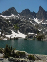
, staying east of that trail and keeping above the timberline to higher elevations—between 9000 and 11500 ft (2,743.2 and 3,505.2 m). About a third of the route follows maintained hiking trails (including 28 miles (45.1 km) of the John Muir Trail); the rest of the route traverses off-trail meadowlands, granite slabs, and, at high elevations, difficult loose-talus
terrain. Hiking the route does not require advanced mountaineering
skills, but the hiker occasionally encounters class-3
rock faces in which footholds and handholds must be carefully chosen and tested. The route requires the use of route descriptions, topographical maps, and one or more instruments (e.g., compass
, GPS receiver
) to navigate: "High Route adventurers will not be put off by the lack of an actual trail, since much of the singular joy of cross-country travel lies in wandering through the timberline country as the pioneers did".
Very few people have hiked the entire Sierra High Route in one trip. Roper divides the route into five segments:
More details about the route can be found in the "List of coordinates" section, below.
From south to north (the direction Roper recommends hiking it), the Sierra High Route passes through Kings Canyon National Park
, the Inyo National Forest
, and Yosemite National Park
.
In 2006, Backpacker
magazine editor Steve Howe hiked the entire Sierra High Route in one month.
Steve Roper
Steve Roper is a noted climber and historian of the Sierra Nevada in the United States. He along with Allen Steck are the founding editors of the Sierra Club journal Ascent.Roper is the winner of the Sierra Club's Francis P...
and described by him in his book Sierra High Route: Traversing Timberline Country.
Much of the Sierra High Route runs parallel to the John Muir Trail
John Muir Trail
The John Muir Trail is a long-distance trail in the Sierra Nevada mountain range of California, running between the northern terminus at Happy Isles in Yosemite Valley and the southern terminus located on the summit of Mount Whitney . For almost all of its length, the trail is in the High Sierra...
, staying east of that trail and keeping above the timberline to higher elevations—between 9000 and 11500 ft (2,743.2 and 3,505.2 m). About a third of the route follows maintained hiking trails (including 28 miles (45.1 km) of the John Muir Trail); the rest of the route traverses off-trail meadowlands, granite slabs, and, at high elevations, difficult loose-talus
Scree
Scree, also called talus, is a term given to an accumulation of broken rock fragments at the base of crags, mountain cliffs, or valley shoulders. Landforms associated with these materials are sometimes called scree slopes or talus piles...
terrain. Hiking the route does not require advanced mountaineering
Mountaineering
Mountaineering or mountain climbing is the sport, hobby or profession of hiking, skiing, and climbing mountains. While mountaineering began as attempts to reach the highest point of unclimbed mountains it has branched into specialisations that address different aspects of the mountain and consists...
skills, but the hiker occasionally encounters class-3
Yosemite Decimal System
The Yosemite Decimal System is a three-part system used for rating the difficulty of walks, hikes, and climbs. It is primarily used by mountaineers in the United States and Canada. The Class 5 portion of the Class scale is primarily a rock climbing classification system. Originally the system was...
rock faces in which footholds and handholds must be carefully chosen and tested. The route requires the use of route descriptions, topographical maps, and one or more instruments (e.g., compass
Compass
A compass is a navigational instrument that shows directions in a frame of reference that is stationary relative to the surface of the earth. The frame of reference defines the four cardinal directions – north, south, east, and west. Intermediate directions are also defined...
, GPS receiver
Global Positioning System
The Global Positioning System is a space-based global navigation satellite system that provides location and time information in all weather, anywhere on or near the Earth, where there is an unobstructed line of sight to four or more GPS satellites...
) to navigate: "High Route adventurers will not be put off by the lack of an actual trail, since much of the singular joy of cross-country travel lies in wandering through the timberline country as the pioneers did".
Very few people have hiked the entire Sierra High Route in one trip. Roper divides the route into five segments:
- CirqueCirqueCirque may refer to:* Cirque, a geological formation* Makhtesh, an erosional landform found in the Negev desert of Israel and Sinai of Egypt*Cirque , an album by Biosphere* Cirque Corporation, a company that makes touchpads...
Country: Cedar Grove to Dusy Basin, traversing the Monarch Divide, Lake (Cartridge CreekCartridge CreekCartridge Creek is a creek near Fresno, California. It terminates in the Middle Fork Kings River. The creek is part of Kings Canyon National Park. A pass above the headwaters of the creek has an old sheep trail over it. The creek was named by Frank Lewis while on a hunting trip in the 1870s...
) Basin, Upper Basin, Palisades Basin, Barrett Lakes Basin, and Dusy Basin. - Whitebark Country: Dusy Basin to Lake Italy, through LeConte Canyon, Muir Pass, Evolution Basin, the Glacier Divide, Humphrey's Basin, and Bear Lakes Basin.
- Lake Country: Lake Italy to Devils PostpileDevils Postpile National MonumentDevils Postpile National Monument is located near Mammoth Mountain in extreme northeastern Madera County in eastern California. It was established in 1911, and protects Devils Postpile, an unusual formation of columnar basalt.-Geography:...
by way of Bear Lakes Basin, Mono Lakes Basin, the Recesses, the Silver Divide, and the Mammoth Crest. - Headwaters Country: Devil's Postpile to Tuolumne MeadowsTuolumne MeadowsTuolumne Meadows is a gentle, dome-studded sub-alpine meadowy section of the Tuolumne River, in the eastern section of Yosemite National Park. Its approximate location is . Its approximate elevation is 8619 feet .-Natural History:...
, crossing the Ritter RangeRitter RangeThe Ritter Range is a small mountain range within California's Sierra Nevada. Most of the mountain range lies within the Ansel Adams Wilderness. The Range is easily viewed from Minaret Summit, which is accessible by auto. The Ritter Range is most easily accessible from Mammoth Lakes, where hiking...
and the Cathedral RangeCathedral RangeThe Cathedral Range is a mountain range immediately to the South of Tuolumne Meadows in Yosemite National Park, USA. It is a beautiful range, sculpted by glaciers out of granite. The tops of the peaks in the range were above the level of the highest glaciation, and are therefore uneroded and...
. Roper calls this "Headwaters Country" because the route crosses headwaters of the San Joaquin RiverSan Joaquin RiverThe San Joaquin River is the largest river of Central California in the United States. At over long, the river starts in the high Sierra Nevada, and flows through a rich agricultural region known as the San Joaquin Valley before reaching Suisun Bay, San Francisco Bay, and the Pacific Ocean...
. - Canyon Country: Tuolumne Meadows to Twin Lakes through Yosemite'sYosemite National ParkYosemite National Park is a United States National Park spanning eastern portions of Tuolumne, Mariposa and Madera counties in east central California, United States. The park covers an area of and reaches across the western slopes of the Sierra Nevada mountain chain...
north country.
More details about the route can be found in the "List of coordinates" section, below.
From south to north (the direction Roper recommends hiking it), the Sierra High Route passes through Kings Canyon National Park
Kings Canyon National Park
Kings Canyon National Park is a National Park in the southern Sierra Nevada, east of Fresno, California. The park was established in 1940 and covers...
, the Inyo National Forest
Inyo National Forest
Inyo National Forest is a federally administered forest in the United States. The forest covers parts of the eastern Sierra Nevada of California, and the White Mountains of California and Nevada. It contains two wilderness areas: the John Muir Wilderness and the Ansel Adams Wilderness...
, and Yosemite National Park
Yosemite National Park
Yosemite National Park is a United States National Park spanning eastern portions of Tuolumne, Mariposa and Madera counties in east central California, United States. The park covers an area of and reaches across the western slopes of the Sierra Nevada mountain chain...
.
In 2006, Backpacker
Backpacker (magazine)
Backpacker Magazine is an American publication that features information on wilderness hiking and adventure. It has been published since 1973. Backpacker magazine is currently published by Active Interest Media and is based in Boulder, Colorado...
magazine editor Steve Howe hiked the entire Sierra High Route in one month.