
Forester Pass
Encyclopedia
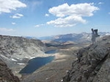
Forester Pass is a mountain pass
in the Sierra Nevada. Located on the Kings-Kern Divide on the boundary between Sequoia National Park
and Kings Canyon National Park
, Forester Pass connects the drainages of Bubbs Creek and the Kern River
. At 13153 feet (4,009 m), Forester Pass is the highest point along the Pacific Crest Trail
and the John Muir Trail
(as Trail Crest is after the southern terminus on Mount Whitney
).
Originally discovered by a group of United States Forest Service
workers, it was subsequently named in their honor.
Mountain pass
A mountain pass is a route through a mountain range or over a ridge. If following the lowest possible route, a pass is locally the highest point on that route...
in the Sierra Nevada. Located on the Kings-Kern Divide on the boundary between Sequoia National Park
Sequoia National Park
Sequoia National Park is a national park in the southern Sierra Nevada east of Visalia, California, in the United States. It was established on September 25, 1890. The park spans . Encompassing a vertical relief of nearly , the park contains among its natural resources the highest point in the...
and Kings Canyon National Park
Kings Canyon National Park
Kings Canyon National Park is a National Park in the southern Sierra Nevada, east of Fresno, California. The park was established in 1940 and covers...
, Forester Pass connects the drainages of Bubbs Creek and the Kern River
Kern River
The Kern River is a river in the U.S. state of California, approximately long. It drains an area of the southern Sierra Nevada mountains northeast of Bakersfield. Fed by snowmelt near Mount Whitney, the river passes through scenic canyons in the mountains and is a popular destination for...
. At 13153 feet (4,009 m), Forester Pass is the highest point along the Pacific Crest Trail
Pacific Crest Trail
The Pacific Crest Trail is a long-distance mountain hiking and equestrian trail on the Western Seaboard of the United States. The southern terminus is at the California border with Mexico...
and the John Muir Trail
John Muir Trail
The John Muir Trail is a long-distance trail in the Sierra Nevada mountain range of California, running between the northern terminus at Happy Isles in Yosemite Valley and the southern terminus located on the summit of Mount Whitney . For almost all of its length, the trail is in the High Sierra...
(as Trail Crest is after the southern terminus on Mount Whitney
Mount Whitney
Mount Whitney is the highest summit in the contiguous United States with an elevation of . It is on the boundary between California's Inyo and Tulare counties, west-northwest of the lowest point in North America at Badwater in Death Valley National Park...
).
Originally discovered by a group of United States Forest Service
United States Forest Service
The United States Forest Service is an agency of the United States Department of Agriculture that administers the nation's 155 national forests and 20 national grasslands, which encompass...
workers, it was subsequently named in their honor.