
John Muir Wilderness
Encyclopedia
The John Muir Wilderness is a wilderness area that extends along the crest of the Sierra Nevada of California
, USA for 90 miles (144.8 km), in the Inyo
and Sierra National Forest
s. Established in 1964 by the Wilderness Act
and named for naturalist John Muir
, it contains 581000 acres (2,351.2 km²). The wilderness lies along the eastern escarpment of the Sierra from near Mammoth Lakes
and Devil's Postpile National Monument in the north, to Cottonwood Pass near Mount Whitney
in the south. The wilderness area also spans the Sierra crest north of Kings Canyon National Park
, and extends on the west side of the park down to the Monarch Wilderness
.
, and are dramatically shaped by glacial
action. The southernmost glacier in the United States, the Palisade Glacier
, is contained within the wilderness area. Notable eastside glaciated canyons are drained by Rock
, McGee, and Bishop Creeks.
The eastern escarpment in the wilderness rises from 6000 to 8000 ft (1,828.8 to 2,438.4 m) from base to peak, in 5 to 6 mi (8 to 9.7 km). The Sierra crest contains peaks from 12000 to 14000 ft (3,657.6 to 4,267.2 m) in elevation, including Mount Whitney
, the highest peak in the continental United States. Other notable mountains in the wilderness area include the Palisades
, and Mount Humphreys
. Mount Muir
is located 2 miles south of Mount Whitney
. Mount Williamson
is the second-highest peak in the wilderness, at 14375 feet (4,381.5 m): it rises in one continuous sweep of granite from the floor of the Owens Valley
to a peak just east of the main range.
s, above 10800 feet (3,291.8 m), containing stands of whitebark
and foxtail pine
. From 9000 feet (2,743.2 m) to 10800 feet (3,291.8 m), the wilderness is dominated by lodgepole pine
s. Below the lodgepole forest is forest dominated by Jeffrey pine
.
Common animals in the wilderness include yellow-bellied marmot
s, pika
s, golden-mantled ground squirrel
s, Clark's nutcracker
s, Golden Trout
, and black bears
. The wilderness area also includes California Bighorn Sheep
Zoological Areas, which are set aside for the protection of the species.
the John Muir Trail
and the Pacific Crest Trail
which run through the wilderness from north to south. The John Muir Wilderness is the second most-visited wilderness in the United States, and quota are required for overnight use on virtually all trailheads.
California
California is a state located on the West Coast of the United States. It is by far the most populous U.S. state, and the third-largest by land area...
, USA for 90 miles (144.8 km), in the Inyo
Inyo National Forest
Inyo National Forest is a federally administered forest in the United States. The forest covers parts of the eastern Sierra Nevada of California, and the White Mountains of California and Nevada. It contains two wilderness areas: the John Muir Wilderness and the Ansel Adams Wilderness...
and Sierra National Forest
Sierra National Forest
Sierra National Forest is a U.S. National Forest located on the western slope of central Sierra Nevada in the state of California. The forest is known for its mountain scenery and natural resources. Forest headquarters are located in Clovis, California...
s. Established in 1964 by the Wilderness Act
Wilderness Act
The Wilderness Act of 1964 was written by Howard Zahniser of The Wilderness Society. It created the legal definition of wilderness in the United States, and protected some 9 million acres of federal land. The result of a long effort to protect federal wilderness, the Wilderness Act was signed...
and named for naturalist John Muir
John Muir
John Muir was a Scottish-born American naturalist, author, and early advocate of preservation of wilderness in the United States. His letters, essays, and books telling of his adventures in nature, especially in the Sierra Nevada mountains of California, have been read by millions...
, it contains 581000 acres (2,351.2 km²). The wilderness lies along the eastern escarpment of the Sierra from near Mammoth Lakes
Mammoth Lakes, California
-History:The European history of Mammoth Lakes started in 1877, when four prospectors staked a claim on Mineral Hill, south of the current town, along Old Mammoth Road. In 1878, the Mammoth Mining Company was organized to mine Mineral Hill, which caused a gold rush. By the end of 1878, 1500 people...
and Devil's Postpile National Monument in the north, to Cottonwood Pass near Mount Whitney
Mount Whitney
Mount Whitney is the highest summit in the contiguous United States with an elevation of . It is on the boundary between California's Inyo and Tulare counties, west-northwest of the lowest point in North America at Badwater in Death Valley National Park...
in the south. The wilderness area also spans the Sierra crest north of Kings Canyon National Park
Kings Canyon National Park
Kings Canyon National Park is a National Park in the southern Sierra Nevada, east of Fresno, California. The park was established in 1940 and covers...
, and extends on the west side of the park down to the Monarch Wilderness
Monarch Wilderness
The Monarch Wilderness is a federally designated wilderness area located 70 miles east of Fresno, California, in the Sierra Nevada mountain range. It encompasses within both the Sequoia National Forest and the Sierra National Forest and is managed by the United States Forest Service...
.
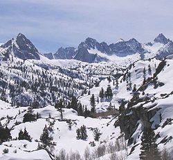
Geography and Geology
The wilderness contains the most spectacular and highest peaks of the Sierra Nevada, with 57 peaks over 13000 feet (3,962.4 m) in elevation. The peaks are typically made of granite from the Sierra Nevada BatholithSierra Nevada Batholith
The Sierra Nevada Batholith is a large batholith which forms the core of the Sierra Nevada mountain range in California, USA, exposed at the surface as granite....
, and are dramatically shaped by glacial
Glacier
A glacier is a large persistent body of ice that forms where the accumulation of snow exceeds its ablation over many years, often centuries. At least 0.1 km² in area and 50 m thick, but often much larger, a glacier slowly deforms and flows due to stresses induced by its weight...
action. The southernmost glacier in the United States, the Palisade Glacier
Palisade Glaciers
The Palisade Glacier is a glacier located on the northeast side of the Palisades within the John Muir Wilderness in the central Sierra Nevada of California. The Palisade Glacier is the largest glacier in North America....
, is contained within the wilderness area. Notable eastside glaciated canyons are drained by Rock
Rock Creek (Owens River)
Rock Creek is a stream that flows from the high Eastern Sierra Nevada to the Owens River in Mono County of eastern California. The upper watershed is in the John Muir Wilderness of the Sierra and Inyo National Forests.-Course:...
, McGee, and Bishop Creeks.
The eastern escarpment in the wilderness rises from 6000 to 8000 ft (1,828.8 to 2,438.4 m) from base to peak, in 5 to 6 mi (8 to 9.7 km). The Sierra crest contains peaks from 12000 to 14000 ft (3,657.6 to 4,267.2 m) in elevation, including Mount Whitney
Mount Whitney
Mount Whitney is the highest summit in the contiguous United States with an elevation of . It is on the boundary between California's Inyo and Tulare counties, west-northwest of the lowest point in North America at Badwater in Death Valley National Park...
, the highest peak in the continental United States. Other notable mountains in the wilderness area include the Palisades
Palisades (California Sierra)
The Palisades are a group of peaks in the central part of the Sierra Nevada in the US state of California. They are located about southwest of the town of Big Pine, California...
, and Mount Humphreys
Mount Humphreys
Mount Humphreys is a mountain peak in the Sierra Nevada on the Fresno-Inyo county line in the U.S. state of California. It is the highest peak in the Bishop area. The mountain was named by the California Geological Survey of 1873 for Andrew A...
. Mount Muir
Mount Muir
Mount Muir is a peak in the Sierra Nevada of California, south of Mount Whitney. This peak is named for John Muir, founder of the Sierra Club, notable California geologist, and American conservationist...
is located 2 miles south of Mount Whitney
Mount Whitney
Mount Whitney is the highest summit in the contiguous United States with an elevation of . It is on the boundary between California's Inyo and Tulare counties, west-northwest of the lowest point in North America at Badwater in Death Valley National Park...
. Mount Williamson
Mount Williamson
Mount Williamson, at , is the second highest mountain in both the Sierra Nevada range and the state of California. It is the sixth highest peak in the contiguous United States.- Geography :...
is the second-highest peak in the wilderness, at 14375 feet (4,381.5 m): it rises in one continuous sweep of granite from the floor of the Owens Valley
Owens Valley
Owens Valley is the arid valley of the Owens River in eastern California in the United States, to the east of the Sierra Nevada and west of the White Mountains and Inyo Mountains on the west edge of the Great Basin section...
to a peak just east of the main range.
Ecology
The John Muir wilderness contains the largest contiguous area above 10000 feet (3,048 m) in the continental United States. It contains large areas of subalpine meadows and fellfieldFellfield
A fellfield or fell field comprises the environment of a slope, usually alpine or tundra, where the dynamics of frost and of wind give rise to characteristic plant forms in scree interstices.-Soil dynamics:...
s, above 10800 feet (3,291.8 m), containing stands of whitebark
Whitebark Pine
Pinus albicaulis, known commonly as Whitebark Pine, Pitch Pine, Scrub Pine, and Creeping Pine occurs in the mountains of the Western United States and Canada, specifically the subalpine areas of the Sierra Nevada, the Cascade Range, the Pacific Coast Ranges, and the northern Rocky Mountains –...
and foxtail pine
Foxtail Pine
The Foxtail Pine is a rare pine that is endemic to California, United States, where it is found in two areas with a separate subspecies in each, the typical subsp. balfouriana in the Klamath Mountains, and subsp. austrina in the southern Sierra Nevada.-Description:Foxtail Pine is a tree to tall,...
. From 9000 feet (2,743.2 m) to 10800 feet (3,291.8 m), the wilderness is dominated by lodgepole pine
Lodgepole Pine
Lodgepole Pine, Pinus contorta, also known as Shore Pine, is a common tree in western North America. Like all pines, it is evergreen.-Subspecies:...
s. Below the lodgepole forest is forest dominated by Jeffrey pine
Jeffrey Pine
The Jeffrey Pine, Pinus jeffreyi, named in honor of its botanist documenter John Jeffrey, is a North American pine related to Ponderosa Pine.-Distribution and habitat:...
.
Common animals in the wilderness include yellow-bellied marmot
Yellow-bellied Marmot
The yellow-bellied marmot , also known as the rock chuck, is a ground squirrel in the marmot genus.-Description:...
s, pika
Pika
The pika is a small mammal, with short limbs, rounded ears, and short tail. The name pika is used for any member of the Ochotonidae, a family within the order of lagomorphs, which also includes the Leporidae . One genus, Ochotona, is recognised within the family, and it includes 30 species...
s, golden-mantled ground squirrel
Golden-mantled Ground Squirrel
The golden-mantled ground squirrel, Callospermophilus lateralis, is a type of ground squirrel found in mountainous areas of western North America. It eats seeds, nuts, berries, insects, and underground fungi. It is preyed upon by hawks, jays, weasels, foxes, bobcats, and coyotes. A typical adult...
s, Clark's nutcracker
Clark's Nutcracker
Clark's Nutcracker , sometimes referred to as Clark's Crow or Woodpecker Crow, is a passerine bird in the family Corvidae. It is slightly smaller than its Eurasian relative the Spotted Nutcracker . It is ashy-grey all over except for the black-and-white wings and central tail feathers...
s, Golden Trout
Golden Trout
The golden trout is a sub-species of the rainbow trout, and it closley resembles the juvenile Rainbow trout. The fish is also known as the California golden trout and is native to Golden Trout Creek, Volcano Creek and the South Fork Kern River. Another variant, O. m...
, and black bears
American black bear
The American black bear is a medium-sized bear native to North America. It is the continent's smallest and most common bear species. Black bears are omnivores, with their diets varying greatly depending on season and location. They typically live in largely forested areas, but do leave forests in...
. The wilderness area also includes California Bighorn Sheep
Sierra Nevada Bighorn Sheep
Sierra Nevada bighorn sheep is a subspecies of bighorn sheep. Early taxonomic schemes included herds from British Columbia to southern California in a broader subspecies Ovis canadensis californiana. More recent genetic testing has indicated that O. c...
Zoological Areas, which are set aside for the protection of the species.
Recreation
The wilderness contains 589.5 miles (948.7 km) of hiking trails, includingthe John Muir Trail
John Muir Trail
The John Muir Trail is a long-distance trail in the Sierra Nevada mountain range of California, running between the northern terminus at Happy Isles in Yosemite Valley and the southern terminus located on the summit of Mount Whitney . For almost all of its length, the trail is in the High Sierra...
and the Pacific Crest Trail
Pacific Crest Trail
The Pacific Crest Trail is a long-distance mountain hiking and equestrian trail on the Western Seaboard of the United States. The southern terminus is at the California border with Mexico...
which run through the wilderness from north to south. The John Muir Wilderness is the second most-visited wilderness in the United States, and quota are required for overnight use on virtually all trailheads.
Lakes
- Duck Lake
- Lake VirginiaLake Virginia (California)Lake Virginia is a lake in the Sierra Nevada in Fresno County, California. It drains into Fish Creek, in the Cascade Valley. The John Muir Trail passes along its northern shore. It is not to be confused with Virginia Lakes, a cluster of lakes lying to the north....
- Squaw LakeSquaw Lake (California)Squaw Lake is a small lake in the eastern Sierra Nevada, near the John Muir Trail in John Muir Wilderness. It is located west-northwest of Mount Izack Walton and north-northeast of Lake Thomas A Edison. at an altitude of . The outflow of Squaw Lake becomes Fish Creek, which eventually joins the...
See also
- List of books about the Sierra Nevada for further reading