
Emerald Bay State Park
Encyclopedia
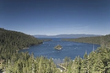
Emerald Bay State Park is a state park located around Emerald Bay, a National Natural Landmark
since 1968, at Lake Tahoe
, California
. The park is home to Eagle Falls and Vikingsholm
, a 38-room mansion that is one of the finest examples of Scandinavian architecture in the United States. The park contains the only island in Lake Tahoe, Fannette Island
. The park is accessible by State Route 89
near the southwest shore of the lake. Emerald Bay is one of Lake Tahoe's most photographed and popular locations.
In 1969, Emerald Bay was recognized as a National Natural Landmark
by the federal Department of the Interior. In 1994, California State Parks included the surrounding water of the bay as a part of the park, making Emerald Bay one of the first underwater parks of its type in the state, protecting the various wrecks and other items on the bay's bottom.
The park is located directly south of D.L. Bliss State Park.
Summer temperatures at the park range from the low 40 °F (4 °C) at night to mid-70 °F (25 °C) during the day, and during the winter visitors will usually experience temperatures between 20 and 40 °F (-7 and 4 °C). During harsh winters, the bay freezes over. The bay is about 1.7 miles (2.7 km) in length, and about two-thirds of a mile (1 km) wide at its widest point.

National Natural Landmark
The National Natural Landmark program recognizes and encourages the conservation of outstanding examples of the natural history of the United States. It is the only natural areas program of national scope that identifies and recognizes the best examples of biological and geological features in...
since 1968, at Lake Tahoe
Lake Tahoe
Lake Tahoe is a large freshwater lake in the Sierra Nevada of the United States. At a surface elevation of , it is located along the border between California and Nevada, west of Carson City. Lake Tahoe is the largest alpine lake in North America. Its depth is , making it the USA's second-deepest...
, California
California
California is a state located on the West Coast of the United States. It is by far the most populous U.S. state, and the third-largest by land area...
. The park is home to Eagle Falls and Vikingsholm
Vikingsholm
Vikingsholm is a 38-room mansion on the shore of Emerald Bay at Lake Tahoe, in El Dorado County, California, U.S., and on the National Register of Historic Places-History:...
, a 38-room mansion that is one of the finest examples of Scandinavian architecture in the United States. The park contains the only island in Lake Tahoe, Fannette Island
Fannette Island
Fannette Island is the only island in Lake Tahoe, California/Nevada, United States. It lies within Emerald Bay. Over a long period of time, it was called many different names, including Coquette, Fanette, Baranoff, Dead Man's, Hermit's, and Emerald Isle. The island contains what is left of "Tea...
. The park is accessible by State Route 89
California State Route 89
State Route 89 is a California State Highway that travels in the north–south direction, and is the major thoroughfare for many mountain communities. It starts from U.S. Route 395 near Topaz Lake, winding its way up to the Monitor Pass, down to the Carson River, and up again over the Luther...
near the southwest shore of the lake. Emerald Bay is one of Lake Tahoe's most photographed and popular locations.
In 1969, Emerald Bay was recognized as a National Natural Landmark
National Natural Landmark
The National Natural Landmark program recognizes and encourages the conservation of outstanding examples of the natural history of the United States. It is the only natural areas program of national scope that identifies and recognizes the best examples of biological and geological features in...
by the federal Department of the Interior. In 1994, California State Parks included the surrounding water of the bay as a part of the park, making Emerald Bay one of the first underwater parks of its type in the state, protecting the various wrecks and other items on the bay's bottom.
The park is located directly south of D.L. Bliss State Park.
Summer temperatures at the park range from the low 40 °F (4 °C) at night to mid-70 °F (25 °C) during the day, and during the winter visitors will usually experience temperatures between 20 and 40 °F (-7 and 4 °C). During harsh winters, the bay freezes over. The bay is about 1.7 miles (2.7 km) in length, and about two-thirds of a mile (1 km) wide at its widest point.
External links
- California State Parks
- Underwater Science Program, Indiana UniversityIndiana University BloomingtonIndiana University Bloomington is a public research university located in Bloomington, Indiana, in the United States. IU Bloomington is the flagship campus of the Indiana University system. Being the flagship campus, IU Bloomington is often referred to simply as IU or Indiana...
- Emerald Bay State Park official site
- Emerald Bay pictures
Emerald Bay State Park is a state park located around Emerald Bay, a National Natural Landmark
National Natural Landmark
The National Natural Landmark program recognizes and encourages the conservation of outstanding examples of the natural history of the United States. It is the only natural areas program of national scope that identifies and recognizes the best examples of biological and geological features in...
since 1968, at Lake Tahoe
Lake Tahoe
Lake Tahoe is a large freshwater lake in the Sierra Nevada of the United States. At a surface elevation of , it is located along the border between California and Nevada, west of Carson City. Lake Tahoe is the largest alpine lake in North America. Its depth is , making it the USA's second-deepest...
, California
California
California is a state located on the West Coast of the United States. It is by far the most populous U.S. state, and the third-largest by land area...
. The park is home to Eagle Falls and Vikingsholm
Vikingsholm
Vikingsholm is a 38-room mansion on the shore of Emerald Bay at Lake Tahoe, in El Dorado County, California, U.S., and on the National Register of Historic Places-History:...
, a 38-room mansion that is one of the finest examples of Scandinavian architecture in the United States. The park contains the only island in Lake Tahoe, Fannette Island
Fannette Island
Fannette Island is the only island in Lake Tahoe, California/Nevada, United States. It lies within Emerald Bay. Over a long period of time, it was called many different names, including Coquette, Fanette, Baranoff, Dead Man's, Hermit's, and Emerald Isle. The island contains what is left of "Tea...
. The park is accessible by State Route 89
California State Route 89
State Route 89 is a California State Highway that travels in the north–south direction, and is the major thoroughfare for many mountain communities. It starts from U.S. Route 395 near Topaz Lake, winding its way up to the Monitor Pass, down to the Carson River, and up again over the Luther...
near the southwest shore of the lake. Emerald Bay is one of Lake Tahoe's most photographed and popular locations.
In 1969, Emerald Bay was recognized as a National Natural Landmark
National Natural Landmark
The National Natural Landmark program recognizes and encourages the conservation of outstanding examples of the natural history of the United States. It is the only natural areas program of national scope that identifies and recognizes the best examples of biological and geological features in...
by the federal Department of the Interior. In 1994, California State Parks included the surrounding water of the bay as a part of the park, making Emerald Bay one of the first underwater parks of its type in the state, protecting the various wrecks and other items on the bay's bottom.
The park is located directly south of D.L. Bliss State Park.
Summer temperatures at the park range from the low 40 °F (4 °C) at night to mid-70 °F (25 °C) during the day, and during the winter visitors will usually experience temperatures between 20 and 40 °F (-7 and 4 °C). During harsh winters, the bay freezes over. The bay is about 1.7 miles (2.7 km) in length, and about two-thirds of a mile (1 km) wide at its widest point.
External links
- California State Parks
- Underwater Science Program, Indiana UniversityIndiana University BloomingtonIndiana University Bloomington is a public research university located in Bloomington, Indiana, in the United States. IU Bloomington is the flagship campus of the Indiana University system. Being the flagship campus, IU Bloomington is often referred to simply as IU or Indiana...
- Emerald Bay State Park official site
- Emerald Bay pictures