
Eldorado National Forest
Encyclopedia
Mountain range
A mountain range is a single, large mass consisting of a succession of mountains or narrowly spaced mountain ridges, with or without peaks, closely related in position, direction, formation, and age; a component part of a mountain system or of a mountain chain...
, in eastern alifornia].
Geography
Most of the forest (72.8%) lies in El Dorado CountyEl Dorado County, California
El Dorado County is a county located in the historic Gold Country in the Sierra Nevada Mountains and foothills of the U.S. state of California. The 2010 population was 181,058. The El Dorado county seat is in Placerville....
. In descending order of land area the others counties are: Amador
Amador County, California
Amador County is a county located in the Sierra Nevada of the U.S. state of California. As of the 2010 census, the population was 38,091. The county seat is Jackson.Amador County bills itself as "The Heart of the Mother Lode" and lies within the Gold Country...
, Alpine
Alpine County, California
Alpine County is the smallest county, by population, in the U.S. state of California. As of 2010, it had a population of 1,175, all rural. There are no incorporated cities in the county. The county seat is Markleeville...
, and Placer
Placer County, California
Placer County is a county located in both the Sacramento Valley and Sierra Nevada regions of the U.S. state of California, in what is known as the Gold Country. It stretches from the suburbs of Sacramento to Lake Tahoe and the Nevada border. Because of the expansion of the Greater Sacramento,...
counties in California; and Douglas County
Douglas County, Nevada
Douglas County is a county located in the northwestern part of the U.S. state of Nevada. As of 2000, the population was 41,259. As of 2010, the population was estimated to be 46,997.- History :...
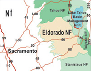
in Nevada with 78 acres (315,655.1 m²). The forest is bordered on the north by the Tahoe National Forest
Tahoe National Forest
Tahoe National Forest is a U.S. National Forest located in the state of California, northwest of Lake Tahoe. It includes the peak of Sierra Buttes, near Sierra City, which has views of Mount Lassen and Mount Shasta. It is located in parts of six counties. In descending order of forestland area...
, on the east by the Lake Tahoe
Lake Tahoe
Lake Tahoe is a large freshwater lake in the Sierra Nevada of the United States. At a surface elevation of , it is located along the border between California and Nevada, west of Carson City. Lake Tahoe is the largest alpine lake in North America. Its depth is , making it the USA's second-deepest...
Basin Management Unit, on the southeast by the Humboldt-Toiyabe National Forest
Humboldt-Toiyabe National Forest
The Humboldt-Toiyabe National Forest is the principal U.S. National Forest located in the U.S. state of Nevada. With an area of , it is the largest National Forest of the United States outside of Alaska...
, and to the south by the Stanislaus National Forest
Stanislaus National Forest
Stanislaus National Forest contains in four counties in the Sierra Nevada Mountains of Northern California. It was established on February 22, 1897, making it one of the oldest national forests...
.
Eldorado National Forest headquarters are located in Placerville, California
Placerville, California
Placerville is the county seat of El Dorado County, California. The population was 10,389 at the 2010 census, up from 9,610 at the 2000 census. It is part of the Sacramento–Arden-Arcade–Roseville Metropolitan Statistical Area.-Geography:...
. There are local ranger district offices in Camino
Camino, California
Camino is a census-designated place in El Dorado County, California, and, per the 2010 census, has a population of 1,750...
, Georgetown
Georgetown, California
Georgetown is a census-designated place in El Dorado County, California. It is the northeastern-most town in the Californian Mother Lode. The population was 2,367 at the 2010 census, up from 962 at the 2000 census...
, Pioneer
Pioneer, California
Pioneer is a census-designated place in Amador County, California. It is located east-northeast of Pine Grove, at an elevation of 2986 feet , along State Route 88. The community is in ZIP code 95666 and area code 209...
, and Pollock Pines
Pollock Pines, California
Pollock Pines is a census-designated place in El Dorado County, California, United States. It is part of the Sacramento–Arden-Arcade–Roseville Metropolitan Statistical Area...
.
Land ownership
A complicated ownership pattern exists. The parcels of Other Ownership (private or other Agency land) are mostly isolated and surrounded on all sides by government land. An opposite pattern occurs outside of the Forest Boundary where several small scattered pieces of National Forest lands are separated from the main body and surrounded by lands of Other Ownership.- Gross area: 786,994 acres (3,185 km²)
- Other ownership: 190,270 acres (770 km²)
- Net area: 596,724 acres (2,415 km²)
Elevations
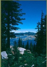
The Forest ranges in elevation from 1000 feet (304.8 m) in the foothills to more than 10000 feet (3,048 m) above sea level along the Sierra crest. The mountainous topographyTopography
Topography is the study of Earth's surface shape and features or those ofplanets, moons, and asteroids...
is broken by the steep canyon
Canyon
A canyon or gorge is a deep ravine between cliffs often carved from the landscape by a river. Rivers have a natural tendency to reach a baseline elevation, which is the same elevation as the body of water it will eventually drain into. This forms a canyon. Most canyons were formed by a process of...
s of the Mokelumne
Mokelumne River
The Mokelumne River is a river in Northern California. The Upper Mokelumne River originates in the Sierra Nevada mountain range and flows into Pardee Reservoir and then Camanche Reservoir in the Sierra foothills. The Lower Mokelumne River refers to the portion of the river below Camanche Dam...
, Cosumnes
Cosumnes River
The Cosumnes River is a river in northern California in the United States. It rises on the western slope of the Sierra Nevada and flows approximately into the Central Valley, emptying into the Mokelumne River in the Sacramento-San Joaquin Delta.-Name:...
, American
American River
The American River is a California watercourse noted as the site of Sutter's Mill, northwest of Placerville, California, where gold was found in 1848, leading to the California Gold Rush...
, and Rubicon
Rubicon River (California)
The Rubicon River is a river in the Sierra Nevada of northern California, west of Lake Tahoe. It is a tributary of the Middle Fork American River, and is long and with a watershed of about . The river's headwaters are in the Crystal Range of the Sierra Nevada, within the Eldorado National Forest's...
rivers. Plateau
Plateau
In geology and earth science, a plateau , also called a high plain or tableland, is an area of highland, usually consisting of relatively flat terrain. A highly eroded plateau is called a dissected plateau...
s of generally moderate relief are located between these steep canyons.
Climate
A cool montane version of Mediterranean climateMediterranean climate
A Mediterranean climate is the climate typical of most of the lands in the Mediterranean Basin, and is a particular variety of subtropical climate...
extends over most of the forest with warm, dry summers and cold, wet winters.
- Annual precipitation: 40 to 70 in (101.6 to 177.8 ) on average.
- Precipitation falls mainly from October through April.
- Temperature range: 0 °F (-20 °C) in winter to 100 °F (38 °C) in the summer.
- Snow pack: 5 to 10 ft (1.5 to 3 ) on average, can be as high as 15 feet (4.6 m) .
- Snow is present from December to May at elevations above 6,000 feet (1,800 m).
Vegetation
A wide variety of hardwoodHardwood
Hardwood is wood from angiosperm trees . It may also be used for those trees themselves: these are usually broad-leaved; in temperate and boreal latitudes they are mostly deciduous, but in tropics and subtropics mostly evergreen.Hardwood contrasts with softwood...
s, conifers, shrub
Shrub
A shrub or bush is distinguished from a tree by its multiple stems and shorter height, usually under 5–6 m tall. A large number of plants may become either shrubs or trees, depending on the growing conditions they experience...
s, native grass
Grass
Grasses, or more technically graminoids, are monocotyledonous, usually herbaceous plants with narrow leaves growing from the base. They include the "true grasses", of the Poaceae family, as well as the sedges and the rushes . The true grasses include cereals, bamboo and the grasses of lawns ...
es, and forb
Forb
A forb is a herbaceous flowering plant that is not a graminoid . The term is used in biology and in vegetation ecology, especially in relation to grasslands and understory.-Etymology:...
s are represented in the various Eldorado National Forest ecosystem
Ecosystem
An ecosystem is a biological environment consisting of all the organisms living in a particular area, as well as all the nonliving , physical components of the environment with which the organisms interact, such as air, soil, water and sunlight....
s.
The principle plant communities found here are:
- Interior chaparralCalifornia interior chaparral and woodlandsThe California interior chaparral and woodlands ecoregion covers in an elliptical ring around the California Central Valley. It occurs on hills and mountains ranging from to . It is part of the Mediterranean forests, woodlands, and scrub biome, with cool, wet winters and hot, dry summers...
- Oak woodlandCalifornia oak woodlandCalifornia oak woodland is a plant community found throughout the California chaparral and woodlands ecoregion of California in the United States and northwestern Baja California in Mexico...
s - Lower Montane forest — indicator speciesIndicator speciesAn indicator species is any biological species that defines a trait or characteristic of the environment. For example, a species may delineate an ecoregion or indicate an environmental condition such as a disease outbreak, pollution, species competition or climate change...
: Pinus ponderosa - Ponderosa Pine, Pinus jeffreyi - Jeffrey Pine - Upper Montane forest — indicator species: Abies magnifica - Red Fir
- Subalpine zoneSierra Nevada subalpine zoneThe Sierra Nevada subalpine zone refers to a biotic zone below treeline in the Sierra Nevada mountain range of California, United States. This subalpine zone is positioned between the upper montane zone at its lower limit, and tree line at its upper limit.The Sierra Nevada subalpine zone occurs...
.
Old-growth forests totaling 122000 acres (49,371.7 ha) have been identified in the Eldorado National Forest, consisting of:
- Sierra Nevada mixed conifer forests
- Coast Douglas-firCoast Douglas-firPseudotsuga menziesii, known as Douglas-fir, Oregon Pine, or Douglas spruce, is an evergreen conifer species native to western North America. Its variety Pseudotsuga menziesii var. menziesii, also known as coast Douglas-fir grows in the coastal regions, from west-central British Columbia, Canada...
(Pseudotsuga menziesii var. menziesii) - Ponderosa PinePonderosa PinePinus ponderosa, commonly known as the Ponderosa Pine, Bull Pine, Blackjack Pine, or Western Yellow Pine, is a widespread and variable pine native to western North America. It was first described by David Douglas in 1826, from eastern Washington near present-day Spokane...
(Pinus ponderosa) - White FirWhite FirWhite Fir is a fir native to the mountains of western North America, occurring at altitudes of 900-3,400 m. It is a medium to large evergreen coniferous tree growing to 25–60 m tall and with a trunk diameter of up to 2 m . It is popular as an ornamental landscaping tree and as a Christmas Tree...
(Abies concolor)
- Coast Douglas-fir
- and
- Lodgepole PineLodgepole PineLodgepole Pine, Pinus contorta, also known as Shore Pine, is a common tree in western North America. Like all pines, it is evergreen.-Subspecies:...
(Pinus contorta) forests - Red FirRed FirAbies magnifica, the Red Fir or Silvertip fir, is a western North American fir, native to the mountains of southwest Oregon and California in the United States. It is a high altitude tree, typically occurring at altitude, though only rarely reaching tree line...
(Abies magnifica) forests
- Lodgepole Pine
Logging
The major commercial Forest species are White Fir, Red Fir, Ponderosa Pine, Jeffrey pine, Sugar PineSugar Pine
Pinus lambertiana, commonly known as the sugar pine or sugar cone pine, is the tallest and most massive pine, with the longest cones of any conifer...
, Douglas Fir, and Incense Cedar.
Water
Water is a major resource of the Eldorado National Forest. The forest receives about 56 inches (142.2 cm) of precipitationPrecipitation (meteorology)
In meteorology, precipitation In meteorology, precipitation In meteorology, precipitation (also known as one of the classes of hydrometeors, which are atmospheric water phenomena is any product of the condensation of atmospheric water vapor that falls under gravity. The main forms of precipitation...
annually. Average annual runoff is about 29 inches (73.7 cm) . This is equal to an annual water yield of 2.4 acre.ft per acre (737,000 m³/km²); therefore National Forest lands yield an estimated 1444000 acre.ft annually. of fishable
Fishing
Fishing is the activity of trying to catch wild fish. Fish are normally caught in the wild. Techniques for catching fish include hand gathering, spearing, netting, angling and trapping....
stream
Stream
A stream is a body of water with a current, confined within a bed and stream banks. Depending on its locale or certain characteristics, a stream may be referred to as a branch, brook, beck, burn, creek, "crick", gill , kill, lick, rill, river, syke, bayou, rivulet, streamage, wash, run or...
s in four major drainage systems: Middle Fork of the American River (including the Rubicon), South Fork of the American River, Cosumnes River, and North Fork of the Mokelumne River.
- 297 lakeLakeA lake is a body of relatively still fresh or salt water of considerable size, localized in a basin, that is surrounded by land. Lakes are inland and not part of the ocean and therefore are distinct from lagoons, and are larger and deeper than ponds. Lakes can be contrasted with rivers or streams,...
s and reservoirs (including both public and private land), which total 11,994 acres (48.5 km²). 11 large reservoirs account for 9,000 acres (36 km²). The rest are mostly small, high mountain lakes.
Transportation
The Eldorado National Forest has a high density of transportation routes, with 2367 miles (3,809.3 km) of roads, and 349 miles (561.7 km) of trails. Roads under Forest Service jurisdiction total 2158 miles (3,473 km). There are 209 miles (336.4 km) of county roads, and 400 miles (643.7 km) of private roads within the National Forest boundaries.History
The forest was established on July 28, 1910 from a portion of Tahoe National ForestTahoe National Forest
Tahoe National Forest is a U.S. National Forest located in the state of California, northwest of Lake Tahoe. It includes the peak of Sierra Buttes, near Sierra City, which has views of Mount Lassen and Mount Shasta. It is located in parts of six counties. In descending order of forestland area...
and other lands.
See also
- List of plants of the Sierra Nevada (U.S.)
- Index: Fauna of the Sierra Nevada (U.S.)