

Parramatta Road
Encyclopedia
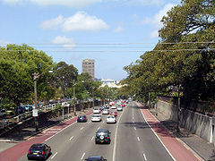
Parramatta Road is the major historical east-west artery of metropolitan Sydney
Sydney
Sydney is the most populous city in Australia and the state capital of New South Wales. Sydney is located on Australia's south-east coast of the Tasman Sea. As of June 2010, the greater metropolitan area had an approximate population of 4.6 million people...
, Australia
Australia
Australia , officially the Commonwealth of Australia, is a country in the Southern Hemisphere comprising the mainland of the Australian continent, the island of Tasmania, and numerous smaller islands in the Indian and Pacific Oceans. It is the world's sixth-largest country by total area...
, connecting the Sydney
Sydney central business district
The Sydney central business district is the main commercial centre of Sydney, New South Wales, Australia. It extends southwards for about 3 kilometres from Sydney Cove, the point of first European settlement. Its north–south axis runs from Circular Quay in the north to Central railway station in...
with Parramatta
Parramatta, New South Wales
Parramatta is a suburb of Sydney, in the state of New South Wales, Australia. It is located in Greater Western Sydney west of the Sydney central business district on the banks of the Parramatta River. Parramatta is the administrative seat of the Local Government Area of the City of Parramatta...
. It is the eastern-most part of the Great Western Highway
Great Western Highway
The Great Western Highway is a highway in New South Wales, Australia. It runs 210 km from Sydney to Bathurst.Starting as Broadway at the intersection of City Road near the fringe of the Sydney CBD, and becoming Parramatta Road to Parramatta itself, the Great Western Highway heads due west from...
. Much of its traffic has been diverted to modern expressways such as the M4
Metroad 4
Metroad 4 is a Metroad in Sydney, New South Wales, Australia. It connects the inner-west of Sydney with the outer western suburbs. It mostly follows what was previously National Highway 32 from the Western Distributor in the CBD, west to the Great Western Highway at Lapstone...
and the City West Link Road
City West Link Road
City West Link Road is a link road in Sydney, Australia. It makes up a section of Metroad 4 between Leichhardt, Haberfield and Five Dock. As such, it provides an alternative route to Parramatta Road into Sydney's CBD from the Inner-West....
.
Parramatta Road has rarely been considered beautiful. A local mayor once described it as a "varicose vein". However it has never been considered unimportant. One commentator has said: "Every chapter of Sydney's history has been written on Parramatta Road".
It begins in the east as a continuation of George Street
George Street, Sydney
George Street is one of Sydney's most notable city streets. There are more high rise buildings and more ASX 100 companies located here than anywhere else in Australia, and is well known for being busy around-the-clock...
and Broadway
Broadway, New South Wales
Broadway is a road in Sydney, in the state of New South Wales, Australia. The road constitutes the border between the suburbs of Ultimo and Chippendale . Broadway is also an urban locality....
(Broadway becomes Parramatta Road just west of the intersection with City Road
City Road, Sydney
City Road is a large thoroughfare in Sydney, New South Wales, Australia. City Road runs south from a junction with Broadway and Parramatta Road, through the University of Sydney and becomes King Street as it enters the suburb of Newtown....
), and skirts the southern contours of Sydney Harbour and the Parramatta River
Parramatta River
The Parramatta River is a waterway in Sydney, New South Wales, Australia. The Parramatta River is the main tributary of Sydney Harbour, a branch of Port Jackson, along with the smaller Lane Cove and Duck Rivers....
to Parramatta. The highway forms the boundaries of various suburbs along the way and ends at the junction of Church Street, Parramatta, where the Great Western Highway briefly turns to the north.
Parramatta Road forms the southern boundary of the following suburbs:
- UltimoUltimo, New South WalesUltimo is an inner-city suburb of Sydney, New South Wales, Australia. Ultimo is located 2 kilometres south-west of the Sydney central business district in the local government area of the City of Sydney....
- GlebeGlebe, New South WalesGlebe is an inner-city suburb of Sydney. Glebe is located 3 km south-west of the Sydney central business district and is part of the local government area of the City of Sydney, in the Inner West region....
- Forest LodgeForest Lodge, New South WalesForest Lodge is a small, inner-city suburb of Sydney, in the state of New South Wales, Australia. Forest Lodge is located 4 kilometres south-west of the Sydney central business district and is part of the local government area of the City of Sydney...
- AnnandaleAnnandale, New South WalesAnnandale is a suburb of Inner West Sydney in the state of New South Wales, Australia. Annandale is located within 3-5 kilometres west of the Sydney central business district and is part of the local government area of the Municipality of Leichhardt. Annandale's northern end lies on Rozelle Bay,...
- LeichhardtLeichhardt, New South WalesLeichhardt is a suburb in the inner-west of Sydney in New South Wales, Australia. Leichhardt is located 5 kilometres west of the Sydney central business district and is the administrative centre for the local government area of the Municipality of Leichhardt...
- HaberfieldHaberfield, New South WalesHaberfield is a suburb in the inner-west of Sydney, in the state of New South Wales, Australia. Haberfield is located 9 kilometres west of the Sydney central business district in the local government area of the Municipality of Ashfield....
- Five DockFive Dock, New South WalesFive Dock is a suburb in the inner-west of Sydney, in the state of New South Wales, Australia. Five Dock is located 10 kilometres west of the Sydney central business district, in the Local Government Area of the City of Canada Bay.-Location:...
- ConcordConcord, New South WalesConcord is a suburb in the inner west of Sydney, in the state of New South Wales, Australia. It is located 15 kilometres west of the Sydney central business district, in the local government area of the City of Canada Bay....
Parramatta Road forms the northern boundary of the following suburbs:
- ChippendaleChippendale, New South WalesChippendale is a small inner-city suburb of Sydney, New South Wales, Australia. Chippendale is located on the southern edge of the Sydney central business district, in the local government area of the City of Sydney...
- CamperdownCamperdown, New South WalesCamperdown is an inner-city suburb of Sydney, in the state of New South Wales, Australia. Camperdown is located 4 kilometres south-west of the Sydney central business district and is part of the Inner West region...
- StanmoreStanmore, New South WalesStanmore is a suburb in the inner-west of Sydney, in New South Wales, Australia. Stanmore is located 6 kilometres south-west of the Sydney central business district and is part of the local government area of Marrickville Council.-History:...
- LewishamLewisham, New South WalesLewisham is a suburb in the inner-west of Sydney, in the state of New South Wales, Australia. Lewisham is located 8 kilometres south-west of the Sydney central business district, in the local government area of Marrickville Council. The postcode is 2049...
- PetershamPetersham, New South WalesPetersham is a suburb in the Inner West of Sydney, in the state of New South Wales, Australia. Petersham is located 6 kilometres south-west of the Sydney central business district, in the local government area of Marrickville Council...
- Summer HillSummer Hill, New South WalesSummer Hill is a suburb of Sydney, in the state of New South Wales, Australia. Summer Hill is located 8 kilometres west of the Sydney central business district, in the local government area of the Municipality of Ashfield....
- AshfieldAshfield, New South WalesAshfield is a suburb in the inner-west of Sydney, in the state of New South Wales, Australia. Ashfield is about 9 kilometres south-west of the Sydney central business district and is the administrative centre for the local government area of the Municipality of Ashfield.The official name for the...
- CroydonCroydon, New South WalesCroydon is an affluent suburb in the inner-west of Sydney, in the state of New South Wales, Australia. Croydon is located 11 kilometres west of the Sydney central business district. Croydon is split between the two local government areas of Burwood Council and the Municipality of Ashfield.The...
- BurwoodBurwood, New South WalesBurwood is a suburb in the inner-west of Sydney, in the state of New South Wales, Australia. Burwood is located 12 kilometres west of the Sydney central business district and is the administrative centre for the local government area of Burwood Council....
West of Concord and Burwood, Parramatta Road passes through Strathfield
Strathfield, New South Wales
Strathfield is an Inner West suburb of Sydney, in the state of New South Wales, Australia. Strathfield is located 14 kilometres west of the Sydney central business district and is the administrative centre of the local government area of the Municipality of Strathfield...
, Homebush
Homebush, New South Wales
Homebush is an inner western suburb of Sydney, in the state of New South Wales, Australia. Homebush is located 15 kilometres west of the Sydney central business district, in the local government area of the Municipality of Strathfield. Homebush West and Homebush Bay are separate suburbs...
, Auburn
Auburn, New South Wales
Auburn is a suburb in western Sydney, in the state of New South Wales Australia. Auburn is located 19 kilometres west of the Sydney central business district and is the administrative centre of the local government area of Auburn Council.-History:...
and Granville
Granville, New South Wales
Granville, is a suburb in western Sydney, Australia. Granville is located west of the Sydney central business district, in the local government area of the City of Parramatta. A small part in the north-west is located in the Local Government Area of the City of Holroyd.South Granville is a...
before reaching Parramatta.
History
Parramatta was settled by Europeans in the same year (1788) as Sydney. The Parramatta River was used as navigation between them.The early track was poorly built and poorly maintained. In 1794, the governor reported that he had caused a very good road to be made, but there is no evidence that any bridges were built over the streams. On 9 June 1805, the Sydney Gazette reported that the road was impassable as the result of heavy rain. Attempts to improve the road continued over the years. Eventually, Governor Macquarie called tenders for the repair of the road raised a 3 shilling per gallon levy on spirits and levied a toll to pay for the work. The road was to be 10 metres wide. This turnpike road was opened on 10 April 1811. The toll barriers were at the present Railway Square and at Becket's Creek (near Parramatta). Heavy rain again nearly destroyed this road, so in 1817 it was announced that all tree-stumps would be removed and the road paved with stone which would be covered with earth and gravel. This improvement was announced as finished on 15 January 1815. In 1815 the "profit" from the Sydney toll reached £465. The growth of Sydney caused the toll barrier to be moved to Grose Farm (present University of Sydney) in April 1836. In 1839 it was moved further west to Annandale.
In 1814, a stage cart service was established along Parramatta Road. Sydney's oldest road and Australia's first intercity highway, fares were 10 shillings for passengers and 3 pence for letters. The colony's first stage coach (valued at £300) was imported in 1821 but did not begin regular service until 1823. The stage left the city at 7am, arrived in Parramatta at 9:30am and left Parramatta for the return journey at 4pm. Inside passengers were charged 6 shillings. Hazards on the road included aborigines and bushrangers. Hotels and settlements sprang up along the road.
Bathurst, New South Wales
-CBD and suburbs:Bathurst's CBD is located on William, George, Howick, Russell, and Durham Streets. The CBD is approximately 25 hectares and surrounds two city blocks. Within this block layout is banking, government services, shopping centres, retail shops, a park* and monuments...
. The importance of the road declined with the advent of the railway in 1855.
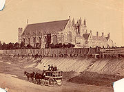
In the 1800's, the completion of several necessary extensions to the road was heavily reliant on the result of a sale between the Sisters of the Good Samaritan
Sisters of the Good Samaritan
The Congregation of the Sisters of the Good Samaritan is a Roman Catholic Congregation of religious women commenced by , Australia’s first Catholic bishop, in Sydney in 1857. The congregation was the first religious congregation to be founded in Australia. The sisters form an apostolic institute...
, Australia's first religious congregation, and the Government. The Burwood-Ashfield section of the road was previously a part of the Rosebank Estate (today known as Rosebank College
Rosebank College
Rosebank College is a private, co-educational, secondary Catholic day school in the Benedictine tradition, located in Five Dock, an inner-western suburb of Sydney, New South Wales, Australia....
), which at that time was home to the most prestigious boarding school in New South Wales
New South Wales
New South Wales is a state of :Australia, located in the east of the country. It is bordered by Queensland, Victoria and South Australia to the north, south and west respectively. To the east, the state is bordered by the Tasman Sea, which forms part of the Pacific Ocean. New South Wales...
. They agreed and sold the land to allow construction. The campus of the historic heritage-listed private school is now located adjactent to the road.
In 1883, a steam tram line opened to Annandale along Parramatta Road, and was extended to Short Street, Leichhardt via Norton Street in 1884. This line was electrified in 1901. Thereafter, the Sydney Municipal Council set about widening the major routes into the city. The Sydney end of Parramatta Road (which lies in a cutting) was widened and improved in 1910-1911.
The 20th century also saw the advent of motorised traffic on the road, and in the 1920s, the surface of the road was sealed and trams were removed from the road.
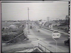
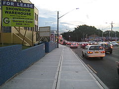
Today, over 3 million commuters every year drive Parramatta Road. The road is the hub of Sydney's motor dealership industry - with 67% of the adjacent land use devoted to motor retailing and services.