

Outback
Encyclopedia
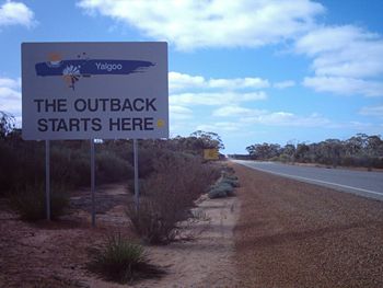
The Outback is the vast, remote, arid area of Australia
Australia
Australia , officially the Commonwealth of Australia, is a country in the Southern Hemisphere comprising the mainland of the Australian continent, the island of Tasmania, and numerous smaller islands in the Indian and Pacific Oceans. It is the world's sixth-largest country by total area...
, term colloquially can refer to any lands outside the main urban area
Urban area
An urban area is characterized by higher population density and vast human features in comparison to areas surrounding it. Urban areas may be cities, towns or conurbations, but the term is not commonly extended to rural settlements such as villages and hamlets.Urban areas are created and further...
s. The term "the outback" is generally used to refer to locations that are comparatively more remote than those areas named "the bush
The Bush
"The bush" is a term used for rural, undeveloped land or country areas in certain countries.-Australia:The term is iconic in Australia. In reference to the landscape, "bush" describes a wooded area, intermediate between a shrubland and a forest, generally of dry and nitrogen-poor soil, mostly...
".
Overview
The outback is home to a diverse set of animal species, such as the kangarooKangaroo
A kangaroo is a marsupial from the family Macropodidae . In common use the term is used to describe the largest species from this family, especially those of the genus Macropus, Red Kangaroo, Antilopine Kangaroo, Eastern Grey Kangaroo and Western Grey Kangaroo. Kangaroos are endemic to the country...
, emu
Emu
The Emu Dromaius novaehollandiae) is the largest bird native to Australia and the only extant member of the genus Dromaius. It is the second-largest extant bird in the world by height, after its ratite relative, the ostrich. There are three subspecies of Emus in Australia...
and dingo
Dingo
The Australian Dingo or Warrigal is a free-roaming wild dog unique to the continent of Australia, mainly found in the outback. Its original ancestors are thought to have arrived with humans from southeast Asia thousands of years ago, when dogs were still relatively undomesticated and closer to...
. The Dingo Fence
Dingo Fence
The Dingo Fence or Dog Fence is a pest-exclusion fence that was built in Australia during the 1880s and finished in 1885, to keep dingoes out of the relatively fertile south-east part of the continent and protect the sheep flocks of southern Queensland. It is one of the longest structures in the...
was built to restrict dingo movements into agricultural areas towards the south east of the continent. The marginally fertile parts are primarily utilised as rangeland
Rangeland
Rangelands are vast natural landscapes in the form of grasslands, shrublands, woodlands, wetlands, and deserts. Types of rangelands include tallgrass and shortgrass prairies, desert grasslands and shrublands, woodlands, savannas, chaparrals, steppes, and tundras...
s and have been traditionally used for sheep or cattle grazing, on cattle station
Cattle station
Cattle station is an Australian term for a large farm , whose main activity is the rearing of cattle. In Australia, the owner of a cattle station is called a grazier...
s which are leased
Pastoral lease
A pastoral lease is Crown land that government allows to be leased, generally for the purposes of farming.-Australia:Pastoral leases exist in both Australian commonwealth law and state jurisdictions....
from the Federal Government. While small areas of the outback consist of clay soils
Vertisol
In both the FAO and USA soil taxonomy, a vertisol is a soil in which there is a high content of expansive clay known as montmorillonite that forms deep cracks in drier seasons or years. Alternate shrinking and swelling causes self-mulching, where the soil material consistently mixes itself, causing...
the majority has exceedingly infertile palaeosols. Riversleigh
Riversleigh
Riversleigh, in North West Queensland, is Australia's most famous fossil site. The 100 km² area has fossil remains of ancient mammals, birds and reptiles of Oligocene and Miocene age...
, in Queensland, is one of Australia's most renowned fossil sites and was recorded as a World Heritage site in 1994. The 100 km² (39 sq mi) area contains fossil remains of ancient mammals, birds and reptiles of Oligocene
Oligocene
The Oligocene is a geologic epoch of the Paleogene Period and extends from about 34 million to 23 million years before the present . As with other older geologic periods, the rock beds that define the period are well identified but the exact dates of the start and end of the period are slightly...
and Miocene
Miocene
The Miocene is a geological epoch of the Neogene Period and extends from about . The Miocene was named by Sir Charles Lyell. Its name comes from the Greek words and and means "less recent" because it has 18% fewer modern sea invertebrates than the Pliocene. The Miocene follows the Oligocene...
age.
History
Early European exploration of inland Australia was sporadic. More focus was on the more accessible and fertile coastal areas. The first party to successfully cross the Blue Mountains just outside Sydney was led by Gregory BlaxlandGregory Blaxland
Gregory Blaxland was a pioneer farmer and explorer in Australia.- Early life :Gregory Blaxland was born 17 June 1778 at Fordwich, Kent, England, the fourth son of John Blaxland, mayor from 1767 to 1774, whose family had owned estates nearby for generations, and Mary, daughter of Captain Parker,...
in 1813, 25 years after the colony was established. People starting with John Oxley
John Oxley
John Joseph William Molesworth Oxley was an explorer and surveyor of Australia in the early period of English colonisation.October 1802 he was engaged in coastal survey work including an expedition to Western Port in 1804-05...
in 1817, 1818 and 1821, followed by Charles Sturt
Charles Sturt
Captain Charles Napier Sturt was an English explorer of Australia, and part of the European Exploration of Australia. He led several expeditions into the interior of the continent, starting from both Sydney and later from Adelaide. His expeditions traced several of the westward-flowing rivers,...
in 1829–1830 attempted to follow the westward-flowing rivers to find an "inland sea", but these were found to all flow into the Murray River
Murray River
The Murray River is Australia's longest river. At in length, the Murray rises in the Australian Alps, draining the western side of Australia's highest mountains and, for most of its length, meanders across Australia's inland plains, forming the border between New South Wales and Victoria as it...
and Darling River
Darling River
The Darling River is the third longest river in Australia, measuring from its source in northern New South Wales to its confluence with the Murray River at Wentworth, New South Wales. Including its longest contiguous tributaries it is long, making it the longest river system in Australia.The...
which turn south.
Over the period 1858 to 1861, John McDouall Stuart
John McDouall Stuart
John McDouall Stuart was one of the most accomplished and famous of all Australia's inland explorers. Stuart led the first successful expedition to traverse the Australian mainland from south to north and return, and the first to do so from a starting point in South Australia, achieving this...
led six expeditions north from Adelaide into the outback, culminating in successfully reaching the north coast of Australia and returning, without the loss of any of the party's members' lives. This contrasts with the ill-fated Burke and Wills expedition
Burke and Wills expedition
In 1860–61, Robert O'Hara Burke and William John Wills led an expedition of 19 men with the intention of crossing Australia from Melbourne in the south to the Gulf of Carpentaria in the north, a distance of around 3,250 kilometres...
in 1860–61 which was much better funded, but resulted in the deaths of three of the four members of the transcontinental party.
The Overland Telegraph line was constructed in the 1870s along the route identified by Stuart, who had found enough water to support the needed repeater stations.
Exploration of the outback continued in the 1950s when Len Beadell
Len Beadell
Leonard Beadell OAM BEM FIEMS was a surveyor, roadbuilder , bushman, artist and author, responsible for opening up the last remaining isolated desert areas of central Australia from 1947 to 1963. Len is sometimes called "the last true Australian explorer"...
explored, surveyed and built many roads in support of the nuclear weapons tests at Emu Field
Emu Field
Emu Field is located in the desert of South Australia, at . Variously known as Emu Field, Emu Junction or Emu, it was the site of the Operation Totem pair of nuclear tests conducted by the British government in October 1953.The site was surveyed by Len Beadell in 1952...
and Maralinga
Maralinga, South Australia
Maralinga, South Australia in the remote western areas of South Australia was the home of the Maralinga Tjarutja, a southern Pitjantjatjara Indigenous Australian people. Maralinga was the site of the secret British nuclear tests in the 1950s. The site measures about 3,300 km² in area...
and rocket testing on the Woomera Prohibited Area. Mineral exploration continues as new mineral deposits are identified and developed.
While the early explorers used horses to cross the outback, the first woman to make the journey riding a horse was Anna Hingley
Anna Hingley
Anna Hingley, is the first woman to ride on horseback across the Australian Outback, which she completed on 5 August 2006. The 3510 km journey was undertaken to raise for Angel Flight, an Australian charity that co-ordinates non emergency flights for financially and medically needy...
, who rode from Broome
Broome, Western Australia
Broome is a pearling and tourist town in the Kimberley region of Western Australia, north of Perth. The year round population is approximately 14,436, growing to more than 45,000 per month during the tourist season...
to Cairns in 2006.
Mining
Other than agriculture and tourism, the main economic activity in this vast and sparsely settled area is mining. Owing to the complete absence of mountain building and glaciation since the PermianPermian
The PermianThe term "Permian" was introduced into geology in 1841 by Sir Sir R. I. Murchison, president of the Geological Society of London, who identified typical strata in extensive Russian explorations undertaken with Edouard de Verneuil; Murchison asserted in 1841 that he named his "Permian...
(in many areas since the Cambrian
Cambrian
The Cambrian is the first geological period of the Paleozoic Era, lasting from Mya ; it is succeeded by the Ordovician. Its subdivisions, and indeed its base, are somewhat in flux. The period was established by Adam Sedgwick, who named it after Cambria, the Latin name for Wales, where Britain's...
) ages, the outback is extremely rich in iron, aluminium, manganese
Manganese
Manganese is a chemical element, designated by the symbol Mn. It has the atomic number 25. It is found as a free element in nature , and in many minerals...
and uranium ores, and also contains major deposits of gold, nickel, iron, lead and zinc ores. Because of its size, the value of grazing and mining is considerable. Major mines and mining areas in the outback include opals at Coober Pedy
Coober Pedy, South Australia
Coober Pedy is a town in northern South Australia, 846 kilometres north of Adelaide on the Stuart Highway. According to the 2006 census, its population was 1,916 . The town is sometimes referred to as the "opal capital of the world" because of the quantity of precious opals that are mined there...
, Lightning Ridge
Lightning Ridge, New South Wales
Lightning Ridge is a town in north-western New South Wales, Australia, in Walgett Shire, near the southern border of Queensland. The Lightning Ridge area is a world epicentre of the mining of black opals and other opal gemstones. Lightning Ridge has the largest known deposits of black opals in the...
and White Cliffs
White Cliffs, New South Wales
White Cliffs is a small town in outback New South Wales in Australia, in Central Darling Shire. White Cliffs is around 255 km northeast of Broken Hill, 93 km north of Wilcannia. At the 2006 census, White Cliffs had a population of 119....
, metals at Broken Hill
Broken Hill, New South Wales
-Geology:Broken Hill's massive orebody, which formed about 1,800 million years ago, has proved to be among the world's largest silver-lead-zinc mineral deposits. The orebody is shaped like a boomerang plunging into the earth at its ends and outcropping in the centre. The protruding tip of the...
, Tennant Creek
Tennant Creek, Northern Territory
Tennant Creek is a town located in the Northern Territory of Australia. It is the fifth largest town in the Northern Territory and it is located on the Stuart Highway, just south of the intersection with the western terminus of the Barkly Highway....
, Olympic Dam
Olympic Dam, South Australia
Olympic Dam is a mining centre in South Australia located some 550 km NNW of Adelaide, the capital city of South Australia. It is the site of an extremely large iron oxide copper gold deposit producing copper, uranium, gold and silver. The site hosts an underground mine as well as an...
and the remote Challenger Mine
Challenger Mine
The Challenger Mine is a gold mine in the Far North of South Australia, 165 km west of the Stuart Highway and 740 km north-west of Adelaide. It is operated by Dominion Mining.-History:The ore body was first discovered in 1995...
. Oil and gas are extracted in the Cooper Basin
Cooper Basin
The Cooper Basin is a sedimentary geological basin in Australia. The basin is located mainly in the north-east part of South Australia and extends into south-west Queensland. It is named after the Cooper Creek which is an ephemeral river that runs into Lake Eyre. Part of the Cooper Basin is...
around Moomba
Moomba, South Australia
Moomba is a Santos-owned gas exploration and processing town located in the Cooper and Eromanga Basins, in central Australia, approximately 770 kilometres north of Adelaide....
.
In Western Australia the Argyle diamond mine
Argyle diamond mine
The Argyle Diamond Mine is a diamond mine located in the East Kimberley region in the remote north of Western Australia. Argyle is the largest diamond producer in the world by volume, although due to the low proportion of gem-quality diamonds, is not the leader by value. It is the only known...
in the Kimberley (Western Australia) is the world's biggest producer of natural diamonds and contributes approximately one-third of the world's natural supply. The Pilbara region's economy is dominated by mining and petroleum industries. Most of Australia's iron ore is also mined in the Pilbara and it also has one of the world's major manganese
Manganese
Manganese is a chemical element, designated by the symbol Mn. It has the atomic number 25. It is found as a free element in nature , and in many minerals...
mines, Woodie Woodie.
Population
Owing to the low and erratic rainfall over most of the outback, combined with soils which are usually not very fertile, inland Australia is relatively sparsely settled. More than 90 percent of Australians live in urban areas on the coast. However the outback and the history of its exploration and settlement provides Australians with a culturally valued backdrop, and stories of swagmenSwagman
A swagman is an old Australian and New Zealand term describing an underclass of transient temporary workers, who travelled by foot from farm to farm carrying the traditional swag...
, squatters, and bushrangers are central to the national ethos. The song Waltzing Matilda
Waltzing Matilda
"Waltzing Matilda" is Australia's most widely known bush ballad. A country folk song, the song has been referred to as "the unofficial national anthem of Australia"....
, which is about a swagman and squatters, is probably Australia's best internationally known and most well-loved song.
Aboriginal
Australian Aborigines
Australian Aborigines , also called Aboriginal Australians, from the latin ab originem , are people who are indigenous to most of the Australian continentthat is, to mainland Australia and the island of Tasmania...
communities in outback regions have not been displaced as they have been in areas of intensive agriculture and large cities, in coastal areas. For this reason a significant proportion of Australia's indigenous population lives in the Outback, in areas such as the Anangu Pitjantjatjara Yankunytjatjara
Anangu Pitjantjatjara Yankunytjatjara
Anangu Pitjantjatjara Yankunytjatjara is a large Aboriginal local government area located in the remote north west of South Australia...
lands in northern South Australia.
Medicine
Education
In most outback communities, the number of children is too small for a conventional school to operate. Children are educated at home by the School of the AirSchool of the Air
School of the Air is a generic term for correspondence schools catering for the primary and early secondary education of children in remote and outback Australia.-History:...
. Originally the teachers communicated with the children via radio, but now satellite telecommunication is used instead.
Some children attend boarding school, mostly only those in secondary school.
Terminology
Culturally, many urban Australians have had very generalised terms for the otherwise complex range of environments that exist within the inland and tropical regions of the continent. Regional terminology can be very specific to specific locations in each mainland state.The concept of 'back' country, which initially meant land beyond the settled regions, was in existence in 1800. Crossing of the Blue Mountains and other exploration of the inland however gave a different dimension to the perception. The term "outback" was first used in print in 1869, when the writer clearly meant west of Wagga Wagga
Wagga Wagga, New South Wales
Wagga Wagga is a city in New South Wales, Australia. Straddling the Murrumbidgee River, and with an urban population of 46,735 people, Wagga Wagga is the state's largest inland city, as well as an important agricultural, military, and transport hub of Australia...
, New South Wales.
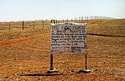
It is colloquially said that 'the outback' is located "beyond the Black Stump
Black Stump
The Australian expression black stump is the name for an imaginary point beyond which the country is considered remote or uncivilised, an abstract marker of the limits of established settlement. The origin of the expression, especially in its evolved use as an imaginary marker in the...
". The location of the black stump may be some hypothetical location or may vary depending on local custom and folklore. It has been suggested that the term comes from the Black Stump Wine Saloon that once stood about 10 kilometres out of Coolah, New South Wales
Coolah, New South Wales
Coolah is a town in the central northern part of New South Wales, Australia in Warrumbungle Shire. At the 2006 census, Coolah had a population of 798....
on the Gunnedah Road. It is claimed that the saloon, named after the nearby Black Stump Run and Black Stump Creek, was an important staging post for traffic to north-west New South Wales and it became a marker by which people gauged their journeys.
Bourke, New South Wales
-Transportation:Bourke can be reached by the Mitchell Highway, with additional sealed roads from town to the north , east and south . The town is also served by Bourke Airport and has Countrylink bus service to other regional centres, like Dubbo...
" although these terms are more frequently used when referring to something a long way from anywhere, or a long way away. The well-watered north of the continent is often called the "Top End
Top End
The Top End of northern Australia is the second northernmost point on the continent. It covers a rather vaguely-defined area of perhaps 400,000 square kilometres behind the northern coast from the Northern Territory capital of Darwin across to Arnhem Land with the Indian Ocean on the west, the...
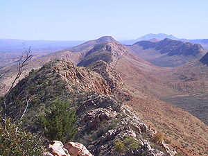
" and the arid interior "The Red Centre", owing to its vast amounts of red soil and sparse greenery amongst its landscape.
Wildlife
The Australian Outback is full of very well-adapted wildlife, although much of it may not be immediately visible to the casual observer. Many animals, such as kangarooKangaroo
A kangaroo is a marsupial from the family Macropodidae . In common use the term is used to describe the largest species from this family, especially those of the genus Macropus, Red Kangaroo, Antilopine Kangaroo, Eastern Grey Kangaroo and Western Grey Kangaroo. Kangaroos are endemic to the country...
s and dingo
Dingo
The Australian Dingo or Warrigal is a free-roaming wild dog unique to the continent of Australia, mainly found in the outback. Its original ancestors are thought to have arrived with humans from southeast Asia thousands of years ago, when dogs were still relatively undomesticated and closer to...
es, hide in bushes to rest and keep cool during the heat of the day.
Birdlife is prolific, most often seen at waterholes at dawn and dusk. Huge flocks of budgerigars, cockatoo
Cockatoo
A cockatoo is any of the 21 species belonging to the bird family Cacatuidae. Along with the Psittacidae and the Strigopidae , they make up the parrot order Psittaciformes . Placement of the cockatoos as a separate family is fairly undisputed, although many aspects of the other living lineages of...
s, corella
Corella
Corella may refer to:Ornithology* Corella , a member of a group of cockatoos from the subgenus Licmetis*Corella , the journal of the Australian Bird Study Association, formerly called Australian Bird Bander...
s and galah
Galah
The Galah , Eolophus roseicapilla, also known as the Rose-breasted Cockatoo, Galah Cockatoo, Roseate Cockatoo or Pink and Grey, is one of the most common and widespread cockatoos, and it can be found in open country in almost all parts of mainland Australia.It is endemic on the mainland and was...
s are often sighted. On bare ground or roads during the winter, various species of snakes and lizards bask in the sun, but they are rarely seen during the summer months.
Feral animals such as camels thrive in central Australia, brought to Australia by the early Afghan drivers
Afghan (Australia)
The Afghans or Ghans were camel drivers who worked in outback Australia from the 1860s to the 1930s. While called Afghans, not all of them were from Afghanistan; some came from the northern regions of British India, areas that now constitute modern-day Pakistan...
. Feral horses known as 'brumbies
Brumby
A Brumby is a free-roaming feral horse in Australia. Although found in many areas around the country, the best-known brumbies are found in the Australian Alps region in south-eastern Australia. Today, most of them are found in the Northern Territory, with the second largest population in Queensland...
' are station horses that have run wild. Feral pigs, foxes, cats and rabbits are also imported animals that degrade the environment, so time and money is spent eradicating them in an attempt to help protect fragile rangelands.
Tourism
- Alice Springs, Northern TerritoryAlice Springs, Northern TerritoryAlice Springs is the second largest town in the Northern Territory of Australia. Popularly known as "the Alice" or simply "Alice", Alice Springs is situated in the geographic centre of Australia near the southern border of the Northern Territory...
- Australian Stockman's Hall of FameAustralian Stockman's Hall of FameThe Australian Stockman's Hall of Fame is a museum located in Longreach, Queensland, Australia, which pays tribute to pioneers of the Australian outback...
- Birdsville, QueenslandBirdsville, Queensland-External links:*...
- Broken Hill, New South WalesBroken Hill, New South Wales-Geology:Broken Hill's massive orebody, which formed about 1,800 million years ago, has proved to be among the world's largest silver-lead-zinc mineral deposits. The orebody is shaped like a boomerang plunging into the earth at its ends and outcropping in the centre. The protruding tip of the...
- BroomeBroome, Western AustraliaBroome is a pearling and tourist town in the Kimberley region of Western Australia, north of Perth. The year round population is approximately 14,436, growing to more than 45,000 per month during the tourist season...
- Coober Pedy, South AustraliaCoober Pedy, South AustraliaCoober Pedy is a town in northern South Australia, 846 kilometres north of Adelaide on the Stuart Highway. According to the 2006 census, its population was 1,916 . The town is sometimes referred to as the "opal capital of the world" because of the quantity of precious opals that are mined there...
- Devils Marbles
- Kakadu National ParkKakadu National ParkKakadu National Park is in the Northern Territory of Australia, 171 km southeast of Darwin.Kakadu National Park is located within the Alligator Rivers Region of the Northern Territory of Australia. It covers an area of , extending nearly 200 kilometres from north to south and over 100 kilometres...
- Kalgoorlie-Boulder, Western Australia
- Kata TjutaKata TjutaKata Tjuta, sometimes written Tjuṯa , and also known as Mount Olga , are a group of large domed rock formations or bornhardts located about southwest of Alice Springs, in the southern part of the Northern Territory, central Australia...
(The Olgas) - Katherine GorgeNitmiluk National ParkNitmiluk National Park which is in the Northern Territory of Australia, 244 km southeast of Darwin, has been established around a series of gorges on the Katherine River and Edith Falls...
- Kings Canyon (Watarrka)
- MacDonnell RangesMacDonnell RangesThe MacDonnell Ranges of the Northern Territory, are a long series of mountain ranges located in the centre of Australia , and consist of parallel ridges running to the east and west of Alice Springs...
- Monkey MiaMonkey MiaMonkey Mia is a popular tourist resort located about 800 km north of Perth, Western Australia. The resort is 25 km northeast of the town of Denham in the Shark Bay Marine Park and World Heritage Site....
- Mount Isa, QueenslandMount Isa, Queensland-Culture and sport:The local theatre group, the Mount Isa Theatrical Society, or MITS, often holds plays and musicals, at least once every few months or so....
- Mount Augustus National ParkMount Augustus National ParkMount Augustus National Park is located 852 km north of Perth, 490 km by road east of Carnarvon and 390 km northwest of Meekatharra, in the Gascoyne region of Western Australia...
- Tennant Creek, Northern TerritoryTennant Creek, Northern TerritoryTennant Creek is a town located in the Northern Territory of Australia. It is the fifth largest town in the Northern Territory and it is located on the Stuart Highway, just south of the intersection with the western terminus of the Barkly Highway....
- Uluru (Ayers Rock)UluruUluru , also known as Ayers Rock, is a large sandstone rock formation in the southern part of the Northern Territory, central Australia. It lies south west of the nearest large town, Alice Springs; by road. Kata Tjuta and Uluru are the two major features of the Uluṟu-Kata Tjuṯa National Park....
- Willandra Lakes RegionWillandra Lakes RegionThe Willandra Lakes Region is a World Heritage Site that covers 2,400 square kilometres in south-western New South Wales, Australia.The Region contains important natural and cultural features including exceptional examples of past human civilization including the world's oldest cremation site...
Visitors to the outback often drive their own or rented vehicles, or take organized tours. Travel through remote areas on main roads is easily done and requires no planning. However travel through very remote areas, on isolated tracks, requires planning and a suitable, reliable vehicle (usually a four-wheel drive
Four-wheel drive
Four-wheel drive, 4WD, or 4×4 is a four-wheeled vehicle with a drivetrain that allows all four wheels to receive torque from the engine simultaneously...
). On very remote routes considerable supplies and equipment may be required, this can include prearranged caches. It is not advisable to travel into these especially remote areas with a single vehicle, unless fully equipped with good communication technology (e.g. a satellite phone, EPIRB etc.). Many visitors prefer to travel in these areas in a convoy. Deaths from tourists and locals becoming stranded on outback trips occasionally occur, sometime because insufficient water and food supplies were taken, or because people have walked away from their vehicle in search of help. Travellers through very remote areas should always inform a reliable person of their route and expected destination arrival time, and remember that a vehicle is much easier to locate in an aerial search, than a person, so in the event of a breakdown, they must not leave their vehicle.
Transport
The outback is criss-crossed by historic tracks. Most of the major highways have an excellent bitumen surface and other major roads are usually well-maintained dirt roads. Tracks in very sandy or exceedingly rocky areas may require high-clearance four wheel drives and spare fuel, tyres, food and water before attempting to travel them, however most outback roads are easily traversed in ordinary vehicles, provided care is taken. Drivers unused to dirt roads should be especially cautious – it is recommended that drivers reduce their speed, drive with extra care, and avoid driving at night because animals can stray on to roads. Travelling in remote areas in northern Australia is not advisable during the wet season (November to April), as heavy tropical downpours can quickly make dirt roads impassable. In the remotest parts of Australia fuel sellers are located hundreds of kilometres apart, so spare fuel must be carried or refuelling spots calculated carefully in order not to run out of fuel in between towns. In addition, multiple trailer trucks (known as Road Trains) traverse these roads and extreme care must be taken when around these vehicles, due to their weight, length (often three full trailers long) and amount of dust thrown up by 46+ tyres.The Stuart Highway
Stuart Highway
The Stuart Highway is one of Australia's major highways. It is a segment of Australia's Highway 1 extending from Darwin, Northern Territory, in the north, via Tennant Creek and Alice Springs, to Port Augusta, South Australia, in the south—a distance of...
runs from north to south through the centre of the continent, roughly paralleled by the Adelaide-Darwin railway
Adelaide-Darwin railway
The Adelaide–Darwin railway is a north-south transcontinental railway in Australia, between the cities of Adelaide, South Australia and Darwin, Northern Territory...
. There is a proposal to develop some of the roads running from the SW to the NE to create an all-weather road named the Outback Highway
Outback Highway
The Outback Highway or Outback Way is a series of roads and dirt tracks linking Winton, Queensland and Laverton, Western Australia. At , it crosses Central Australia , passing through; Queensland, the Northern Territory and Western Australia.It has been proposed as a development to provide an...
, crossing the continent diagonally from Laverton, Western Australia (north of Kalgoorlie
Kalgoorlie, Western Australia
Kalgoorlie, known as Kalgoorlie-Boulder, is a town in the Goldfields-Esperance region of Western Australia, and is located east-northeast of state capital Perth at the end of the Great Eastern Highway...
, through the Northern Territory to Winton
Winton, Queensland
-Qantas:Winton was one of the founding towns of the Australian airline Qantas. The first board meeting was held at the Winton Club on 10 February 1921.-Waltzing Matilda:...
, in Queensland.
Air transport is relied on for mail delivery in some areas, owing to sparse settlement and wet-season road closures. Most outback mines have an airstrip and many have a fly-in fly-out
Fly-in fly-out
Fly-in fly-out is a method of employing people in remote areas. It is often abbreviated to FIFO when referring to employment status. This is common in large mining states in Australia...
workforce. Most outback sheep station
Sheep station
A sheep station is a large property in Australia or New Zealand whose main activity is the raising of sheep for their wool and meat. In Australia, sheep stations are usually in the south-east or south-west of the country. In New Zealand the Merinos are usually in the high country of the South...
s and cattle station
Cattle station
Cattle station is an Australian term for a large farm , whose main activity is the rearing of cattle. In Australia, the owner of a cattle station is called a grazier...
s have an airstrip and quite a few have their own light plane. Medical and ambulance services are provided by the Royal Flying Doctor Service. The School of the Air
School of the Air
School of the Air is a generic term for correspondence schools catering for the primary and early secondary education of children in remote and outback Australia.-History:...
is a radio-based school using the RFDS radios.
- Birdsville TrackBirdsville TrackThe Birdsville Track is a notable outback road in Australia. The 517 km track runs from Marree, a small town in northern South Australia, north across the Tirari Desert and Sturt Stony Desert, ending in Birdsville in south western Queensland....
- Burke Developmental RoadBurke Developmental RoadThe Burke Developmental Road is a Queensland developmental road. It links Cloncurry and Normanton in a south–north direction, then continues to the east 30 km north from Normanton, till Dimbulah, where it becomes the Mareeba Dimbulah Road....
- Canning Stock RouteCanning Stock RouteThe Canning Stock Route is one of the toughest and most remote tracks in the world. It runs to Halls Creek from Wiluna, both in Western Australia. With a total distance of around it is also the longest historic stock route in the world...
- Colson Track
- Connie Sue HighwayConnie Sue HighwayThe Connie Sue Highway is an outback road that runs from Rawlinna on the Trans-Australian Railway to the Aboriginal community of Warburton on the Great Central Road. Approximately long and running north-south, it lies entirely in the state of Western Australia and crosses the Nullarbor Plain and...
- French LineSimpson DesertThe Simpson Desert is a large area of dry, red sandy plain and dunes in Northern Territory, South Australia and Queensland in central Australia. It is the fourth largest Australian desert, with an area of 176,500 km² ....
- Gary HighwayGary HighwayThe Gary Highway is a remote road in central Western Australia built by Len Beadell's Gunbarrel Road Construction Party in April and May 1963 and named after Beadell's son who was born earlier that year....
- Gibb River RoadGibb River RoadThe Gibb River Road is a former cattle route that stretches almost through The Kimberley between the Western Australian town of Derby and the Kununurra and Wyndham junction of the Great Northern Highway. Like its namesake, which does not actually cross the road but runs nearby at , it is named...
- Great Central RoadGreat Central RoadThe Great Central Road is a mostly unsealed Australian outback highway that runs 1126 km from Laverton, Western Australia to Yulara, Northern Territory ....
- Gunbarrel HighwayGunbarrel HighwayThe Gunbarrel Highway is an isolated desert track in the Northern Territory, South Australia and Western Australia. It consists of about of washaways, heavy corrugations, stone, sand and flood plains...
- K1 Line
- Kalumburu RoadKalumburu RoadKalumburu Road in the Kimberley Region of Western Australia is a 267 kilometre road that connects the Gibb River Road to the aboriginal community of Kalumburu on the coast via the Mitchell Plateau. The road, which often becomes inaccessible during the Wet season, is suitable for 4WD traffic and...
- Kidson Track
- Lasseter HighwayLasseter HighwayLasseter Highway is a fully sealed 244 kilometre highway in the Northern Territory of Australia. It connects Yulara, Kata Tjuta and Uluru east to the Stuart Highway...
- Oodnadatta TrackOodnadatta TrackThe Oodnadatta Track , Australia is an unsealed 620 kilometre track between Marree and Marla via Oodnadatta in South Australia. It passes the southern lake of the Lake Eyre National Park....
- Peninsula Developmental Road
- Plenty HighwayPlenty HighwayThe Plenty Highway is a 498 kilometre outback mostly unsealed track cutting across to north-western Queensland from the Stuart Highway.The track leaves the Stuart Highway 68 kilometres north of Alice Springs, follows the Sandover Highway for the first 27 kilometres and finishes in Tobermorey...
- Rig Road
- Sandover HighwaySandover HighwayThe Sandover Highway is an outback unsealed track cutting across to north-western Queensland from the Stuart Highway.Its total length is about 550 kilometres and it passes through semi-arid deserts and Spinifex blacksoil plains...
- Strzelecki TrackStrzelecki TrackThe Strzelecki Track is an outback track in South Australia, mostly unsealed but with a few short sealed sections to facilitate overtaking, linking Innamincka to Lyndhurst...
- Tallawana Track
- Tanami TrackTanami TrackThe Tanami Road, also known as the Tanami Track and the McGuire Track, is a road in northern Australia. It follows a cattle droving route northwest from the MacDonnell Ranges area of central Australia just north of Alice Springs to Halls Creek in the Kimberley.The Tanami Road is the most direct...
- WAA Line
See also
- Central AustraliaCentral AustraliaCentral Australia/Alice Springs Region is one of the five regions in the Northern Territory. The term Central Australia is used to describe an area centred on Alice Springs in Australia. It is sometimes referred to as Centralia; likewise the people of the area are sometimes called Centralians...
- Channel CountryChannel CountryThe Channel Country is region of outback Australia located mostly in the state of Queensland but also in portions of South Australia, Northern Territory and New South Wales. The name comes from the numerous intertwined rivulets that cross the region, which cover 150,000 km²...
- Australian outback literature of the 20th centuryAustralian outback literature of the 20th centuryThis article refers to the works of poets and novelists and specialized writers who have written about the Australian outback from first-hand experience. This is a wide and important field of study, particularly as it frequently addresses race relations in Australia, often from a non-political...
Further reading
- Dwyer Andrew (2007) Outback - Recipes and Stories from the Campfire Miegunyah Press ISBN 978 0 522 85380 3
- Read, Ian G.(1995) Australia's central and western outback : the driving guide Crows Nest, N.S.W. Little Hills Press. Little Hills Press explorer guides ISBN 1863150617
- Year of the Outback 2002, Western Australia Perth, W.A.
External links
- From this Broken Hill
- Beautiful Australian Outback - slideshow by Life magazine