
Geography of Sweden
Encyclopedia
| Sweden | |
| Continent Continent A continent is one of several very large landmasses on Earth. They are generally identified by convention rather than any strict criteria, with seven regions commonly regarded as continents—they are : Asia, Africa, North America, South America, Antarctica, Europe, and Australia.Plate tectonics is... |
Europe Europe Europe is, by convention, one of the world's seven continents. Comprising the westernmost peninsula of Eurasia, Europe is generally 'divided' from Asia to its east by the watershed divides of the Ural and Caucasus Mountains, the Ural River, the Caspian and Black Seas, and the waterways connecting... |
| Subregion Subregion A subregion is a conceptual unit which derives from a larger region or continent and is usually based on location. Cardinal directions, such as south or southern, are commonly used to define a subregion.- United Nations subregions :... |
Scandinavia Scandinavia Scandinavia is a cultural, historical and ethno-linguistic region in northern Europe that includes the three kingdoms of Denmark, Norway and Sweden, characterized by their common ethno-cultural heritage and language. Modern Norway and Sweden proper are situated on the Scandinavian Peninsula,... |
| Geographic coordinates | 62°00′N 15°00′E |
| Area Area Area is a quantity that expresses the extent of a two-dimensional surface or shape in the plane. Area can be understood as the amount of material with a given thickness that would be necessary to fashion a model of the shape, or the amount of paint necessary to cover the surface with a single coat... - total - water |
Ranked 56th 450,295 km² 39,960- km² (8.69%) |
| Coastline | 3,218 km (2,000 mi) |
| Land boundaries | 2,333 km (1,550 mi) |
| Countries bordered | Norway Norway Norway , officially the Kingdom of Norway, is a Nordic unitary constitutional monarchy whose territory comprises the western portion of the Scandinavian Peninsula, Jan Mayen, and the Arctic archipelago of Svalbard and Bouvet Island. Norway has a total area of and a population of about 4.9 million... 1,619 km Finland Finland Finland , officially the Republic of Finland, is a Nordic country situated in the Fennoscandian region of Northern Europe. It is bordered by Sweden in the west, Norway in the north and Russia in the east, while Estonia lies to its south across the Gulf of Finland.Around 5.4 million people reside... 614 km |
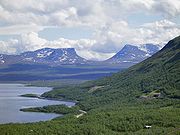
| Highest point | Kebnekaise Kebnekaise Kebnekaise is the highest mountain in Sweden and Sápmi. The Kebnekaise massif, which is part of the Scandinavian Mountains, has two peaks, of which the southern, glaciated one is highest at above sea level at the latest time of measurement. The north top is free of ice... , 2,111 m / 6,926 ft |
| Lowest point | Kristianstad Kristianstad Kristianstad is a city and the seat of Kristianstad Municipality, Skåne County, Sweden with 35,711 inhabitants in 2010.-History:The city was founded in 1614 by King Christian IV of Denmark, the city's name literally means 'Town of Christian', as a planned city after the burning of the town of Vä... , -2.41 m |
| Longest river | Klarälven Klarälven Klarälven is a river flowing through Norway and Sweden. Together with Göta älv, which it is called as the river has passed through the lake Vänern, thus regarded as an entity, Göta älv-Klarälven is the longest river in Scandinavia and in the Nordic countries and its Swedish part the longest river... -Göta älv Göta älv The Göta is a river that drains lake Vänern into the Kattegat at the city of Gothenburg on the western coast of Sweden. It is located in Götaland, with the river itself being a site of early Geatish settlement. The length is 93 km. Often the combination of Göta älv and Klarälven is mentioned... , 720 km (447.4 mi) |
| Largest inland body of water | Vänern Vänern Vänern is the largest lake in Sweden, the largest lake in the EU and the third largest lake in Europe after Ladoga and Onega in Russia. It is located in the provinces of Västergötland, Dalsland, and Värmland in the southwest of the country.- History :... 5,648 km² (3,510 sq mi) |
| Land use - Arable land - Permanent crops - Other |
5.93 % 0.01 % 94.06 % (2005 est.) |
| Irrigated land | 1,150 km² (2003) |
| Climate Climate Climate encompasses the statistics of temperature, humidity, atmospheric pressure, wind, rainfall, atmospheric particle count and other meteorological elemental measurements in a given region over long periods... : |
Temperate Temperate In geography, temperate or tepid latitudes of the globe lie between the tropics and the polar circles. The changes in these regions between summer and winter are generally relatively moderate, rather than extreme hot or cold... to subarctic Subarctic The Subarctic is a region in the Northern Hemisphere immediately south of the true Arctic and covering much of Alaska, Canada, the north of Scandinavia, Siberia, and northern Mongolia... |
| Terrain Terrain Terrain, or land relief, is the vertical and horizontal dimension of land surface. When relief is described underwater, the term bathymetry is used... : |
Flat lowland Lowland In physical geography, a lowland is any broad expanse of land with a general low level. The term is thus applied to the landward portion of the upward slope from oceanic depths to continental highlands, to a region of depression in the interior of a mountainous region, to a plain of denudation, or... s, mountain Mountain Image:Himalaya_annotated.jpg|thumb|right|The Himalayan mountain range with Mount Everestrect 58 14 160 49 Chomo Lonzorect 200 28 335 52 Makalurect 378 24 566 45 Mount Everestrect 188 581 920 656 Tibetan Plateaurect 250 406 340 427 Rong River... s |
| Natural resources | Iron Iron Iron is a chemical element with the symbol Fe and atomic number 26. It is a metal in the first transition series. It is the most common element forming the planet Earth as a whole, forming much of Earth's outer and inner core. It is the fourth most common element in the Earth's crust... ore, copper Copper Copper is a chemical element with the symbol Cu and atomic number 29. It is a ductile metal with very high thermal and electrical conductivity. Pure copper is soft and malleable; an exposed surface has a reddish-orange tarnish... , lead Lead Lead is a main-group element in the carbon group with the symbol Pb and atomic number 82. Lead is a soft, malleable poor metal. It is also counted as one of the heavy metals. Metallic lead has a bluish-white color after being freshly cut, but it soon tarnishes to a dull grayish color when exposed... , zinc Zinc Zinc , or spelter , is a metallic chemical element; it has the symbol Zn and atomic number 30. It is the first element in group 12 of the periodic table. Zinc is, in some respects, chemically similar to magnesium, because its ion is of similar size and its only common oxidation state is +2... , gold Gold Gold is a chemical element with the symbol Au and an atomic number of 79. Gold is a dense, soft, shiny, malleable and ductile metal. Pure gold has a bright yellow color and luster traditionally considered attractive, which it maintains without oxidizing in air or water. Chemically, gold is a... , silver Silver Silver is a metallic chemical element with the chemical symbol Ag and atomic number 47. A soft, white, lustrous transition metal, it has the highest electrical conductivity of any element and the highest thermal conductivity of any metal... , tungsten Tungsten Tungsten , also known as wolfram , is a chemical element with the chemical symbol W and atomic number 74.A hard, rare metal under standard conditions when uncombined, tungsten is found naturally on Earth only in chemical compounds. It was identified as a new element in 1781, and first isolated as... , uranium Uranium Uranium is a silvery-white metallic chemical element in the actinide series of the periodic table, with atomic number 92. It is assigned the chemical symbol U. A uranium atom has 92 protons and 92 electrons, of which 6 are valence electrons... , arsenic Arsenic Arsenic is a chemical element with the symbol As, atomic number 33 and relative atomic mass 74.92. Arsenic occurs in many minerals, usually in conjunction with sulfur and metals, and also as a pure elemental crystal. It was first documented by Albertus Magnus in 1250.Arsenic is a metalloid... , feldspar Feldspar Feldspars are a group of rock-forming tectosilicate minerals which make up as much as 60% of the Earth's crust.... , timber Timber Timber may refer to:* Timber, a term common in the United Kingdom and Australia for wood materials * Timber, Oregon, an unincorporated community in the U.S... , hydropower Hydropower Hydropower, hydraulic power, hydrokinetic power or water power is power that is derived from the force or energy of falling water, which may be harnessed for useful purposes. Since ancient times, hydropower has been used for irrigation and the operation of various mechanical devices, such as... |
| Natural hazards | Ice Ice Ice is water frozen into the solid state. Usually ice is the phase known as ice Ih, which is the most abundant of the varying solid phases on the Earth's surface. It can appear transparent or opaque bluish-white color, depending on the presence of impurities or air inclusions... flow |
| Environmental issues | Acid rain Acid rain Acid rain is a rain or any other form of precipitation that is unusually acidic, meaning that it possesses elevated levels of hydrogen ions . It can have harmful effects on plants, aquatic animals, and infrastructure. Acid rain is caused by emissions of carbon dioxide, sulfur dioxide and nitrogen... s, eutrophication Eutrophication Eutrophication or more precisely hypertrophication, is the movement of a body of water′s trophic status in the direction of increasing plant biomass, by the addition of artificial or natural substances, such as nitrates and phosphates, through fertilizers or sewage, to an aquatic system... |
Sweden
Sweden
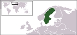
Sweden , officially the Kingdom of Sweden , is a Nordic country on the Scandinavian Peninsula in Northern Europe. Sweden borders with Norway and Finland and is connected to Denmark by a bridge-tunnel across the Öresund....
is a country in Northern Europe
Northern Europe
Northern Europe is the northern part or region of Europe. Northern Europe typically refers to the seven countries in the northern part of the European subcontinent which includes Denmark, Estonia, Latvia, Lithuania, Norway, Finland and Sweden...
on the Scandinavia
Scandinavia
Scandinavia is a cultural, historical and ethno-linguistic region in northern Europe that includes the three kingdoms of Denmark, Norway and Sweden, characterized by their common ethno-cultural heritage and language. Modern Norway and Sweden proper are situated on the Scandinavian Peninsula,...
n Peninsula. Its borders are Norway
Norway
Norway , officially the Kingdom of Norway, is a Nordic unitary constitutional monarchy whose territory comprises the western portion of the Scandinavian Peninsula, Jan Mayen, and the Arctic archipelago of Svalbard and Bouvet Island. Norway has a total area of and a population of about 4.9 million...
to the west; Finland
Finland
Finland , officially the Republic of Finland, is a Nordic country situated in the Fennoscandian region of Northern Europe. It is bordered by Sweden in the west, Norway in the north and Russia in the east, while Estonia lies to its south across the Gulf of Finland.Around 5.4 million people reside...
to the northeast; and the Baltic Sea
Baltic Sea
The Baltic Sea is a brackish mediterranean sea located in Northern Europe, from 53°N to 66°N latitude and from 20°E to 26°E longitude. It is bounded by the Scandinavian Peninsula, the mainland of Europe, and the Danish islands. It drains into the Kattegat by way of the Øresund, the Great Belt and...
and Gulf of Bothnia
Gulf of Bothnia
The Gulf of Bothnia is the northernmost arm of the Baltic Sea. It is situated between Finland's west coast and Sweden's east coast. In the south of the gulf lie the Åland Islands, between the Sea of Åland and the Archipelago Sea.-Name:...
to the east and south.
Sweden has a long coastline on the eastern side and the Scandinavian mountain chain (Skanderna) on the western border, a range that separates Sweden from Norway. It has maritime borders with Denmark
Denmark
Denmark is a Scandinavian country in Northern Europe. The countries of Denmark and Greenland, as well as the Faroe Islands, constitute the Kingdom of Denmark . It is the southernmost of the Nordic countries, southwest of Sweden and south of Norway, and bordered to the south by Germany. Denmark...
, Germany
Germany
Germany , officially the Federal Republic of Germany , is a federal parliamentary republic in Europe. The country consists of 16 states while the capital and largest city is Berlin. Germany covers an area of 357,021 km2 and has a largely temperate seasonal climate...
, Poland
Poland
Poland , officially the Republic of Poland , is a country in Central Europe bordered by Germany to the west; the Czech Republic and Slovakia to the south; Ukraine, Belarus and Lithuania to the east; and the Baltic Sea and Kaliningrad Oblast, a Russian exclave, to the north...
, Russia
Russia
Russia or , officially known as both Russia and the Russian Federation , is a country in northern Eurasia. It is a federal semi-presidential republic, comprising 83 federal subjects...
, Lithuania
Lithuania
Lithuania , officially the Republic of Lithuania is a country in Northern Europe, the biggest of the three Baltic states. It is situated along the southeastern shore of the Baltic Sea, whereby to the west lie Sweden and Denmark...
, Latvia
Latvia
Latvia , officially the Republic of Latvia , is a country in the Baltic region of Northern Europe. It is bordered to the north by Estonia , to the south by Lithuania , to the east by the Russian Federation , to the southeast by Belarus and shares maritime borders to the west with Sweden...
and Estonia
Estonia
Estonia , officially the Republic of Estonia , is a state in the Baltic region of Northern Europe. It is bordered to the north by the Gulf of Finland, to the west by the Baltic Sea, to the south by Latvia , and to the east by Lake Peipsi and the Russian Federation . Across the Baltic Sea lies...
, and it is also linked to Denmark
Denmark
Denmark is a Scandinavian country in Northern Europe. The countries of Denmark and Greenland, as well as the Faroe Islands, constitute the Kingdom of Denmark . It is the southernmost of the Nordic countries, southwest of Sweden and south of Norway, and bordered to the south by Germany. Denmark...
(southwest) by the Öresund Bridge
Oresund Bridge
The Øresund or Öresund Bridge is a combined twin-track railway and dual carriageway bridge-tunnel across the Øresund strait.The bridge connects Sweden and Denmark, and it is the longest road and rail bridge in Europe. The Øresund Bridge also connects two major Metropolitan Areas: those of the...
.
At 450295 km² (173,860 sq mi), Sweden is the 55th largest country in the world. It is the 5th largest in Europe and the largest in Northern Europe.
Terrain
.png)
Arctic Circle
The Arctic Circle is one of the five major circles of latitude that mark maps of the Earth. For Epoch 2011, it is the parallel of latitude that runs north of the Equator....
.
The lowest elevation in Sweden is in the bay of Lake Hammarsjön, near Kristianstad
Kristianstad
Kristianstad is a city and the seat of Kristianstad Municipality, Skåne County, Sweden with 35,711 inhabitants in 2010.-History:The city was founded in 1614 by King Christian IV of Denmark, the city's name literally means 'Town of Christian', as a planned city after the burning of the town of Vä...
at
-2.41 m below sea level. The highest point is Kebnekaise
Kebnekaise
Kebnekaise is the highest mountain in Sweden and Sápmi. The Kebnekaise massif, which is part of the Scandinavian Mountains, has two peaks, of which the southern, glaciated one is highest at above sea level at the latest time of measurement. The north top is free of ice...
at 2111 m (6,926 ft) above sea level.
The highest population density is in the Öresund
Oresund
The Sound , is the strait that separates the Danish island Zealand from the southern Swedish province of Scania. Its width is just at the narrowest point between Helsingør, Denmark, and Helsingborg, Sweden...
region in southern Sweden and in the valley of lake Mälaren
Mälaren
Lake Mälaren is the third-largest lake in Sweden, after Lakes Vänern and Vättern. Its area is 1,140 km² and its greatest depth is 64 m. Mälaren spans 120 kilometers from east to west...
near to Stockholm. Gotland
Gotland
Gotland is a county, province, municipality and diocese of Sweden; it is Sweden's largest island and the largest island in the Baltic Sea. At 3,140 square kilometers in area, the region makes up less than one percent of Sweden's total land area...
and Öland
Öland
' is the second largest Swedish island and the smallest of the traditional provinces of Sweden. Öland has an area of 1,342 km² and is located in the Baltic Sea just off the coast of Småland. The island has 25,000 inhabitants, but during Swedish Midsummer it is visited by up to 500,000 people...
are Sweden's largest islands; Vänern
Vänern
Vänern is the largest lake in Sweden, the largest lake in the EU and the third largest lake in Europe after Ladoga and Onega in Russia. It is located in the provinces of Västergötland, Dalsland, and Värmland in the southwest of the country.- History :...
and Vättern
Vättern
Vättern is the second largest lake in Sweden, after Lake Vänern and the sixth largest lake in Europe. It is a long, finger-shaped body of fresh water in south central Sweden to the southeast of Vänern pointing at the tip of Scandinavia....
are its largest lakes. Vänern is the third largest in Europe, after Lake Ladoga
Lake Ladoga
Lake Ladoga is a freshwater lake located in the Republic of Karelia and Leningrad Oblast in northwestern Russia, not far from Saint Petersburg. It is the largest lake in Europe, and the 14th largest lake by area in the world.-Geography:...
and Lake Onega
Lake Onega
Lake Onega is a lake in the north-west European part of Russia, located on the territory of Republic of Karelia, Leningrad Oblast and Vologda Oblast. It belongs to the basin of Baltic Sea, Atlantic Ocean, and is the second largest lake in Europe after Lake Ladoga...
in Russia.
Sweden consists of 39,960 km² of water area, constituting around 95,700 lakes. The lakes are sometimes used for water power plants, especially the large northern rivers and lakes. The two largest islands are Gotland
Gotland
Gotland is a county, province, municipality and diocese of Sweden; it is Sweden's largest island and the largest island in the Baltic Sea. At 3,140 square kilometers in area, the region makes up less than one percent of Sweden's total land area...
and Öland
Öland
' is the second largest Swedish island and the smallest of the traditional provinces of Sweden. Öland has an area of 1,342 km² and is located in the Baltic Sea just off the coast of Småland. The island has 25,000 inhabitants, but during Swedish Midsummer it is visited by up to 500,000 people...
in the southeast. They each have their own culture, most notably Gotland with the old, largely intact and heritage-filled city Visby
Visby
-See also:* Battle of Visby* Gotland University College* List of governors of Gotland County-External links:* - Visby*...
.
Provinces
Sweden has 25 provinceProvince
A province is a territorial unit, almost always an administrative division, within a country or state.-Etymology:The English word "province" is attested since about 1330 and derives from the 13th-century Old French "province," which itself comes from the Latin word "provincia," which referred to...
s or landskap (landscapes), based on culture, geography and history: Bohuslän
Bohuslän
' is a Swedish traditional province, or landskap, situated in Götaland on the northernmost part of the country's west coast. It is bordered by Dalsland to the northeast, Västergötland to the southeast, the Skagerrak arm of the North Sea to the west, and the county of Østfold in Norway to the north...
, Blekinge
Blekinge
' is one of the traditional provinces of Sweden , situated in the south of the country. It borders Småland, Scania and the Baltic Sea.The name "Blekinge" comes from the adjective bleke, which corresponds to the nautical term for "dead calm"....
, Dalarna
Dalarna
', English exonym: Dalecarlia, is a historical province or landskap in central Sweden. Another English language form established in literature is the Dales. Places involving the element Dalecarlia exist in the United States....
, Dalsland
Dalsland
Dalsland is a Swedish traditional province, or landskap, situated in Götaland in southern Sweden. Lying to the west of Lake Vänern, it is bordered by Värmland to the north, Västergötland to the southeast, Bohuslän to the west, and Norway to the northwest....
, Gotland
Gotland
Gotland is a county, province, municipality and diocese of Sweden; it is Sweden's largest island and the largest island in the Baltic Sea. At 3,140 square kilometers in area, the region makes up less than one percent of Sweden's total land area...
, Gästrikland
Gästrikland
' is a historical province or landskap on the eastern coast of Sweden. It borders Uppland, Västmanland, Dalarna, Hälsingland and the Gulf of Bothnia. Gästrikland is the southernmost of the Norrland provinces....
, Halland
Halland
' is one of the traditional provinces of Sweden , on the western coast of Sweden. It borders Västergötland, Småland, Scania and the sea of Kattegat.-Administration:...
, Hälsingland
Hälsingland
' is a historical province or landskap in central Sweden. It borders to Gästrikland, Dalarna, Härjedalen, Medelpad and to the Gulf of Bothnia...
, Härjedalen
Härjedalen
' is a historical province or landskap in the centre of Sweden. It borders the country of Norway as well as the provinces of Dalarna, Hälsingland, Medelpad, and Jämtland...
, Jämtland
Jämtland
Jämtland or Jamtland is a historical province or landskap in the center of Sweden in northern Europe. It borders to Härjedalen and Medelpad in the south, Ångermanland in the east, Lapland in the north and Trøndelag and Norway in the west...
, Lapland, Medelpad
Medelpad
' is a historical province or landskap in the north of Sweden. It borders to Hälsingland, Härjedalen, Jämtland, Ångermanland and the Gulf of Bothnia....
, Norrbotten
Norrbotten
Norrbotten is a Swedish province in northernmost Sweden. It borders south to Västerbotten, west to Swedish Lapland, and east to Finland.- Administration :...
, Närke
Närke
' is a Swedish traditional province, or landskap, situated in Svealand in south central Sweden. It is bordered by Västmanland to the north, Södermanland to the east, Östergötland to the southeast, Västergötland to the southwest, and Värmland to the northwest...
, Skåne
Scania
Scania is the southernmost of the 25 traditional non-administrative provinces of Sweden, constituting a peninsula on the southern tip of the Scandinavian peninsula, and some adjacent islands. The modern administrative subdivision Skåne County is almost, but not totally, congruent with the...
, Småland
Småland
' is a historical province in southern Sweden.Småland borders Blekinge, Scania or Skåne, Halland, Västergötland, Östergötland and the island Öland in the Baltic Sea. The name Småland literally means Small Lands. . The latinized form Smolandia has been used in other languages...
, Södermanland
Södermanland
', sometimes referred to under its Latin form Sudermannia or Sudermania, is a historical province or landskap on the south eastern coast of Sweden. It borders Östergötland, Närke, Västmanland and Uppland. It is also bounded by lake Mälaren and the Baltic sea.In Swedish, the province name is...
, Uppland
Uppland
Uppland is a historical province or landskap on the eastern coast of Sweden, just north of Stockholm, the capital. It borders Södermanland, Västmanland and Gästrikland. It is also bounded by lake Mälaren and the Baltic sea...
, Värmland
Värmland
' is a historical province or landskap in the west of middle Sweden. It borders Västergötland, Dalsland, Dalarna, Västmanland and Närke. It is also bounded by Norway in the west. Latin name versions are Vermelandia and Wermelandia. Although the province's land originally was Götaland, the...
, Västmanland
Västmanland
' is a historical Swedish province, or landskap, in middle Sweden. It borders Södermanland, Närke, Värmland, Dalarna and Uppland.The name comes from "West men", referring to the people west of Uppland, the core province of early Sweden.- Administration :...
, Västerbotten
Västerbotten
', English exonym: West Bothnia, is a province or landskap in the north of Sweden. It borders Ångermanland, Lapland, Norrbotten and the Gulf of Bothnia. It is famous for the cheese with the same name as the province.- Administration :...
, Västergötland
Västergötland
', English exonym: West Gothland, is one of the 25 traditional non-administrative provinces of Sweden , situated in the southwest of Sweden. In older English literature one may also encounter the Latinized version Westrogothia....
, Ångermanland
Ångermanland
' is a historical province or landskap in the north of Sweden. It borders to Medelpad, Jämtland, Lapland, Västerbotten and the Gulf of Bothnia. The name "Ångermanland" comes from the Old Norse "anger", which means "deep fjord" and refers to the deep mouth of the river Ångermanälven...
, Öland
Öland
' is the second largest Swedish island and the smallest of the traditional provinces of Sweden. Öland has an area of 1,342 km² and is located in the Baltic Sea just off the coast of Småland. The island has 25,000 inhabitants, but during Swedish Midsummer it is visited by up to 500,000 people...
and Östergötland
Östergötland
Östergötland, English exonym: East Gothland, is one of the traditional provinces of Sweden in the south of Sweden. It borders Småland, Västergötland, Närke, Södermanland, and the Baltic Sea. In older English literature, one might also encounter the Latinized version, Ostrogothia...
.
While these provinces serve no political or administrative purpose, they play an important role for people's self-identification. The provinces are usually grouped together in three large lands (landsdelar): the northern Norrland
Norrland
Norrland is one of the three lands of Sweden , the northern part, consisting of nine provinces. The term Norrland is not used for any administrative purpose, but it is common in everyday language, e.g...
, the central Svealand
Svealand
Svealand , Swealand or Sweden proper is the historical core region of Sweden. It is located in south central Sweden and is one of three lands of Sweden, bounded to the north by Norrland and to the south by Götaland. Deep forests, Tiveden, Tylöskog, Kolmården, separated Svealand from Götaland...
and southern Götaland
Götaland
Götaland , Gothia, Gothland, Gothenland, Gautland or Geatland is one of three lands of Sweden and comprises provinces...
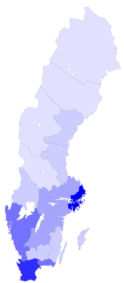
. The sparsely populated Norrland encompasses almost 60% of the country.
Counties
County
A county is a jurisdiction of local government in certain modern nations. Historically in mainland Europe, the original French term, comté, and its equivalents in other languages denoted a jurisdiction under the sovereignty of a count A county is a jurisdiction of local government in certain...
or län. In each county there is a County Administrative Board
County Administrative Boards of Sweden
A County Administrative Board is a Government appointed board of a County in Sweden. It is led by a Governor or Landshövding appointed for a term of six years and the list of succession, in most cases, stretches back to 1634 when the counties were created...
or länsstyrelse which is appointed by the government.
In each county there is also a separate County Council
County Councils of Sweden
A county council, or landsting, is an elected assembly of a county in Sweden. A county council is a political entity, elected by the county electorate and typically its main responsibilities lie within the public health care system. In each county there is also a county administrative board which...
or landsting, which is the municipal representation appointed by the county electorate.
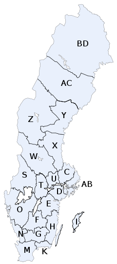
- K = Blekinge CountyBlekinge CountyBlekinge County is a county or län in the south of Sweden. It borders the Counties of Skåne, Kronoberg, Kalmar and the Baltic Sea. The capital is Karlskrona...
- W = Dalarna CountyDalarna CountyDalarna County is a county or län in middle Sweden. It borders the counties of Jämtland, Gävleborg, Västmanland, Örebro and Värmland. It is also bordered by the Norwegian counties of Hedmark and Sør-Trøndelag in the west...
- I = Gotland CountyGotland CountyGotland County is a county or län of Sweden. Gotland is located in the Baltic Sea to the east of Öland, and is the largest of Sweden's islands. Counties are usually sub-divided into municipalities, but Gotland County only consists of one municipality: Gotland Municipality. Gotland County at...
- X = Gävleborg CountyGävleborg CountyGävleborg County is a county or län on the Baltic Sea coast of Sweden. It borders to the counties of Uppsala, Västmanland, Dalarna, Jämtland and Västernorrland. The capital is Gävle.- Administration :...
- N = Halland CountyHalland CountyHalland County is a county on the western coast of Sweden. It corresponds roughly to the cultural and historical province of Halland. The capital is Halmstad....
- Z = Jämtland CountyJämtland CountyJämtland County is a county or län in the middle of Sweden consisting of the provinces of Jämtland and Härjedalen, along with minor parts of Hälsingland and Ångermanland, plus two tiny uninhabited strips of Lapland and Dalarna. Jämtland County constitutes 12 percent of Sweden's total area, and is...
- F = Jönköping CountyJönköping CountyJönköping County is a county or län in southern Sweden. It borders the counties of Halland, Västra Götaland, Östergötland, Kalmar and Kronoberg. The capital is Jönköping.- Provinces :...
- H = Kalmar CountyKalmar CountyKalmar County is a county or län in southern Sweden. It borders the counties of Kronoberg, Jönköping, Blekinge and Östergötland. To the east in the Baltic Sea is the island Gotland....
- G = Kronoberg CountyKronoberg CountyKronoberg County is a County or län in southern Sweden. It borders the counties of Skåne, Halland, Jönköping, Kalmar and Blekinge. Its capital is the city Växjö.- Province :For History, Geography and Culture see: Småland...
- BD = Norrbotten CountyNorrbotten CountyNorrbotten County is the northernmost county or län of Sweden. It borders Västerbotten County to the southwest, the Gulf of Bothnia to the southeast. It also borders the counties of Nordland and Troms in Norway to the northwest, and Lapland Province in Finland to the northeast.The name...
- M = Skåne CountySkåne CountySkåne County is the southernmost administrative county or län, of Sweden, basically corresponding to the historical province Scania. It borders the counties of Halland, Kronoberg and Blekinge. The seat of residence for the Skåne Governor is the town of Malmö...
- AB = Stockholm CountyStockholm CountyStockholm County is a county or län on the Baltic sea coast of Sweden. It borders Uppsala County and Södermanland County. It also borders Mälaren and the Baltic Sea. The city of Stockholm is the capital of Sweden. Stockholm County is divided by the historic provinces of Uppland and Södermanland...
- D = Södermanland CountySödermanland CountySödermanland County is a county or län on the south east coast of Sweden. It borders the counties of Östergötland, Örebro, Västmanland, Uppsala, Stockholm and to the Baltic sea....
- C = Uppsala CountyUppsala CountyUppsala County is a county or län on the eastern coast of Sweden. It borders the counties of Stockholm, Södermanland, Västmanland, Gävleborg, and the Baltic Sea.- Province :For History, Geography and Culture see: Uppland...
- S = Värmland CountyVärmland CountyVärmland County is a county or län in west central Sweden. It borders the Swedish counties of Dalarna, Örebro and Västra Götaland, as well as the Norwegian counties of Østfold, Akershus and Hedmark to the west.- Province :...
- AC = Västerbotten CountyVästerbotten CountyVästerbotten County is a county or län in the north of Sweden. It borders the counties of Västernorrland, Jämtland, and Norrbotten, as well as the Norwegian county of Nordland and the Gulf of Bothnia.- Provinces :...
- Y = Västernorrland CountyVästernorrland CountyVästernorrland County is a county or län in the north of Sweden. It is bordered by the counties of Gävleborg, Jämtland, Västerbotten and the Gulf of Bothnia.- Province :...
- U = Västmanland CountyVästmanland CountyVästmanland County is a county or län in central Sweden. It borders to the counties of Södermanland, Örebro, Gävleborg, Dalarna and Uppsala...
- O = Västra Götaland CountyVästra Götaland CountyVästra Götaland County is a county or län on the western coast of Sweden.The county is the second largest of Sweden's counties and it is subdivided into 49 municipalities . Its population of 1,550,000 amounts to 17% of Sweden's population...
- T = Örebro CountyÖrebro CountyÖrebro County is a county or län in central Sweden. It borders the counties of Västra Götaland, Värmland, Dalarna, Västmanland, Södermanland and Östergötland.- Province :...
- E = Östergötland CountyÖstergötland CountyÖstergötland County is a county or län in southeastern Sweden. It borders the counties of Kalmar to the southeast, Jönköping to the southwest, Västra Götaland to the west, Örebro to the northwest, Södermanland to the northeast, and the Baltic Sea to the east.Östergötland County has a population of...
The letters shown were on the vehicle registration plate
Vehicle registration plate
A vehicle registration plate is a metal or plastic plate attached to a motor vehicle or trailer for official identification purposes. The registration identifier is a numeric or alphanumeric code that uniquely identifies the vehicle within the issuing region's database...
s until 1973 .
Municipalities
Gotland County
Gotland County is a county or län of Sweden. Gotland is located in the Baltic Sea to the east of Öland, and is the largest of Sweden's islands. Counties are usually sub-divided into municipalities, but Gotland County only consists of one municipality: Gotland Municipality. Gotland County at...
) to forty-nine (in Västra Götaland County
Västra Götaland County
Västra Götaland County is a county or län on the western coast of Sweden.The county is the second largest of Sweden's counties and it is subdivided into 49 municipalities . Its population of 1,550,000 amounts to 17% of Sweden's population...
). The total number of municipalities is 290.
The northern municipalities are often large in size, but have small populations – the largest municipality is Kiruna
Kiruna
Kiruna is the northernmost city in Sweden, situated in Lapland province, with 18,154 inhabitants in 2005. It is the seat of Kiruna Municipality Kiruna (Northern Sami: Giron, Finnish: Kiiruna) is the northernmost city in Sweden, situated in Lapland province, with 18,154 inhabitants in 2005. It is...
with an area as large as the three southern provinces in Sweden (Scania
Scania
Scania is the southernmost of the 25 traditional non-administrative provinces of Sweden, constituting a peninsula on the southern tip of the Scandinavian peninsula, and some adjacent islands. The modern administrative subdivision Skåne County is almost, but not totally, congruent with the...
, Blekinge
Blekinge
' is one of the traditional provinces of Sweden , situated in the south of the country. It borders Småland, Scania and the Baltic Sea.The name "Blekinge" comes from the adjective bleke, which corresponds to the nautical term for "dead calm"....
and Halland
Halland
' is one of the traditional provinces of Sweden , on the western coast of Sweden. It borders Västergötland, Småland, Scania and the sea of Kattegat.-Administration:...
) combined, but it only has a population of 25,000, and its density is about 1 / km².
Population
Sweden has a population of about 9 million. The north is less populated than the southern and central parts, mostly because of its colder climate.Cities
Cities and towns in Sweden are not political or administrative entities but localities or urban areaUrban areas in Sweden
Urban area is a common English translation of the Swedish term tätort. The official term in English, used by Statistics Sweden, is, however, locality. There are 1,940 localities in Sweden . They could be compared with census-designated places in the United States.A tätort in Sweden has a minimum of...
s, independent of the municipal subdivision.
The largest city, in terms of population, is the capital Stockholm
Stockholm urban area
The Stockholm urban area is the largest and most populous of the statistical localities or urban areas in Sweden. It has no administrative function of its own, but constitutes a continuous multimunicipal built-up area, which extends into 11 municipalities in Stockholm County. It contains the...
, in the east, the dominant city for culture and media, with a population of 1,250,000. The second largest city is Gothenburg
Gothenburg urban area
Gothenburg urban area is the second largest of the 1,940 localities or urban areas in Sweden. As such it has no administrative or political significance, but is a geographical and statistical entity...
, with 510,500, in the west. The third largest is Malmö
Malmö urban area
The Malmö Urban Area is the third largest of the 1,940 localities or urban areas of Sweden. As such it has no political or administrative significance, but is a geographical and statistical entity. It is not the same as Metropolitan Malmö , which is a much larger area.It is a bimunicipal locality...
in the south, with 258,000. The largest city in the north is Umeå
Umeå
- Transport :The road infrastructure in Umeå is well-developed, with two European highways passing through the city. About 4 km from the city centre is the Umeå City Airport...
with 76,000 inhabitants.
Natural resources
Sweden's natural resourcesNatural Resources
Natural Resources is a soul album released by Motown girl group Martha Reeves and the Vandellas in 1970 on the Gordy label. The album is significant for the Vietnam War ballad "I Should Be Proud" and the slow jam, "Love Guess Who"...
include copper
Copper
Copper is a chemical element with the symbol Cu and atomic number 29. It is a ductile metal with very high thermal and electrical conductivity. Pure copper is soft and malleable; an exposed surface has a reddish-orange tarnish...
, gold
Gold
Gold is a chemical element with the symbol Au and an atomic number of 79. Gold is a dense, soft, shiny, malleable and ductile metal. Pure gold has a bright yellow color and luster traditionally considered attractive, which it maintains without oxidizing in air or water. Chemically, gold is a...
, hydropower
Hydropower
Hydropower, hydraulic power, hydrokinetic power or water power is power that is derived from the force or energy of falling water, which may be harnessed for useful purposes. Since ancient times, hydropower has been used for irrigation and the operation of various mechanical devices, such as...
, iron ore, lead
Lead
Lead is a main-group element in the carbon group with the symbol Pb and atomic number 82. Lead is a soft, malleable poor metal. It is also counted as one of the heavy metals. Metallic lead has a bluish-white color after being freshly cut, but it soon tarnishes to a dull grayish color when exposed...
, silver
Silver
Silver is a metallic chemical element with the chemical symbol Ag and atomic number 47. A soft, white, lustrous transition metal, it has the highest electrical conductivity of any element and the highest thermal conductivity of any metal...
, timber
Timber
Timber may refer to:* Timber, a term common in the United Kingdom and Australia for wood materials * Timber, Oregon, an unincorporated community in the U.S...
, uranium
Uranium
Uranium is a silvery-white metallic chemical element in the actinide series of the periodic table, with atomic number 92. It is assigned the chemical symbol U. A uranium atom has 92 protons and 92 electrons, of which 6 are valence electrons...
, and zinc
Zinc
Zinc , or spelter , is a metallic chemical element; it has the symbol Zn and atomic number 30. It is the first element in group 12 of the periodic table. Zinc is, in some respects, chemically similar to magnesium, because its ion is of similar size and its only common oxidation state is +2...
.
Environment
Acid rainAcid rain
Acid rain is a rain or any other form of precipitation that is unusually acidic, meaning that it possesses elevated levels of hydrogen ions . It can have harmful effects on plants, aquatic animals, and infrastructure. Acid rain is caused by emissions of carbon dioxide, sulfur dioxide and nitrogen...
has become an issue because it is damaging soil
Soil
Soil is a natural body consisting of layers of mineral constituents of variable thicknesses, which differ from the parent materials in their morphological, physical, chemical, and mineralogical characteristics...
s and lake
Lake
A lake is a body of relatively still fresh or salt water of considerable size, localized in a basin, that is surrounded by land. Lakes are inland and not part of the ocean and therefore are distinct from lagoons, and are larger and deeper than ponds. Lakes can be contrasted with rivers or streams,...
s and polluting the North Sea
North Sea
In the southwest, beyond the Straits of Dover, the North Sea becomes the English Channel connecting to the Atlantic Ocean. In the east, it connects to the Baltic Sea via the Skagerrak and Kattegat, narrow straits that separate Denmark from Norway and Sweden respectively...
and the Baltic Sea
Baltic Sea
The Baltic Sea is a brackish mediterranean sea located in Northern Europe, from 53°N to 66°N latitude and from 20°E to 26°E longitude. It is bounded by the Scandinavian Peninsula, the mainland of Europe, and the Danish islands. It drains into the Kattegat by way of the Øresund, the Great Belt and...
. The HBV hydrology transport model has been used to analyze nutrient discharge to the Baltic from tributary watersheds.
Extreme points
The extreme points of Sweden include the coordinates that are farthest north, south, east and west in SwedenSweden
Sweden , officially the Kingdom of Sweden , is a Nordic country on the Scandinavian Peninsula in Northern Europe. Sweden borders with Norway and Finland and is connected to Denmark by a bridge-tunnel across the Öresund....
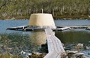
, and the ones that are at the highest and the lowest elevations in the country. The northern-most point in Sweden is Treriksröset
Treriksröset
Treriksröset , Treriksrøysa , Kolmen valtakunnan rajapyykki is the point at which the borders of Sweden, Norway and Finland meet....
, where the borders of Sweden, Norway
Norway
Norway , officially the Kingdom of Norway, is a Nordic unitary constitutional monarchy whose territory comprises the western portion of the Scandinavian Peninsula, Jan Mayen, and the Arctic archipelago of Svalbard and Bouvet Island. Norway has a total area of and a population of about 4.9 million...
, and Finland
Finland
Finland , officially the Republic of Finland, is a Nordic country situated in the Fennoscandian region of Northern Europe. It is bordered by Sweden in the west, Norway in the north and Russia in the east, while Estonia lies to its south across the Gulf of Finland.Around 5.4 million people reside...
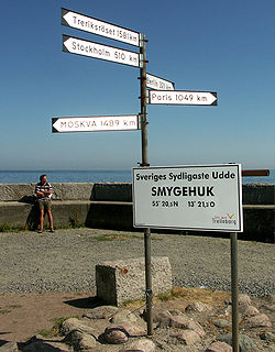
meet. The southern-most point is Smygehuk
Smygehuk
Smygehuk is a harbour and fishing village near Trelleborg in Skåne, Sweden. It's most known for being the southernmost point of Sweden and the Scandinavian Peninsula . To the west of the harbour is Smygehuk Lighthouse and Smygehuk Hostel....
; the western-most is Stora Drammen
Stora Drammen
Stora Drammen is the westernmost point of Sweden. It is an islet northwest of Kosteröarna, off Strömstad in Bohuslän. Its location is ....
, and the eastern-most is Kataja
Kataja
Kataja, the easternmost point of Sweden, is an islet south of Haparanda in Norrbotten. The islet's area is 0.71 km², about 2 km long and 200–500 m wide. Its location is .The island is divided between Sweden and Finland...
. The highest point in Sweden is Kebnekaise
Kebnekaise
Kebnekaise is the highest mountain in Sweden and Sápmi. The Kebnekaise massif, which is part of the Scandinavian Mountains, has two peaks, of which the southern, glaciated one is highest at above sea level at the latest time of measurement. The north top is free of ice...
at 2104 metres (6,903 ft). The lowest point is in the Kristianstads Vattenrike Biosphere Reserve, and it is 2.41 metres (7.91 ft) below sea level
Sea level
Mean sea level is a measure of the average height of the ocean's surface ; used as a standard in reckoning land elevation...
.
The latitude and longitude are expressed in decimal degree notation, in which a positive latitude value refers to the northern hemisphere, and a negative value refers to the southern hemisphere. Additionally, a negative elevation value refers to land below sea level. The coordinates used in this article are sourced from Google Earth
Google Earth
Google Earth is a virtual globe, map and geographical information program that was originally called EarthViewer 3D, and was created by Keyhole, Inc, a Central Intelligence Agency funded company acquired by Google in 2004 . It maps the Earth by the superimposition of images obtained from satellite...
, which makes use of the World Geodetic System
World Geodetic System
The World Geodetic System is a standard for use in cartography, geodesy, and navigation. It comprises a standard coordinate frame for the Earth, a standard spheroidal reference surface for raw altitude data, and a gravitational equipotential surface that defines the nominal sea level.The latest...
(WGS) 84, a geodetic reference system.
Latitude and longitude
Kiruna
Kiruna is the northernmost city in Sweden, situated in Lapland province, with 18,154 inhabitants in 2005. It is the seat of Kiruna Municipality Kiruna (Northern Sami: Giron, Finnish: Kiiruna) is the northernmost city in Sweden, situated in Lapland province, with 18,154 inhabitants in 2005. It is...
, which is Sweden's northern-most city. Sweden's southern-most point is in the harbour of the fishing village Smygehuk, near the city of Trelleborg
Trelleborg
Trelleborg is a locality and the seat of Trelleborg Municipality, Skåne County, Sweden with 25,643 inhabitants in 2005. It is the southernmost town in Sweden.-History:...
, which borders the Baltic Sea
Baltic Sea
The Baltic Sea is a brackish mediterranean sea located in Northern Europe, from 53°N to 66°N latitude and from 20°E to 26°E longitude. It is bounded by the Scandinavian Peninsula, the mainland of Europe, and the Danish islands. It drains into the Kattegat by way of the Øresund, the Great Belt and...
. At the pier
Pier
A pier is a raised structure, including bridge and building supports and walkways, over water, typically supported by widely spread piles or pillars...
of the harbour, a signpost displays the exact position of the point, as well as the distance to Treriksröset, Stockholm
Stockholm
Stockholm is the capital and the largest city of Sweden and constitutes the most populated urban area in Scandinavia. Stockholm is the most populous city in Sweden, with a population of 851,155 in the municipality , 1.37 million in the urban area , and around 2.1 million in the metropolitan area...
, Berlin
Berlin
Berlin is the capital city of Germany and is one of the 16 states of Germany. With a population of 3.45 million people, Berlin is Germany's largest city. It is the second most populous city proper and the seventh most populous urban area in the European Union...
, Paris
Paris
Paris is the capital and largest city in France, situated on the river Seine, in northern France, at the heart of the Île-de-France region...
, and Moscow
Moscow
Moscow is the capital, the most populous city, and the most populous federal subject of Russia. The city is a major political, economic, cultural, scientific, religious, financial, educational, and transportation centre of Russia and the continent...
.
Sweden's western-most point is on Stora Drammen, an islet
Islet
An islet is a very small island.- Types :As suggested by its origin as islette, an Old French diminutive of "isle", use of the term implies small size, but little attention is given to drawing an upper limit on its applicability....
in Skagerrack outside the coast of Bohuslän
Bohuslän
' is a Swedish traditional province, or landskap, situated in Götaland on the northernmost part of the country's west coast. It is bordered by Dalsland to the northeast, Västergötland to the southeast, the Skagerrak arm of the North Sea to the west, and the county of Østfold in Norway to the north...
. Seabirds and harbor seals
Harbor Seal
The harbor seal , also known as the common seal, is a true seal found along temperate and Arctic marine coastlines of the Northern Hemisphere...
have colonies on the islet, but it is uninhabited by humans. Sweden's eastern-most point is on Kataja
Kataja
Kataja, the easternmost point of Sweden, is an islet south of Haparanda in Norrbotten. The islet's area is 0.71 km², about 2 km long and 200–500 m wide. Its location is .The island is divided between Sweden and Finland...
, an islet south of Haparanda
Haparanda
Haparanda is a locality and the seat of Haparanda Municipality in Norrbotten County, Sweden with 4,778 inhabitants in 2005. It is adjacent to Tornio, Finland...
in the Bothnian Bay
Bothnian Bay
The Bothnian Bay or Bay of Bothnia is the most northern part of the Gulf of Bothnia, the northern part of the Baltic Sea. Its northernmost point is situated in Töre...
. The islet is divided between Sweden and Finland. The border was established in 1809, after the Finnish War
Finnish War
The Finnish War was fought between Sweden and the Russian Empire from February 1808 to September 1809. As a result of the war, the eastern third of Sweden was established as the autonomous Grand Duchy of Finland within the Russian Empire...
, between what was previously two islets, a Swedish one called Kataja and a smaller Finnish one called Inakari. Since 1809, post-glacial rebound
Post-glacial rebound
Post-glacial rebound is the rise of land masses that were depressed by the huge weight of ice sheets during the last glacial period, through a process known as isostasy...
has caused the sea level in the region to drop relative to land level, joining the two islets. If counting the mainland
Mainland
Mainland is a name given to a large landmass in a region , or to the largest of a group of islands in an archipelago. Sometimes its residents are called "Mainlanders"...
only, Stensvik in Strömstad
Strömstad
Strömstad is a locality and the seat of Strömstad Municipality, Västra Götaland County, Sweden with 6,110 inhabitants in 2005.Strömstad is, despite its small population, for historical reasons normally still referred to as a city.- History :...
is Sweden's western-most point, and Sundholmen in Haparanda
Haparanda
Haparanda is a locality and the seat of Haparanda Municipality in Norrbotten County, Sweden with 4,778 inhabitants in 2005. It is adjacent to Tornio, Finland...
is the eastern-most point.
| Heading | Location | Province | Bordering entity | Coordinates | Ref |
|---|---|---|---|---|---|
| North | Treriksröset Treriksröset Treriksröset , Treriksrøysa , Kolmen valtakunnan rajapyykki is the point at which the borders of Sweden, Norway and Finland meet.... , Kiruna Kiruna Municipality Kiruna Municipality is a municipality in Norrbotten County in northernmost Sweden. Its seat is located in Kiruna... |
Lapland Swedish Lapland Lappland is a province in northernmost Sweden. It borders Jämtland, Ångermanland, Västerbotten, Norrbotten, Norway and Finland. About a quarter of Sweden's surface area is in Lappland.Lappland originally extended eastward... |
Troms Troms or Romsa is a county in North Norway, bordering Finnmark to the northeast and Nordland in the southwest. To the south is Norrbotten Län in Sweden and further southeast is a shorter border with Lapland Province in Finland. To the west is the Norwegian Sea... , Norway Norway Norway , officially the Kingdom of Norway, is a Nordic unitary constitutional monarchy whose territory comprises the western portion of the Scandinavian Peninsula, Jan Mayen, and the Arctic archipelago of Svalbard and Bouvet Island. Norway has a total area of and a population of about 4.9 million... , and Lapland, Finland Finland Finland , officially the Republic of Finland, is a Nordic country situated in the Fennoscandian region of Northern Europe. It is bordered by Sweden in the west, Norway in the north and Russia in the east, while Estonia lies to its south across the Gulf of Finland.Around 5.4 million people reside... |
69.06°N 20.548611°W | |
| South | Smygehuk Smygehuk Smygehuk is a harbour and fishing village near Trelleborg in Skåne, Sweden. It's most known for being the southernmost point of Sweden and the Scandinavian Peninsula . To the west of the harbour is Smygehuk Lighthouse and Smygehuk Hostel.... , Trelleborg Trelleborg Municipality Trelleborg Municipality is the southernmost municipality of Sweden, in Skåne County. Its seat is located in the city Trelleborg.... |
Scania Scania Scania is the southernmost of the 25 traditional non-administrative provinces of Sweden, constituting a peninsula on the southern tip of the Scandinavian peninsula, and some adjacent islands. The modern administrative subdivision Skåne County is almost, but not totally, congruent with the... |
Baltic Sea Baltic Sea The Baltic Sea is a brackish mediterranean sea located in Northern Europe, from 53°N to 66°N latitude and from 20°E to 26°E longitude. It is bounded by the Scandinavian Peninsula, the mainland of Europe, and the Danish islands. It drains into the Kattegat by way of the Øresund, the Great Belt and... |
55.336944°N 13.359444°W | |
| West | Stora Drammen Stora Drammen Stora Drammen is the westernmost point of Sweden. It is an islet northwest of Kosteröarna, off Strömstad in Bohuslän. Its location is .... , Strömstad Strömstad Municipality Strömstad Municipality is a municipality in Västra Götaland County in western Sweden. Its seat is located in the city of Strömstad.... |
Bohuslän Bohuslän ' is a Swedish traditional province, or landskap, situated in Götaland on the northernmost part of the country's west coast. It is bordered by Dalsland to the northeast, Västergötland to the southeast, the Skagerrak arm of the North Sea to the west, and the county of Østfold in Norway to the north... |
Skagerrak Skagerrak The Skagerrak is a strait running between Norway and the southwest coast of Sweden and the Jutland peninsula of Denmark, connecting the North Sea and the Kattegat sea area, which leads to the Baltic Sea.-Name:... |
58.928611°N 10.9575°W | |
| West (mainland) | Stensvik, Strömstad Strömstad Strömstad is a locality and the seat of Strömstad Municipality, Västra Götaland County, Sweden with 6,110 inhabitants in 2005.Strömstad is, despite its small population, for historical reasons normally still referred to as a city.- History :... |
Bohuslän | Skagerrak | 58.997222°N 11.113056°W | |
| East | Kataja Kataja Kataja, the easternmost point of Sweden, is an islet south of Haparanda in Norrbotten. The islet's area is 0.71 km², about 2 km long and 200–500 m wide. Its location is .The island is divided between Sweden and Finland... , Haparanda Haparanda Municipality Haparanda Municipality is a municipality in Norrbotten County in northern Sweden. Its seat is located in Haparanda .In 1967 the "City of Haparanda" was merged with the rural municipalities Karl Gustav and Nedertorneå. Since 1971 Haparanda, like all other municipalities of Sweden, is a municipality... |
Norrbotten Norrbotten Norrbotten is a Swedish province in northernmost Sweden. It borders south to Västerbotten, west to Swedish Lapland, and east to Finland.- Administration :... |
Bothnian Bay Bothnian Bay The Bothnian Bay or Bay of Bothnia is the most northern part of the Gulf of Bothnia, the northern part of the Baltic Sea. Its northernmost point is situated in Töre... |
65.710833°N 24.155833°W | |
| East (mainland) | Sundholmen, Haparanda Haparanda Haparanda is a locality and the seat of Haparanda Municipality in Norrbotten County, Sweden with 4,778 inhabitants in 2005. It is adjacent to Tornio, Finland... |
Norrbotten | Torne River Torne River The Torne River , is a river in northern Sweden and Finland. Approximately half of the river's length is a part of the border between these two countries. It rises at Lake Torne near the border with Norway and flows generally southeast for a distance of into the Gulf of Bothnia... , and the Bothnian Bay |
65.815°N 24.150556°W |
Elevation
The highest point in Sweden is Kebnekaise, which stands at 2104 metres (6,903 ft). It is in the Scandinavian MountainsScandinavian Mountains
The Scandinavian Mountains or the Scandes, in Swedish Skanderna, Fjällen or Kölen , in Finnish Köli and in Norwegian Kjølen, with the three latter meaning The Keel, are a mountain range that runs through the Scandinavian Peninsula...
chain, in the province of Lapland. The mountain has two peaks, of which the glaciated southern one is the highest at 2104 metres (6,903 ft). The northern peak, which stands at 2096 metres (6,877 ft), is free of ice. Although the south top is traditionally said to be 2111 metres (6,926 ft) high, new measurements have shown that the glacier has shrunk; therefore the summit is not as high as earlier. Other points of comparable height in the vicinity of Kebnekaise include Sarektjåkka at 2089 metres (6,854 ft), and Kaskasatjåkka at 2076 metres (6,811 ft).
Sweden's lowest point, which is 2.41 metres (7.91 ft) below sea level, is in the Kristianstads Vattenrike Biosphere Reserve in the city of Kristianstad
Kristianstad
Kristianstad is a city and the seat of Kristianstad Municipality, Skåne County, Sweden with 35,711 inhabitants in 2010.-History:The city was founded in 1614 by King Christian IV of Denmark, the city's name literally means 'Town of Christian', as a planned city after the burning of the town of Vä...
. The point is at the bottom of what was once Nosabyviken, a bay on the lake of Hammarsjön. The bay was drained in the 1860s by John Nun Milner, an engineer, to get more arable land
Arable land
In geography and agriculture, arable land is land that can be used for growing crops. It includes all land under temporary crops , temporary meadows for mowing or pasture, land under market and kitchen gardens and land temporarily fallow...
for Kristianstad.
| Extremity | Name | Elevation | Location | Province | Coordinates | Ref |
|---|---|---|---|---|---|---|
| Highest | Kebnekaise Kebnekaise Kebnekaise is the highest mountain in Sweden and Sápmi. The Kebnekaise massif, which is part of the Scandinavian Mountains, has two peaks, of which the southern, glaciated one is highest at above sea level at the latest time of measurement. The north top is free of ice... |
2104 metres (6,903 ft) | Scandinavian Mountains Scandinavian Mountains The Scandinavian Mountains or the Scandes, in Swedish Skanderna, Fjällen or Kölen , in Finnish Köli and in Norwegian Kjølen, with the three latter meaning The Keel, are a mountain range that runs through the Scandinavian Peninsula... |
Lapland | 67.9°N 18.516667°W | |
| Lowest | Kristianstads Vattenrike Biosphere Reserve | −2.41 m | Kristianstad Kristianstad Kristianstad is a city and the seat of Kristianstad Municipality, Skåne County, Sweden with 35,711 inhabitants in 2010.-History:The city was founded in 1614 by King Christian IV of Denmark, the city's name literally means 'Town of Christian', as a planned city after the burning of the town of Vä... |
Scania | 56.021581°N 14.178878°W |
See also
- Geographical center of SwedenGeographical center of SwedenThe geographical center of Sweden is contested amongst at least two locations.The oldest and most famous geographical center of Sweden is Flataklocken, a spot next to Lake Munkby in Ånge, Medelpad at . The site was identified in 1947 after an initiative by the newspaperman Gustaf von Platen...
- List of cities in Sweden
- List of islands of Sweden
- List of lakes in Sweden
- List of municipalities of Sweden
- List of national parks of Sweden
- List of rivers in Sweden
- Climate of Sweden