
Klarälven
Encyclopedia
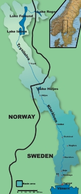
Klarälven is a river
flowing through Norway
and Sweden
. Together with Göta älv
, which it is called as the river has passed through the lake Vänern
, thus regarded as an entity, Göta älv-Klarälven is the longest river in Scandinavia
and in the Nordic countries and its Swedish part the longest river of Sweden. These two rivers also has the largest drainage basin
in the same areas, 50.229 km2 (included all the rivers that run into the lake Vänern), of which 42.468 km2 is located in Sweden, and the rest 7.761 in Norway.
It emanates from Lake Rogen
in Härjedalen
, Sweden, and then passes through the Norwegian Hedmark
, where it flows through the lake Femunden. There it is known as Femundelva and Trysilelva (before the nationalistic movement in the 19th century the river was called Klara even in Norway; today it is called Femundelva in the municipality of Engerdal
and Trysilelva in the municipality of Trysil
, reflecting strong local patriotism in Norway). The rest of the river, the longest part, flows through Värmland
to ultimately discharge in a delta
into Vänern
at Karlstad
.
In its turn, Vänern drains then into Göta älv
, reaching the sea at Gothenburg
.
The river has historically provided significant economic benefits, providing a suitable transport route for log driving
, and currently is internationally recognized as excellent sport fishing waters.
 The watershed
of Klarälven is commonly referred to as Klarälvsdalen (the Klarälv basin), where it accumulates much of its water on its journey to Vänern
. Other important sources of water are the snow
y mountains in the northern areas of the watershed area, providing substantial flows in the spring when the snow melts; annual floods are common.
Since the Ice Age
, the mouth of Klarälven has moved from Forshaga
to its current position at Karlstad
, and is still moving, albeit for different reasons, as the river carries substantial quantities of sand, cut from the outer edges of its meander
ing curves, causing the shoreline of Vänern to constantly move southward.
The heavy meandering of Klarälven results in numerous oxbow lake
s, formed as a result of a too sharp curve, eventually causing the river to create a new, shorter path. An artificial islet, Gubbholmen found in central Karlstad has also been created as a result of the accumulation of 5000 ton
nes sand transported each day during the spring flood.
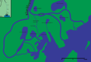
Entering the Karlstad region, the river delta
splits into two main parts and eight smaller parts. The east part splits into two further main branches after passing Gubbholmen (eventually three branches). The west part splits into five branches.
and brown trout
fisheries; these two species of fish are sought after by fly fishers. Competition for use of areas rich in the popular species is vigorous, and at high season the price of fishing licenses may be as high as 500 SEK
($68 USD) per day. Other measures are taken to ensure the survival of the fishery, including strict rules on the minimum sizes and quantities of fish allowed to be taken, as well as the requirement that unwanted fish, such as the northern pike
, be killed when caught.
Although the river was a busy log driving route, it has been reported that the fish populations of Klarälven has not suffered from the heavy activity, underwater life benefited from it, especially the grayling
population. When the logging stopped in 1991, it was later reported that the beneficial effects were slowly disappearing as shore vegetation grew denser, providing a less favourable environment for the fish.
As of 1997, an upper secondary school specializing in sport fishing education was established to meet the demands for skilled professionals to guide fishing tourism.
Modern day tourist attractions in addition to sport fishing include canoe
ing, as well as rafting from Branäs to Edebäck.

 Log driving
has been traced back to the 17th century, although log driving increased to a significant level at the beginning of the 20th century, when the paper industry started to expand. Log driving was accomplished by dumping the harvested logs into the river, there they floated until the separation point at Forshaga. They were then held up by a floating structure resembling a fence until loggers could move out on the logs, identify them and guide them to their designated areas using special hooks. After grouping logs with the same company marks together, the logs would then be towed to their destinations.
As many as 1500 persons were working seasonally, employed by the local log drivers' society, paid by the paper mills and forest owners. Although a risky job, the personnel were skilled and only one drowning incident was reported in the last 30 years of operation.Out of the 19 Lusten boats used to tow the logs to their final destinations, only one remains in working condition today; Lusten 8, serving as a tourist attraction.
After the shutdown of the flood driving industry in 1991, the remaining equipment was auctioned off, most was sold to the Forshaga Municipality, who used the equipment to found the log driving museum, using the old buildings used for the operations as its main building. Upon the shutdown of the flood driving in Klarälven, the practice of log driving in Sweden had officially come to its end.
River
A river is a natural watercourse, usually freshwater, flowing towards an ocean, a lake, a sea, or another river. In a few cases, a river simply flows into the ground or dries up completely before reaching another body of water. Small rivers may also be called by several other names, including...
flowing through Norway
Norway
Norway , officially the Kingdom of Norway, is a Nordic unitary constitutional monarchy whose territory comprises the western portion of the Scandinavian Peninsula, Jan Mayen, and the Arctic archipelago of Svalbard and Bouvet Island. Norway has a total area of and a population of about 4.9 million...
and Sweden
Sweden
Sweden , officially the Kingdom of Sweden , is a Nordic country on the Scandinavian Peninsula in Northern Europe. Sweden borders with Norway and Finland and is connected to Denmark by a bridge-tunnel across the Öresund....
. Together with Göta älv
Göta älv
The Göta is a river that drains lake Vänern into the Kattegat at the city of Gothenburg on the western coast of Sweden. It is located in Götaland, with the river itself being a site of early Geatish settlement. The length is 93 km. Often the combination of Göta älv and Klarälven is mentioned...
, which it is called as the river has passed through the lake Vänern
Vänern
Vänern is the largest lake in Sweden, the largest lake in the EU and the third largest lake in Europe after Ladoga and Onega in Russia. It is located in the provinces of Västergötland, Dalsland, and Värmland in the southwest of the country.- History :...
, thus regarded as an entity, Göta älv-Klarälven is the longest river in Scandinavia
Scandinavia
Scandinavia is a cultural, historical and ethno-linguistic region in northern Europe that includes the three kingdoms of Denmark, Norway and Sweden, characterized by their common ethno-cultural heritage and language. Modern Norway and Sweden proper are situated on the Scandinavian Peninsula,...
and in the Nordic countries and its Swedish part the longest river of Sweden. These two rivers also has the largest drainage basin
Drainage basin
A drainage basin is an extent or an area of land where surface water from rain and melting snow or ice converges to a single point, usually the exit of the basin, where the waters join another waterbody, such as a river, lake, reservoir, estuary, wetland, sea, or ocean...
in the same areas, 50.229 km2 (included all the rivers that run into the lake Vänern), of which 42.468 km2 is located in Sweden, and the rest 7.761 in Norway.
It emanates from Lake Rogen
Rogen
Rogen is a lake situated mainly in Härjedalen, Sweden with a small portion crossing the Norwegian border. It is the source of Sweden's longest river, Klarälven....
in Härjedalen
Härjedalen
' is a historical province or landskap in the centre of Sweden. It borders the country of Norway as well as the provinces of Dalarna, Hälsingland, Medelpad, and Jämtland...
, Sweden, and then passes through the Norwegian Hedmark
Hedmark
is a county in Norway, bordering Sør-Trøndelag, Oppland and Akershus. The county administration is in Hamar.Hedmark makes up the northeastern part of Østlandet, the southeastern part of the country. It includes a long part of the borderline with Sweden, Dalarna County and Värmland County. The...
, where it flows through the lake Femunden. There it is known as Femundelva and Trysilelva (before the nationalistic movement in the 19th century the river was called Klara even in Norway; today it is called Femundelva in the municipality of Engerdal
Engerdal
Engerdal is a municipality in Hedmark county, Norway. It is part of the traditional region of Østerdalen. The administrative centre of the municipality is the village of Engerdal...
and Trysilelva in the municipality of Trysil
Trysil
Trysil is a municipality in Hedmark county, Norway. It is part of the traditional region of Østerdalen. The administrative centre of the municipality is the village of Innbygda...
, reflecting strong local patriotism in Norway). The rest of the river, the longest part, flows through Värmland
Värmland
' is a historical province or landskap in the west of middle Sweden. It borders Västergötland, Dalsland, Dalarna, Västmanland and Närke. It is also bounded by Norway in the west. Latin name versions are Vermelandia and Wermelandia. Although the province's land originally was Götaland, the...
to ultimately discharge in a delta
River delta
A delta is a landform that is formed at the mouth of a river where that river flows into an ocean, sea, estuary, lake, reservoir, flat arid area, or another river. Deltas are formed from the deposition of the sediment carried by the river as the flow leaves the mouth of the river...
into Vänern
Vänern
Vänern is the largest lake in Sweden, the largest lake in the EU and the third largest lake in Europe after Ladoga and Onega in Russia. It is located in the provinces of Västergötland, Dalsland, and Värmland in the southwest of the country.- History :...
at Karlstad
Karlstad
Karlstad is a city, the seat of Karlstad Municipality, the capital of Värmland County, and the largest city in the province Värmland in Sweden. The city had 61,685 inhabitants in 2010 out of a municipal total that during the first quarter 2010 was 84,885 inhabitants...
.
In its turn, Vänern drains then into Göta älv
Göta älv
The Göta is a river that drains lake Vänern into the Kattegat at the city of Gothenburg on the western coast of Sweden. It is located in Götaland, with the river itself being a site of early Geatish settlement. The length is 93 km. Often the combination of Göta älv and Klarälven is mentioned...
, reaching the sea at Gothenburg
Gothenburg
Gothenburg is the second-largest city in Sweden and the fifth-largest in the Nordic countries. Situated on the west coast of Sweden, the city proper has a population of 519,399, with 549,839 in the urban area and total of 937,015 inhabitants in the metropolitan area...
.
The river has historically provided significant economic benefits, providing a suitable transport route for log driving
Log driving
Log driving is a means of log transport which makes use of a river's current to move floating tree trunks downstream to sawmills and pulp mills.It was the main transportation method of the early logging industry in Europe and North America...
, and currently is internationally recognized as excellent sport fishing waters.
Geography
Drainage basin
A drainage basin is an extent or an area of land where surface water from rain and melting snow or ice converges to a single point, usually the exit of the basin, where the waters join another waterbody, such as a river, lake, reservoir, estuary, wetland, sea, or ocean...
of Klarälven is commonly referred to as Klarälvsdalen (the Klarälv basin), where it accumulates much of its water on its journey to Vänern
Vänern
Vänern is the largest lake in Sweden, the largest lake in the EU and the third largest lake in Europe after Ladoga and Onega in Russia. It is located in the provinces of Västergötland, Dalsland, and Värmland in the southwest of the country.- History :...
. Other important sources of water are the snow
Snow
Snow is a form of precipitation within the Earth's atmosphere in the form of crystalline water ice, consisting of a multitude of snowflakes that fall from clouds. Since snow is composed of small ice particles, it is a granular material. It has an open and therefore soft structure, unless packed by...
y mountains in the northern areas of the watershed area, providing substantial flows in the spring when the snow melts; annual floods are common.
Since the Ice Age
Ice age
An ice age or, more precisely, glacial age, is a generic geological period of long-term reduction in the temperature of the Earth's surface and atmosphere, resulting in the presence or expansion of continental ice sheets, polar ice sheets and alpine glaciers...
, the mouth of Klarälven has moved from Forshaga
Forshaga
Forshaga is a locality and the seat of Forshaga Municipality, Värmland County, Sweden with 6,355 inhabitants in 2005.-Notable natives:* Stefan Holm, high jump Olympic champion in 2004.* Oskar Olofsson, guitarist in Swedish indie rock group Molotov Jive....
to its current position at Karlstad
Karlstad
Karlstad is a city, the seat of Karlstad Municipality, the capital of Värmland County, and the largest city in the province Värmland in Sweden. The city had 61,685 inhabitants in 2010 out of a municipal total that during the first quarter 2010 was 84,885 inhabitants...
, and is still moving, albeit for different reasons, as the river carries substantial quantities of sand, cut from the outer edges of its meander
Meander
A meander in general is a bend in a sinuous watercourse. A meander is formed when the moving water in a stream erodes the outer banks and widens its valley. A stream of any volume may assume a meandering course, alternately eroding sediments from the outside of a bend and depositing them on the...
ing curves, causing the shoreline of Vänern to constantly move southward.
The heavy meandering of Klarälven results in numerous oxbow lake
Oxbow lake
An oxbow lake is a U-shaped body of water formed when a wide meander from the main stem of a river is cut off to create a lake. This landform is called an oxbow lake for the distinctive curved shape, named after part of a yoke for oxen. In Australia, an oxbow lake is called a billabong, derived...
s, formed as a result of a too sharp curve, eventually causing the river to create a new, shorter path. An artificial islet, Gubbholmen found in central Karlstad has also been created as a result of the accumulation of 5000 ton
Ton
The ton is a unit of measure. It has a long history and has acquired a number of meanings and uses over the years. It is used principally as a unit of weight, and as a unit of volume. It can also be used as a measure of energy, for truck classification, or as a colloquial term.It is derived from...
nes sand transported each day during the spring flood.
Entering the Karlstad region, the river delta
River delta
A delta is a landform that is formed at the mouth of a river where that river flows into an ocean, sea, estuary, lake, reservoir, flat arid area, or another river. Deltas are formed from the deposition of the sediment carried by the river as the flow leaves the mouth of the river...
splits into two main parts and eight smaller parts. The east part splits into two further main branches after passing Gubbholmen (eventually three branches). The west part splits into five branches.
Economic importance
There are some hydroelectric power plants in the river. These are the hydro powerplants from south to north.- Forshaga powerplant in Forshaga,
- Dejefors powerplant in Dejeforsen, 20 MW, in the middle of central Deje,
- Munkfors powerplant in Munkfors, 33 MW,
- Skymnäsforsens powerplant in Skymnäsforsen in Skymnäsfors, 17 MW,
- Forshults powerplant in Forshult, 20 MW,
- Krakeruds powerplant in Krakerud, 22 MW,
- Skogaforsens powerplant in Skogaforsen i Skogafors 15 MW,
- Edsforsens powerplant in Edsforsen in Edsfors 9 MW och
- Höljes powerplant in Höljes, 130 MW.
Fishing
In recent years, the sport fishing of Klarälven has gained an international recognition for its Atlantic salmonAtlantic salmon
The Atlantic salmon is a species of fish in the family Salmonidae, which is found in the northern Atlantic Ocean and in rivers that flow into the north Atlantic and the north Pacific....
and brown trout
Brown trout
The brown trout and the sea trout are fish of the same species....
fisheries; these two species of fish are sought after by fly fishers. Competition for use of areas rich in the popular species is vigorous, and at high season the price of fishing licenses may be as high as 500 SEK
Swedish krona
The krona has been the currency of Sweden since 1873. Both the ISO code "SEK" and currency sign "kr" are in common use; the former precedes or follows the value, the latter usually follows it, but especially in the past, it sometimes preceded the value...
($68 USD) per day. Other measures are taken to ensure the survival of the fishery, including strict rules on the minimum sizes and quantities of fish allowed to be taken, as well as the requirement that unwanted fish, such as the northern pike
Northern Pike
The northern pike , is a species of carnivorous fish of the genus Esox...
, be killed when caught.
Although the river was a busy log driving route, it has been reported that the fish populations of Klarälven has not suffered from the heavy activity, underwater life benefited from it, especially the grayling
Grayling (species)
The grayling is a species of freshwater fish in the salmon family of order Salmoniformes. It is the type species of its genus. Native to the Palearctic ecozone, the grayling is widespread throughout northern Europe, from the United Kingdom and France to the Ural Mountains in Russia...
population. When the logging stopped in 1991, it was later reported that the beneficial effects were slowly disappearing as shore vegetation grew denser, providing a less favourable environment for the fish.
As of 1997, an upper secondary school specializing in sport fishing education was established to meet the demands for skilled professionals to guide fishing tourism.
Other tourism
Klarälven has clean and fresh water, suitable for bathing, although caution must be taken if bathing at a point before the river reaches its delta, as the currents can be treacherous.Modern day tourist attractions in addition to sport fishing include canoe
Canoe
A canoe or Canadian canoe is a small narrow boat, typically human-powered, though it may also be powered by sails or small electric or gas motors. Canoes are usually pointed at both bow and stern and are normally open on top, but can be decked over A canoe (North American English) or Canadian...
ing, as well as rafting from Branäs to Edebäck.
Log driving
Log driving
Log driving is a means of log transport which makes use of a river's current to move floating tree trunks downstream to sawmills and pulp mills.It was the main transportation method of the early logging industry in Europe and North America...
has been traced back to the 17th century, although log driving increased to a significant level at the beginning of the 20th century, when the paper industry started to expand. Log driving was accomplished by dumping the harvested logs into the river, there they floated until the separation point at Forshaga. They were then held up by a floating structure resembling a fence until loggers could move out on the logs, identify them and guide them to their designated areas using special hooks. After grouping logs with the same company marks together, the logs would then be towed to their destinations.
As many as 1500 persons were working seasonally, employed by the local log drivers' society, paid by the paper mills and forest owners. Although a risky job, the personnel were skilled and only one drowning incident was reported in the last 30 years of operation.Out of the 19 Lusten boats used to tow the logs to their final destinations, only one remains in working condition today; Lusten 8, serving as a tourist attraction.
After the shutdown of the flood driving industry in 1991, the remaining equipment was auctioned off, most was sold to the Forshaga Municipality, who used the equipment to found the log driving museum, using the old buildings used for the operations as its main building. Upon the shutdown of the flood driving in Klarälven, the practice of log driving in Sweden had officially come to its end.