

Geographical center of Sweden
Encyclopedia
Sweden
Sweden , officially the Kingdom of Sweden , is a Nordic country on the Scandinavian Peninsula in Northern Europe. Sweden borders with Norway and Finland and is connected to Denmark by a bridge-tunnel across the Öresund....
is contested amongst at least two locations.
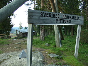
The oldest and most famous geographical center of Sweden is Flataklocken, a spot next to Lake Munkby in Ånge
Ånge
Ånge is a locality and the seat of Ånge Municipality in Västernorrland County, Sweden with 2,956 inhabitants in 2005.Ånge is a railway junction where the northern main line railway connected with the central main line railway .- References :...
, Medelpad
Medelpad
' is a historical province or landskap in the north of Sweden. It borders to Hälsingland, Härjedalen, Jämtland, Ångermanland and the Gulf of Bothnia....
at 62°23′15"N 16°19′32"E. The site was identified in 1947 after an initiative by the newspaperman Gustaf von Platen. The method used for calculating this point was that of the centre of gravity of the geometrical figure of Sweden. The calculation was made by professor Nils Friberg and Tor Andeldorf at the geography department of Stockholm University
Stockholm University
Stockholm University is a state university in Stockholm, Sweden. It has over 28,000 students at four faculties, making it one of the largest universities in Scandinavia. The institution is also frequently regarded as one of the top 100 universities in the world...
, using a cardboard cutout map of Sweden with outlying islands attached directly to the mainland. They balanced the map model on a needle and declared the balancing point the geographical center.
A delegation including Gustaf von Platen, explorer Hans Ostelius and orienteer
Orienteering
Orienteering is a family of sports that requires navigational skills using a map and compass to navigate from point to point in diverse and usually unfamiliar terrain, and normally moving at speed. Participants are given a topographical map, usually a specially prepared orienteering map, which they...
Gösta Lagerfelt trekked through the wilderness to the site and declared it the geographical center. Later, a sign marking the significance of the spot was erected and a lookout built. The site has since become a popular tourist attraction
Tourist attraction
A tourist attraction is a place of interest where tourists visit, typically for its inherent or exhibited cultural value, historical significance, natural or built beauty, or amusement opportunities....
.
Area towns Ånge
Ånge
Ånge is a locality and the seat of Ånge Municipality in Västernorrland County, Sweden with 2,956 inhabitants in 2005.Ånge is a railway junction where the northern main line railway connected with the central main line railway .- References :...
and Östersund
Östersund
Östersund is an urban area in Jämtland in the middle of Sweden. It is the seat of Östersund Municipality and the capital of Jämtland County. Östersund is located at the shores of Sweden's fifth largest lake, Storsjön, opposite the island Frösön, and is the only city in Jämtland. Östersund is the...
often claim to be the geographical center of Sweden.
Other places have been claimed to be the centre of Sweden, using differing methods. The most prominent is Ytterhogdal in Hälsingland
Hälsingland
' is a historical province or landskap in central Sweden. It borders to Gästrikland, Dalarna, Härjedalen, Medelpad and to the Gulf of Bothnia...
, based on the methodology of calculating the latitude for the point halfway between the northernmost (Treriksröset
Treriksröset
Treriksröset , Treriksrøysa , Kolmen valtakunnan rajapyykki is the point at which the borders of Sweden, Norway and Finland meet....
) and southernmost (southern tip of Skåne) points, and then taking the mid between the easternmost and westernmost points at that latitude.