

Geography of Ethiopia
Encyclopedia
Ethiopia
Ethiopia , officially known as the Federal Democratic Republic of Ethiopia, is a country located in the Horn of Africa. It is the second-most populous nation in Africa, with over 82 million inhabitants, and the tenth-largest by area, occupying 1,100,000 km2...
is located in the Horn of Africa
Horn of Africa
The Horn of Africa is a peninsula in East Africa that juts hundreds of kilometers into the Arabian Sea and lies along the southern side of the Gulf of Aden. It is the easternmost projection of the African continent...
and is bordered on the north and northeast by Eritrea
Eritrea
Eritrea , officially the State of Eritrea, is a country in the Horn of Africa. Eritrea derives it's name from the Greek word Erethria, meaning 'red land'. The capital is Asmara. It is bordered by Sudan in the west, Ethiopia in the south, and Djibouti in the southeast...
, on the east by Djibouti
Djibouti
Djibouti , officially the Republic of Djibouti , is a country in the Horn of Africa. It is bordered by Eritrea in the north, Ethiopia in the west and south, and Somalia in the southeast. The remainder of the border is formed by the Red Sea and the Gulf of Aden at the east...
and Somalia
Somalia
Somalia , officially the Somali Republic and formerly known as the Somali Democratic Republic under Socialist rule, is a country located in the Horn of Africa. Since the outbreak of the Somali Civil War in 1991 there has been no central government control over most of the country's territory...
, on the south by Kenya
Kenya
Kenya , officially known as the Republic of Kenya, is a country in East Africa that lies on the equator, with the Indian Ocean to its south-east...
, on the northwest by Sudan
Sudan
Sudan , officially the Republic of the Sudan , is a country in North Africa, sometimes considered part of the Middle East politically. It is bordered by Egypt to the north, the Red Sea to the northeast, Eritrea and Ethiopia to the east, South Sudan to the south, the Central African Republic to the...
and on the southwest by South Sudan
South Sudan
South Sudan , officially the Republic of South Sudan, is a landlocked country located in the Sahel region of northeastern Africa. It is also part of the North Africa UN sub-region. Its current capital is Juba, which is also its largest city; the capital city is planned to be moved to the more...
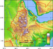
. The country has a high central plateau that varies from 1290 to 3000 m (4,232.3 to 9,842.5 ft) above sea level, with the highest mountain reaching 4533 m (14,872 ft). Elevation is generally highest just before the point of descent to the Great Rift Valley
Great Rift Valley
The Great Rift Valley is a name given in the late 19th century by British explorer John Walter Gregory to the continuous geographic trench, approximately in length, that runs from northern Syria in Southwest Asia to central Mozambique in South East Africa...
, which splits the plateau diagonally. A number of rivers cross the plateau—notably the Blue Nile
Blue Nile
The Blue Nile is a river originating at Lake Tana in Ethiopia. With the White Nile, the river is one of the two major tributaries of the Nile...
rising from Lake Tana
Lake Tana
Lake Tana is the source of the Blue Nile and is the largest lake in Ethiopia...
. The plateau gradually slopes to the lowlands of the Sudan on the west and the Somali-inhabited plains to the southeast.
Topography
Between the valley of the Upper NileNile
The Nile is a major north-flowing river in North Africa, generally regarded as the longest river in the world. It is long. It runs through the ten countries of Sudan, South Sudan, Burundi, Rwanda, Democratic Republic of the Congo, Tanzania, Kenya, Ethiopia, Uganda and Egypt.The Nile has two major...
and Ethiopia's border with Eritrea
Eritrea
Eritrea , officially the State of Eritrea, is a country in the Horn of Africa. Eritrea derives it's name from the Greek word Erethria, meaning 'red land'. The capital is Asmara. It is bordered by Sudan in the west, Ethiopia in the south, and Djibouti in the southeast...
is a region of elevated plateau
Plateau
In geology and earth science, a plateau , also called a high plain or tableland, is an area of highland, usually consisting of relatively flat terrain. A highly eroded plateau is called a dissected plateau...
s from which rise the various tablelands and mountains that constitute the Ethiopian Highlands
Ethiopian Highlands
The Ethiopian Highlands are a rugged mass of mountains in Ethiopia, Eritrea , and northern Somalia in the Horn of Africa...
. On nearly every side, the walls of the plateaus rise abruptly from the plain
Plain
In geography, a plain is land with relatively low relief, that is flat or gently rolling. Prairies and steppes are types of plains, and the archetype for a plain is often thought of as a grassland, but plains in their natural state may also be covered in shrublands, woodland and forest, or...
s, constituting outer mountain chains. The highlands are thus a clearly marked orographic division. In Eritrea
Eritrea
Eritrea , officially the State of Eritrea, is a country in the Horn of Africa. Eritrea derives it's name from the Greek word Erethria, meaning 'red land'. The capital is Asmara. It is bordered by Sudan in the west, Ethiopia in the south, and Djibouti in the southeast...
, the eastern wall of this plateau runs parallel to the Red Sea
Red Sea
The Red Sea is a seawater inlet of the Indian Ocean, lying between Africa and Asia. The connection to the ocean is in the south through the Bab el Mandeb strait and the Gulf of Aden. In the north, there is the Sinai Peninsula, the Gulf of Aqaba, and the Gulf of Suez...
from Ras Kasar
Ras Kasar
Ras Kasar is a cape in northeastern Africa, on border between Eritrea and Sudan at the Red Sea. It is the northernmost point in Eritrea and the easternmost point in Sudan....
(18° N
18th parallel north
The 18th parallel north is a circle of latitude that is 18 degrees north of the Earth's equatorial plane. It crosses Africa, Asia, the Indian Ocean, the Pacific Ocean, Central America, the Caribbean and the Atlantic Ocean....
) to Annesley Bay (also known as the Bay of Zula
Zula
Zula is a small town in central Eritrea. It is situated near the head of Annesley Bay , on the Red Sea coast...
) (15° N
15th parallel north
The 15th parallel north is a circle of latitude that is 15 degrees north of the Earth's equatorial plane. It crosses Africa, Asia, the Indian Ocean, the Pacific Ocean, Central America, the Caribbean and the Atlantic Ocean....
). It then turns due south into Ethiopia and follows closely the line of 40° E
40th meridian east
The meridian 40° east of Greenwich is a line of longitude that extends from the North Pole across the Arctic Ocean, Europe, Asia, Africa, the Indian Ocean, the Southern Ocean, and Antarctica to the South Pole....
for some 600 km (373 mi). About 9° N
9th parallel north
The 9th parallel north is a circle of latitude that is 9 degrees north of the Earth's equatorial plane. It crosses Africa, the Indian Ocean, South Asia, Southeast Asia, the Pacific Ocean, Central America, South America and the Atlantic Ocean....
there is a break in the wall, through which the Awash River
Awash River
The Awash is a major river of Ethiopia. Its course is entirely contained within the boundaries of Ethiopia, and empties into a chain of interconnected lakes that begin with Lake Gargori and end with Lake Abbe on the border with Djibouti, some 100 kilometers from the head of the Gulf of Tadjoura...
flows eastward. The main range at this point trends southwest, while south of the Awash Valley, which is some 1000 m (3,281 ft) below the level of the mountains, another massif
Massif
In geology, a massif is a section of a planet's crust that is demarcated by faults or flexures. In the movement of the crust, a massif tends to retain its internal structure while being displaced as a whole...
rises in a direct line south. This second range sends a chain (the Ahmar mountains
Ahmar Mountains
The Ahmar Mountains are a range adjacent to the Ethiopian city of Diredawa....
) eastward toward the Gulf of Aden
Gulf of Aden
The Gulf of Aden is located in the Arabian Sea between Yemen, on the south coast of the Arabian Peninsula, and Somalia in the Horn of Africa. In the northwest, it connects with the Red Sea through the Bab-el-Mandeb strait, which is about 20 miles wide....
. The two chief eastern ranges maintain a parallel course south by west, with a broad upland valley in between — in which valley are a series of lakes — to about 3° N
3rd parallel north
The 3rd parallel north is a circle of latitude that is 3 degrees north of the Earth's equatorial plane. It crosses the Atlantic Ocean, Africa, the Indian Ocean, Southeast Asia, the Pacific Ocean and South America....
, the outer (eastern) spurs of the plateau still keeping along the line of 40° E
40th meridian east
The meridian 40° east of Greenwich is a line of longitude that extends from the North Pole across the Arctic Ocean, Europe, Asia, Africa, the Indian Ocean, the Southern Ocean, and Antarctica to the South Pole....
. The southern escarpment of the plateau is highly irregular, but has a general direction northwest and southeast from 6° N
6th parallel north
The 6th parallel north is a circle of latitude that is 6 degrees north of the Earth's equatorial plane. It crosses Africa, the Indian Ocean, Southeast Asia, the Pacific Ocean, South America and the Atlantic Ocean....
to 3° N
3rd parallel north
The 3rd parallel north is a circle of latitude that is 3 degrees north of the Earth's equatorial plane. It crosses the Atlantic Ocean, Africa, the Indian Ocean, Southeast Asia, the Pacific Ocean and South America....
. It overlooks the depression in which is Lake Turkana
Lake Turkana
Lake Turkana , formerly known as Lake Rudolf, is a lake in the Great Rift Valley in Kenya, with its far northern end crossing into Ethiopia. It is the world's largest permanent desert lake and the world's largest alkaline lake...
and — east of that lake — the southern Debub Omo Zone
Debub Omo Zone
Debub Omo is a Zone in the Ethiopian Southern Nations, Nationalities and Peoples Region . Debub Omo is bordered on the south by Kenya, on the southwest by the Ilemi Triangle, on the west by Bench Maji, on the northwest by Keficho Shekicho, on the north by Semien Omo, on the northeast by the...
(part of the larger Southern Nations, Nationalities, and Peoples Region). The western wall of the plateau from 6° N
6th parallel north
The 6th parallel north is a circle of latitude that is 6 degrees north of the Earth's equatorial plane. It crosses Africa, the Indian Ocean, Southeast Asia, the Pacific Ocean, South America and the Atlantic Ocean....
to 11° N
11th parallel north
The 11th parallel north is a circle of latitude that is 11 degrees north of the Earth's equatorial plane. It crosses Africa, the Indian Ocean, South Asia, Southeast Asia, the Pacific Ocean, Central America, South America and the Atlantic Ocean....
is well marked and precipitous. North of 11° N
11th parallel north
The 11th parallel north is a circle of latitude that is 11 degrees north of the Earth's equatorial plane. It crosses Africa, the Indian Ocean, South Asia, Southeast Asia, the Pacific Ocean, Central America, South America and the Atlantic Ocean....
the hills turn more to the east and fall more gradually to the East Sudanian savanna
East Sudanian savanna
The East Sudanian Savanna is a hot, dry, tropical savanna ecoregion of central Africa.-Location and description:This is the eastern half of the broad savanna belt which runs east and west across Africa, this section lying east of the Cameroon Highlands...
plains at their base. On its northern face the plateau falls in terraces to the level of the eastern Sudan
Sudan
Sudan , officially the Republic of the Sudan , is a country in North Africa, sometimes considered part of the Middle East politically. It is bordered by Egypt to the north, the Red Sea to the northeast, Eritrea and Ethiopia to the east, South Sudan to the south, the Central African Republic to the...
. The eastern escarpment is the best defined of these outer ranges. It has a mean height of 2100 to 2400 m (6,889.8 to 7,874 ft), and in many places rises almost perpendicularly from the plain. Narrow and deep clefts, through which descend mountain torrents that lose themselves in the sandy soil of the Eritrean coast, afford means of reaching the plateau, or the easier route through the Awash Valley may be chosen. On surmounting this rocky barrier, the traveller finds that the encircling rampart rises little above the normal level of the plateau.
The physical aspect of the highlands is impressive. The northern portion, lying mainly between 10°
10th parallel north
The 10th parallel north is a circle of latitude that is 10 degrees north of the Earth's equatorial plane. It crosses Africa, the Indian Ocean, South Asia, Southeast Asia, the Pacific Ocean, Central America, South America and the Atlantic Ocean....
and 15° N
15th parallel north
The 15th parallel north is a circle of latitude that is 15 degrees north of the Earth's equatorial plane. It crosses Africa, Asia, the Indian Ocean, the Pacific Ocean, Central America, the Caribbean and the Atlantic Ocean....
, consists of a huge mass of Archaean rocks with a mean height of 2000 to 2200 m (6,561.7 to 7,217.8 ft) above sea level, and is flooded in a deep central depression by the waters of Lake Tana
Lake Tana
Lake Tana is the source of the Blue Nile and is the largest lake in Ethiopia...
. Above the plateau rise several irregular and generally ill-defined mountain ranges which attain altitudes of from 3700 m (12,139 ft) to just under 4600 m (15,092 ft). Many of the mountains are of unusual shape. Characteristic of the country are the enormous fissures
Canyon
A canyon or gorge is a deep ravine between cliffs often carved from the landscape by a river. Rivers have a natural tendency to reach a baseline elevation, which is the same elevation as the body of water it will eventually drain into. This forms a canyon. Most canyons were formed by a process of...
which divide it, formed over time by the erosive
Erosion
Erosion is when materials are removed from the surface and changed into something else. It only works by hydraulic actions and transport of solids in the natural environment, and leads to the deposition of these materials elsewhere...
action of water. They are in fact the valleys of the rivers which, rising on the uplands or mountain sides, have cut their way to the surrounding lowlands. Some of the valleys are of considerable width; in other cases the opposite walls of the gorges are but two or three hundred meters apart, and fall almost vertically thousands of meters, representing an erosion of many hundred thousands cubic metres of hard rock. One result of the action of the water has been the formation of numerous isolated flat-topped hills or small plateaus, known as ambas
Amba (geology)
An amba is a characteristic geologic form in Ethiopia. It is a steep sided, flat topped mountain, often the site of villages, wells and their surrounding farmland. These settlements were located there because they were very defensible and often virtually inaccessible plateaus.The original term in...
, with nearly perpendicular sides. The highest peaks are found in the Semien
Semien Mountains
The Semien Mountains lie in northern Ethiopia, north east of Gondar. They are a World Heritage Site and include the Semien Mountains National Park. The mountains consist of plateaux separated by valleys and rising to pinnacles...
and Bale
Bale Mountains
The Bale Mountains are a range of mountains in the Oromia Region of southeast Ethiopia, south of the Awash River. They include Tullu Demtu, the second-highest mountain in Ethiopia , and Mount Batu . The Weyib River, a tributary of the Jubba River, rises in these mountains east of Goba...
ranges. The Semien Mountains lie northeast of Lake Tana and culminate in the snow-covered peak of Ras Dejen, which has an altitude of 4550 m (14,928 ft). A few kilometers east and north respectively of Ras Dejen are Mounts Biuat
Mount Biuat
Mount Bwahit is a peak of the Semien Mountains in the Amhara Region of Ethiopia. Its altitude is estimated at 4430 or 4437 m above sea level, making it the second highest mountain in Ethiopia. It is located about 16 km west of the highest, Ras Dashen, from which it is separated by a 1,600 m deep...
and Abba Yared, whose summits are less than 100 metres (328 ft) below that of Ras Dejen. The Bale Mountains are separated from the larger part of the Ethiopian highlands by the Great Rift Valley
Great Rift Valley
The Great Rift Valley is a name given in the late 19th century by British explorer John Walter Gregory to the continuous geographic trench, approximately in length, that runs from northern Syria in Southwest Asia to central Mozambique in South East Africa...
, one of the longest and most profound chasms in Ethiopia. The highest peaks of that range include Tullu Demtu
Mount Tullu Demtu
Tullu Demtu is the second-highest mountain in Ethiopia after Ras Dashen.Tullu Demtu is part of range of mountains Bale in Oromia Region in southeast Ethiopia, located in the Bale National Park. It forms part of the divide between the drainage basins of the Weyib and Shebelle Rivers.-External links:*...
, the second-highest mountain in Ethiopia (4377 m (14,360 ft)), Batu
Mount Batu
Mount Batu is one of the highest of the Bale Mountains of Ethiopia, as well as of the Oromia Region. Part of the Bale National Park, and located at , it reaches an elevation of 4,307 meters. It consists of two peaks, Tinnish Batu , which is actually higher than Tilliq Batu to the south...
(4307 m (14,131 ft)), Chilalo
Mount Chilalo
Mount Chilalo is an isolated, extinct silicic volcanic mountain in southeastern Ethiopia. The highest point in the Arsi Zone of the Oromia Region, and located on the border between the Hitosa and Tiyo woreda, this mountain has a latitude and longitude of with an elevation of above sea level.The...
(4036 m (13,241 ft)) and Mount Kaka (3820 m (12,533 ft)).
Parallel with the eastern escarpment are the heights of Biala, 3810 m (12,500 ft), Mount Abuna Yosef
Mount Abuna Yosef
Abuna Yosef is the 16th tallest mountain in Ethiopia; it reaches an elevation of 4260 meters. Located in the Semien Wollo Zone of the Amhara Region, near the eastern escarpment of the Ethiopian highlands, this mountain has a latitude and longitude of ....
, 4190 m (13,747 ft), and Kollo
Kollo
-Sister city:-References:...
, 4300 m (14,108 ft), the last-named being southwest of Magdala. Between Lake Tana and the eastern hills are Mounts Guna
Mount Guna
Mount Guna or Guna Terara is a mountain located near the city of Debre Tabor, in Ethiopia, in the Amhara region. It is the highest point in the Debub Gondar Zone....
, 4210 m (13,812 ft), and Uara Sahia, 3960 m (12,992 ft). In the Choqa Mountains of Misraq Gojjam
Misraq Gojjam Zone
Misraq Gojjam is a Zone in the Amhara Region of Ethiopia. Misraq Gojjam is named after the former province of Gojjam.Misraq Gojjam is bordered on the south by the Oromia Region, on the west by Mirab Gojjam, on the north by Debub Gondar, and on the east by Debub Wollo; the bend of the Abay River...
, Mount Choqa
Mount Choqa
Mount Choqa is one of the highest mountains of Gojjam, a region of Ethiopia located south of Lake Tana. The range lacks forests and its slopes are cultivated up to an elevation of 3,000 metres above sea level....
(also known as Mount Birhan) attains a height of 4154 m (13,629 ft). Below 10° N
10th parallel north
The 10th parallel north is a circle of latitude that is 10 degrees north of the Earth's equatorial plane. It crosses Africa, the Indian Ocean, South Asia, Southeast Asia, the Pacific Ocean, Central America, South America and the Atlantic Ocean....
, the southern portion of the highlands has more open tableland than the northern portion and fewer lofty peaks. Though there are a few heights between 3000 and 4000 m (9,842.5 and 13,123.4 ft), the majority do not exceed 2400 m (7,874 ft), but the general character of the southern regions is the same as in the north: a much-broken hilly plateau.
East of the highlands towards the Red Sea
Red Sea
The Red Sea is a seawater inlet of the Indian Ocean, lying between Africa and Asia. The connection to the ocean is in the south through the Bab el Mandeb strait and the Gulf of Aden. In the north, there is the Sinai Peninsula, the Gulf of Aqaba, and the Gulf of Suez...
there is a strip of lowland semi-desert, the Ethiopian xeric grasslands and shrublands
Ethiopian xeric grasslands and shrublands
The Ethiopian xeric grasslands and shrublands ecoregion is a semi-desert strip on or near the Red Sea and the Gulf of Oman coasts in Eritrea, Ethiopia, Djibouti and Somaliland.-Location and description:...
.
Hydrology
Most of the Ethiopian uplands have a decided slope to the north-west, so that nearly all the large rivers flow in that direction to the Nile, comprising some 85% of its water. Such are the Tekezé RiverTekezé River
The Tekezé River, also known as the Takkaze River, is a major river of Ethiopia, and forms a section the westernmost border of Ethiopia and Eritrea for part of its course. The river is also known as the Setit in Eritrea, western Ethiopia, and eastern Sudan. According to materials published by the...
in the north, the Abay in the center, and the Sobat
Sobat River
The Sobat River is a river in South Sudan, Africa. The most southerly of the great eastern tributaries of the Nile, the Sobat enters the White Nile at Doleib Hill, near the city of Malakal in the Upper Nile state of South Sudan...
in the south, and about four-fifths of the entire drainage is discharged through these three arteries. The rest is carried off by the Awash
Awash River
The Awash is a major river of Ethiopia. Its course is entirely contained within the boundaries of Ethiopia, and empties into a chain of interconnected lakes that begin with Lake Gargori and end with Lake Abbe on the border with Djibouti, some 100 kilometers from the head of the Gulf of Tadjoura...
, which runs out in the saline lacustrine district along the border with Djibouti
Djibouti
Djibouti , officially the Republic of Djibouti , is a country in the Horn of Africa. It is bordered by Eritrea in the north, Ethiopia in the west and south, and Somalia in the southeast. The remainder of the border is formed by the Red Sea and the Gulf of Aden at the east...
; by the Shebelle River
Shebelle River
The Shebelle River begins in the highlands of Ethiopia, and then flows southeast into Somalia towards Mogadishu. Near Mogadishu, it turns sharply southwest, where it follows the coast. Below Mogadishu, the river becomes seasonal...
and the Jubba
Jubba River
The Jubba River is a river in southern Somalia. It begins at the border with Ethiopia, where the Dawa and Ganale Dorya rivers meet, and flows directly south to the Indian Ocean, where it empties at the Goobweyn juncture.-History:...
, which flow southeast through Somalia
Somalia
Somalia , officially the Somali Republic and formerly known as the Somali Democratic Republic under Socialist rule, is a country located in the Horn of Africa. Since the outbreak of the Somali Civil War in 1991 there has been no central government control over most of the country's territory...
, though the Shebelle fails to reach the Indian Ocean
Indian Ocean
The Indian Ocean is the third largest of the world's oceanic divisions, covering approximately 20% of the water on the Earth's surface. It is bounded on the north by the Indian Subcontinent and Arabian Peninsula ; on the west by eastern Africa; on the east by Indochina, the Sunda Islands, and...
; and by the Omo
Omo River
The Omo River is an important river of southern Ethiopia. Its course is entirely contained within the boundaries of Ethiopia, and empties into Lake Turkana on the border with Kenya...
, the main feeder of the closed basin of Lake Turkana
Lake Turkana
Lake Turkana , formerly known as Lake Rudolf, is a lake in the Great Rift Valley in Kenya, with its far northern end crossing into Ethiopia. It is the world's largest permanent desert lake and the world's largest alkaline lake...
.
The Tekezé River, which is the true upper course of the Atbarah River
Atbarah River
The Atbarah River in northeast Africa rises in northwest Ethiopia, approximately 50 km north of Lake Tana and 30 km west of Gondar. It flows about 805 km to the Nile in north-central Sudan, joining it at the city of Atbarah...
, has its headwaters in the central tableland; and falls from about 2100 to 750 m (6,889.8 to 2,460.6 ft). in the tremendous crevasse through which it sweeps west, north, forming part of the border with Eritrea, and west again down to the western terraces, where it passes from Ethiopia to Sudan. During the rains the Tekezé (i.e. the "Terrible") rises some 5 m (16.4 ft) above its normal level, and at this time forms an impassable barrier between the northern and central regions. In its lower course, the river is known by the Arabic
Arabic language
Arabic is a name applied to the descendants of the Classical Arabic language of the 6th century AD, used most prominently in the Quran, the Islamic Holy Book...
name Setit. In Sudan, the Setit is joined (at 14°20′N 35°51′E) by the Atbarah, a river formed by several streams which rise in the mountains west and northwest of Lake Tana
Lake Tana
Lake Tana is the source of the Blue Nile and is the largest lake in Ethiopia...
. The Gash or Mareb
Mareb River
The Mareb River , is a river flowing out of central Eritrea. Its chief importance is defining part of the boundary between Eritrea and Ethiopia between the point where the Mai Ambassa enters the river at to the confluence of the Balasa with the Mareb at .According to the Statistical Abstract of...
, which forms part of the border with Eritrea
Eritrea
Eritrea , officially the State of Eritrea, is a country in the Horn of Africa. Eritrea derives it's name from the Greek word Erethria, meaning 'red land'. The capital is Asmara. It is bordered by Sudan in the west, Ethiopia in the south, and Djibouti in the southeast...
, is the most northerly of the highland rivers which flow toward the Nile valley. Its headwaters rise on the landward side of the eastern escarpment within 80 km of Annesley Bay on the Red Sea. It reaches the Sudanese plains near Kassala
Kassala
Kassala is the capital of the state of Kassala in eastern Sudan. Its 2008 population was recorded to be 419,030. It is a market town and is famous for its fruit gardens. It was formerly a railroad hub, however, as of 2006 there was no operational railway station in Kassala and much of the track...
, beyond which place its waters are dissipated in the sandy soil. The Mareb is dry for a great part of the year, but like the Takazze is subject to sudden freshets during the rainy season. Only the left bank of the upper course of the river is in Ethiopian territory.
The Abay — that is, the upper course of the Blue Nile — has its source near Mount Denguiza in the Choqa mountains (about 11°0′N 37°0′E), and first flows for 110 km (68.4 mi) nearly due north to the south shore of Lake Tana. Tana, which stands 750 to 1000 m (2,460.6 to 3,280.8 ft) below the normal level of the plateau, has somewhat the physical aspect of a flooded crater. It has an area of about 2800 square kilometres (1,081 sq mi), and a depth in some parts of 75 m (246 ft). At the southeast corner the rim of the crater is, as it were, breached by a deep crevasse through which the Abay escapes, and here makes a great semicircular bend like that of the Tekezé, but in the reverse direction — east, south and north-west — down to the plains of Sennar
Sennar (state)
Sennar is one of the 15 wilayat or states of Sudan. It has an area of 37,844 km² and an estimated population of approximately 1,100,000 . Singa is the capital of Sennar State. Another significant town is Sennar , largest city in the state...
, where it takes the name of Bahr-el-Azrak or Blue Nile
Blue Nile
The Blue Nile is a river originating at Lake Tana in Ethiopia. With the White Nile, the river is one of the two major tributaries of the Nile...
. The Abay has many tributaries. Of these, the Bashilo
Bashilo River
The Bashilo River is located in Ethiopia. Known for its canyon, which one source describes as almost as extensive as the canyon of its parent the Abay, also known as the Blue Nile, the river originates just west of Kutaber in the Amhara Region, flowing first to the northwest to where the Tergiya...
rises near Magdala and drains eastern Amhara
Amhara Region
Amhara is one of the nine ethnic divisions of Ethiopia, containing the homeland of the Amhara people. Previously known as Region 3, its capital is Bahir Dar....
; the Jamma
Jamma River
The Jamma River is a river in central Ethiopia and a tributary of the Abay on its right side. It drains parts of the Semien Shewa Zones of the Amhara and Oromia Regions. The Upper Jamma flows through steep, deep canyons cut first through volcanic rock and then through the Cretaceous sandstone and...
rises near Ankober and drains northern Shoa; the Muger
Muger River
The Muger River is a north-flowing tributary of the Abay River in central Ethiopia, which is notable for its deep gorge. Its confluence with the Abay is at . Tributaries of the Muger include the Labbu...
rises near Addis Ababa
Addis Ababa
Addis Ababa is the capital city of Ethiopia...
and drains south-western Shoa; the Didessa
Didessa River
The Didessa River is a river in western Ethiopia. A tributary of the Abay River, it rises in the mountains of Gomma, flowing in a northwestern direction to its confluence where the course of the Abay has curved to its southernmost point before turning northwards at about...
, the largest of the Abay's affluents, rises in the Kaffa
Kaffa
Kaffa is the name of several geographical entities:*Kingdom of Kaffa, ancient Kingdom of the Sidamo people.*Kaffa, former province in Ethiopia.*Kaffa people, an ethnic group in Ethiopia....
hills and has a generally south-to-north course; the Dabus
Dabus River
The Dabus River is a north-flowing tributary of the Abay River in southwestern Ethiopia; it joins its parent stream at . The Dabus has a drainage area of about 21,032 square kilometers....
runs near the western edge of the plateau escarpment. All these are perennial rivers. The right-hand tributaries, rising mostly on the western sides of the plateau, have steep slopes and are generally torrential in character. The Beles
Beles River
Beles River is a river of western Ethiopia. A tributary of the Abay river , the Beles rises in Dangur woreda to flow in a south-west direction to its confluence. Its catchment area amounts to about 14,200 square kilometers....
, however, is perennial, and the Rahad
Rahad River
The Rahad is a river of western Ethiopia, and a tributary of the Abay on the right side....
and Dinder
Dinder River
The Dinder River is a tributary of the Blue Nile. It flows through Ethiopia and Sudan for .-Course:The Dinder River rises in the Ethiopian Highlands, west of Lake Tana in the Ethiopian woreda of Alefa. It flows northwest out of the highlands and into the plains of the Sudanese state of Sennar...
are important rivers in flood-time.
In the mountains and plateaus of Gambela
Gambela Region
Gambela is one of the nine ethnic divisions of Ethiopia. Previously known as "Region 12", its capital is Gambela. Lying between the Baro and Akobo Rivers, the western part of Gambela includes the Baro salient....
and Kaffa in southwestern Ethiopia rise the Baro
Baro River
The Baro River is a river in southwestern Ethiopia, which defines part of Ethiopia's border with South Sudan. From its source in the Ethiopian Highlands it flows west for to join the Pibor River...
, Gelo, Akobo
Akobo River
The Akobo River is a river on the border between South Sudan and Ethiopia. From its source in the Ethiopian Highlands near Mizan Teferi is flows west for to join the Pibor River...
and other chief affluents of the Sobat tributary of the Nile. The Akobo, in about 7°47′N 33°3′E, joins the Pibor
Pibor River
The Pibor River is a river in eastern South Sudan, which defines part of South Sudan's border with Ethiopia. From its source near Pibor Post it flows north for about , joining the Baro River to form the Sobat River, which is a tributary of the White Nile.The Pibor and its tributaries drain a...
, which in about 8°30′N 33°20′E unites with the Baro, the river below the confluence taking the name of Sobat. These rivers descend from the mountains in great falls, and like the other Ethiopian streams are unnavigable in their upper courses. The Baro on reaching the plain becomes, however, a navigable stream affording an open waterway to the Nile. The Baro, Pibor and Akobo form for 400 km (249 mi) the western and southwestern frontiers of Ethiopia.
The chief river of Ethiopia flowing east is the Awash River
Awash River
The Awash is a major river of Ethiopia. Its course is entirely contained within the boundaries of Ethiopia, and empties into a chain of interconnected lakes that begin with Lake Gargori and end with Lake Abbe on the border with Djibouti, some 100 kilometers from the head of the Gulf of Tadjoura...
(or Awasi), which rises in the Shewan uplands and makes a semicircular bend first southeast and then northeast. It reaches the Afar Depression
Afar Depression
The Afar Triangle is a geological depression that is caused by the Afar Triple Junction which is part of the Great Rift Valley. It overlaps Eritrea, Djibouti and the entire Afar Region of Ethiopia. The Afar Triangle includes the Danakil Depression and the lowest point in Africa, Lake Asal...
through a broad breach in the eastern escarpment of the plateau, beyond which it is joined on its left bank by its chief affluent, the Germama
Germama River
The Germama River is a tributary of the Awash River in Ethiopia. The name Germama comes from the Amharic word which means "frolicking", "boisterous", or "frisky"....
(Kasam), and then trends round in the direction of the Gulf of Tadjoura
Gulf of Tadjoura
The Gulf of Tadjoura is a gulf or basin of the Indian Ocean in the Horn of Africa. It lies south of the straits of Bab-el-Mandeb, or the entrance to the Red Sea, at . Most of its coastline is the territory of Djibouti, except for a short stretch on the southern shore, which is part of the...
. Here the Awash is a copious stream nearly 60 m (197 ft) wide and 1.2 m (3.94 ft) deep, even in the dry season, and during the floods rising 15 to 20 m (49.2 to 65.6 ft) above low-water mark, thus inundating the plains for many kilometers along both its banks. Yet it fails to reach the coast, and after a winding course of about 800 km (497 mi), it passes (in its lower reaches) through a series of badds (lagoons) to Lake Abhe Bad (or Abhe Bid) on the border with Djibouti and some 100 to 110 km (62.1 to 68.4 mi) from the head of the Gulf of Tadjoura. In this lake the river is lost. This remarkable phenomenon is explained by the position of Abhe Bad in the centre of a saline lacustrine depression several hundred meters below sea level. While most of the other lagoons are highly saline, with thick incrustations of salt round their margins, Abhe Bad remains fresh throughout the year, owing to the great body of water discharged into it by the Awash.
Another lacustrine region extends from the Shoan heights southwest to the Samburu (Lake Turkana) depression. In this chain of scenic upland lakes — some fresh, some brackish
Brackish water
Brackish water is water that has more salinity than fresh water, but not as much as seawater. It may result from mixing of seawater with fresh water, as in estuaries, or it may occur in brackish fossil aquifers. The word comes from the Middle Dutch root "brak," meaning "salty"...
, some completely closed, others connected by short channels — the chief links in their order from north to south are: Zway
Lake Zway
Lake Zway or Lake Ziway is one of the freshwater Rift Valley lakes of Ethiopia. It is located about 60 miles south of Addis Ababa, on the border between the Regions of Oromia and of the Southern Nations, Nationalities, and Peoples; the woredas holding the lake's shoreline are Adami Tullu and Jido...
, communicating southwards with Hara and Lamina, all in the Arsi Zone
Arsi Zone
Arsi is one of the 12 zones of the Oromia Region in Ethiopia. Arsi is also the name of a former province. Both the Zone and the former province are named after a subgroup of the Oromo, who inhabit both...
; then Abijatta
Lake Abijatta
Lake Abijata lies in Ethiopia south of Addis Ababa, in the Abijatta-Shalla National Park. According to the Statistical Abstract of Ethiopia for 1967/68, the lake is 17 kilometers long and 15 km wide, with a surface area of 205 square kilometers...
with an outlet to a smaller turn to the Baroda and Gamo areas, skirted on the west sides by grassy slopes and wooded ranges from 2000 m (6,562 ft) to nearly 3000 m (9,843 ft) high; lastly, Lake Chew Bahir
Lake Chew Bahir
Lake Chew Bahir or Lake Istifanos, also called Stefanie, Basso Naebor and Chuwaha, is a lake in Southern Ethiopia on the boundary between the Oromia and the Southern Nations, Nationalities and Peoples' Regions. When the lake is filled, it stretches into northern Kenya...
(formerly known as Lake Stephanie) which is completely closed and falling to a level of about 550 m (1,804 ft) above sea level. To the same system obviously belongs the neighbouring Lake Turkana, which is larger than all the rest put together. This lake receives at its northern end the waters of the Omo, which rises in the Shoan highlands and is a perennial river with many affluents. In its course of some 600 km (373 mi) it has a total fall of about 2000 m (6,562 ft), from 2500 m (8,202 ft) at its source to c. 500 m (1,640 ft) at lake level), and is consequently a very rapid stream, being broken by the Kokobi and other falls, and navigable only for a short distance above its mouth. The chief rivers of Somalia, the Webi Shebelle and the Jubba, have their rise on the south-eastern slopes of the Ethiopian escarpment, and part of their course is through territory belonging to Ethiopia.
There are numerous hot spring
Hot spring
A hot spring is a spring that is produced by the emergence of geothermally heated groundwater from the Earth's crust. There are geothermal hot springs in many locations all over the crust of the earth.-Definitions:...
s in Ethiopia, such as Sodere
Sodere
Sodere is a spa town in central Ethiopia. Located approximately 25 kilometres south of Adama and 120 kilometres southeast of Addis Ababa in the Misraq Shewa Zone of the Oromia Region, this town has a latitude and longitude of with an elevation of 1466 metres above sea level...
.
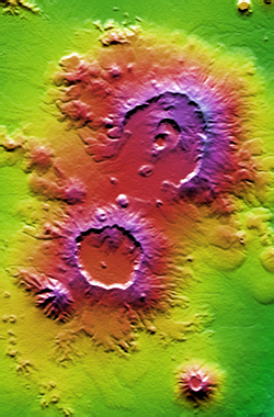
Geology
The East AfricaEast Africa
East Africa or Eastern Africa is the easterly region of the African continent, variably defined by geography or geopolitics. In the UN scheme of geographic regions, 19 territories constitute Eastern Africa:...
n tableland is continued into Ethiopia. A pioneering study of the geology of Ethiopia was W. T. Blanford's work in 1870. More recent work has focussed on the Afar Depression
Afar Depression
The Afar Triangle is a geological depression that is caused by the Afar Triple Junction which is part of the Great Rift Valley. It overlaps Eritrea, Djibouti and the entire Afar Region of Ethiopia. The Afar Triangle includes the Danakil Depression and the lowest point in Africa, Lake Asal...
, due to its importance as one of two places on Earth where a mid-ocean ridge
Mid-ocean ridge
A mid-ocean ridge is a general term for an underwater mountain system that consists of various mountain ranges , typically having a valley known as a rift running along its spine, formed by plate tectonics. This type of oceanic ridge is characteristic of what is known as an oceanic spreading...
can be studied on land (the other is Iceland
Iceland
Iceland , described as the Republic of Iceland, is a Nordic and European island country in the North Atlantic Ocean, on the Mid-Atlantic Ridge. Iceland also refers to the main island of the country, which contains almost all the population and almost all the land area. The country has a population...
).
The following formations are represented:
Sedimentary and metamorphic
- Recent: CoralCoralCorals are marine animals in class Anthozoa of phylum Cnidaria typically living in compact colonies of many identical individual "polyps". The group includes the important reef builders that inhabit tropical oceans and secrete calcium carbonate to form a hard skeleton.A coral "head" is a colony of...
, alluviumAlluviumAlluvium is loose, unconsolidated soil or sediments, eroded, deposited, and reshaped by water in some form in a non-marine setting. Alluvium is typically made up of a variety of materials, including fine particles of silt and clay and larger particles of sand and gravel...
, sandSandSand is a naturally occurring granular material composed of finely divided rock and mineral particles.The composition of sand is highly variable, depending on the local rock sources and conditions, but the most common constituent of sand in inland continental settings and non-tropical coastal... - TertiaryTertiaryThe Tertiary is a deprecated term for a geologic period 65 million to 2.6 million years ago. The Tertiary covered the time span between the superseded Secondary period and the Quaternary...
: LimestoneLimestoneLimestone is a sedimentary rock composed largely of the minerals calcite and aragonite, which are different crystal forms of calcium carbonate . Many limestones are composed from skeletal fragments of marine organisms such as coral or foraminifera....
s of Harrar - JurassicJurassicThe Jurassic is a geologic period and system that extends from about Mya to Mya, that is, from the end of the Triassic to the beginning of the Cretaceous. The Jurassic constitutes the middle period of the Mesozoic era, also known as the age of reptiles. The start of the period is marked by...
: Antalo Limestones - TriassicTriassicThe Triassic is a geologic period and system that extends from about 250 to 200 Mya . As the first period of the Mesozoic Era, the Triassic follows the Permian and is followed by the Jurassic. Both the start and end of the Triassic are marked by major extinction events...
: AdigratAdigratAdigrat is a city in the Tigray Region of Ethiopia. Located in the Misraqawi Zone at longitude and latitude with an elevation of 2457 meters above sea level, below a high ridge to the west, Adigrat is the last important Ethiopian city south of the border with Eritrea, and is considered to be a...
SandstoneSandstoneSandstone is a sedimentary rock composed mainly of sand-sized minerals or rock grains.Most sandstone is composed of quartz and/or feldspar because these are the most common minerals in the Earth's crust. Like sand, sandstone may be any colour, but the most common colours are tan, brown, yellow,...
s - Archaean: GneissGneissGneiss is a common and widely distributed type of rock formed by high-grade regional metamorphic processes from pre-existing formations that were originally either igneous or sedimentary rocks.-Etymology:...
es, schistSchistThe schists constitute a group of medium-grade metamorphic rocks, chiefly notable for the preponderance of lamellar minerals such as micas, chlorite, talc, hornblende, graphite, and others. Quartz often occurs in drawn-out grains to such an extent that a particular form called quartz schist is...
s, slatySlateSlate is a fine-grained, foliated, homogeneous metamorphic rock derived from an original shale-type sedimentary rock composed of clay or volcanic ash through low-grade regional metamorphism. The result is a foliated rock in which the foliation may not correspond to the original sedimentary layering...
rocks
Igneous
- Recent: AdenAdenAden is a seaport city in Yemen, located by the eastern approach to the Red Sea , some 170 kilometres east of Bab-el-Mandeb. Its population is approximately 800,000. Aden's ancient, natural harbour lies in the crater of an extinct volcano which now forms a peninsula, joined to the mainland by a...
Volcanic Series - Tertiary, Cretaceous: MagdalaMagdala (disambiguation)Magdala may refer to:*Magdala, a village in Galilee, related to Mary Magdalene.*Al-Majdal, Tiberias, Palestinian village in Galilee, reported to be the home of Mary Magdalene, depopulated in 1948....
group - Jurassic: Ashangi group
Archaean.--The metamorphic rocks compose the main mass of the tableland, and are exposed in every deep valley in Tigre and along the valley of the Blue Nile. Mica schists form the prevalent rocks. Hornblende schist also occur and a compact felspathic rock in the Suris defile
Defile (geography)
Defile is a geographic term for a narrow pass or gorge between mountains or hills. It has its origins as a military description of a pass through which troops can march only in a narrow column or with a narrow front...
. The foliae of the schists strike north and south.
Triassic
Triassic
The Triassic is a geologic period and system that extends from about 250 to 200 Mya . As the first period of the Mesozoic Era, the Triassic follows the Permian and is followed by the Jurassic. Both the start and end of the Triassic are marked by major extinction events...
.--In the region of Adigrat the metamorphic rocks are invariably overlain by white and brown sandstones, unfossiliferous, and attaining a maximum thickness of 300 m. They are overlain by the fossiliferous limestones of the Antalo group. Around Chelga and Adigrat coal-bearing beds occur, which Blanford suggests may be of the same age as the coal-bearing strata of India. The Adigrat Sandstone possibly represents some portion of the Karoo System
Karoo System
The Karoo System or Karoo Sequence, is a geologic system of rock formations covering 1 500 000 square km and extending from the Equator south to the Cape of Good Hope...
of South Africa.
Jurassic
Jurassic
The Jurassic is a geologic period and system that extends from about Mya to Mya, that is, from the end of the Triassic to the beginning of the Cretaceous. The Jurassic constitutes the middle period of the Mesozoic era, also known as the age of reptiles. The start of the period is marked by...
.--The fossiliferous limestones of Antalo are generally horizontal, but are in places much disturbed when interstratified with trap rocks. The fossils are all characteristic Oolite forms and include species of Hemicidaris, Pholadomya, Ceromya, Trigonia and Alaria.
Climate
The climate is temperate on the plateau and hot in the lowlands. At Addis AbabaAddis Ababa
Addis Ababa is the capital city of Ethiopia...
, which ranges from 2200 to 2600 m (7,217.8 to 8,530.2 ft), maximum temperature is 26 °C (78.8 °F) and minimum 4 °C (39.2 °F). The weather is usually sunny and dry, but the short (belg) rains occur from February to April and the big (meher) rains from mid-June to mid-September.
The climate of Ethiopia and its dependent territories varies greatly. The Somali Region
Somali Region
Somali Region ; is the eastern-most of the nine ethnic divisions of Ethiopia. It is often called Somalia, though it is not to be confused with the independent country of the same name. The capital of Somali State is Jijiga...
and the Danakil lowlands in the Afar Region have a hot, dry climate producing semi-desert conditions; the country in the lower basin of the Sobat
Sobat River
The Sobat River is a river in South Sudan, Africa. The most southerly of the great eastern tributaries of the Nile, the Sobat enters the White Nile at Doleib Hill, near the city of Malakal in the Upper Nile state of South Sudan...
is hot, swampy and malarious. But over the greater part of Ethiopia as well as the Oromia highlands the climate is very healthy and temperate. The country lies wholly within the tropics
Tropics
The tropics is a region of the Earth surrounding the Equator. It is limited in latitude by the Tropic of Cancer in the northern hemisphere at approximately N and the Tropic of Capricorn in the southern hemisphere at S; these latitudes correspond to the axial tilt of the Earth...
, but its nearness to the equator
Equator
An equator is the intersection of a sphere's surface with the plane perpendicular to the sphere's axis of rotation and containing the sphere's center of mass....
is counterbalanced by the elevation of the land. In the deep valleys of the Tekezé
Tekezé River
The Tekezé River, also known as the Takkaze River, is a major river of Ethiopia, and forms a section the westernmost border of Ethiopia and Eritrea for part of its course. The river is also known as the Setit in Eritrea, western Ethiopia, and eastern Sudan. According to materials published by the...
and Abay, and generally in places below 1200 m (3,937 ft), the conditions are tropical and diseases such as malaria
Malaria
Malaria is a mosquito-borne infectious disease of humans and other animals caused by eukaryotic protists of the genus Plasmodium. The disease results from the multiplication of Plasmodium parasites within red blood cells, causing symptoms that typically include fever and headache, in severe cases...
are prevalent. On the uplands, however, the air is cool and bracing in summer, and in winter very bleak. The mean range of temperature is between 15 to 25 °C (59 to 77 °F). On the higher mountains the climate is Alpine
Alpine climate
Alpine climate is the average weather for a region above the tree line. This climate is also referred to as mountain climate or highland climate....
in character. The atmosphere on the plateaus is exceedingly clear, so that objects are easily recognizable at great distances. In addition to the variation in climate dependent on elevation, the year may be divided into three seasons. Winter, or the cold season, lasts from October to February, and is followed by a dry hot period, which about the middle of June gives place to the rainy season. The rain is heaviest in the Tekezé basin in July and August.
In the former provinces of Gojjam
Gojjam
Gojjam was a kingdom in the north-western part of Ethiopia, with its capital city at Debre Marqos. This region is distinctive for lying entirely within the bend of the Abbay River from its outflow from Lake Tana to the Sudan...
and Welega
Welega Province
Welega was a province in the western part of Ethiopia, with its capital city at Nekemte. It was named for the Welega Oromo, who are the majority of the population within its boundaries....
heavy rains continue till the middle of September, and occasionally October is a wet month. There are also spring and winter rains; indeed rain often falls in every month of the year. But the rainy season proper, caused by the southwest monsoon, lasts from June to mid-September, and commencing in the north moves southward. In the region of the headwaters of the Sobat the rains begin earlier and last longer. The rainfall varies from about 750 mm (29.5 in) a year in Tigray
Tigray Region
Tigray Region is the northernmost of the nine ethnic regions of Ethiopia containing the homeland of the Tigray people. It was formerly known as Region 1...
and Amhara
Amhara Region
Amhara is one of the nine ethnic divisions of Ethiopia, containing the homeland of the Amhara people. Previously known as Region 3, its capital is Bahir Dar....
to over 1000 mm (39.4 in) in parts of Oromia. The rainy season is of great importance not only to Ethiopia but to the countries of the Nile valley, as the prosperity of the eastern Sudan and Egypt
Egypt
Egypt , officially the Arab Republic of Egypt, Arabic: , is a country mainly in North Africa, with the Sinai Peninsula forming a land bridge in Southwest Asia. Egypt is thus a transcontinental country, and a major power in Africa, the Mediterranean Basin, the Middle East and the Muslim world...
is largely dependent upon the rainfall. A season of light rain may be sufficient for the needs of Ethiopia, but there is little surplus water to find its way to the Nile; and a shortness of rain means a low Nile, as practically all the flood water of that river is derived from the Ethiopian tributaries.
Flora and fauna
As in a day's journey the traveller may pass from tropical to almost Alpine conditions of climate, so great also is the range of the flora and fauna.In the valleys and lowlands the vegetation is dense, but the general appearance of the plateaus is of a comparatively bare country with trees and bushes thinly scattered over it. The glens and ravines on the hillside are often thickly wooded, and offer a delightful contrast to the open downs.
These conditions are particularly characteristic of the northern regions; in the south the vegetation on the uplands is more luxuriant. Among the many varieties of trees and plants found are the date palm, mimosa
Mimosa
Mimosa is a genus of about 400 species of herbs and shrubs, in the subfamily Mimosoideae of the legume family Fabaceae. The generic name is derived from the Greek word μιμος , meaning "mimic."...
, wild olive
Olive
The olive , Olea europaea), is a species of a small tree in the family Oleaceae, native to the coastal areas of the eastern Mediterranean Basin as well as northern Iran at the south end of the Caspian Sea.Its fruit, also called the olive, is of major agricultural importance in the...
, giant sycamore
Sycamore
Sycamore is a name which is applied at various times and places to three very different types of trees, but with somewhat similar leaf forms....
s, juniper
Juniper
Junipers are coniferous plants in the genus Juniperus of the cypress family Cupressaceae. Depending on taxonomic viewpoint, there are between 50-67 species of juniper, widely distributed throughout the northern hemisphere, from the Arctic, south to tropical Africa in the Old World, and to the...
s and laurels, the myrrh
Myrrh
Myrrh is the aromatic oleoresin of a number of small, thorny tree species of the genus Commiphora, which grow in dry, stony soil. An oleoresin is a natural blend of an essential oil and a resin. Myrrh resin is a natural gum....
and other gum trees (gnarled and stunted, these flourish most on the eastern foothills), a magnificent pine (the Natal yellow pine, which resists the attacks of the white ant), the fig
Ficus
Ficus is a genus of about 850 species of woody trees, shrubs, vines, epiphytes, and hemiepiphyte in the family Moraceae. Collectively known as fig trees or figs, they are native throughout the tropics with a few species extending into the semi-warm temperate zone. The Common Fig Ficus is a genus of...
, orange
Orange (fruit)
An orange—specifically, the sweet orange—is the citrus Citrus × sinensis and its fruit. It is the most commonly grown tree fruit in the world....
, lime, pomegranate
Pomegranate
The pomegranate , Punica granatum, is a fruit-bearing deciduous shrub or small tree growing between five and eight meters tall.Native to the area of modern day Iran, the pomegranate has been cultivated in the Caucasus since ancient times. From there it spread to Asian areas such as the Caucasus as...
, peach
Peach
The peach tree is a deciduous tree growing to tall and 6 in. in diameter, belonging to the subfamily Prunoideae of the family Rosaceae. It bears an edible juicy fruit called a peach...
, apricot
Apricot
The apricot, Prunus armeniaca, is a species of Prunus, classified with the plum in the subgenus Prunus. The native range is somewhat uncertain due to its extensive prehistoric cultivation.- Description :...
, banana
Banana
Banana is the common name for herbaceous plants of the genus Musa and for the fruit they produce. Bananas come in a variety of sizes and colors when ripe, including yellow, purple, and red....
, and other fruit trees; the grape
Grape
A grape is a non-climacteric fruit, specifically a berry, that grows on the perennial and deciduous woody vines of the genus Vitis. Grapes can be eaten raw or they can be used for making jam, juice, jelly, vinegar, wine, grape seed extracts, raisins, molasses and grape seed oil. Grapes are also...
vine (rare), blackberry
Blackberry
The blackberry is an edible fruit produced by any of several species in the Rubus genus of the Rosaceae family. The fruit is not a true berry; botanically it is termed an aggregate fruit, composed of small drupelets. The plants typically have biennial canes and perennial roots. Blackberries and...
, and raspberry
Raspberry
The raspberry or hindberry is the edible fruit of a multitude of plant species in the genus Rubus, most of which are in the subgenus Idaeobatus; the name also applies to these plants themselves...
; the cotton
Cotton
Cotton is a soft, fluffy staple fiber that grows in a boll, or protective capsule, around the seeds of cotton plants of the genus Gossypium. The fiber is almost pure cellulose. The botanical purpose of cotton fiber is to aid in seed dispersal....
and indigo Plants, and occasionally the sugar cane. There are in the south large forests of valuable timber trees; and the coffee plant is indigenous in the Kaffa
Kaffa
Kaffa is the name of several geographical entities:*Kingdom of Kaffa, ancient Kingdom of the Sidamo people.*Kaffa, former province in Ethiopia.*Kaffa people, an ethnic group in Ethiopia....
country, whence it takes its name. Many kinds of grass
Poaceae
The Poaceae is a large and nearly ubiquitous family of flowering plants. Members of this family are commonly called grasses, although the term "grass" is also applied to plants that are not in the Poaceae lineage, including the rushes and sedges...
es and flower
Flower
A flower, sometimes known as a bloom or blossom, is the reproductive structure found in flowering plants . The biological function of a flower is to effect reproduction, usually by providing a mechanism for the union of sperm with eggs...
s abound. Large areas are covered by the kosso, a hardy member of the rose
Rose
A rose is a woody perennial of the genus Rosa, within the family Rosaceae. There are over 100 species. They form a group of erect shrubs, and climbing or trailing plants, with stems that are often armed with sharp prickles. Flowers are large and showy, in colours ranging from white through yellows...
family, which grows from 2.5 to 3 m (8.2 to 9.8 ft) high and has abundant pendent red blossoms. The flowers and the leaves of this plant are highly prized for medicinal purposes. The fruit of the hurarina, a tree found almost exclusively in Shoa, yields a black grain highly esteemed as a spice
Spice
A spice is a dried seed, fruit, root, bark, or vegetative substance used in nutritionally insignificant quantities as a food additive for flavor, color, or as a preservative that kills harmful bacteria or prevents their growth. It may be used to flavour a dish or to hide other flavours...
. On the tableland a great variety of cereal
Cereal
Cereals are grasses cultivated for the edible components of their grain , composed of the endosperm, germ, and bran...
s and vegetable
Vegetable
The noun vegetable usually means an edible plant or part of a plant other than a sweet fruit or seed. This typically means the leaf, stem, or root of a plant....
s are cultivated. A fibrous plant, known as the sansevieria
Sansevieria
Sansevieria is a genus of about 70 species of flowering plants, whose common names include mother-in-law's tongue, devil's tongue, jinn's tongue, bow string hemp, snake plant and snake tongue. It is often included in the genus Dracaena; in the APG III classification system, both genera are placed...
, grows in a wild state in the semi-desert regions of the north and south-east.
In addition to the domestic animals enumerated below the fauna is very varied. Elephant
Elephant
Elephants are large land mammals in two extant genera of the family Elephantidae: Elephas and Loxodonta, with the third genus Mammuthus extinct...
can be found in certain low-lying districts, especially in the Sobat valley. The hippopotamus
Hippopotamus
The hippopotamus , or hippo, from the ancient Greek for "river horse" , is a large, mostly herbivorous mammal in sub-Saharan Africa, and one of only two extant species in the family Hippopotamidae After the elephant and rhinoceros, the hippopotamus is the third largest land mammal and the heaviest...
and crocodile
Crocodile
A crocodile is any species belonging to the family Crocodylidae . The term can also be used more loosely to include all extant members of the order Crocodilia: i.e...
inhabit the larger rivers flowing west, but are not found in the Hawash, in which, however, otter
Otter
The Otters are twelve species of semi-aquatic mammals which feed on fish and shellfish, and also other invertebrates, amphibians, birds and small mammals....
s of large size are plentiful. Lion
Lion
The lion is one of the four big cats in the genus Panthera, and a member of the family Felidae. With some males exceeding 250 kg in weight, it is the second-largest living cat after the tiger...
s abound in the low countries and in Somaliland. In central Ethiopia the lion is no longer found except occasionally in the river valleys. Leopard
Leopard
The leopard , Panthera pardus, is a member of the Felidae family and the smallest of the four "big cats" in the genus Panthera, the other three being the tiger, lion, and jaguar. The leopard was once distributed across eastern and southern Asia and Africa, from Siberia to South Africa, but its...
s, both spotted and black, are numerous and often of great size; hyena
Hyena
Hyenas or Hyaenas are the animals of the family Hyaenidae of suborder feliforms of the Carnivora. It is the fourth smallest biological family in the Carnivora , and one of the smallest in the mammalia...
s are found everywhere and are hardy and fierce; the lynx
Lynx
A lynx is any of the four Lynx genus species of medium-sized wildcats. The name "lynx" originated in Middle English via Latin from Greek word "λύγξ", derived from the Indo-European root "*leuk-", meaning "light, brightness", in reference to the luminescence of its reflective eyes...
, wolf, wild dog
Dog
The domestic dog is a domesticated form of the gray wolf, a member of the Canidae family of the order Carnivora. The term is used for both feral and pet varieties. The dog may have been the first animal to be domesticated, and has been the most widely kept working, hunting, and companion animal in...
and jackal
Jackal
Although the word jackal has been historically used to refer to many small- to medium-sized species of the wolf genus of mammals, Canis, today it most properly and commonly refers to three species: the black-backed jackal and the side-striped jackal of sub-Saharan Africa, and the golden jackal of...
are also common. Boar
Boar
Wild boar, also wild pig, is a species of the pig genus Sus, part of the biological family Suidae. The species includes many subspecies. It is the wild ancestor of the domestic pig, an animal with which it freely hybridises...
s and badgers are more rarely seen. The giraffe
Giraffe
The giraffe is an African even-toed ungulate mammal, the tallest of all extant land-living animal species, and the largest ruminant...
is found in the western districts, the zebra
Zebra
Zebras are several species of African equids united by their distinctive black and white stripes. Their stripes come in different patterns unique to each individual. They are generally social animals that live in small harems to large herds...
and wild ass frequent the lower plateaus and the rocky hills of the north. There are large herds of buffalo
Bubalus
Bubalus is a genus of bovines, whose English name is buffalo. Species that belong to this genus are:* Subgenus Bubalus** Water Buffalo, Bubalus bubalis*** Carabao, Bubalus bubalis carabanesis...
and antelope
Antelope
Antelope is a term referring to many even-toed ungulate species indigenous to various regions in Africa and Eurasia. Antelopes comprise a miscellaneous group within the family Bovidae, encompassing those old-world species that are neither cattle, sheep, buffalo, bison, nor goats...
, and gazelle
Gazelle
A gazelle is any of many antelope species in the genus Gazella, or formerly considered to belong to it. Six species are included in two genera, Eudorcas and Nanger, which were formerly considered subgenera...
s of many varieties and in great numbers are met with in most parts of the country. Among the varieties are the greater and lesser kudu
Kudu
The kudus are two species of antelope of the genus Tragelaphus:*Lesser Kudu, Tragelaphus imberbis*Greater Kudu, Tragelaphus strepsiceros- Etymology :...
(both rather rare); the duiker
Duiker
A duiker is any of about 21 small to medium-sized antelope species from the subfamily Cephalophinae native to Sub-Saharan Africa.Duikers are shy and elusive creatures with a fondness for dense cover; most are forest dwellers and even the species living in more open areas are quick to disappear...
, gemsbuck, hartebeest
Hartebeest
The hartebeest is a grassland antelope found in West Africa, East Africa and Southern Africa. It is one of the three species classified in the genus Alcelaphus....
, gerenuk
Gerenuk
The Gerenuk , also known as the Waller's Gazelle, is a long-necked species of antelope found in dry bushy scrub and steppe in East Africa, from Somalia and eastern Ethiopia through northern and eastern Kenya to northeastern Tanzania...
(the most common—it has long thin legs and a camel-like neck); klipspringer
Klipspringer
The Klipspringer, Oreotragus oreotragus, is a small species of African antelope.-Name:The word klipspringer literally means "rock jumper" in Afrikaans/Dutch...
, found on the high plateaus as well as in the lower districts; and the dik-dik
Dik-dik
A dik-dik, pronounced "dĭk’ dĭk", is a small antelope in the Genus Madoqua that lives in the bushes of eastern and southern Africa. Dik-diks stand 30–40 cm at the shoulder, are 50–70 cm long, weigh 3–6 kg and can live for up to 10 years...
, the smallest of the antelope
Antelope
Antelope is a term referring to many even-toed ungulate species indigenous to various regions in Africa and Eurasia. Antelopes comprise a miscellaneous group within the family Bovidae, encompassing those old-world species that are neither cattle, sheep, buffalo, bison, nor goats...
s, its weight rarely exceeding 5 kg (11 lb), common in the low countries and the foothills. The civet
Civet
The family Viverridae is made up of around 30 species of medium-sized mammal, including all of the genets, the binturong, most of the civets, and the two African linsangs....
is found in many parts of Ethiopia, but chiefly in the Galla
Galla
Galla can refer to:* A derogatory name for the Oromo people of Ethiopia* Galla * Galla * Galla Placidia, daughter of Theodosius I* Galla of Rome, 6th-century saint* Gallu, a Mesopotamian demon...
regions. Squirrel
Squirrel
Squirrels belong to a large family of small or medium-sized rodents called the Sciuridae. The family includes tree squirrels, ground squirrels, chipmunks, marmots , flying squirrels, and prairie dogs. Squirrels are indigenous to the Americas, Eurasia, and Africa and have been introduced to Australia...
s and hare
Hare
Hares and jackrabbits are leporids belonging to the genus Lepus. Hares less than one year old are called leverets. Four species commonly known as types of hare are classified outside of Lepus: the hispid hare , and three species known as red rock hares .Hares are very fast-moving...
s are numerous, as are several kinds of monkey
Monkey
A monkey is a primate, either an Old World monkey or a New World monkey. There are about 260 known living species of monkey. Many are arboreal, although there are species that live primarily on the ground, such as baboons. Monkeys are generally considered to be intelligent. Unlike apes, monkeys...
s, notably the guereza, gelada
Gelada
The gelada , sometimes called the gelada baboon, is a species of Old World monkey found only in the Ethiopian Highlands, with large populations in the Semien Mountains...
, guenon
Guenon
The guenons are the genus Cercopithecus of Old World monkeys. Not all the members of this genus have the word "guenon" in their common names, and because of changes in scientific classification, some monkeys in other genera may have common names that do include the word "guenon"...
and dog-faced baboon
Baboon
Baboons are African and Arabian Old World monkeys belonging to the genus Papio, part of the subfamily Cercopithecinae. There are five species, which are some of the largest non-hominoid members of the primate order; only the mandrill and the drill are larger...
. They range from the tropical lowlands to heights of 3000 m (9,843 ft).
Bird
Bird
Birds are feathered, winged, bipedal, endothermic , egg-laying, vertebrate animals. Around 10,000 living species and 188 families makes them the most speciose class of tetrapod vertebrates. They inhabit ecosystems across the globe, from the Arctic to the Antarctic. Extant birds range in size from...
s are very numerous, and many of them remarkable for the
beauty of their plumage. Great numbers of eagle
Eagle
Eagles are members of the bird family Accipitridae, and belong to several genera which are not necessarily closely related to each other. Most of the more than 60 species occur in Eurasia and Africa. Outside this area, just two species can be found in the United States and Canada, nine more in...
s, vulture
Vulture
Vulture is the name given to two groups of convergently evolved scavenging birds, the New World Vultures including the well-known Californian and Andean Condors, and the Old World Vultures including the birds which are seen scavenging on carcasses of dead animals on African plains...
s, hawk
Hawk
The term hawk can be used in several ways:* In strict usage in Australia and Africa, to mean any of the species in the subfamily Accipitrinae, which comprises the genera Accipiter, Micronisus, Melierax, Urotriorchis and Megatriorchis. The large and widespread Accipiter genus includes goshawks,...
s, bustards and other birds of prey are met with; and partridge
Partridge
Partridges are birds in the pheasant family, Phasianidae. They are a non-migratory Old World group.These are medium-sized birds, intermediate between the larger pheasants and the smaller quails. Partridges are native to Europe, Asia, Africa, and the Middle East...
s, duck
Duck
Duck is the common name for a large number of species in the Anatidae family of birds, which also includes swans and geese. The ducks are divided among several subfamilies in the Anatidae family; they do not represent a monophyletic group but a form taxon, since swans and geese are not considered...
, teal
Teal
Teal may mean:* Teal , a medium greenish-blue color* Various ducks:** Baikal Teal, Anas formosa** Black Teal, Aythya novaeseelandiae** Blue-winged Teal, Anas discors** Brown Teal, Anas aucklandica** Campbell Teal Anas nesiotis...
, guineafowl
Guineafowl
The guineafowl are a family of birds in the Galliformes order, although some authorities include the guineafowl as a subfamily, Numidinae, of the family Phasianidae...
, sandgrouse
Sandgrouse
The sandgrouse are a family, Pteroclididae, of 16 bird species, the only living members of the order Pteroclidiformes. They are restricted to treeless open country in the Old World, such as plains and semi-deserts. They are distributed across northern, southern and eastern Africa as well as...
, curlew
Curlew
The curlews , genus Numenius, are a group of eight species of birds, characterised by long, slender, downcurved bills and mottled brown plumage. They are one of the most ancient lineages of scolopacid waders, together with the godwits which look similar but have straight bills...
s, woodcock
Woodcock
The woodcocks are a group of seven or eight very similar living species of wading birds in the genus Scolopax. Only two woodcocks are widespread, the others being localized island endemics. Most are found in the Northern Hemisphere but a few range into Wallacea...
, snipe
Snipe
A snipe is any of about 25 wading bird species in three genera in the family Scolopacidae. They are characterized by a very long, slender bill and crypsis plumage. The Gallinago snipes have a nearly worldwide distribution, the Lymnocryptes Jack Snipe is restricted to Asia and Europe and the...
, pigeons, thrushes and swallows are very plentiful. A fine variety of ostrich
Ostrich
The Ostrich is one or two species of large flightless birds native to Africa, the only living member of the genus Struthio. Some analyses indicate that the Somali Ostrich may be better considered a full species apart from the Common Ostrich, but most taxonomists consider it to be a...
is commonly found. Among the birds prized for their plumage are the marabout, crane
Crane (bird)
Cranes are a family, Gruidae, of large, long-legged and long-necked birds in the order Gruiformes. There are fifteen species of crane in four genera. Unlike the similar-looking but unrelated herons, cranes fly with necks outstretched, not pulled back...
, heron
Heron
The herons are long-legged freshwater and coastal birds in the family Ardeidae. There are 64 recognised species in this family. Some are called "egrets" or "bitterns" instead of "heron"....
, blacks bird, parrot
Parrot
Parrots, also known as psittacines , are birds of the roughly 372 species in 86 genera that make up the order Psittaciformes, found in most tropical and subtropical regions. The order is subdivided into three families: the Psittacidae , the Cacatuidae and the Strigopidae...
, jay
Jay
The jays are several species of medium-sized, usually colorful and noisy, passerine birds in the crow family Corvidae. The names jay and magpie are somewhat interchangeable, and the evolutionary relationships are rather complex...
and hummingbird
Hummingbird
Hummingbirds are birds that comprise the family Trochilidae. They are among the smallest of birds, most species measuring in the 7.5–13 cm range. Indeed, the smallest extant bird species is a hummingbird, the 5-cm Bee Hummingbird. They can hover in mid-air by rapidly flapping their wings...
s of extraordinary brilliance,
Among insect
Insect
Insects are a class of living creatures within the arthropods that have a chitinous exoskeleton, a three-part body , three pairs of jointed legs, compound eyes, and two antennae...
s the most numerous and useful is the bee
Bee
Bees are flying insects closely related to wasps and ants, and are known for their role in pollination and for producing honey and beeswax. Bees are a monophyletic lineage within the superfamily Apoidea, presently classified by the unranked taxon name Anthophila...
, honey
Honey
Honey is a sweet food made by bees using nectar from flowers. The variety produced by honey bees is the one most commonly referred to and is the type of honey collected by beekeepers and consumed by humans...
everywhere constituting an important part of the food of the inhabitants. Of an opposite class is the locust
Locust
Locusts are the swarming phase of short-horned grasshoppers of the family Acrididae. These are species that can breed rapidly under suitable conditions and subsequently become gregarious and migratory...
. There are thousands of varieties of butterflies
Butterfly
A butterfly is a mainly day-flying insect of the order Lepidoptera, which includes the butterflies and moths. Like other holometabolous insects, the butterfly's life cycle consists of four parts: egg, larva, pupa and adult. Most species are diurnal. Butterflies have large, often brightly coloured...
and other insects. Snake
Snake
Snakes are elongate, legless, carnivorous reptiles of the suborder Serpentes that can be distinguished from legless lizards by their lack of eyelids and external ears. Like all squamates, snakes are ectothermic, amniote vertebrates covered in overlapping scales...
s are not numerous, but several species are venom
Venom
Venom is the general term referring to any variety of toxins used by certain types of animals that inject it into their victims by the means of a bite or a sting...
ous.
Natural resources and land use
Ethiopia has small reserves of gold, platinum, copper, potash, and natural gas. It has extensive hydropower potential.Of the total land area, about 20 percent is under cultivation, although the amount of potentially arable land is larger. Only about 10 to 15 percent of the land area is presently covered by forest as a result of rapid deforestation
Ethiopian deforestation
Deforestation in Ethiopia is due to locals clearing forests for their personal needs, such as for fuel, hunting, agriculture, housing development, and at times for religious reasons. The main causes of deforestation in Ethiopia are shifting agriculture, livestock production and fuel in drier areas...
during the last 30 years. Of the remainder, a large portion is used as pasturage. Some land is too rugged, dry, or infertile for agriculture or any other use.
Disputed territory
The border between Ethiopia and Eritrea has never been precisely demarcated. Between 1998 and 2000, the two countries fought a war over the issue, which involves quite small enclaves along the northern segment of their border, including the tiny village of BadmeBadme
Badme is a town in the Horn of Africa and the focus of a territorial dispute between Eritrea and Ethiopia. It is claimed by both Eritrea, which considers Badme to be a part of Gash-Barka Zone, and Ethiopia, which considers Badme part of the Mirabawi Zone of the Tigray Region. This dispute was the...
and the enclave of the Irob people
Irob people
The Irob people are an ethnic group who occupy a predominantly highland, mountainous area by the same name in northeastern Tigray Region, Ethiopia. They speak the Saho language, are Christians , and mainly agriculturalists...
. In 2002 an international boundary commission delimited the border. Although both nations agreed to accept its decision, Ethiopia has refused to accept the commission’s findings in full, much to the consternation of the Eritrean government. The central section of Ethiopia’s border with Somalia also has never been fully demarcated and is only provisional. Questions remain about the precise location of small parcels along the border with Sudan as well.
Statistics
Location- Eastern AfricaAfricaAfrica is the world's second largest and second most populous continent, after Asia. At about 30.2 million km² including adjacent islands, it covers 6% of the Earth's total surface area and 20.4% of the total land area...
, west of SomaliaSomaliaSomalia , officially the Somali Republic and formerly known as the Somali Democratic Republic under Socialist rule, is a country located in the Horn of Africa. Since the outbreak of the Somali Civil War in 1991 there has been no central government control over most of the country's territory...
Geographic coordinates:
- 8°00′N 38°00′E
Map references:
- Africa
Area:
- Total: 1,127,127 km²
- Land: 1,119,683 km²
- Water: 7,444 km²
Land boundaries:
- Total: 5,311 km
- Border countries: DjiboutiDjiboutiDjibouti , officially the Republic of Djibouti , is a country in the Horn of Africa. It is bordered by Eritrea in the north, Ethiopia in the west and south, and Somalia in the southeast. The remainder of the border is formed by the Red Sea and the Gulf of Aden at the east...
337 km, EritreaEritreaEritrea , officially the State of Eritrea, is a country in the Horn of Africa. Eritrea derives it's name from the Greek word Erethria, meaning 'red land'. The capital is Asmara. It is bordered by Sudan in the west, Ethiopia in the south, and Djibouti in the southeast...
912 km, KenyaKenyaKenya , officially known as the Republic of Kenya, is a country in East Africa that lies on the equator, with the Indian Ocean to its south-east...
830 km, SomaliaSomaliaSomalia , officially the Somali Republic and formerly known as the Somali Democratic Republic under Socialist rule, is a country located in the Horn of Africa. Since the outbreak of the Somali Civil War in 1991 there has been no central government control over most of the country's territory...
1,626 km, South SudanSouth SudanSouth Sudan , officially the Republic of South Sudan, is a landlocked country located in the Sahel region of northeastern Africa. It is also part of the North Africa UN sub-region. Its current capital is Juba, which is also its largest city; the capital city is planned to be moved to the more...
883 km and SudanSudanSudan , officially the Republic of the Sudan , is a country in North Africa, sometimes considered part of the Middle East politically. It is bordered by Egypt to the north, the Red Sea to the northeast, Eritrea and Ethiopia to the east, South Sudan to the south, the Central African Republic to the...
723 km
Coastline:
- 0 km (landlocked)
Maritime claims:
- None (landlocked)
Climate:
- Tropical monsoon with wide topographic-induced variation
Terrain:
- High plateau with central mountain range divided by Great Rift Valley
Elevation extremes:
- Lowest point: DanakilAfar DepressionThe Afar Triangle is a geological depression that is caused by the Afar Triple Junction which is part of the Great Rift Valley. It overlaps Eritrea, Djibouti and the entire Afar Region of Ethiopia. The Afar Triangle includes the Danakil Depression and the lowest point in Africa, Lake Asal...
, -125 m - Highest point: Ras Dejen, 4,533 m
Natural resources:
- Small reserves of goldGoldGold is a chemical element with the symbol Au and an atomic number of 79. Gold is a dense, soft, shiny, malleable and ductile metal. Pure gold has a bright yellow color and luster traditionally considered attractive, which it maintains without oxidizing in air or water. Chemically, gold is a...
, platinumPlatinumPlatinum is a chemical element with the chemical symbol Pt and an atomic number of 78. Its name is derived from the Spanish term platina del Pinto, which is literally translated into "little silver of the Pinto River." It is a dense, malleable, ductile, precious, gray-white transition metal...
, copperCopperCopper is a chemical element with the symbol Cu and atomic number 29. It is a ductile metal with very high thermal and electrical conductivity. Pure copper is soft and malleable; an exposed surface has a reddish-orange tarnish...
, potashPotashPotash is the common name for various mined and manufactured salts that contain potassium in water-soluble form. In some rare cases, potash can be formed with traces of organic materials such as plant remains, and this was the major historical source for it before the industrial era...
, natural gasNatural gasNatural gas is a naturally occurring gas mixture consisting primarily of methane, typically with 0–20% higher hydrocarbons . It is found associated with other hydrocarbon fuel, in coal beds, as methane clathrates, and is an important fuel source and a major feedstock for fertilizers.Most natural...
, hydropower
Land use:
- Arable land: 12%
- Permanent crops: 1%
- Permanent pastures: 40%
- Forests and woodland: 25%
- Other: 22% (1993 est.)
Irrigated land:
- 1,900 km² (1993 est.)
Natural hazards:
- Geologically active Great Rift Valley susceptible to earthquakes, volcanic eruptions; frequent droughts
Environment - current issues:
- Deforestation; overgrazing; soil erosion; desertification
Environment - international agreements:
- Party to: BiodiversityBiodiversityBiodiversity is the degree of variation of life forms within a given ecosystem, biome, or an entire planet. Biodiversity is a measure of the health of ecosystems. Biodiversity is in part a function of climate. In terrestrial habitats, tropical regions are typically rich whereas polar regions...
, Climate ChangeUnited Nations Framework Convention on Climate ChangeThe United Nations Framework Convention on Climate Change is an international environmental treaty produced at the United Nations Conference on Environment and Development , informally known as the Earth Summit, held in Rio de Janeiro from June 3 to 14, 1992...
, DesertificationDesertificationDesertification is the degradation of land in drylands. Caused by a variety of factors, such as climate change and human activities, desertification is one of the most significant global environmental problems.-Definitions:...
, Endangered SpeciesEndangered speciesAn endangered species is a population of organisms which is at risk of becoming extinct because it is either few in numbers, or threatened by changing environmental or predation parameters...
, Ozone Layer Protection - Signed, but not ratified: Environmental Modification, Law of the SeaLaw of the seaLaw of the sea may refer to:* United Nations Convention on the Law of the Sea* Admiralty law* The Custom of the Sea...
, Nuclear Test Ban
Geography - note:
- LandlockedLandlockedA landlocked country is a country entirely enclosed by land, or whose only coastlines lie on closed seas. There are 48 landlocked countries in the world, including partially recognized states...
- entire coastline along the Red Sea was lost with the de jure independence of Eritrea on 24 May 1993
See also
- EthiopiaEthiopiaEthiopia , officially known as the Federal Democratic Republic of Ethiopia, is a country located in the Horn of Africa. It is the second-most populous nation in Africa, with over 82 million inhabitants, and the tenth-largest by area, occupying 1,100,000 km2...
- Extreme points of EthiopiaExtreme points of EthiopiaThe extreme points of Ethiopia include the coordinates that are further north, south, east or west than any other location in Ethiopia; and the highest and the lowest elevations in the country...
- List of lakes in Ethiopia
- List of mountains in Ethiopia
- List of rivers of Ethiopia
- List of volcanoes in Ethiopia
- Ilemi TriangleIlemi TriangleThe Ilemi Triangle is an area of disputed land in East Africa. Arbitrarily defined, it measures between 10,320 and 14,000 square kilometers . Named after Anuak chief Ilemi Akwon, the territory is claimed by South Sudan and Kenya and borders Ethiopia...
- Mandera triangleMandera triangleThe Mandera triangle is a geographical region in Eastern Africa where the countries of Kenya, Ethiopia, and Somalia meet. The tri-border region is centered on the city of Mandera in Kenya's North Eastern Province and corresponds with the Juba and Shabelle river basins.The residents of the area are...
External links
- Maps of Ethiopia - Perry-Castañeda Library Map Collection, University of Texas at AustinUniversity of Texas at AustinThe University of Texas at Austin is a state research university located in Austin, Texas, USA, and is the flagship institution of the The University of Texas System. Founded in 1883, its campus is located approximately from the Texas State Capitol in Austin...
- The soil maps of Ethiopia, EuDASMEuropean Digital Archive on Soil Maps of the WorldEuropean Digital Archive on Soil Maps is a digital inventory of the maps holding valuable information pertaining to soil that are highly demanded in various environmental assessment studies focusing on policy issues...
- The mapping of Ethiopia Ethiopia-United States Mapping MissionEthiopia-United States Mapping MissionThe Ethiopia-United States Mapping Mission, also known as the Ethi-U.S. Mapping Mission, was an operation undertaken by the United States Army during the 1960s to provide up-to-date topographic map coverage of the entire country of Ethiopia...
web site - ETHIOPIA TOPOGRAPHIC MAPS East View CartographicEast View CartographicEast View Cartographic is a leading American provider of geospatial information, and of cartographic and GIS services, much of it outsourced to offshore companies...
web site - Ethiopia's government mapping agency, Ethiopian Mapping AuthorityEthiopian Mapping AuthorityThe Ethiopian Mapping Authority is a branch of the Ethiopian government, a department within the Ministry of Interior, that is responsible for cartographic mapping and remote sensing activities in Ethiopia...
web site