

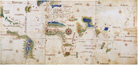
Cantino planisphere
Encyclopedia
Ferrara
Ferrara is a city and comune in Emilia-Romagna, northern Italy, capital city of the Province of Ferrara. It is situated 50 km north-northeast of Bologna, on the Po di Volano, a branch channel of the main stream of the Po River, located 5 km north...
, who successfully smuggled it from Portugal
Portugal
Portugal , officially the Portuguese Republic is a country situated in southwestern Europe on the Iberian Peninsula. Portugal is the westernmost country of Europe, and is bordered by the Atlantic Ocean to the West and South and by Spain to the North and East. The Atlantic archipelagos of the...
to Italy
Italy
Italy , officially the Italian Republic languages]] under the European Charter for Regional or Minority Languages. In each of these, Italy's official name is as follows:;;;;;;;;), is a unitary parliamentary republic in South-Central Europe. To the north it borders France, Switzerland, Austria and...
in 1502. The map is particularly notable for portraying a fragmentary record of the Brazil
Brazil
Brazil , officially the Federative Republic of Brazil , is the largest country in South America. It is the world's fifth largest country, both by geographical area and by population with over 192 million people...
ian coast, discovered in 1500 by the Portuguese explorer Pedro Álvares Cabral
Pedro Álvares Cabral
Pedro Álvares Cabral was a Portuguese noble, military commander, navigator and explorer regarded as the discoverer of Brazil. Cabral conducted the first substantial exploration of the northeast coast of South America and claimed it for Portugal. While details of Cabral's early life are sketchy, it...
, and for depicting the African coast of the Atlantic and Indian Oceans with a remarkable accuracy and detail.
History
In the beginning of the 16th century, LisbonLisbon
Lisbon is the capital city and largest city of Portugal with a population of 545,245 within its administrative limits on a land area of . The urban area of Lisbon extends beyond the administrative city limits with a population of 3 million on an area of , making it the 9th most populous urban...
was a buzzing metropolis where people from diverse backgrounds came in search of work, glory or fortune. There were also many undercover agents looking for the secrets brought by the Portuguese voyages to remote lands. Among them was Alberto Cantino, who was sent to Portugal by the Duke of Ferrara, with the formal intention of horse trading
Horse trading
In the original sense, Horse trading is the buying and selling of horses, also called "Horse Dealing". Due to the difficulties in evaluating the merits of a horse offered for sale, the selling of horses offered great opportunities for dishonesty...
, while secretly collecting information on the Portuguese Discoveries. Cantino’s diligence is shown in two of his letters to the Duke, dated from 17th and 18 October 1501, where he describes, amongst other things, hearing Gaspar Corte-Real
Gaspar Corte-Real
Gaspar Corte-Real was a Portuguese explorer.He was the youngest of three sons of João Vaz Corte-Real, also a Portuguese explorer, and had accompanied his father on his expeditions to North America...
detailing his latest voyage to Newfoundland (Terra Nova) to King Manuel I of Portugal
Manuel I of Portugal
Manuel I , the Fortunate , 14th king of Portugal and the Algarves was the son of Infante Ferdinand, Duke of Viseu, , by his wife, Infanta Beatrice of Portugal...
.
Most probably the Cantino Planisphere is a copy of the official prototype existing at Casa da Índia
Casa da Índia
Casa da Índia was the Portuguese organization that managed all overseas territories during the heyday of the Portuguese Empire in the 16th century. It was both the central authority for managing all aspects of overseas trade, the central shipment point and clearing house...
(The House of India), in Lisbon
Lisbon
Lisbon is the capital city and largest city of Portugal with a population of 545,245 within its administrative limits on a land area of . The urban area of Lisbon extends beyond the administrative city limits with a population of 3 million on an area of , making it the 9th most populous urban...
, where the new discoveries made by the Portuguese were recorded, held in secret and named the Padrão Real
Padrão Real
The Padrão Real was a secret master Portuguese map produced and maintained by the Portuguese government organization, the Casa da Índia, where the new discoveries made by the Portuguese were recorded in secret...
. It is conjectured that Cantino was able to bribe a certain Portuguese government mapmaker with 12 golden ducat
Ducat
The ducat is a gold coin that was used as a trade coin throughout Europe before World War I. Its weight is 3.4909 grams of .986 gold, which is 0.1107 troy ounce, actual gold weight...
s (a considerable amount for the time) to copy this map for him, between December 1501 and October 1502. From a letter signed by Cantino, it’s thought that he sent the map to Duke Ferrara on the 19th of November, 1502. An Italian inscription in the back of the map reads: “Carta de navigar per le Isole nouam trovate in le parte de India: dono Alberto Cantino al S. Duca Hercole”. As a result, this historic cartography work, from an anonymous Portuguese author, was named Cantino Planisphere (or Cantino World Map) – Carta del Cantino (in Italian).
While it enlightened the Italians to many new territories as of yet unknown to them, it was obsolete within months due to subsequent mapping voyages by the Portuguese. Nevertheless, its importance to the Portuguese-Italian trade relations should not be understated; this map provided the Italians with knowledge of Brazil's coastline and that of much of the Atlantic
Atlantic Ocean
The Atlantic Ocean is the second-largest of the world's oceanic divisions. With a total area of about , it covers approximately 20% of the Earth's surface and about 26% of its water surface area...
Coast of South America
South America
South America is a continent situated in the Western Hemisphere, mostly in the Southern Hemisphere, with a relatively small portion in the Northern Hemisphere. The continent is also considered a subcontinent of the Americas. It is bordered on the west by the Pacific Ocean and on the north and east...
long before other nations even knew South America extended so far to the south. It also supplied great details of the Indian Ocean
Indian Ocean
The Indian Ocean is the third largest of the world's oceanic divisions, covering approximately 20% of the water on the Earth's surface. It is bounded on the north by the Indian Subcontinent and Arabian Peninsula ; on the west by eastern Africa; on the east by Indochina, the Sunda Islands, and...
. The geographical information given on the Cantino map was copied into the Italian-made Canerio (or Caveri) map
Caverio map
The Caverio Map is a map drawn by Nicolay de Caveri, circa 1505.-History:Currently at Bibliothèque Nationale de France in Paris. First described in 1890 and reproduced two years later. This undated map was one of the primary sources used to make the Waldseemüller map in 1507...
shortly after the Cantino map arrived in Italy and the Canerio, in turn, became the primary source for the design of the newly discovered western lands on the highly influential wall map of the world produced by Martin Waldseemüller
Martin Waldseemüller
Martin Waldseemüller was a German cartographer...
in 1507 under the auspices of Rene, Duke of Lorraine.
This old map, made-up by 6 glued parchment
Parchment
Parchment is a thin material made from calfskin, sheepskin or goatskin, often split. Its most common use was as a material for writing on, for documents, notes, or the pages of a book, codex or manuscript. It is distinct from leather in that parchment is limed but not tanned; therefore, it is very...
sheets, was kept in the Ducal Library, Ferrara
Ferrara
Ferrara is a city and comune in Emilia-Romagna, northern Italy, capital city of the Province of Ferrara. It is situated 50 km north-northeast of Bologna, on the Po di Volano, a branch channel of the main stream of the Po River, located 5 km north...
, for about 90 years, until Pope Clement VIII
Pope Clement VIII
Pope Clement VIII , born Ippolito Aldobrandini, was Pope from 30 January 1592 to 3 March 1605.-Cardinal:...
transferred it to another palace in Modena
Modena
Modena is a city and comune on the south side of the Po Valley, in the Province of Modena in the Emilia-Romagna region of Italy....
, Italy. More than two centuries later, in 1859, the palace was ransacked and the Cantino Map lost. It was found by Giuseppe Boni, Director of the Biblioteca Estense, in that same year, in a butcher’s store in Modena. The Cantino world map can currently be found in Modena
Modena
Modena is a city and comune on the south side of the Po Valley, in the Province of Modena in the Emilia-Romagna region of Italy....
, Italy, at the Biblioteca Estense
Biblioteca Estense
The Biblioteca Estense , established in Modena in the seventeenth century, is one of the most important libraries in Italy. The library is located in the Palazzo del Musei, Off Via Emilia, at Piazza Sant'Agostino 48.- Collection :...
.
Construction
The construction of the compass line grid (or rhumb lines) in the Cantino planisphere uses two focal points (most portolan chartPortolan chart
Portolan charts are navigational maps based on realistic descriptions of harbours and coasts. They were first made in the 14th century in Italy, Portugal and Spain...
s use only one). The construction is based on two focal circles ("wheels with spokes") - the western circle is centered on the Cape Verde
Cape Verde
The Republic of Cape Verde is an island country, spanning an archipelago of 10 islands located in the central Atlantic Ocean, 570 kilometres off the coast of Western Africa...
islands, the eastern focal circle is placed in India. Each focal circle has an implied outer circle (more precisely a hexadecagon
Hexadecagon
In mathematics, a hexadecagon is a polygon with 16 sides and 16 vertices.- Regular hexadecagon :A regular hexadecagon is constructible with a compass and straightedge....
with 16 vertices), and the two together cover most of the map. The circumference of each outer circle is ringed with sixteen equidistant 32-point compass rose
Compass rose
A compass rose, sometimes called a windrose, is a figure on a compass, map, nautical chart or monument used to display the orientation of the cardinal directions — North, East, South and West - and their intermediate points. It is also the term for the graduated markings found on the traditional...
s - sometimes an elaborately drawn compass rose, sometimes left as a mere confluence of rhumb lines (when an illustration would conflict with the coastal details). The western and eastern outer circles are tangent to each other at a rose in central Africa. The map also has several scattered scale bars to help measure distances (including an atypical diagonal scale bar for the coast of Mozambique).
Illustrations are few, but elaborate. Two cities are grandly depicted - Venice
Venice
Venice is a city in northern Italy which is renowned for the beauty of its setting, its architecture and its artworks. It is the capital of the Veneto region...
and Jerusalem. There is also an elaborate depiction of the Portuguese castle of São Jorge da Mina (Elmina Castle
Elmina Castle
Elmina Castle was erected by Portugal in 1482 as São Jorge da Mina Castle, also known simply as Mina or Feitoria da Mina) in present-day Elmina, Ghana . It was the first trading post built on the Gulf of Guinea, so is the oldest European building in existence below the Sahara...
, on the Gold Coast
Portuguese Gold Coast
The Portuguese Gold Coast was a Portuguese colony on the West African Gold Coast on the Gulf of Guinea.-History:The Portuguese established the following settlements on the Gold Coast from January 21, 1482:...
of west Africa
West Africa
West Africa or Western Africa is the westernmost region of the African continent. Geopolitically, the UN definition of Western Africa includes the following 16 countries and an area of approximately 5 million square km:-Flags of West Africa:...
), flanked by two African towns. Other illustrations include a lion-shaped mountain representing the Sierra Leone
Sierra Leone
Sierra Leone , officially the Republic of Sierra Leone, is a country in West Africa. It is bordered by Guinea to the north and east, Liberia to the southeast, and the Atlantic Ocean to the west and southwest. Sierra Leone covers a total area of and has an estimated population between 5.4 and 6.4...
mountain range, the Alexandria lighthouse (laid horizontal), the mythical Mountains of the Moon
Mountains of the Moon (Africa)
The term Mountains of the Moon or Montes Lunae referred to a mountain range in central Africa that is the source of the White Nile.- Ancient testimony :...
(legendary source of the Nile River) in central Africa, and either the Table Mountain
Table Mountain
Table Mountain is a flat-topped mountain forming a prominent landmark overlooking the city of Cape Town in South Africa, and is featured in the flag of Cape Town and other local government insignia. It is a significant tourist attraction, with many visitors using the cableway or hiking to the top...
or Drakensberg
Drakensberg
The Drakensberg is the highest mountain range in Southern Africa, rising to in height. In Zulu, it is referred to as uKhahlamba , and in Sesotho as Maluti...
range in South Africa. Along the central African coast are the various cross stone markers (padrões
Padrão
A padrão was a large stone cross inscribed with the coat of arms of Portugal that was placed as part of a land claim by numerous Portuguese explorers during the Portuguese Age of Discovery...
) erected by Diogo Cão
Diogo Cão
Diogo Cão was a Portuguese explorer and one of the most remarkable navigators of the Age of Discovery, who made two voyages sailing along the west coast of Africa to Namibia in the 1480s.-Early life and family:...
and Bartholomew Dias in the 1480s.
In north Africa, there is the "Montes Claros" in the usual place of the Atlas mountains
Atlas Mountains
The Atlas Mountains is a mountain range across a northern stretch of Africa extending about through Morocco, Algeria, and Tunisia. The highest peak is Toubkal, with an elevation of in southwestern Morocco. The Atlas ranges separate the Mediterranean and Atlantic coastlines from the Sahara Desert...
, the legend below on the left reading that "this is the land of King Organo, whose king is very noble and very rich", and to the right that this is the "land of the King of Nubia, the king of which is continuously making war on Prester John
Prester John
The legends of Prester John were popular in Europe from the 12th through the 17th centuries, and told of a Christian patriarch and king said to rule over a Christian nation lost amidst the Muslims and pagans in the Orient. Written accounts of this kingdom are variegated collections of medieval...
and is a moor and a great enemy of Christians".
Discoveries
The Cantino map contains evident corrections, made either in the course of 1501-02, while it was being composed by the anonymous Portuguese cartographer, or shortly after it was delivered in November 1502, possibly by an unknown Italian draftsman. The coast of Brazil, in particular, seems to have adjustments.See also
- Ancient world mapsAncient world mapsEarly world maps cover depictions of the world from the Iron Age to the Age of Discovery and the emergence of modern geography during the early modern period.-Babylonian Imago Mundi Early world maps cover depictions of the world from the Iron Age to the Age of Discovery and the emergence of modern...
- Portuguese discoveries
- World mapWorld mapA world map is a map of the surface of the Earth, which may be made using any of a number of different map projections. A map projection is any method of representing the surface of a sphere or other three-dimensional body on a plane....