

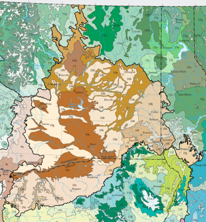
Columbia Plateau (ecoregion)
Encyclopedia
The Columbia Plateau ecoregion is a Level III ecoregion designated by the United States Environmental Protection Agency
(EPA) in the U.S. states of Oregon
and Washington, with small areas over the Washington state border in Idaho
. The ecoregion
extends across a wide swath of the Columbia River Basin from The Dalles, Oregon
to Lewiston, Idaho
to Okanogan, Washington
near the Canadian border. It includes nearly 500 miles (804.7 km) of the Columbia River
, as well as the lower reaches of major tributaries such as the Snake
and Yakima
rivers and the associated drainage basin
s. It is named for the Columbia River Plateau
, a flood basalt
plateau
formed by the Columbia River Basalt Group
during the late Miocene
and early Pliocene
. The arid
sagebrush steppe
and grassland
s of the region are flanked by moister, predominantly forest
ed, mountain
ous ecoregions on all sides. The underlying basalt
is up to 2 miles (3 km) thick and partially covered by thick loess
desposits
. Where precipitation
amounts are sufficient, the deep loess soil
s have been extensively cultivated for wheat
. Water from the Columbia River is subject to resource allocation debates involving fisheries, navigation
, hydropower
, recreation
, and irrigation
, and the Columbia Basin Project
has dramatically converted much of the region to agricultural use.
The Columbia Plateau ecoregion has been subdivided into at least fourteen Level IV ecoregions, as described below. The EPA has not yet published an Ecoregions of Washington poster similar to the informational posters for Oregon and Idaho, and the Washington information presented here is not as complete as the information about the other two states.
s and Channeled Scablands
of Washington carved out by the cataclysmic Missoula floods
, from Wenatchee
to Spokane
, including public land within the Lake Roosevelt National Recreation Area
and Wenatchee National Forest
.
, including public land within the Turnbull National Wildlife Refuge
and the Juniper Dunes Wilderness.
who originally inhabited the area, is characterized by a nearly level to rolling, treeless plateau, underlain by basalt and veneered with loess deposits. Elevation varies from 1,000 to 3,200 feet (300 to 980 m). Glacial features such as patterned ground
are common. Areas with thick loess deposits are farmed for dryland
winter wheat
or irrigated alfalfa
and barley
. Rangeland
dominates more rugged areas where loess deposits are thinner or nonexistent. Mean annual precipitation is 9 to 15 inches (230 to 380 mm) and increases with elevation. In uncultivated areas, moisture levels are generally high enough to support grasslands of bluebunch wheatgrass
, Sandberg bluegrass
, and Idaho fescue, without associated sagebrush
, which is more common in the Pleistocene Lake Basins. Stiff sagebrush may be found on very shallow soils. Alien
cheatgrass covers broad areas. The region covers 3712 square miles (9,614 km²) in Eastern Oregon
, including the Umatilla Indian Reservation
and agricultural areas south of the Columbia River.
.
lakes that were created by flood waters from glacial lake
s Missoula and Columbia. In Oregon, the flood waters accumulated from the eastern entrance of the Columbia River Gorge
upstream to the Wallula Gap
to form ancient Lake Condon
. Elevation varies from 300 to 1,200 feet (90 to 370 m). Today, the region is the driest and warmest part of the Columbia Plateau, with mean annual precipitation varying from 7 to 10 inches (180 to 250 mm). Major irrigation projects provide Columbia River water to the region, allowing the conversion of large areas into agriculture. Where present, native vegetation
consists of needle-and-thread, Indian ricegrass
, bluebunch wheatgrass, Sandberg bluegrass, and basin big sagebrush. Alien cheatgrass covers broad areas. The largest of the Columbia Plateau subregions, the Pleistocene Lake Basins covers 1407 square miles (3,644 km²) in Eastern Oregon
and larger areas in Washington, encompassing lower elevations throughout the Mid-Columbia Basin. It includes part of the Yakama Indian Reservation
, as well as public lands within the Umatilla
, Cold Springs
, McNary
, and Columbia
national wildlife refuge
s, the Hanford Nuclear Site, and the Hanford Reach National Monument
.
. Livestock
grazing
and farming have eliminated much of the original plant cover. Nevertheless, the Dissected Loess Uplands is not as suited to farming as neighboring regions because it has thinner soils. The Dissected Loess Uplands covers 224 square miles (580 km²) in western Idaho and larger areas in southeastern Washington, south of the Snake River between Dayton
and Lewiston
, including part of the Nez Perce Indian Reservation.
people who originally inhabited the area, consists of unforested anticlinal ridges
composed of layer upon layer of basalt many thousands of feet thick. Elevation varies from 1,000 to 3,500 feet (300 to 1070 m). Loess blankets the south-facing slopes and supports dryland wheat farming. Steep, rocky north-facing slopes are commonly used for livestock grazing. The region receives an average of 10 to 12 inches (250 to 300 mm) of rain per year. Sagebrush and bunchgrass associations dominate plant assemblages outside of heavily farmed or grazed areas, with needle-and-thread, bluebunch wheatgrass, Sandberg bluegrass, Wyoming big sagebrush, and basin big sagebrush. Alien cheatgrass covers broad areas. The region covers 109 square miles (282 km²) in Oregon and much larger areas in Washington, extending from the Horse Heaven Hills
in the south to the Kittitas Valley in the north, including parts of Yakama Indian Reservation
, Hanford Reach National Monument, Wenas Wildlife Area
, and the Yakima Training Center
.
known as the Palouse Hills, after the Palouse River
that runs through them and the Palus tribe
who originally inhabited the area. Elevation varies from 2,500 to 3,000 feet (760 to 910 m). Mountain-fed perennial stream
s occur, and intermittent, loess-bottomed streams rise within the region. The soils are rich in organic matter
and very productive, supporting extensive wheat farming, but they are easily eroded
. Dry stream channels may be tilled
. The region supports fescue-wheatgrass, fescue-snowberry, and fescue-hawthorn
associations, as well as ponderosa pine
savanna
and open ponderosa pine and Douglas-fir
forests. The region covers 453 square miles (1,173 km²) along the Idaho border, including parts of the St. Joe National Forest
and the Coeur d'Alene Indian Reservation, and larger areas in Whitman
and Spokane
Counties, Washington.
, with perennial streams fed by snow melt from the adjacent high mountains. Elevation varies from 1,500 to 3,000 feet (460 to 910 m). Moisture levels are high enough to support grasslands of Idaho fescue, Sandberg bluegrass, and bluebunch wheatgrass, but the region is dominated by non-irrigated winter wheat, barley, alfalfa, and green pea farming on the highly-productive, loess-rich soils. The region covers 146 square miles (378 km²) in Oregon and a contiguous area in Washington, in a narrow band from Pendleton
to Dayton, including part of the Umatilla Indian Reservation.
of downstream canyon reaches. The region covers 725 square miles (1,878 km²) in Idaho, on the Nez Perce Indian Reservation and surrounding areas.
Rivers. Deeply cut into the basalt, the canyons fragment a lightly populated portion of the Umatilla Plateau. Canyon depths up to 2000 feet (609.6 m) create drier conditions than on the plateau above. Sparse bunchgrasses, Wyoming big sagebrush, and cheatgrass grow on the rocky, colluvial soil
. Riparian vegetation in narrow reaches is often limited to a band of white alder
at the water line, with some mockorange, western clematis, and chokecherry
; broader floodplain
s and gravel bars are dominated by introduced species, such as reed canarygrass, sweetclover, and teasel. The rivers support chinook salmon
and steelhead runs. The region covers 674 square miles (1,746 km²) in Oregon, along the lower reaches of the Deschutes and John Day rivers and their tributaries.
Rivers. Canyon depths exceed 1400 feet (426.7 m) and create drier conditions than in neighboring regions; mean annual precipitation is only 12 to 25 inches (300 to 640 mm). Outside of towns and transportation corridors, the canyons provide good habitat
for bighorn sheep
and game birds, with grasslands of bluebunch wheatgrass, Idaho fescue, bluegrass, and Wyoming big sagebrush. The region covers 80 square miles (207 km²) in Idaho and slightly larger areas in Washington, along the lower reaches of the Snake and Clearwater rivers and their tributaries.
and Methow
Rivers and their tributaries in northeastern Washington, including land managed by the Okanogan National Forest
. The extension northwards into Canada of this ecoregion comprises the Okanagan Valley of British Columbia
.
. Slopes are rolling to very steep. Elevation varies from 1,600 to 4,400 feet (490 to 1,340 m). The hills and uplands are covered with Idaho fescue, bluebunch wheatgrass, and Sandberg bluegrass. Near the Blue Mountains, some north-facing slopes have Douglas-fir and ponderosa pine, with snowberry, pinegrass
, and ninebark. The region is mostly used as rangeland because it lacks the thick, arable
loess deposits that cover the agricultural Umatilla Plateau. Scablands, composed of arrays of earth mounds surrounded by rock polygons, are relics of Pleistocene glacial periods. The region covers 743 square miles (1,924 km²) in Eastern Oregon, in a narrow band along the northern edge of the Umatilla National Forest
, mostly outside the national forest's boundaries.
United States Environmental Protection Agency
The U.S. Environmental Protection Agency is an agency of the federal government of the United States charged with protecting human health and the environment, by writing and enforcing regulations based on laws passed by Congress...
(EPA) in the U.S. states of Oregon
Oregon
Oregon is a state in the Pacific Northwest region of the United States. It is located on the Pacific coast, with Washington to the north, California to the south, Nevada on the southeast and Idaho to the east. The Columbia and Snake rivers delineate much of Oregon's northern and eastern...
and Washington, with small areas over the Washington state border in Idaho
Idaho
Idaho is a state in the Rocky Mountain area of the United States. The state's largest city and capital is Boise. Residents are called "Idahoans". Idaho was admitted to the Union on July 3, 1890, as the 43rd state....
. The ecoregion
Ecoregion
An ecoregion , sometimes called a bioregion, is an ecologically and geographically defined area that is smaller than an ecozone and larger than an ecosystem. Ecoregions cover relatively large areas of land or water, and contain characteristic, geographically distinct assemblages of natural...
extends across a wide swath of the Columbia River Basin from The Dalles, Oregon
The Dalles, Oregon
The Dalles is the largest city and county seat of Wasco County, Oregon, United States. The name of the city comes from the French word dalle The Dalles is the largest city and county seat of Wasco County, Oregon, United States. The name of the city comes from the French word dalle The Dalles is...
to Lewiston, Idaho
Lewiston, Idaho
Lewiston is a city in and also the county seat of Nez Perce County in the Pacific Northwest state of Idaho. It is the second-largest city in the northern Idaho region, behind Coeur d'Alene and ninth-largest in the state. Lewiston is the principal city of the Lewiston, ID - Clarkston, WA...
to Okanogan, Washington
Okanogan, Washington
Okanogan is a town in Okanogan County, Washington, United States. The population was 2,552 at the 2010 census. It is the county seat of Okanogan County.It has a small commuter airfield, Okanogan Legion Airport - with one paved runway of in length....
near the Canadian border. It includes nearly 500 miles (804.7 km) of the Columbia River
Columbia River
The Columbia River is the largest river in the Pacific Northwest region of North America. The river rises in the Rocky Mountains of British Columbia, Canada, flows northwest and then south into the U.S. state of Washington, then turns west to form most of the border between Washington and the state...
, as well as the lower reaches of major tributaries such as the Snake
Snake River
The Snake is a major river of the greater Pacific Northwest in the United States. At long, it is the largest tributary of the Columbia River, the largest North American river that empties into the Pacific Ocean...
and Yakima
Yakima River
The Yakima River is a tributary of the Columbia River in south central and eastern Washington State, named for the indigenous Yakama people. The length of the river from headwaters to mouth is , with an average drop of .-Course:...
rivers and the associated drainage basin
Drainage basin
A drainage basin is an extent or an area of land where surface water from rain and melting snow or ice converges to a single point, usually the exit of the basin, where the waters join another waterbody, such as a river, lake, reservoir, estuary, wetland, sea, or ocean...
s. It is named for the Columbia River Plateau
Columbia River Plateau
The Columbia Plateau is a geologic and geographic region that lies across parts of the U.S. states of Washington, Oregon, and Idaho. It is a wide flood basalt plateau between the Cascade Range and the Rocky Mountains, cut through by the Columbia River...
, a flood basalt
Flood basalt
A flood basalt or trap basalt is the result of a giant volcanic eruption or series of eruptions that coats large stretches of land or the ocean floor with basalt lava. Flood basalts have occurred on continental scales in prehistory, creating great plateaus and mountain ranges...
plateau
Plateau
In geology and earth science, a plateau , also called a high plain or tableland, is an area of highland, usually consisting of relatively flat terrain. A highly eroded plateau is called a dissected plateau...
formed by the Columbia River Basalt Group
Columbia River Basalt Group
The Columbia River Basalt Group is a large igneous province that lies across parts of the Western United States. It is found in the U.S. states of Washington, Oregon, Idaho, Nevada, and California...
during the late Miocene
Miocene
The Miocene is a geological epoch of the Neogene Period and extends from about . The Miocene was named by Sir Charles Lyell. Its name comes from the Greek words and and means "less recent" because it has 18% fewer modern sea invertebrates than the Pliocene. The Miocene follows the Oligocene...
and early Pliocene
Pliocene
The Pliocene Epoch is the period in the geologic timescale that extends from 5.332 million to 2.588 million years before present. It is the second and youngest epoch of the Neogene Period in the Cenozoic Era. The Pliocene follows the Miocene Epoch and is followed by the Pleistocene Epoch...
. The arid
Arid
A region is said to be arid when it is characterized by a severe lack of available water, to the extent of hindering or even preventing the growth and development of plant and animal life...
sagebrush steppe
Sagebrush steppe
The sagebrush steppe is a type of shrub-steppe, which is a dry-xeric environment and plant community found in the Western United States and western Canada...
and grassland
Grassland
Grasslands are areas where the vegetation is dominated by grasses and other herbaceous plants . However, sedge and rush families can also be found. Grasslands occur naturally on all continents except Antarctica...
s of the region are flanked by moister, predominantly forest
Forest
A forest, also referred to as a wood or the woods, is an area with a high density of trees. As with cities, depending where you are in the world, what is considered a forest may vary significantly in size and have various classification according to how and what of the forest is composed...
ed, mountain
Mountain
Image:Himalaya_annotated.jpg|thumb|right|The Himalayan mountain range with Mount Everestrect 58 14 160 49 Chomo Lonzorect 200 28 335 52 Makalurect 378 24 566 45 Mount Everestrect 188 581 920 656 Tibetan Plateaurect 250 406 340 427 Rong River...
ous ecoregions on all sides. The underlying basalt
Basalt
Basalt is a common extrusive volcanic rock. It is usually grey to black and fine-grained due to rapid cooling of lava at the surface of a planet. It may be porphyritic containing larger crystals in a fine matrix, or vesicular, or frothy scoria. Unweathered basalt is black or grey...
is up to 2 miles (3 km) thick and partially covered by thick loess
Loess
Loess is an aeolian sediment formed by the accumulation of wind-blown silt, typically in the 20–50 micrometre size range, twenty percent or less clay and the balance equal parts sand and silt that are loosely cemented by calcium carbonate...
desposits
Deposition (geology)
Deposition is the geological process by which material is added to a landform or land mass. Fluids such as wind and water, as well as sediment flowing via gravity, transport previously eroded sediment, which, at the loss of enough kinetic energy in the fluid, is deposited, building up layers of...
. Where precipitation
Precipitation (meteorology)
In meteorology, precipitation In meteorology, precipitation In meteorology, precipitation (also known as one of the classes of hydrometeors, which are atmospheric water phenomena is any product of the condensation of atmospheric water vapor that falls under gravity. The main forms of precipitation...
amounts are sufficient, the deep loess soil
Soil
Soil is a natural body consisting of layers of mineral constituents of variable thicknesses, which differ from the parent materials in their morphological, physical, chemical, and mineralogical characteristics...
s have been extensively cultivated for wheat
Wheat
Wheat is a cereal grain, originally from the Levant region of the Near East, but now cultivated worldwide. In 2007 world production of wheat was 607 million tons, making it the third most-produced cereal after maize and rice...
. Water from the Columbia River is subject to resource allocation debates involving fisheries, navigation
Navigation
Navigation is the process of monitoring and controlling the movement of a craft or vehicle from one place to another. It is also the term of art used for the specialized knowledge used by navigators to perform navigation tasks...
, hydropower
Hydropower
Hydropower, hydraulic power, hydrokinetic power or water power is power that is derived from the force or energy of falling water, which may be harnessed for useful purposes. Since ancient times, hydropower has been used for irrigation and the operation of various mechanical devices, such as...
, recreation
Recreation
Recreation is an activity of leisure, leisure being discretionary time. The "need to do something for recreation" is an essential element of human biology and psychology. Recreational activities are often done for enjoyment, amusement, or pleasure and are considered to be "fun"...
, and irrigation
Irrigation
Irrigation may be defined as the science of artificial application of water to the land or soil. It is used to assist in the growing of agricultural crops, maintenance of landscapes, and revegetation of disturbed soils in dry areas and during periods of inadequate rainfall...
, and the Columbia Basin Project
Columbia Basin Project
The Columbia Basin Project in Central Washington, USA, is the irrigation network that the Grand Coulee Dam makes possible. It is the largest water reclamation project in the United States, supplying irrigation water to over of the large project area, all of which was originally intended to be...
has dramatically converted much of the region to agricultural use.
The Columbia Plateau ecoregion has been subdivided into at least fourteen Level IV ecoregions, as described below. The EPA has not yet published an Ecoregions of Washington poster similar to the informational posters for Oregon and Idaho, and the Washington information presented here is not as complete as the information about the other two states.
Level IV ecoregions
Channeled Scablands (10a)
The Channeled Scablands ecoregion contains the couleeCoulee
Coulee is applied rather loosely to different landforms, all of which refer to a kind of valley or drainage zone.The word coulee comes from the Canadian French coulée, from French word couler meaning "to flow"....
s and Channeled Scablands
Channeled scablands
The Channeled Scablands are a unique geological erosion feature in the U.S. state of Washington. They were created by the cataclysmic Missoula Floods that swept periodically across eastern Washington and down the Columbia River Plateau during the Pleistocene epoch. Geologist J Harlen Bretz coined...
of Washington carved out by the cataclysmic Missoula floods
Missoula Floods
The Missoula Floods refer to the cataclysmic floods that swept periodically across eastern Washington and down the Columbia River Gorge at the end of the last ice age. The glacial flood events have been researched since the 1920s...
, from Wenatchee
Wenatchee, Washington
Wenatchee is located in North Central Washington and is the largest city and county seat of Chelan County, Washington, United States. The population within the city limits in 2010 was 31,925...
to Spokane
Spokane, Washington
Spokane is a city located in the Northwestern United States in the state of Washington. It is the largest city of Spokane County of which it is also the county seat, and the metropolitan center of the Inland Northwest region...
, including public land within the Lake Roosevelt National Recreation Area
Lake Roosevelt National Recreation Area
Lake Roosevelt National Recreation Area is a U.S. National Recreation Area of the National Park Service that encompasses the long Franklin D. Roosevelt Lake between Grand Coulee Dam and Northport, Washington, in eastern Washington state. It is a popular boating, fishing, hunting, camping, and...
and Wenatchee National Forest
Wenatchee National Forest
Wenatchee National Forest is a U.S. National Forest located in Washington. With an area of 1,735,394 acres , it extends about 137 miles along the eastern slopes of the Cascade Range of Washington, USA from Okanogan National Forest to Gifford Pinchot National Forest...
.
Loess Islands (10b)
The Loess Islands ecoregion consists of large pockets of thick loess deposits surrounded by the Channeled Scablands throughout Eastern WashingtonEastern Washington
Eastern Washington is the portion of the U.S. state of Washington east of the Cascade Range. The region contains the city of Spokane , the Tri-Cities, the Columbia River and the Grand Coulee Dam, the Hanford Nuclear Reservation and the fertile farmlands of the Yakima Valley and the...
, including public land within the Turnbull National Wildlife Refuge
Turnbull National Wildlife Refuge
The Turnbull National Wildlife Refuge was established in 1937 by an Executive Order of President Franklin D. Roosevelt is located six miles south of Cheney, Washington on the eastern edge of the Columbia Basin, in Spokane County in northeastern Washington. Turnbull NWR encompasses approximately ...
and the Juniper Dunes Wilderness.
Umatilla Plateau (10c)
The Umatilla Plateau ecoregion, named for the UmatillaUmatilla (tribe)
The Umatilla are a Sahaptin-speaking Native American group living on the Umatilla Indian Reservation, who traditionally inhabited the Columbia Plateau region of the northwestern United States....
who originally inhabited the area, is characterized by a nearly level to rolling, treeless plateau, underlain by basalt and veneered with loess deposits. Elevation varies from 1,000 to 3,200 feet (300 to 980 m). Glacial features such as patterned ground
Patterned ground
Patterned ground is a term used to describe the distinct, and often symmetrical geometric shapes formed by ground material in periglacial regions...
are common. Areas with thick loess deposits are farmed for dryland
Dryland farming
Dryland farming is an agricultural technique for non-irrigated cultivation of drylands.-Locations:Dryland farming is used in the Great Plains, the Palouse plateau of Eastern Washington, and other arid regions of North America, the Middle East and in other grain growing regions such as the steppes...
winter wheat
Winter wheat
Winter wheat is a type of wheat that is planted from September to December in the Northern Hemisphere. Winter wheat sprouts before freezing occurs, then becomes dormant until the soil warms in the spring. Winter wheat needs a few weeks of cold before being able to flower, however persistent snow...
or irrigated alfalfa
Alfalfa
Alfalfa is a flowering plant in the pea family Fabaceae cultivated as an important forage crop in the US, Canada, Argentina, France, Australia, the Middle East, South Africa, and many other countries. It is known as lucerne in the UK, France, Australia, South Africa and New Zealand, and known as...
and barley
Barley
Barley is a major cereal grain, a member of the grass family. It serves as a major animal fodder, as a base malt for beer and certain distilled beverages, and as a component of various health foods...
. Rangeland
Rangeland
Rangelands are vast natural landscapes in the form of grasslands, shrublands, woodlands, wetlands, and deserts. Types of rangelands include tallgrass and shortgrass prairies, desert grasslands and shrublands, woodlands, savannas, chaparrals, steppes, and tundras...
dominates more rugged areas where loess deposits are thinner or nonexistent. Mean annual precipitation is 9 to 15 inches (230 to 380 mm) and increases with elevation. In uncultivated areas, moisture levels are generally high enough to support grasslands of bluebunch wheatgrass
Bluebunch wheatgrass
Pseudoroegneria spicata is a species of grass known by the common name Bluebunch Wheatgrass. This native western North American perennial bunchgrass is known by the scientific synonyms Elymus spicatus and Agropyron spicatum. The grass can be found from Alaska to Texas. It occurs in many types of...
, Sandberg bluegrass
Poa
Poa is a genus of about 500 species of grasses, native to the temperate regions of both hemispheres. Common names include meadow-grass , bluegrass , tussock , and speargrass. "Poa" is Greek for fodder...
, and Idaho fescue, without associated sagebrush
Sagebrush
Sagebrush is a common name of a number of shrubby plant species in the genus Artemisia native to western North America;Or, the sagebrush steppe ecoregion, having one or more kinds of sagebrush, bunchgrasses and others;...
, which is more common in the Pleistocene Lake Basins. Stiff sagebrush may be found on very shallow soils. Alien
Introduced species
An introduced species — or neozoon, alien, exotic, non-indigenous, or non-native species, or simply an introduction, is a species living outside its indigenous or native distributional range, and has arrived in an ecosystem or plant community by human activity, either deliberate or accidental...
cheatgrass covers broad areas. The region covers 3712 square miles (9,614 km²) in Eastern Oregon
Eastern Oregon
Eastern Oregon is the eastern part of the U.S. state of Oregon. It is not an officially recognized geographic entity, thus the boundaries of the region vary according to context. It is sometimes understood to include only the eight easternmost counties in the state; in other contexts, it includes...
, including the Umatilla Indian Reservation
Umatilla Indian Reservation
The Umatilla Indian Reservation is an Indian reservation in eastern Oregon in the United States, mostly located in Umatilla County, with a very small part extending south into Union County...
and agricultural areas south of the Columbia River.
Okanogan Drift Hills (10d)
The Okanogan Drift Hills ecoregion is located in Douglas and Okanogan Counties, Washington, including part of the Colville Indian ReservationColville Indian Reservation
The Colville Indian Reservation is an Indian reservation in the north-central part of the U.S. state of Washington, inhabited and managed by the Confederated Tribes of the Colville Reservation, which is recognized by the United States of America as an American Indian Tribe...
.
Pleistocene Lake Basins (10e)
The Pleistocene Lake Basins ecoregion is a nearly level to undulating lake plain that contained vast temporary PleistocenePleistocene
The Pleistocene is the epoch from 2,588,000 to 11,700 years BP that spans the world's recent period of repeated glaciations. The name pleistocene is derived from the Greek and ....
lakes that were created by flood waters from glacial lake
Glacial lake
A glacial lake is a lake with origins in a melted glacier. Near the end of the last glacial period, roughly 10,000 years ago, glaciers began to retreat. A retreating glacier often left behind large deposits of ice in hollows between drumlins or hills. As the ice age ended, these melted to create...
s Missoula and Columbia. In Oregon, the flood waters accumulated from the eastern entrance of the Columbia River Gorge
Columbia River Gorge
The Columbia River Gorge is a canyon of the Columbia River in the Pacific Northwest of the United States. Up to deep, the canyon stretches for over as the river winds westward through the Cascade Range forming the boundary between the State of Washington to the north and Oregon to the south...
upstream to the Wallula Gap
Wallula Gap
Wallula Gap is a large water gap of the Columbia River through basalt anticlines in the Columbia River Basin in the U.S. state of Washington, just south of the confluence of the Walla Walla and Columbia rivers...
to form ancient Lake Condon
Lake Condon
Lake Condon was a temporary lake in the Pacific Northwest region of North America, formed periodically by the Missoula Floods from 15,000 to 13,000 BC....
. Elevation varies from 300 to 1,200 feet (90 to 370 m). Today, the region is the driest and warmest part of the Columbia Plateau, with mean annual precipitation varying from 7 to 10 inches (180 to 250 mm). Major irrigation projects provide Columbia River water to the region, allowing the conversion of large areas into agriculture. Where present, native vegetation
Native plant
Native plant is a term to describe plants endemic or naturalized to a given area in geologic time.This includes plants that have developed, occur naturally, or existed for many years in an area...
consists of needle-and-thread, Indian ricegrass
Indian ricegrass
Oryzopsis hymenoides is a perennial cool-season bunchgrass. It is native to western North America east of the Cascades from British Columbia and Alberta south to southern California, northeastern Mexico, and Texas...
, bluebunch wheatgrass, Sandberg bluegrass, and basin big sagebrush. Alien cheatgrass covers broad areas. The largest of the Columbia Plateau subregions, the Pleistocene Lake Basins covers 1407 square miles (3,644 km²) in Eastern Oregon
Eastern Oregon
Eastern Oregon is the eastern part of the U.S. state of Oregon. It is not an officially recognized geographic entity, thus the boundaries of the region vary according to context. It is sometimes understood to include only the eight easternmost counties in the state; in other contexts, it includes...
and larger areas in Washington, encompassing lower elevations throughout the Mid-Columbia Basin. It includes part of the Yakama Indian Reservation
Yakama Indian Reservation
The Yakama Indian Reservation is a United States Indian reservation located on the east side of the Cascade Mountains in southern Washington. It is the homeland of the Yakama tribe of Native Americans....
, as well as public lands within the Umatilla
Umatilla National Wildlife Refuge
The Umatilla National Wildlife Refuge is located on and around the Columbia River about northwest of Hermiston, Oregon and includes in Oregon, and in Washington. It was established in 1969 to help mitigate habitat lose due to the flooding that occurred following the construction of the John Day...
, Cold Springs
Cold Springs National Wildlife Refuge
Cold Springs National Wildlife Refuge is a National Wildlife Refuge located northeast of Hermiston and south of the Columbia River in Umatilla County, Oregon; The refuge was established in 1909 as a preserve and breeding ground for native birds. It consists of diverse wetland habitats...
, McNary
McNary National Wildlife Refuge
Few areas in North America support waterfowl populations in the extraordinary numbers found within McNary National Wildlife Refuge. Visitors enjoy spectacular concentrations of Canada geese, mallards, and other waterfowl. More than half the mallards in the Pacific Flyway overwinter at some time in...
, and Columbia
Columbia National Wildlife Refuge
Columbia National Wildlife Refuge is a scenic mixture of rugged cliffs, canyons, lakes, and sagebrush grasslands. Formed by fire, ice, floods, and volcanic tempest, carved by periods of extreme violence of natural forces, the refuge lies in the middle of the Drumheller Channeled Scablands of...
national wildlife refuge
National Wildlife Refuge
National Wildlife Refuge is a designation for certain protected areas of the United States managed by the United States Fish and Wildlife Service. The National Wildlife Refuge System is the world's premiere system of public lands and waters set aside to conserve America's fish, wildlife and plants...
s, the Hanford Nuclear Site, and the Hanford Reach National Monument
Hanford Reach National Monument
The Hanford Reach National Monument is a national monument in the U.S. State of Washington. It was created in 2000, mostly from the former security buffer surrounding the Hanford Nuclear Reservation...
.
Dissected Loess Uplands (10f)
The Dissected Loess Uplands ecoregion consists of disjunct rolling hills and flat plateau remnants cut by the Lower Snake and Clearwater Canyons. Elevation varies from 1,500 to 3,600 feet (460 to 1,100 m). Pure grasslands dominate lower elevations, with bluebunch wheatgrass, Idaho fescue, and Sandberg bluegrass. Mountain brush grows on north facing slopes and higher, moister sites, with snowberry and wild roseRosa acicularis
Rosa acicularis, also known as the prickly wild rose, the prickly rose, the bristly rose and the Arctic rose, is a species of wild rose with a Holarctic distribution in northern regions of Asia, Europe, and North America....
. Livestock
Livestock
Livestock refers to one or more domesticated animals raised in an agricultural setting to produce commodities such as food, fiber and labor. The term "livestock" as used in this article does not include poultry or farmed fish; however the inclusion of these, especially poultry, within the meaning...
grazing
Grazing
Grazing generally describes a type of feeding, in which a herbivore feeds on plants , and also on other multicellular autotrophs...
and farming have eliminated much of the original plant cover. Nevertheless, the Dissected Loess Uplands is not as suited to farming as neighboring regions because it has thinner soils. The Dissected Loess Uplands covers 224 square miles (580 km²) in western Idaho and larger areas in southeastern Washington, south of the Snake River between Dayton
Dayton, Washington
Dayton is a city in and the county seat of Columbia County, Washington, United States. The population was 2,526 at the 2010 census.-History:...
and Lewiston
Lewiston, Idaho
Lewiston is a city in and also the county seat of Nez Perce County in the Pacific Northwest state of Idaho. It is the second-largest city in the northern Idaho region, behind Coeur d'Alene and ninth-largest in the state. Lewiston is the principal city of the Lewiston, ID - Clarkston, WA...
, including part of the Nez Perce Indian Reservation.
Yakima Folds (10g)
The Yakima Folds ecoregion, named for the YakamaYakama
The Confederated Tribes and Bands of the Yakama Nation, or simply Yakama Nation , is a Native American group with nearly 10,000 enrolled members, living in Washington. Their reservation, along the Yakima River, covers an area of approximately 1.2 million acres...
people who originally inhabited the area, consists of unforested anticlinal ridges
Anticline
In structural geology, an anticline is a fold that is convex up and has its oldest beds at its core. The term is not to be confused with antiform, which is a purely descriptive term for any fold that is convex up. Therefore if age relationships In structural geology, an anticline is a fold that is...
composed of layer upon layer of basalt many thousands of feet thick. Elevation varies from 1,000 to 3,500 feet (300 to 1070 m). Loess blankets the south-facing slopes and supports dryland wheat farming. Steep, rocky north-facing slopes are commonly used for livestock grazing. The region receives an average of 10 to 12 inches (250 to 300 mm) of rain per year. Sagebrush and bunchgrass associations dominate plant assemblages outside of heavily farmed or grazed areas, with needle-and-thread, bluebunch wheatgrass, Sandberg bluegrass, Wyoming big sagebrush, and basin big sagebrush. Alien cheatgrass covers broad areas. The region covers 109 square miles (282 km²) in Oregon and much larger areas in Washington, extending from the Horse Heaven Hills
Horse Heaven Hills
The Horse Heaven Hills are a long range of high, rolling hills in Klickitat, Yakima, and Benton counties in Washington State located east of Satus Creek and west of the Columbia River between the Yakima River and the Wallula Gap. The hills are an anticline ridge in the Yakima fold belt formed by...
in the south to the Kittitas Valley in the north, including parts of Yakama Indian Reservation
Yakama Indian Reservation
The Yakama Indian Reservation is a United States Indian reservation located on the east side of the Cascade Mountains in southern Washington. It is the homeland of the Yakama tribe of Native Americans....
, Hanford Reach National Monument, Wenas Wildlife Area
Wenas Wildlife Area
Wenas Wildlife Area is a protected area managed by the Washington Department of Fish and Wildlife, an agency of the Government of Washington....
, and the Yakima Training Center
Yakima Training Center
The Yakima Training Center is a United States Army training center located in south central Washington state. It is bounded on the west by Interstate 82, on the south by the city of Yakima, on the north by the city of Ellensburg and Interstate 90, and on the east by the Columbia River...
.
Palouse Hills (10h)
The Palouse Hills ecoregion contains the unglaciated Western foothills of the Northern Rocky MountainsNorthern Rocky Mountains
The Northern Rocky Mountains, usually referred to as the Northern Rockies, are a subdivision of the Canadian Rockies comprising the northern half of the Canadian segment of the Rocky Mountains...
known as the Palouse Hills, after the Palouse River
Palouse River
The Palouse River is a tributary of the Snake River located in the U.S. states of Washington and Idaho. It flows for southwestwards, primarily through the Palouse region of southeastern Washington...
that runs through them and the Palus tribe
Palus (tribe)
The Palus are a Sahaptin tribe recognized in the Treaty of 1855 with the Yakamas . A variant spelling is Palouse, which was the source of the name for the fertile prairie of Washington and Idaho.- Ethnography :...
who originally inhabited the area. Elevation varies from 2,500 to 3,000 feet (760 to 910 m). Mountain-fed perennial stream
Stream
A stream is a body of water with a current, confined within a bed and stream banks. Depending on its locale or certain characteristics, a stream may be referred to as a branch, brook, beck, burn, creek, "crick", gill , kill, lick, rill, river, syke, bayou, rivulet, streamage, wash, run or...
s occur, and intermittent, loess-bottomed streams rise within the region. The soils are rich in organic matter
Organic matter
Organic matter is matter that has come from a once-living organism; is capable of decay, or the product of decay; or is composed of organic compounds...
and very productive, supporting extensive wheat farming, but they are easily eroded
Erosion
Erosion is when materials are removed from the surface and changed into something else. It only works by hydraulic actions and transport of solids in the natural environment, and leads to the deposition of these materials elsewhere...
. Dry stream channels may be tilled
Tillage
Tillage is the agricultural preparation of the soil by mechanical agitation of various types, such as digging, stirring, and overturning. Examples of human-powered tilling methods using hand tools include shovelling, picking, mattock work, hoeing, and raking...
. The region supports fescue-wheatgrass, fescue-snowberry, and fescue-hawthorn
Crataegus
Crataegus , commonly called hawthorn or thornapple, is a large genus of shrubs and trees in the rose family, Rosaceae, native to temperate regions of the Northern Hemisphere in Europe, Asia and North America. The name hawthorn was originally applied to the species native to northern Europe,...
associations, as well as ponderosa pine
Ponderosa Pine
Pinus ponderosa, commonly known as the Ponderosa Pine, Bull Pine, Blackjack Pine, or Western Yellow Pine, is a widespread and variable pine native to western North America. It was first described by David Douglas in 1826, from eastern Washington near present-day Spokane...
savanna
Savanna
A savanna, or savannah, is a grassland ecosystem characterized by the trees being sufficiently small or widely spaced so that the canopy does not close. The open canopy allows sufficient light to reach the ground to support an unbroken herbaceous layer consisting primarily of C4 grasses.Some...
and open ponderosa pine and Douglas-fir
Douglas-fir
Douglas-fir is one of the English common names for evergreen coniferous trees of the genus Pseudotsuga in the family Pinaceae. Other common names include Douglas tree, and Oregon pine. There are five species, two in western North America, one in Mexico, and two in eastern Asia...
forests. The region covers 453 square miles (1,173 km²) along the Idaho border, including parts of the St. Joe National Forest
St. Joe National Forest
The St. Joe National Forest is a U.S. National Forest located in the Idaho panhandle and is one of three forests that are aggregated into the Idaho Panhandle National Forest . In descending order of land area St. Joe National Forest is located in parts of Shoshone, Latah, Clearwater, and Benewah...
and the Coeur d'Alene Indian Reservation, and larger areas in Whitman
Whitman County, Washington
Whitman County is a county located in the U.S. state of Washington. As of the 2010 census, the population was 44,776, with the majority living in its largest city, Pullman, home to Washington State University, the state's land-grant university. The county seat is at Colfax.Whitman County was...
and Spokane
Spokane County, Washington
Spokane County is a county located in the U.S. state of Washington, named after the Spokane tribe. As of the 2010 census the population was 471,221, making it the fourth most populous county in Washington state. The largest city and county seat is Spokane, the second largest city in the state,...
Counties, Washington.
Deep Loess Foothills (10i)
The Deep Loess Foothills ecoregion contains the lower elevation, northwest-facing slopes of the eastern Blue MountainsBlue Mountains (Oregon)
The Blue Mountains are a mountain range in the western United States, located largely in northeastern Oregon and stretching into southeastern Washington...
, with perennial streams fed by snow melt from the adjacent high mountains. Elevation varies from 1,500 to 3,000 feet (460 to 910 m). Moisture levels are high enough to support grasslands of Idaho fescue, Sandberg bluegrass, and bluebunch wheatgrass, but the region is dominated by non-irrigated winter wheat, barley, alfalfa, and green pea farming on the highly-productive, loess-rich soils. The region covers 146 square miles (378 km²) in Oregon and a contiguous area in Washington, in a narrow band from Pendleton
Pendleton, Oregon
Pendleton is a city in Umatilla County, Oregon, United States. Pendleton was named in 1868 by the county commissioners for George H. Pendleton, Democratic candidate for Vice-President in the 1864 presidential campaign. The population was 16,612 at the 2010 census...
to Dayton, including part of the Umatilla Indian Reservation.
Nez Perce Prairie (10j)
The Nez Perce Prairie is a loess-covered plateau named after the Nez Perce tribe who originally inhabited the area and whose reservation is located here today. It is higher, cooler, less hilly, and has shallower soils than the Palouse Hills. Elevation varies from 2,000 to 4,100 feet (600 to 950 m), with buttes up to 5700 feet (1,737.4 m). Idaho fescue and bluebunch wheatgrass are native, with Douglas-fir and ponderosa pine on north-facing slopes. Cropland is now extensive and grows wheat, barley, peas, and hay. The headwaters of many perennial streams are impacted by agricultural land use, negatively impacting the water qualityWater quality
Water quality is the physical, chemical and biological characteristics of water. It is a measure of the condition of water relative to the requirements of one or more biotic species and or to any human need or purpose. It is most frequently used by reference to a set of standards against which...
of downstream canyon reaches. The region covers 725 square miles (1,878 km²) in Idaho, on the Nez Perce Indian Reservation and surrounding areas.
Deschutes/John Day Canyons (10k)
The Deschutes/John Day Canyons ecoregion consists of very steep to precipitous canyonlands containing the Deschutes and John DayJohn Day River
The John Day River is a tributary of the Columbia River, approximately long, in northeastern Oregon in the United States. Undammed along its entire length, the river is the third longest free-flowing river in the conterminous United States. There is extensive use of its waters for irrigation. Its...
Rivers. Deeply cut into the basalt, the canyons fragment a lightly populated portion of the Umatilla Plateau. Canyon depths up to 2000 feet (609.6 m) create drier conditions than on the plateau above. Sparse bunchgrasses, Wyoming big sagebrush, and cheatgrass grow on the rocky, colluvial soil
Colluvium
Colluvium is the name for loose bodies of sediment that have been deposited or built up at the bottom of a low-grade slope or against a barrier on that slope, transported by gravity. The deposits that collect at the foot of a steep slope or cliff are also known by the same name. Colluvium often...
. Riparian vegetation in narrow reaches is often limited to a band of white alder
Alnus rhombifolia
Alnus rhombifolia, the White Alder, is an alder tree native to western North America, from Washington east to western Montana, southeast to the Sierra Nevada, and south through the Peninsular Ranges and Colorado Desert oases in Southern California. It occurs in riparian zone habitats at an...
at the water line, with some mockorange, western clematis, and chokecherry
Chokecherry
Prunus virginiana, commonly called chokecherry, bitter-berry, or Virginia bird cherry, is a species of bird cherry native to North America, where it is found almost throughout the continent except for the Deep South and the far north.-Growth:It is a suckering shrub or small tree growing to 5 m tall...
; broader floodplain
Floodplain
A floodplain, or flood plain, is a flat or nearly flat land adjacent a stream or river that stretches from the banks of its channel to the base of the enclosing valley walls and experiences flooding during periods of high discharge...
s and gravel bars are dominated by introduced species, such as reed canarygrass, sweetclover, and teasel. The rivers support chinook salmon
Chinook salmon
The Chinook salmon, Oncorhynchus tshawytscha, is the largest species in the pacific salmon family. Other commonly used names for the species include King salmon, Quinnat salmon, Spring salmon and Tyee salmon...
and steelhead runs. The region covers 674 square miles (1,746 km²) in Oregon, along the lower reaches of the Deschutes and John Day rivers and their tributaries.
Lower Snake and Clearwater Canyons (10l)
The Lower Snake and Clearwater Canyons ecoregion consists of deep canyons cut through the basalts of the Columbia Plateau by the Snake and ClearwaterClearwater River (Idaho)
The Clearwater River is a river in north central Idaho, which flows westward from the Bitterroot Mountains along the Idaho-Montana border, and joins the Snake River at Lewiston. In October 1805, the Lewis and Clark Expedition descended the Clearwater River in dugout canoes, putting in at "Canoe...
Rivers. Canyon depths exceed 1400 feet (426.7 m) and create drier conditions than in neighboring regions; mean annual precipitation is only 12 to 25 inches (300 to 640 mm). Outside of towns and transportation corridors, the canyons provide good habitat
Habitat
* Habitat , a place where a species lives and grows*Human habitat, a place where humans live, work or play** Space habitat, a space station intended as a permanent settlement...
for bighorn sheep
Bighorn Sheep
The bighorn sheep is a species of sheep in North America named for its large horns. These horns can weigh up to , while the sheep themselves weigh up to . Recent genetic testing indicates that there are three distinct subspecies of Ovis canadensis, one of which is endangered: Ovis canadensis sierrae...
and game birds, with grasslands of bluebunch wheatgrass, Idaho fescue, bluegrass, and Wyoming big sagebrush. The region covers 80 square miles (207 km²) in Idaho and slightly larger areas in Washington, along the lower reaches of the Snake and Clearwater rivers and their tributaries.
Okanogan Valley (10m)
The Okanogan Valley ecoregion is located along the lower reaches of the OkanoganOkanogan River
The Okanogan River is a tributary of the Columbia River, approximately 115 mi long, in southern British Columbia and north central Washington...
and Methow
Methow River
The Methow River is a tributary of the Columbia River in northern Washington in the United States. The river's watershed is , with a population of about 5,000 people. The Methow's watershed is characterized by relatively pristine habitats, with much of the river basin is located in national forests...
Rivers and their tributaries in northeastern Washington, including land managed by the Okanogan National Forest
Okanogan National Forest
The Okanogan National Forest is a U.S. National Forest located in northern and western Okanogan County in north-central Washington State, United States...
. The extension northwards into Canada of this ecoregion comprises the Okanagan Valley of British Columbia
British Columbia
British Columbia is the westernmost of Canada's provinces and is known for its natural beauty, as reflected in its Latin motto, Splendor sine occasu . Its name was chosen by Queen Victoria in 1858...
.
Umatilla Dissected Uplands (10n)
The Umatilla Dissected Uplands ecoregion consists of dissected, hilly uplands with a terrace-like appearance, where the dry grasslands of the Columbia Plateau meet the forested Blue Mountains ecoregionBlue Mountains (ecoregion)
The Blue Mountains ecoregion is a Level III ecoregion designated by the United States Environmental Protection Agency in the U.S. state of Oregon, with small areas over the state border in Idaho and southeastern Washington...
. Slopes are rolling to very steep. Elevation varies from 1,600 to 4,400 feet (490 to 1,340 m). The hills and uplands are covered with Idaho fescue, bluebunch wheatgrass, and Sandberg bluegrass. Near the Blue Mountains, some north-facing slopes have Douglas-fir and ponderosa pine, with snowberry, pinegrass
Calamagrostis
Calamagrostis, or Small-reed or Reedgrass, is a genus in the Grass family Poaceae with about 260 species that occur mainly in temperate regions of the Northern Hemisphere and the southern hemisphere. Towards equatorial latitudes, species of Calamagrostis generally occur at higher elevations in...
, and ninebark. The region is mostly used as rangeland because it lacks the thick, arable
Arable land
In geography and agriculture, arable land is land that can be used for growing crops. It includes all land under temporary crops , temporary meadows for mowing or pasture, land under market and kitchen gardens and land temporarily fallow...
loess deposits that cover the agricultural Umatilla Plateau. Scablands, composed of arrays of earth mounds surrounded by rock polygons, are relics of Pleistocene glacial periods. The region covers 743 square miles (1,924 km²) in Eastern Oregon, in a narrow band along the northern edge of the Umatilla National Forest
Umatilla National Forest
The Umatilla National Forest, in the Blue Mountains of northeast Oregon and southeast Washington, covers an area of 1.4 million acres . In descending order of land area the forest is located in parts of Umatilla, Grant, Columbia, Morrow, Wallowa, Union, Garfield, Asotin, Wheeler, and Walla Walla...
, mostly outside the national forest's boundaries.
See also
- Ecoregions defined by the EPA and the Commission for Environmental CooperationCommission for Environmental CooperationThe Commission for Environmental Cooperation was established by Canada, Mexico, and the United States to implement the North American Agreement on Environmental Cooperation , the environmental side accord to the North American Free Trade Agreement...
:- List of ecoregions in North America (CEC)
- List of ecoregions in the United States (EPA)
- List of ecoregions in Oregon
- List of ecoregions in Idaho
- List of ecoregions in Washington
- The conservation group World Wildlife Fund maintains an alternate classification system:
- List of ecoregions (WWF)
- List of ecoregions in the United States (WWF)