

Wallula Gap
Encyclopedia

Water gap
A water gap is an opening or notch which flowing water has carved through a mountain range. Water gaps often offer a practical route for road and rail transport to cross mountain ridges.- Geology :...
of the Columbia River
Columbia River
The Columbia River is the largest river in the Pacific Northwest region of North America. The river rises in the Rocky Mountains of British Columbia, Canada, flows northwest and then south into the U.S. state of Washington, then turns west to form most of the border between Washington and the state...
through basalt anticline
Anticline
In structural geology, an anticline is a fold that is convex up and has its oldest beds at its core. The term is not to be confused with antiform, which is a purely descriptive term for any fold that is convex up. Therefore if age relationships In structural geology, an anticline is a fold that is...
s in the Columbia River Basin in the U.S. state
U.S. state
A U.S. state is any one of the 50 federated states of the United States of America that share sovereignty with the federal government. Because of this shared sovereignty, an American is a citizen both of the federal entity and of his or her state of domicile. Four states use the official title of...
of Washington, just south of the confluence of the Walla Walla
Walla Walla River
The Walla Walla River is a tributary of the Columbia River, joining the Columbia just above Wallula Gap in southeastern Washington in the United States. The river flows through Umatilla County, Oregon and Walla Walla County, Washington. Its drainage basin is in area.-Course:The headwaters of the...
and Columbia
Columbia River
The Columbia River is the largest river in the Pacific Northwest region of North America. The river rises in the Rocky Mountains of British Columbia, Canada, flows northwest and then south into the U.S. state of Washington, then turns west to form most of the border between Washington and the state...
rivers. It has been recognized as a National Natural Landmark
National Natural Landmark
The National Natural Landmark program recognizes and encourages the conservation of outstanding examples of the natural history of the United States. It is the only natural areas program of national scope that identifies and recognizes the best examples of biological and geological features in...
by the National Park Service
National Park Service
The National Park Service is the U.S. federal agency that manages all national parks, many national monuments, and other conservation and historical properties with various title designations...
as a site that provides an important illustration of the geological history of the United States.
Flood basalts
In southeastern Washington, eastern OregonEastern Oregon
Eastern Oregon is the eastern part of the U.S. state of Oregon. It is not an officially recognized geographic entity, thus the boundaries of the region vary according to context. It is sometimes understood to include only the eight easternmost counties in the state; in other contexts, it includes...
, and southern Idaho
Idaho
Idaho is a state in the Rocky Mountain area of the United States. The state's largest city and capital is Boise. Residents are called "Idahoans". Idaho was admitted to the Union on July 3, 1890, as the 43rd state....
, flood basalt
Flood basalt
A flood basalt or trap basalt is the result of a giant volcanic eruption or series of eruptions that coats large stretches of land or the ocean floor with basalt lava. Flood basalts have occurred on continental scales in prehistory, creating great plateaus and mountain ranges...
flows of extremely fluid basalt
Basalt
Basalt is a common extrusive volcanic rock. It is usually grey to black and fine-grained due to rapid cooling of lava at the surface of a planet. It may be porphyritic containing larger crystals in a fine matrix, or vesicular, or frothy scoria. Unweathered basalt is black or grey...
ic lava spread in all directions from long fissures, building broad fields of gently sloping lava that spread widely over great distances. Along the Snake River in Idaho, and the Columbia River in Washington and Oregon, these lava flows have been extensively exposed by erosion (with extensive displays of columnar basalt), and measure almost 2 km in total thickness.
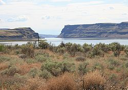
The basalts flows which are visible in the Wallula Gap were laid down during the Miocene Epoch, about 17 million years ago. They are part of the massive fissure flood basalts of the Columbia River Basalt Group
Columbia River Basalt Group
The Columbia River Basalt Group is a large igneous province that lies across parts of the Western United States. It is found in the U.S. states of Washington, Oregon, Idaho, Nevada, and California...
. During the basalt eruptions, the southern & western Columbia Plateau
Columbia Plateau
The Columbia Plateau is a geologic and geographic region that lies across parts of the U.S. states of Washington, Oregon, and Idaho. It is a wide flood basalt plateau between the Cascade Range and the Rocky Mountains, cut through by the Columbia River...
, which included the current location of the Wallula Gap, began to fold. The bending (or shear) of the ancient lava flows is clearly visible in the folded layers of basalt exposed in the steep walls of the gap.
Creation of the Wallula Gap
Blue Mountains (Oregon)
The Blue Mountains are a mountain range in the western United States, located largely in northeastern Oregon and stretching into southeastern Washington...
uplift and was captured by the Salmon-Clearwater River near the Idaho-Oregon border.
Missoula Floods
The Wallula Gap was widened about the 14th millennium BC, by the historic flow of the SalmonSalmon River (Idaho)
The Salmon River is located in Idaho in the northwestern United States. The Salmon is also known as The River of No Return. It flows for through central Idaho, draining and dropping more than between its headwaters, near Galena Summit above the Sawtooth Valley in the Sawtooth National...
, Snake
Snake River
The Snake is a major river of the greater Pacific Northwest in the United States. At long, it is the largest tributary of the Columbia River, the largest North American river that empties into the Pacific Ocean...
, and Columbia rivers combined with the glacial waters that poured across the Channeled Scablands
Channeled scablands
The Channeled Scablands are a unique geological erosion feature in the U.S. state of Washington. They were created by the cataclysmic Missoula Floods that swept periodically across eastern Washington and down the Columbia River Plateau during the Pleistocene epoch. Geologist J Harlen Bretz coined...
during the Missoula Floods
Missoula Floods
The Missoula Floods refer to the cataclysmic floods that swept periodically across eastern Washington and down the Columbia River Gorge at the end of the last ice age. The glacial flood events have been researched since the 1920s...
. The Wallula Gap constrained the flow such that less than 1/5 of the 800 km³ of water per day entering could be discharged as it passed into Lake Condon
Lake Condon
Lake Condon was a temporary lake in the Pacific Northwest region of North America, formed periodically by the Missoula Floods from 15,000 to 13,000 BC....
downstream. As a result, the floods filled the Pasco Basin and formed, for a short period, Lake Lewis
Lake Lewis
Lake Lewis was a temporary lake in the Pacific Northwest region of North America, largely formed by the Missoula Floods in about the 14th millennium B.C....
. The large volumes of flood water passing through the gap contributed substantially to the erosion of the gap, as is evidenced by the shear walls and by scab-features such as "The Sisters".
During the Missoula Floods
Missoula Floods
The Missoula Floods refer to the cataclysmic floods that swept periodically across eastern Washington and down the Columbia River Gorge at the end of the last ice age. The glacial flood events have been researched since the 1920s...
water backed up in the Pasco Basin because of the narrow opening of the Wallula Gap. The floods were so large in volume that they could not rapidly discharge through the gap, even though it is 2 km (1.2 mi) wide. Maximum flood waters reached elevations of about 380 meters. The hydraulic head
Hydraulic head
Hydraulic head or piezometric head is a specific measurement of water pressure above a geodetic datum. It is usually measured as a water surface elevation, expressed in units of length, at the entrance of a piezometer...
required to drive the flood waters through the gap, combined with the elevated levels downstream of the constriction resulted in a head of about 250 meters. The peak flow is estimated to have been about 10 million cubic meters per second.
Lewis & Clark
The Lewis and Clark ExpeditionLewis and Clark Expedition
The Lewis and Clark Expedition, or ″Corps of Discovery Expedition" was the first transcontinental expedition to the Pacific Coast by the United States. Commissioned by President Thomas Jefferson and led by two Virginia-born veterans of Indian wars in the Ohio Valley, Meriwether Lewis and William...
(a.k.a. Corps of Discovery) first saw the Wallula Gap on October 18, 1805, as they headed downstream from their camp on the confluence of the Columbia and Snake rivers. The Corps camped near Spring Gulch Creek that night, and proceeded through Wallula Gap the next day.