

Yakima Training Center
Encyclopedia
United States Army
The United States Army is the main branch of the United States Armed Forces responsible for land-based military operations. It is the largest and oldest established branch of the U.S. military, and is one of seven U.S. uniformed services...
training center (Army maneuver training, land warrior system testing and live fire area) located in south central Washington state. It is bounded on the west by Interstate 82
Interstate 82
Interstate 82 is a Interstate Highway that extends from I-90 in Ellensburg, Washington to I-84 near Umatilla, Oregon in the United States. In the state of Washington, it serves the cities of Ellensburg, Yakima, and the Tri Cities , and in Oregon, it serves Umatilla and Hermiston...
, on the south by the city of Yakima
Yakima, Washington
Yakima is an American city southeast of Mount Rainier National Park and the county seat of Yakima County, Washington, United States, and the eighth largest city by population in the state itself. As of the 2010 census, the city had a total population of 91,196 and a metropolitan population of...
, on the north by the city of Ellensburg
Ellensburg, Washington
Ellensburg is a city in, and the county seat of, Kittitas County, Washington, United States. The population was 18,174 at the 2010 census. The population was 18,250 at 2011 Estimate from Office of Financial Management. Ellensburg is located just east of the Cascade Range on I-90 and is known as the...
and Interstate 90
Interstate 90 in Washington
Interstate 90 , a transcontinental Interstate Highway from Seattle, Washington, to Boston, Massachusetts, crosses the state of Washington before crossing the Idaho state line between Spokane and Post Falls...
, and on the east by the Columbia River
Columbia River
The Columbia River is the largest river in the Pacific Northwest region of North America. The river rises in the Rocky Mountains of British Columbia, Canada, flows northwest and then south into the U.S. state of Washington, then turns west to form most of the border between Washington and the state...
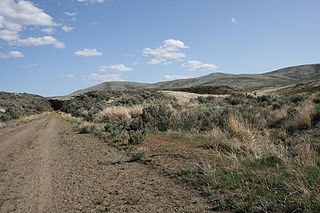
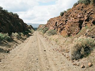
. It comprises 327,000 acres (132,332 hectares) of land, most of which consists of shrub-steppe
Shrub-steppe
Shrub-steppe is a type of low rainfall natural grassland. Shrub-steppes are distinguishable from deserts, which are too dry to support a noticeable cover of perennial grasses or other shrubs, while the shrub-steppe has sufficient moisture levels to support a cover of perennial grasses and/or...
, making it one of the largest areas of shrub-steppe habitat remaining in Washington state. The terrain is undulating and dominated by three east-west parallel ridges, the Saddle Mountains
Saddle Mountains
The Saddle Mountains consists of an upfolded anticline ridge of basalt in Grant County of central Washington state. The ridge, reaching to 2,700 feet, terminates in the east south of Othello, Washington near the foot of the Drumheller Channels...
, Manastash Ridge
Manastash Ridge
Manastash Ridge is a long anticline mountain ridge located in central Washington state in the United States. Manastash Ridge runs mostly west-to-east in Kittitas and Yakima counties, for approximately 50 miles...
, and Umtanum Ridge
Umtanum Ridge
Umtanum Ridge is a long anticline mountain ridge in Yakima County and Kittitas County in the U.S. state of Washington. It runs for approximately 55 miles east-southeast from the Cascade Range, through the Yakima Training Center to the edge of the Columbia River at Priest Rapids Dam and Hanford Reach...
anticline
Anticline
In structural geology, an anticline is a fold that is convex up and has its oldest beds at its core. The term is not to be confused with antiform, which is a purely descriptive term for any fold that is convex up. Therefore if age relationships In structural geology, an anticline is a fold that is...
s, which are part of the Yakima Fold Belt near the western edge of the Columbia River Plateau
Columbia River Plateau
The Columbia Plateau is a geologic and geographic region that lies across parts of the U.S. states of Washington, Oregon, and Idaho. It is a wide flood basalt plateau between the Cascade Range and the Rocky Mountains, cut through by the Columbia River...
. As is common for shrub-steppe, vegetation consists of sagebrush
Sagebrush
Sagebrush is a common name of a number of shrubby plant species in the genus Artemisia native to western North America;Or, the sagebrush steppe ecoregion, having one or more kinds of sagebrush, bunchgrasses and others;...
, bitter brush, and bunch grass.
Fort Lewis
Fort Lewis
Joint Base Lewis-McChord is a United States military facility located south-southwest of Tacoma, Washington. The facility is under the jurisdiction of the United States Army Joint Base Garrison, Joint Base Lewis-McChord....
uses the facility for maneuver and live fire training. Vagabond Army Airfield
Vagabond Army Airfield
Vagabond Army Heliport, formerly Vagabond Army Airfield, is located at the Yakima Training Center in the state of Washington. Currently, only rotary winged aircraft are authorized to land at this facility as the airfield has been closed to fixed wing aircraft. The existing runway currently serves...
and Selah Airstrip
Selah Airstrip
Selah Airstrip is located on the Yakima Training Center with a single runway of about 4600 feet in length and 75 feet in width....
are located on the Yakima Training Center.
History
From 1942-1946 the Army leased 160000 acres (647.5 km²) of land in the area for the Yakima Anti-Aircraft Artillery Range. Then in 1951 the Army purchased 261000 acres (1,056.2 km²) for the Yakima Firing Center, which would become the modern Yakima Training Center.Ancillary functions
In addition to its role as a training facility, the Yakima facility has been asserted to play a major role in ECHELONECHELON
ECHELON is a name used in global media and in popular culture to describe a signals intelligence collection and analysis network operated on behalf of the five signatory states to the UK–USA Security Agreement...
, the global surveillance network operated by the National Security Agency
National Security Agency
The National Security Agency/Central Security Service is a cryptologic intelligence agency of the United States Department of Defense responsible for the collection and analysis of foreign communications and foreign signals intelligence, as well as protecting U.S...
.
Public access
The John Wayne Pioneer TrailJohn Wayne Pioneer Trail
The John Wayne Pioneer Trail follows the former roadbed of the Chicago, Milwaukee, St. Paul and Pacific Railroad for across two-thirds of Washington from the western slopes of the Cascade Mountains to the Idaho border. The Chicago, Milwaukee, St...
crosses the Yakima Training Center on the former roadbed of the Chicago, Milwaukee, St. Paul and Pacific Railroad
Chicago, Milwaukee, St. Paul and Pacific Railroad
The Milwaukee Road, officially the Chicago, Milwaukee, St. Paul and Pacific Railroad , was a Class I railroad that operated in the Midwest and Northwest of the United States from 1847 until its merger into the Soo Line Railroad on January 1, 1986. The company went through several official names...
, which traverses 300 miles (482.8 km) across two-thirds of Washington from the western slopes of the Cascade Mountains to the Idaho
Idaho
Idaho is a state in the Rocky Mountain area of the United States. The state's largest city and capital is Boise. Residents are called "Idahoans". Idaho was admitted to the Union on July 3, 1890, as the 43rd state....
border. The railroad right-of-way was acquired by Washington state and is used as a non-motorized recreational trail. The 20 miles (32.2 km) segment east from Kittitas
Kittitas, Washington
Kittitas is a city in Kittitas County, Washington, United States. The population was 1,381 at the 2010 census.There are numerous interpretations of the name, which is from the language of the Kittitas American Indian language. According to one source, it "has been said to mean everything from...
to the Columbia River
Columbia River
The Columbia River is the largest river in the Pacific Northwest region of North America. The river rises in the Rocky Mountains of British Columbia, Canada, flows northwest and then south into the U.S. state of Washington, then turns west to form most of the border between Washington and the state...
just south of Vantage
Vantage, Washington
Vantage is a census-designated place in Kittitas County, Washington, United States. The population was 70 at the 2000 census.-History:The area around Vantage has been occupied by the Wanapum Native Americans since prehistory. A number of well-preserved rock-paintings have been found on the cliff...
has been developed and is managed as the Iron Horse State Park
Iron Horse State Park
Iron Horse State Park, part of the Washington State Park System, is a state park located in the Cascade Mountains and Yakima River Valley, between Cedar Falls on the west and the Columbia River on the east....
as it crosses the Yakima Training Center. The military also allows hunting when the range is not "hot" (live fire exercises).