

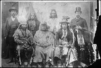
Umatilla (tribe)
Encyclopedia
Sahaptin language
Sahaptin , Sħáptənəxw, is a Plateau Penutian language of the Sahaptian branch spoken in a section of the northwestern plateau along the Columbia River and its tributaries in southern Washington, northern Oregon, and southwestern Idaho....
-speaking Native American group living on the Umatilla Indian Reservation
Umatilla Indian Reservation
The Umatilla Indian Reservation is an Indian reservation in eastern Oregon in the United States, mostly located in Umatilla County, with a very small part extending south into Union County...
, who traditionally inhabited the Columbia Plateau
Columbia Plateau
The Columbia Plateau is a geologic and geographic region that lies across parts of the U.S. states of Washington, Oregon, and Idaho. It is a wide flood basalt plateau between the Cascade Range and the Rocky Mountains, cut through by the Columbia River...
region of the northwestern United States
United States
The United States of America is a federal constitutional republic comprising fifty states and a federal district...
.
The Umatilla share land and a governmental structure with the Cayuse
Cayuse
The Cayuse are a Native American tribe in the state of Oregon in the United States. The Cayuse tribe shares a reservation in northeastern Oregon with the Umatilla and the Walla Walla tribes as part of the Confederated Tribes of the Umatilla Indian Reservation...
and the Walla Walla
Walla Walla (tribe)
Walla Walla |Native American]] tribe of the northwestern United States. The reduplication of the word expresses the diminutive form. The name "Walla Walla" is translated several ways but most often as "many waters."...
tribes as part of the Confederated Tribes of the Umatilla Indian Reservation
Confederated Tribes of the Umatilla Indian Reservation
The Confederated Tribes of the Umatilla Indian Reservation is a federally recognized confederation of three Sahaptin-speaking Native American tribes who traditionally inhabited the Columbia River Plateau region: the Cayuse, Umatilla, and Walla Walla....
. The reservation is located near Pendleton, Oregon
Pendleton, Oregon
Pendleton is a city in Umatilla County, Oregon, United States. Pendleton was named in 1868 by the county commissioners for George H. Pendleton, Democratic candidate for Vice-President in the 1864 presidential campaign. The population was 16,612 at the 2010 census...
near the Blue Mountains
Blue Mountains (Oregon)
The Blue Mountains are a mountain range in the western United States, located largely in northeastern Oregon and stretching into southeastern Washington...
.
A number of places and geographic features have been named after the tribe, such as the Umatilla River
Umatilla River
The Umatilla River is an tributary of the Columbia River in the U.S. state of Oregon. Draining a basin of , it enters the Columbia near the city of Umatilla in the northeastern part of the state...
, Umatilla County
Umatilla County, Oregon
Umatilla County is a county located in the U.S. state of Oregon. It is included in the 8 county definition of Eastern Oregon. The county is named for the Umatilla River. In 2010, its population was 75,889...
, and Umatilla National Forest
Umatilla National Forest
The Umatilla National Forest, in the Blue Mountains of northeast Oregon and southeast Washington, covers an area of 1.4 million acres . In descending order of land area the forest is located in parts of Umatilla, Grant, Columbia, Morrow, Wallowa, Union, Garfield, Asotin, Wheeler, and Walla Walla...
. McNary Dam
McNary Dam
McNary Dam is a 1.4-mile long concrete gravity run-of-the-river dam which spans the Columbia River. It joins Umatilla County, Oregon with Benton County, Washington, 292 miles upriver from the mouth of the Columbia at Astoria, Oregon. It is operated by the U.S. Army Corps of Engineers' McNary...
was almost named Umatilla Dam.
The impoundment of the Columbia River behind the next dam downriver, John Day Dam
John Day Dam
The John Day Dam is a concrete gravity run-of-the-river dam spanning the Columbia River in the northwestern United States. The dam features a navigation lock plus fish ladders on both sides. The John Day Lock has the highest lift of any U.S. lock...
, is called Lake Umatilla.