

Palouse River
Encyclopedia
The Palouse River is a tributary
of the Snake River
located in the U.S. state
s of Washington and Idaho
. It flows for 167 miles (268.8 km) southwestwards, primarily through the Palouse
region of southeastern Washington. It is part of the Columbia River Basin, as the Snake River is a tributary of the Columbia River
.
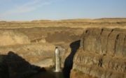
Its canyon was carved out by a fork in the catastrophic Missoula Floods
of the previous ice age
, which spilled over the northern Columbia Plateau
and flowed into the Snake River, eroding the river's present course in a few thousand years.
 The Palouse River flows from northern
Idaho
into southeast Washington through the Palouse
region, named for the river.
The river flows through northern Latah County
near State Highway 6 as it nears the state line. In Washington, the river flows in Whitman County
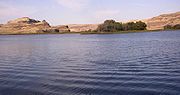
to Palouse
and then to Colfax
, where it meets with the south fork, from Pullman
and south of Moscow
. From Colfax the river meanders west and ends up in the lower Snake River
southwest of Hooper
, but not before dropping over Palouse Falls
. The Palouse River enters the Snake River below the Little Goose Dam
and above the Lower Monumental Dam
.
is 3303 square miles (8,554.7 km²) in area. Its mean annual discharge
, as measured by USGS gage 13351000 at Hooper
(river mile
19.6), is 599 cuft/s, with a maximum daily recorded flow of 27800 cuft/s, and a minimum of zero flow.
that swept periodically across eastern Washington and across the Columbia River Plateau
during the Pleistocene epoch
carved out the Palouse River Canyon, which is 1000 feet (304.8 m) deep in places.
The ancestral Palouse River flowed through the now-dry Washtucna Coulee
directly into the Columbia River
. The present-day canyon was created when the Missoula Floods overtopped the northern drainage divide of the ancestral Palouse River, diverting it to the current course to the Snake River by eroding a new, deeper channel.
The area is characterized by interconnected and hanging flood-created coulees, cataracts, plunge pools, kolk
created potholes, rock benches, buttes and pinnacles typical of scablands.
Tributary
A tributary or affluent is a stream or river that flows into a main stem river or a lake. A tributary does not flow directly into a sea or ocean...
of the Snake River
Snake River
The Snake is a major river of the greater Pacific Northwest in the United States. At long, it is the largest tributary of the Columbia River, the largest North American river that empties into the Pacific Ocean...
located in the U.S. state
U.S. state
A U.S. state is any one of the 50 federated states of the United States of America that share sovereignty with the federal government. Because of this shared sovereignty, an American is a citizen both of the federal entity and of his or her state of domicile. Four states use the official title of...
s of Washington and Idaho
Idaho
Idaho is a state in the Rocky Mountain area of the United States. The state's largest city and capital is Boise. Residents are called "Idahoans". Idaho was admitted to the Union on July 3, 1890, as the 43rd state....
. It flows for 167 miles (268.8 km) southwestwards, primarily through the Palouse
Palouse
The Palouse is a region of the northwestern United States, encompassing parts of southeastern Washington, north central Idaho and, in some definitions, extending south into northeast Oregon. It is a major agricultural area, primarily producing wheat and legumes...
region of southeastern Washington. It is part of the Columbia River Basin, as the Snake River is a tributary of the Columbia River
Columbia River
The Columbia River is the largest river in the Pacific Northwest region of North America. The river rises in the Rocky Mountains of British Columbia, Canada, flows northwest and then south into the U.S. state of Washington, then turns west to form most of the border between Washington and the state...
.
Its canyon was carved out by a fork in the catastrophic Missoula Floods
Missoula Floods
The Missoula Floods refer to the cataclysmic floods that swept periodically across eastern Washington and down the Columbia River Gorge at the end of the last ice age. The glacial flood events have been researched since the 1920s...
of the previous ice age
Ice age
An ice age or, more precisely, glacial age, is a generic geological period of long-term reduction in the temperature of the Earth's surface and atmosphere, resulting in the presence or expansion of continental ice sheets, polar ice sheets and alpine glaciers...
, which spilled over the northern Columbia Plateau
Columbia Plateau
The Columbia Plateau is a geologic and geographic region that lies across parts of the U.S. states of Washington, Oregon, and Idaho. It is a wide flood basalt plateau between the Cascade Range and the Rocky Mountains, cut through by the Columbia River...
and flowed into the Snake River, eroding the river's present course in a few thousand years.
Course
North Central Idaho
North Central Idaho is an area which spans the central part of the state of Idaho and borders Oregon, Montana, and Washington. It is the southern half of the Idaho Panhandle region and is rich in agriculture and natural resources. Lewis and Clark travelled throughout this area on their journey to...
Idaho
Idaho
Idaho is a state in the Rocky Mountain area of the United States. The state's largest city and capital is Boise. Residents are called "Idahoans". Idaho was admitted to the Union on July 3, 1890, as the 43rd state....
into southeast Washington through the Palouse
Palouse
The Palouse is a region of the northwestern United States, encompassing parts of southeastern Washington, north central Idaho and, in some definitions, extending south into northeast Oregon. It is a major agricultural area, primarily producing wheat and legumes...
region, named for the river.
The river flows through northern Latah County
Latah County, Idaho
Latah County is a county located in the north central region of the U.S. state of Idaho. The population was 37,244 at the 2010 census. The county seat and largest city is Moscow, which is the home of the University of Idaho, the state's flagship and land-grant university...
near State Highway 6 as it nears the state line. In Washington, the river flows in Whitman County
Whitman County, Washington
Whitman County is a county located in the U.S. state of Washington. As of the 2010 census, the population was 44,776, with the majority living in its largest city, Pullman, home to Washington State University, the state's land-grant university. The county seat is at Colfax.Whitman County was...
to Palouse
Palouse, Washington
Palouse is a city in Whitman County, Washington, United States. The population was 998 at the 2010 census. Palouse is named for the region of farmland in which it is situated, and was incorporated in 1888.-History:...
and then to Colfax
Colfax, Washington
Colfax is the county seat of Whitman County, Washington, United States.The population was 2,805 at the 2010 census.It is situated amidst wheat-covered hills in a valley at the confluence of the north and south forks of the Palouse River. U.S...
, where it meets with the south fork, from Pullman
Pullman, Washington
Pullman is the largest city in Whitman County, Washington, United States. The population was 24,675 at the 2000 census and 29,799 according to the 2010 census...
and south of Moscow
Moscow, Idaho
Moscow is a city in northern Idaho, situated along the Washington/Idaho border. It is the most populous city and county seat of Latah County and the home of the University of Idaho, the land grant institution and primary research university for the state...
. From Colfax the river meanders west and ends up in the lower Snake River
Snake River
The Snake is a major river of the greater Pacific Northwest in the United States. At long, it is the largest tributary of the Columbia River, the largest North American river that empties into the Pacific Ocean...
southwest of Hooper
Hooper, Washington
Hooper is an unincorporated community in Whitman County, Washington, United States.-History:Hooper was named around 1883 for early settler Albert J. Hooper....
, but not before dropping over Palouse Falls
Palouse Falls
The Palouse Falls lies on the Palouse River, about upstream of the confluence with the Snake River in southeast Washington, United States. The falls are in height...
. The Palouse River enters the Snake River below the Little Goose Dam
Little Goose Lock and Dam
Little Goose Lock and Dam is a hydroelectric, concrete, run-of-the-river dam in Columbia and Whitman counties in the state of Washington, on the Snake River. The dam is located northeast of the town of Starbuck, and north of Dayton....
and above the Lower Monumental Dam
Lower Monumental Lock and Dam
Lower Monumental Lock and Dam is a hydroelectric, concrete, run-of-the-river dam on the Snake River, and bridges Franklin County and Walla Walla County, in the state of Washington. The dam is located six miles south of the town of Kahlotus, and 43 miles north of the town of Walla...
.
Basin and discharge
The Palouse River's drainage basinDrainage basin
A drainage basin is an extent or an area of land where surface water from rain and melting snow or ice converges to a single point, usually the exit of the basin, where the waters join another waterbody, such as a river, lake, reservoir, estuary, wetland, sea, or ocean...
is 3303 square miles (8,554.7 km²) in area. Its mean annual discharge
Discharge (hydrology)
In hydrology, discharge is the volume rate of water flow, including any suspended solids , dissolved chemical species and/or biologic material , which is transported through a given cross-sectional area...
, as measured by USGS gage 13351000 at Hooper
Hooper, Washington
Hooper is an unincorporated community in Whitman County, Washington, United States.-History:Hooper was named around 1883 for early settler Albert J. Hooper....
(river mile
River mile
In the United States, a River mile is a measure of distance in miles along a river from its mouth. River mile numbers begin at zero and increase further upstream. The corresponding metric unit using kilometers is the River kilometer...
19.6), is 599 cuft/s, with a maximum daily recorded flow of 27800 cuft/s, and a minimum of zero flow.
Geology
The Missoula FloodsMissoula Floods
The Missoula Floods refer to the cataclysmic floods that swept periodically across eastern Washington and down the Columbia River Gorge at the end of the last ice age. The glacial flood events have been researched since the 1920s...
that swept periodically across eastern Washington and across the Columbia River Plateau
Columbia River Plateau
The Columbia Plateau is a geologic and geographic region that lies across parts of the U.S. states of Washington, Oregon, and Idaho. It is a wide flood basalt plateau between the Cascade Range and the Rocky Mountains, cut through by the Columbia River...
during the Pleistocene epoch
Pleistocene
The Pleistocene is the epoch from 2,588,000 to 11,700 years BP that spans the world's recent period of repeated glaciations. The name pleistocene is derived from the Greek and ....
carved out the Palouse River Canyon, which is 1000 feet (304.8 m) deep in places.
The ancestral Palouse River flowed through the now-dry Washtucna Coulee
Coulee
Coulee is applied rather loosely to different landforms, all of which refer to a kind of valley or drainage zone.The word coulee comes from the Canadian French coulée, from French word couler meaning "to flow"....
directly into the Columbia River
Columbia River
The Columbia River is the largest river in the Pacific Northwest region of North America. The river rises in the Rocky Mountains of British Columbia, Canada, flows northwest and then south into the U.S. state of Washington, then turns west to form most of the border between Washington and the state...
. The present-day canyon was created when the Missoula Floods overtopped the northern drainage divide of the ancestral Palouse River, diverting it to the current course to the Snake River by eroding a new, deeper channel.
The area is characterized by interconnected and hanging flood-created coulees, cataracts, plunge pools, kolk
Kolk
A kolk is an underwater vortex that is created when rapidly rushing water passes an underwater obstacle in boundary areas of high shear. High velocity gradients produce a violently rotating column of water, similar to a tornado. Kolks are capable of plucking multi-ton blocks of rock and...
created potholes, rock benches, buttes and pinnacles typical of scablands.
See also
- Palouse FallsPalouse FallsThe Palouse Falls lies on the Palouse River, about upstream of the confluence with the Snake River in southeast Washington, United States. The falls are in height...
- Palouse Falls State ParkPalouse Falls State ParkPalouse Falls State Park is a member of the Washington state park system in the Palouse region of Eastern Washington, USA. It is named for the Palouse Falls on the Palouse River, which are part of the park....
- List of rivers of Idaho
- List of rivers of Washington
- Tributaries of the Columbia RiverTributaries of the Columbia RiverTributaries and sub-tributaries are hierarchically listed in order from the mouth of the Columbia River upstream. Major dams and reservoir lakes are also noted.-Minor tributaries:* Skipanon River * Lewis and Clark River * Youngs River...