

Columbia Basin Project
Encyclopedia
The Columbia Basin Project (or CBP) in Central Washington, USA, is the irrigation
network that the Grand Coulee Dam
makes possible. It is the largest water reclamation project in the United States, supplying irrigation water to over 670000 acres (2,711.4 km²) of the 1100000 acres (4,451.5 km²) large project area, all of which was originally intended to be supplied and is still classified as irrigable and open for the possible enlargement of the system. Water pumped from the Columbia River
is carried over 331 miles (532.7 km) of main canals, stored in a number of reservoirs, then fed into 1339 miles (2,154.9 km) of lateral irrigation canals, and out into 3500 miles (5,632.7 km) of drains and wasteways.
was a prime candidate—a desert with fertile loess
soil and the Columbia River
passing through.
Competing groups lobbied for different irrigation projects; a Spokane
group wanted a 134 miles (215.7 km) gravity flow canal from Lake Pend Oreille
while a Wenatchee
group (further south) wanted a large dam on the Columbia River, which would pump water up to fill the nearby Grand Coulee
, a formerly-dry canyon-like coulee
.
After thirteen years of debate, President Franklin D. Roosevelt
authorized the dam project. Construction of Grand Coulee Dam began in 1933 and was completed in 1942. Its main purpose of pumping water for irrigation was postponed during World War II
in favor of electrical power generation that was used for the war effort. Additional hydroelectric generating capacity was added into the 1970s. The Columbia River reservoir behind the dam was named Franklin Delano Roosevelt Lake in honor of the president. The irrigation holding reservoir in Grand Coulee was named Banks Lake
.
After World War II the project suffered a number of setbacks. Irrigation water began to arrive between 1948 and 1952, but the costs escalated, resulting in the original plan, in which the people receiving irrigation water would pay back the costs of the project over time, being repeatedly revised and becoming a permanent water subsidy. In addition, the original vision of a social engineering project intended to help farmers settle on small landholdings failed. Farm plots, at first restricted in size, became larger and soon became corporate agribusiness operations.
The original plan was that a federal agency similar to the Tennessee Valley Authority
would manage the entire system. Both the Bureau of Reclamation and the Department of Agriculture
sought to gain control as the primary administrative agency, and both pressed their own plan for doing so. The rivalry between them was ultimately so paralyzing that a power vacuum was created. Neither agency gain control and large private interests prevailed instead. As a result the original vision lost its cohesive focus and corporate interests gained as the main beneficiaries.
The determination to finish the project's plan to irrigate the full 1100000 acres (4,451.5 km²) waned during the 1960s. The estimated total cost for completing the project had more than doubled between 1940 and 1964, it had become clear that the government's financial investment would not be recovered, and that the benefits of the project were unevenly distributed and increasingly going to larger businesses and corporations. These issues and others dampened enthusiasm for the project, although the exact motives behind the decision to stop construction with the project about half finished are not known.
 The Columbia Basin
in Central Washington is fertile due to its loess soils, but large portions are a near desert
, receiving less than ten inches (254 mm) of rain per year. The area is characterized by huge deposits of flood basalt
, thousands of feet thick in places, laid down over a period of approximately 11 million years, during the Miocene
epoch. These flood basalts are exposed in some places, while in others they are covered with thick layers of loess.
During the last ice age glacier
s shaped the landscape of the Columbia River Plateau
. Ice blocked the Columbia River near the north end of Grand Coulee, creating glacial lakes Columbia
and Spokane. Ice age glaciers also created Glacial Lake Missoula
, in what is now Montana
. Erosion allowed glacial Lake Columbia to begin to drain into what became Grand Coulee, which was fully created when glacial Lake Missoula along with glacial Lake Columbia catastrophically emptied. This flood event was one of several known as the Missoula Floods
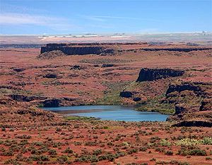
. Unique erosion features, called channeled scablands
, are attributed to these amazing floods.
, is about 30 miles (48.3 km) long. Banks Lake serves as the CBP's initial storage reservoir. Additional canals, siphon
s, and reservoirs were built south of Bank Lake, reaching over 100 miles (160.9 km). Water is lifted 280 feet (85.3 m) from Lake Roosevelt to feed the massive network.
Two and three percent of the Columbia's flow is currently diverted at the Grand Coulee Dam. The amount of water annually diverted into the CBP and used for irrigation is larger than the entire annual flow of the Colorado River
. There are plans to double the area of irrigated land, according to tour guides at the dam, over the next several decades. However, the Bureau of Reclamation website states that no further development is anticipated, with 671000 acres (2,715.4 km²) irrigated out of the original 1100000 acres (4,451.5 km²) planned.
Interest in completing the Columbia Basin Project's 1100000 acres (4,451.5 km²) has grown in the late 20th and early 21st centuries. One reason for the renewed interest is the substantial depletion of the Odessa aquifer. Agricultural operations within the CBP's boundaries but outside the developed portion have for decades used groundwater pumped from the Odessa aquifer to irrigate crops.
was not the primary goal of the project, but during World War II
the demand for electricity in the region boomed. The Hanford nuclear reservation
was built just south of the project and aluminum smelting plants flocked to the Columbia Basin. A new power house was built at the Grand Coulee Dam, starting in the late sixties, that tripled the generating capacity. Part of the dam had to be blown up and re-built to make way for the new generators. Electricity is now transmitted to Canada
and as far south as San Diego.
There are a number of issues regarding the runoff of irrigation water. The project region receives about 6 to 10 inches (254 mm) of annual rainfall, while the application of irrigation water amounts to an equivalent 40 to 50 inches (1,270 mm). The original plans did not sufficiently address the inevitable seepage and runoff. In some cases the results are beneficial. For example, numerous new lakes provide recreation opportunities and habitat for fish and game. In other cases agricultural chemical in the runoff cause pollution.
of the Pacific Northwest who depended on the salmon for a way of life.
The negative environmental impacts of the Columbia Basin Project have made it a contentious and often politicized issue. A common argument for not implementing environmental safeguards at dam sites is that post-construction modifications would likely have to be significant. Tour guides at the Grand Coulee dam site, for example, indicate that a "fish ladder might have to be 5 miles (8 km) long to get the fish up the 550 feet (167.6 m) needed, and many fish would die before reaching the upper end" thus no fish ladders were built. Advocates of remedial measures point out that such steps would still be better than the status quo, which has led to marked die-offs and the likely extinction of several types of salmon.
The massive amounts of irrigation water provided by this project greatly benefits the agricultural production of the area. North Central Washington is one of the largest and most productive tree fruit producing areas on the planet. Without Coulee Dam and the greater Columbia Basin Project, much of North Central Washington State would be too arid for cultivation.
Irrigation
Irrigation may be defined as the science of artificial application of water to the land or soil. It is used to assist in the growing of agricultural crops, maintenance of landscapes, and revegetation of disturbed soils in dry areas and during periods of inadequate rainfall...
network that the Grand Coulee Dam
Grand Coulee Dam
Grand Coulee Dam is a gravity dam on the Columbia River in the U.S. state of Washington built to produce hydroelectric power and provide irrigation. It was constructed between 1933 and 1942, originally with two power plants. A third power station was completed in 1974 to increase its energy...
makes possible. It is the largest water reclamation project in the United States, supplying irrigation water to over 670000 acres (2,711.4 km²) of the 1100000 acres (4,451.5 km²) large project area, all of which was originally intended to be supplied and is still classified as irrigable and open for the possible enlargement of the system. Water pumped from the Columbia River
Columbia River
The Columbia River is the largest river in the Pacific Northwest region of North America. The river rises in the Rocky Mountains of British Columbia, Canada, flows northwest and then south into the U.S. state of Washington, then turns west to form most of the border between Washington and the state...
is carried over 331 miles (532.7 km) of main canals, stored in a number of reservoirs, then fed into 1339 miles (2,154.9 km) of lateral irrigation canals, and out into 3500 miles (5,632.7 km) of drains and wasteways.
History
The U.S. Bureau of Reclamation was created 1902 to aid development of dry western states. Central Washington's Columbia PlateauColumbia Plateau
The Columbia Plateau is a geologic and geographic region that lies across parts of the U.S. states of Washington, Oregon, and Idaho. It is a wide flood basalt plateau between the Cascade Range and the Rocky Mountains, cut through by the Columbia River...
was a prime candidate—a desert with fertile loess
Loess
Loess is an aeolian sediment formed by the accumulation of wind-blown silt, typically in the 20–50 micrometre size range, twenty percent or less clay and the balance equal parts sand and silt that are loosely cemented by calcium carbonate...
soil and the Columbia River
Columbia River
The Columbia River is the largest river in the Pacific Northwest region of North America. The river rises in the Rocky Mountains of British Columbia, Canada, flows northwest and then south into the U.S. state of Washington, then turns west to form most of the border between Washington and the state...
passing through.
Competing groups lobbied for different irrigation projects; a Spokane
Spokane, Washington
Spokane is a city located in the Northwestern United States in the state of Washington. It is the largest city of Spokane County of which it is also the county seat, and the metropolitan center of the Inland Northwest region...
group wanted a 134 miles (215.7 km) gravity flow canal from Lake Pend Oreille
Lake Pend Oreille
Lake Pend Oreille is a lake in the northern Idaho Panhandle, with a surface area of . It is 65 miles long, and 1,150 feet deep in some regions, making it the fifth deepest in the United States. It is fed by the Clark Fork River and the Pack River, and drains via the Pend Oreille River...
while a Wenatchee
Wenatchee, Washington
Wenatchee is located in North Central Washington and is the largest city and county seat of Chelan County, Washington, United States. The population within the city limits in 2010 was 31,925...
group (further south) wanted a large dam on the Columbia River, which would pump water up to fill the nearby Grand Coulee
Grand Coulee
The Grand Coulee is an ancient river bed in the U.S. state of Washington. This National Natural Landmark stretches for about sixty miles southwest from Grand Coulee Dam to Soap Lake, being bisected by Dry Falls into the Upper and Lower Grand Coulee....
, a formerly-dry canyon-like coulee
Coulee
Coulee is applied rather loosely to different landforms, all of which refer to a kind of valley or drainage zone.The word coulee comes from the Canadian French coulée, from French word couler meaning "to flow"....
.
After thirteen years of debate, President Franklin D. Roosevelt
Franklin D. Roosevelt
Franklin Delano Roosevelt , also known by his initials, FDR, was the 32nd President of the United States and a central figure in world events during the mid-20th century, leading the United States during a time of worldwide economic crisis and world war...
authorized the dam project. Construction of Grand Coulee Dam began in 1933 and was completed in 1942. Its main purpose of pumping water for irrigation was postponed during World War II
World War II
World War II, or the Second World War , was a global conflict lasting from 1939 to 1945, involving most of the world's nations—including all of the great powers—eventually forming two opposing military alliances: the Allies and the Axis...
in favor of electrical power generation that was used for the war effort. Additional hydroelectric generating capacity was added into the 1970s. The Columbia River reservoir behind the dam was named Franklin Delano Roosevelt Lake in honor of the president. The irrigation holding reservoir in Grand Coulee was named Banks Lake
Banks Lake
Banks Lake is a long reservoir in central Washington in the United States.Part of the Columbia Basin Project, Banks Lake occupies the northern portion of the Grand Coulee, a formerly dry coulee near the Columbia River, formed by the Missoula Floods during the Pleistocene epoch. Grand Coulee Dam,...
.
After World War II the project suffered a number of setbacks. Irrigation water began to arrive between 1948 and 1952, but the costs escalated, resulting in the original plan, in which the people receiving irrigation water would pay back the costs of the project over time, being repeatedly revised and becoming a permanent water subsidy. In addition, the original vision of a social engineering project intended to help farmers settle on small landholdings failed. Farm plots, at first restricted in size, became larger and soon became corporate agribusiness operations.
The original plan was that a federal agency similar to the Tennessee Valley Authority
Tennessee Valley Authority
The Tennessee Valley Authority is a federally owned corporation in the United States created by congressional charter in May 1933 to provide navigation, flood control, electricity generation, fertilizer manufacturing, and economic development in the Tennessee Valley, a region particularly affected...
would manage the entire system. Both the Bureau of Reclamation and the Department of Agriculture
United States Department of Agriculture
The United States Department of Agriculture is the United States federal executive department responsible for developing and executing U.S. federal government policy on farming, agriculture, and food...
sought to gain control as the primary administrative agency, and both pressed their own plan for doing so. The rivalry between them was ultimately so paralyzing that a power vacuum was created. Neither agency gain control and large private interests prevailed instead. As a result the original vision lost its cohesive focus and corporate interests gained as the main beneficiaries.
The determination to finish the project's plan to irrigate the full 1100000 acres (4,451.5 km²) waned during the 1960s. The estimated total cost for completing the project had more than doubled between 1940 and 1964, it had become clear that the government's financial investment would not be recovered, and that the benefits of the project were unevenly distributed and increasingly going to larger businesses and corporations. These issues and others dampened enthusiasm for the project, although the exact motives behind the decision to stop construction with the project about half finished are not known.
Geology
Columbia Basin
The Columbia Basin, the drainage basin of the Columbia River, occupies a large area–about —of the Pacific Northwest region of North America. In common usage, the term often refers to a smaller area, generally the portion of the drainage basin that lies within eastern Washington.Usage of the term...
in Central Washington is fertile due to its loess soils, but large portions are a near desert
Desert
A desert is a landscape or region that receives an extremely low amount of precipitation, less than enough to support growth of most plants. Most deserts have an average annual precipitation of less than...
, receiving less than ten inches (254 mm) of rain per year. The area is characterized by huge deposits of flood basalt
Flood basalt
A flood basalt or trap basalt is the result of a giant volcanic eruption or series of eruptions that coats large stretches of land or the ocean floor with basalt lava. Flood basalts have occurred on continental scales in prehistory, creating great plateaus and mountain ranges...
, thousands of feet thick in places, laid down over a period of approximately 11 million years, during the Miocene
Miocene
The Miocene is a geological epoch of the Neogene Period and extends from about . The Miocene was named by Sir Charles Lyell. Its name comes from the Greek words and and means "less recent" because it has 18% fewer modern sea invertebrates than the Pliocene. The Miocene follows the Oligocene...
epoch. These flood basalts are exposed in some places, while in others they are covered with thick layers of loess.
During the last ice age glacier
Glacier
A glacier is a large persistent body of ice that forms where the accumulation of snow exceeds its ablation over many years, often centuries. At least 0.1 km² in area and 50 m thick, but often much larger, a glacier slowly deforms and flows due to stresses induced by its weight...
s shaped the landscape of the Columbia River Plateau
Columbia River Plateau
The Columbia Plateau is a geologic and geographic region that lies across parts of the U.S. states of Washington, Oregon, and Idaho. It is a wide flood basalt plateau between the Cascade Range and the Rocky Mountains, cut through by the Columbia River...
. Ice blocked the Columbia River near the north end of Grand Coulee, creating glacial lakes Columbia
Glacial Lake Columbia
Glacial Lake Columbia was the lake formed on the ice-dammed Columbia River behind the Okanogan lobe of the Cordilleran Ice Sheet when the lobe covered of the Waterville Plateau west of Grand Coulee in central Washington state during the Wisconsin glaciation. Lake Columbia was a substantially...
and Spokane. Ice age glaciers also created Glacial Lake Missoula
Glacial Lake Missoula
Glacial Lake Missoula was a prehistoric proglacial lake in western Montana that existed periodically at the end of the last ice age between 15,000 and 13,000 years ago...
, in what is now Montana
Montana
Montana is a state in the Western United States. The western third of Montana contains numerous mountain ranges. Smaller, "island ranges" are found in the central third of the state, for a total of 77 named ranges of the Rocky Mountains. This geographical fact is reflected in the state's name,...
. Erosion allowed glacial Lake Columbia to begin to drain into what became Grand Coulee, which was fully created when glacial Lake Missoula along with glacial Lake Columbia catastrophically emptied. This flood event was one of several known as the Missoula Floods
Missoula Floods
The Missoula Floods refer to the cataclysmic floods that swept periodically across eastern Washington and down the Columbia River Gorge at the end of the last ice age. The glacial flood events have been researched since the 1920s...
. Unique erosion features, called channeled scablands
Channeled scablands
The Channeled Scablands are a unique geological erosion feature in the U.S. state of Washington. They were created by the cataclysmic Missoula Floods that swept periodically across eastern Washington and down the Columbia River Plateau during the Pleistocene epoch. Geologist J Harlen Bretz coined...
, are attributed to these amazing floods.
Irrigation of the Columbia Basin
When it was built, Grand Coulee Dam was the largest dam in the world, but it was only part of the irrigation project. Additional dams were built at the north and south ends of Grand Coulee, the dry canyon south of Grand Coulee Dam, allowing the coulee to be filled with water pumped up from the Columbia River. The resulting reservoir, called Banks LakeBanks Lake
Banks Lake is a long reservoir in central Washington in the United States.Part of the Columbia Basin Project, Banks Lake occupies the northern portion of the Grand Coulee, a formerly dry coulee near the Columbia River, formed by the Missoula Floods during the Pleistocene epoch. Grand Coulee Dam,...
, is about 30 miles (48.3 km) long. Banks Lake serves as the CBP's initial storage reservoir. Additional canals, siphon
Siphon
The word siphon is sometimes used to refer to a wide variety of devices that involve the flow of liquids through tubes. But in the English language today, the word siphon usually refers to a tube in an inverted U shape which causes a liquid to flow uphill, above the surface of the reservoir,...
s, and reservoirs were built south of Bank Lake, reaching over 100 miles (160.9 km). Water is lifted 280 feet (85.3 m) from Lake Roosevelt to feed the massive network.
Two and three percent of the Columbia's flow is currently diverted at the Grand Coulee Dam. The amount of water annually diverted into the CBP and used for irrigation is larger than the entire annual flow of the Colorado River
Colorado River
The Colorado River , is a river in the Southwestern United States and northwestern Mexico, approximately long, draining a part of the arid regions on the western slope of the Rocky Mountains. The watershed of the Colorado River covers in parts of seven U.S. states and two Mexican states...
. There are plans to double the area of irrigated land, according to tour guides at the dam, over the next several decades. However, the Bureau of Reclamation website states that no further development is anticipated, with 671000 acres (2,715.4 km²) irrigated out of the original 1100000 acres (4,451.5 km²) planned.
Interest in completing the Columbia Basin Project's 1100000 acres (4,451.5 km²) has grown in the late 20th and early 21st centuries. One reason for the renewed interest is the substantial depletion of the Odessa aquifer. Agricultural operations within the CBP's boundaries but outside the developed portion have for decades used groundwater pumped from the Odessa aquifer to irrigate crops.
Unintended consequences
HydroelectricityHydroelectricity
Hydroelectricity is the term referring to electricity generated by hydropower; the production of electrical power through the use of the gravitational force of falling or flowing water. It is the most widely used form of renewable energy...
was not the primary goal of the project, but during World War II
World War II
World War II, or the Second World War , was a global conflict lasting from 1939 to 1945, involving most of the world's nations—including all of the great powers—eventually forming two opposing military alliances: the Allies and the Axis...
the demand for electricity in the region boomed. The Hanford nuclear reservation
Hanford Site
The Hanford Site is a mostly decommissioned nuclear production complex on the Columbia River in the U.S. state of Washington, operated by the United States federal government. The site has been known by many names, including Hanford Works, Hanford Engineer Works or HEW, Hanford Nuclear Reservation...
was built just south of the project and aluminum smelting plants flocked to the Columbia Basin. A new power house was built at the Grand Coulee Dam, starting in the late sixties, that tripled the generating capacity. Part of the dam had to be blown up and re-built to make way for the new generators. Electricity is now transmitted to Canada
Canada
Canada is a North American country consisting of ten provinces and three territories. Located in the northern part of the continent, it extends from the Atlantic Ocean in the east to the Pacific Ocean in the west, and northward into the Arctic Ocean...
and as far south as San Diego.
There are a number of issues regarding the runoff of irrigation water. The project region receives about 6 to 10 inches (254 mm) of annual rainfall, while the application of irrigation water amounts to an equivalent 40 to 50 inches (1,270 mm). The original plans did not sufficiently address the inevitable seepage and runoff. In some cases the results are beneficial. For example, numerous new lakes provide recreation opportunities and habitat for fish and game. In other cases agricultural chemical in the runoff cause pollution.
Environmental impact
The most prominent negative environmental impact has been the reduction in native fish stocks above the dams. The majority of fish in the Columbia basin are migratory fish like salmon, sturgeon and steelhead. These migratory fish are often destroyed or unable to pass through the narrow passages and turbines at dams. In addition to the physical barriers the dams pose, the slowing speed and altered course of the river raises temperatures, alters oxygen content, and changes river bed conditions. These altered conditions can stress and potentially kill both migratory and local non-migratory organisms in the river. The decimation of these migratory fish stocks has been especially dire for many of the Native AmericansNative Americans in the United States
Native Americans in the United States are the indigenous peoples in North America within the boundaries of the present-day continental United States, parts of Alaska, and the island state of Hawaii. They are composed of numerous, distinct tribes, states, and ethnic groups, many of which survive as...
of the Pacific Northwest who depended on the salmon for a way of life.
The negative environmental impacts of the Columbia Basin Project have made it a contentious and often politicized issue. A common argument for not implementing environmental safeguards at dam sites is that post-construction modifications would likely have to be significant. Tour guides at the Grand Coulee dam site, for example, indicate that a "fish ladder might have to be 5 miles (8 km) long to get the fish up the 550 feet (167.6 m) needed, and many fish would die before reaching the upper end" thus no fish ladders were built. Advocates of remedial measures point out that such steps would still be better than the status quo, which has led to marked die-offs and the likely extinction of several types of salmon.
The massive amounts of irrigation water provided by this project greatly benefits the agricultural production of the area. North Central Washington is one of the largest and most productive tree fruit producing areas on the planet. Without Coulee Dam and the greater Columbia Basin Project, much of North Central Washington State would be too arid for cultivation.
Economic benefits and costs
According to the federal Bureau of Reclamation the yearly value of the Columbia Basin Project is $630 million in irrigated crops, $950 million in power production, $20 million in flood damage prevention, and $50 million in recreation. The project itself involves costs that are difficult to determine. The farms that receive irrigation water must pay for it, but due to insufficient data from the Bureau of Reclamation it is not possible to compare the total cost paid by the Bureau to the payments received. Nevertheless, the farm payments account for only a small fraction of the total cost to the government, resulting in a the project's agricultural corporations receiving a large water subsidy from the government. Critics describe the CBP as a classical example of federal money being used to subsidize a relatively small group of private special interest irrigation farming in the American West in places where it would never be economically viable under other circumstances.See also
- Tributaries of the Columbia RiverTributaries of the Columbia RiverTributaries and sub-tributaries are hierarchically listed in order from the mouth of the Columbia River upstream. Major dams and reservoir lakes are also noted.-Minor tributaries:* Skipanon River * Lewis and Clark River * Youngs River...
- Cities on the Columbia RiverCities on the Columbia RiverListed in order going downstream:*British Columbia:** Headwaters to the U.S.-Canadian border***Canal Flats***Fairmont Hot Springs***Windermere***Invermere***Radium Hot Springs***Spillimacheen***Golden***Mica Creek***Revelstoke***Nakusp***Castlegar...
- Hydroelectric dams on the Columbia RiverHydroelectric dams on the Columbia RiverHydroelectric dams on the Columbia River and its tributaries in North America.- Mainstem Columbia dams :-Snake River:-Pend Oreille-Clark Fork–Flathead:-Kootenai River:-See also:...
External links
- University of Idaho Libraries Digital Collections- Columbia Basin Project Photographs of the construction of the Columbia Basin Project, with a special emphasis on the construction of Grand Coulee Dam.
- History of the CBP from the Northwest Power and Conservation Council
- Official Website
- http://www.usbr.gov/pn/programs/fcrps/salmonrecovery.htmlOfficial explanation of Salmon Recovery and Salmon Death-minimizing activities required by the Endangered Species ActEndangered Species ActThe Endangered Species Act of 1973 is one of the dozens of United States environmental laws passed in the 1970s. Signed into law by President Richard Nixon on December 28, 1973, it was designed to protect critically imperiled species from extinction as a "consequence of economic growth and...
] - West Coast Salmon Biological Review Team (2003) "Updated Status of Federally Listed ESUs of West Coast Salmon and Steelhead" National Marine Fisheries Service