

List of ecoregions in Oregon
Encyclopedia
U.S. state
A U.S. state is any one of the 50 federated states of the United States of America that share sovereignty with the federal government. Because of this shared sovereignty, an American is a citizen both of the federal entity and of his or her state of domicile. Four states use the official title of...
of Oregon
Oregon
Oregon is a state in the Pacific Northwest region of the United States. It is located on the Pacific coast, with Washington to the north, California to the south, Nevada on the southeast and Idaho to the east. The Columbia and Snake rivers delineate much of Oregon's northern and eastern...
designated by the U.S. Environmental Protection Agency
United States Environmental Protection Agency
The U.S. Environmental Protection Agency is an agency of the federal government of the United States charged with protecting human health and the environment, by writing and enforcing regulations based on laws passed by Congress...
(EPA) and the Commission for Environmental Cooperation
Commission for Environmental Cooperation
The Commission for Environmental Cooperation was established by Canada, Mexico, and the United States to implement the North American Agreement on Environmental Cooperation , the environmental side accord to the North American Free Trade Agreement...
(CEC). The Commission's 1997 report, Ecological Regions of North America, provides a spatial framework that may be used by government agencies, non-governmental organization
Non-governmental organization
A non-governmental organization is a legally constituted organization created by natural or legal persons that operates independently from any government. The term originated from the United Nations , and is normally used to refer to organizations that do not form part of the government and are...
s, and academic researchers as a basis for risk analysis
Risk management
Risk management is the identification, assessment, and prioritization of risks followed by coordinated and economical application of resources to minimize, monitor, and control the probability and/or impact of unfortunate events or to maximize the realization of opportunities...
, resource management
Natural resource management
Natural resource management refers to the management of natural resources such as land, water, soil, plants and animals, with a particular focus on how management affects the quality of life for both present and future generations ....
, and environmental study
Environmental science
Environmental science is an interdisciplinary academic field that integrates physical and biological sciences, to the study of the environment, and the solution of environmental problems...
of the continent's ecosystem
Ecosystem
An ecosystem is a biological environment consisting of all the organisms living in a particular area, as well as all the nonliving , physical components of the environment with which the organisms interact, such as air, soil, water and sunlight....
s. Ecoregions may be identified by similarities in geology
Geology
Geology is the science comprising the study of solid Earth, the rocks of which it is composed, and the processes by which it evolves. Geology gives insight into the history of the Earth, as it provides the primary evidence for plate tectonics, the evolutionary history of life, and past climates...
, physiography, vegetation
Vegetation
Vegetation is a general term for the plant life of a region; it refers to the ground cover provided by plants. It is a general term, without specific reference to particular taxa, life forms, structure, spatial extent, or any other specific botanical or geographic characteristics. It is broader...
, climate
Climate
Climate encompasses the statistics of temperature, humidity, atmospheric pressure, wind, rainfall, atmospheric particle count and other meteorological elemental measurements in a given region over long periods...
, soil
Soil
Soil is a natural body consisting of layers of mineral constituents of variable thicknesses, which differ from the parent materials in their morphological, physical, chemical, and mineralogical characteristics...
s, land use
Land use
Land use is the human use of land. Land use involves the management and modification of natural environment or wilderness into built environment such as fields, pastures, and settlements. It has also been defined as "the arrangements, activities and inputs people undertake in a certain land cover...
, wildlife
Wildlife
Wildlife includes all non-domesticated plants, animals and other organisms. Domesticating wild plant and animal species for human benefit has occurred many times all over the planet, and has a major impact on the environment, both positive and negative....
distributions, and hydrology
Hydrology
Hydrology is the study of the movement, distribution, and quality of water on Earth and other planets, including the hydrologic cycle, water resources and environmental watershed sustainability...
.
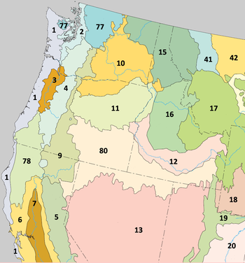
The classification system has four levels. Levels I, III, and IV are shown on this list. Level I divides North America
North America
North America is a continent wholly within the Northern Hemisphere and almost wholly within the Western Hemisphere. It is also considered a northern subcontinent of the Americas...
into 15 ecoregions; of these, 3 are present in Oregon. Level III subdivides the continent into 182 ecoregions; of these, 9 lay partly within Oregon's borders. Level IV is a further subdivision of Level III ecoregions. There are 65 Level IV ecoregions in Oregon, many of which continue into adjacent areas in the neighboring states of Washington, Idaho
Idaho
Idaho is a state in the Rocky Mountain area of the United States. The state's largest city and capital is Boise. Residents are called "Idahoans". Idaho was admitted to the Union on July 3, 1890, as the 43rd state....
, Nevada
Nevada
Nevada is a state in the western, mountain west, and southwestern regions of the United States. With an area of and a population of about 2.7 million, it is the 7th-largest and 35th-most populous state. Over two-thirds of Nevada's people live in the Las Vegas metropolitan area, which contains its...
, and California
California
California is a state located on the West Coast of the United States. It is by far the most populous U.S. state, and the third-largest by land area...
. The task of defining and mapping these ecoregions was carried out by the Oregon Ecoregion Project, a collaborative effort involving the EPA, the United States Geological Survey
United States Geological Survey
The United States Geological Survey is a scientific agency of the United States government. The scientists of the USGS study the landscape of the United States, its natural resources, and the natural hazards that threaten it. The organization has four major science disciplines, concerning biology,...
(USGS), the United States Forest Service (USFS), and other state and federal agencies. The new classification system they developed may differ from previous frameworks developed separately by the agencies.
Oregon is ecologically diverse
Biodiversity
Biodiversity is the degree of variation of life forms within a given ecosystem, biome, or an entire planet. Biodiversity is a measure of the health of ecosystems. Biodiversity is in part a function of climate. In terrestrial habitats, tropical regions are typically rich whereas polar regions...
. The west side
Western Oregon
Western Oregon is a geographical term that is generally taken to mean the part of Oregon within 120 miles of the Oregon Coast, on the west side of the crest of the Cascade Range. The term is applied somewhat loosely however, and is sometimes taken to exclude the southwestern areas of the state,...
of the state has a marine
Marine (ocean)
Marine is an umbrella term. As an adjective it is usually applicable to things relating to the sea or ocean, such as marine biology, marine ecology and marine geology...
-influenced climate and receives plentiful precipitation
Precipitation (meteorology)
In meteorology, precipitation In meteorology, precipitation In meteorology, precipitation (also known as one of the classes of hydrometeors, which are atmospheric water phenomena is any product of the condensation of atmospheric water vapor that falls under gravity. The main forms of precipitation...
three seasons of the year. In contrast, Eastern Oregon
Eastern Oregon
Eastern Oregon is the eastern part of the U.S. state of Oregon. It is not an officially recognized geographic entity, thus the boundaries of the region vary according to context. It is sometimes understood to include only the eight easternmost counties in the state; in other contexts, it includes...
lies in the rain shadow
Rain shadow
A rain shadow is a dry area on the lee side of a mountainous area. The mountains block the passage of rain-producing weather systems, casting a "shadow" of dryness behind them. As shown by the diagram to the right, the warm moist air is "pulled" by the prevailing winds over a mountain...
of the Cascades
Cascade Range
The Cascade Range is a major mountain range of western North America, extending from southern British Columbia through Washington and Oregon to Northern California. It includes both non-volcanic mountains, such as the North Cascades, and the notable volcanoes known as the High Cascades...
and is much drier. The climatic gradient is evident in the state's landscape
Landscape
Landscape comprises the visible features of an area of land, including the physical elements of landforms such as mountains, hills, water bodies such as rivers, lakes, ponds and the sea, living elements of land cover including indigenous vegetation, human elements including different forms of...
s: forest
Forest
A forest, also referred to as a wood or the woods, is an area with a high density of trees. As with cities, depending where you are in the world, what is considered a forest may vary significantly in size and have various classification according to how and what of the forest is composed...
ed mountain
Mountain
Image:Himalaya_annotated.jpg|thumb|right|The Himalayan mountain range with Mount Everestrect 58 14 160 49 Chomo Lonzorect 200 28 335 52 Makalurect 378 24 566 45 Mount Everestrect 188 581 920 656 Tibetan Plateaurect 250 406 340 427 Rong River...
s, glaciated peaks
Glaciated Rocks
Glaciated Rocks are rocks which show evidence of having been exposed to a glacier. Generally they show striations or deep scratches, caused more by the debris being carried by the glacier than by the ice itself...
, shrub
Shrub
A shrub or bush is distinguished from a tree by its multiple stems and shorter height, usually under 5–6 m tall. A large number of plants may become either shrubs or trees, depending on the growing conditions they experience...
- and grass
Grass
Grasses, or more technically graminoids, are monocotyledonous, usually herbaceous plants with narrow leaves growing from the base. They include the "true grasses", of the Poaceae family, as well as the sedges and the rushes . The true grasses include cereals, bamboo and the grasses of lawns ...
-covered plain
Plain
In geography, a plain is land with relatively low relief, that is flat or gently rolling. Prairies and steppes are types of plains, and the archetype for a plain is often thought of as a grassland, but plains in their natural state may also be covered in shrublands, woodland and forest, or...
s, agricultural
Agriculture
Agriculture is the cultivation of animals, plants, fungi and other life forms for food, fiber, and other products used to sustain life. Agriculture was the key implement in the rise of sedentary human civilization, whereby farming of domesticated species created food surpluses that nurtured the...
valley
Valley
In geology, a valley or dale is a depression with predominant extent in one direction. A very deep river valley may be called a canyon or gorge.The terms U-shaped and V-shaped are descriptive terms of geography to characterize the form of valleys...
s, beach
Beach
A beach is a geological landform along the shoreline of an ocean, sea, lake or river. It usually consists of loose particles which are often composed of rock, such as sand, gravel, shingle, pebbles or cobblestones...
es, desert playas, and wetland
Wetland
A wetland is an area of land whose soil is saturated with water either permanently or seasonally. Wetlands are categorised by their characteristic vegetation, which is adapted to these unique soil conditions....
s.
1 Coast RangeCoast Range (ecoregion)The Coast Range ecoregion is a Level III ecoregion designated by the Environmental Protection Agency in the U.S. states of Washington, Oregon, and California...
- 1a Coastal Lowlands
- 1b Coastal Uplands
- 1d Volcanics
- 1f Willapa Hills
- 1g Mid-Coastal Sedimentary
- 1h Southern Oregon Coastal Mountains
- 1i Redwood Zone
3 Willamette ValleyWillamette Valley (ecoregion)The Willamette Valley ecoregion is a Level III ecoregion designated by the United States Environmental Protection Agency in the U.S. states of Oregon and Washington. Slightly larger than the Willamette Valley for which it is named, the ecoregion contains fluvial terraces and floodplains of the...
- 3a Portland/Vancouver Basin
- 3b Willamette River and Tributaries Gallery Forest
- 3c Prairie Terraces
- 3d Valley Foothills
4 CascadesCascades (ecoregion)The Cascades ecoregion is a Level III ecoregion designated by the United States Environmental Protection Agency in the U.S. states of Washington, Oregon, and California...
- 4a Western Cascades Lowlands and Valleys
- 4b Western Cascades Montane Highlands
- 4c Cascade Crest Montane Forest
- 4d Cascade Subalpine/Alpine
- 4e High Southern Cascades Montane Forest
- 4f Southern Cascades
9 Eastern Cascades Slopes and Foothills
- 9b Grand Fir Mixed Forest
- 9c Oak/Conifer Foothills
- 9d Ponderosa Pine/Bitterbrush Woodland
- 9e Pumice Plateau
- 9f Pumice Plateau Basins
- 9g Klamath/Goose Lake Basins
- 9h Fremont Pine/Fir Forest
- 9i Southern Cascades Slope
- 9j Klamath Juniper Woodland
11 Blue MountainsBlue Mountains (ecoregion)The Blue Mountains ecoregion is a Level III ecoregion designated by the United States Environmental Protection Agency in the U.S. state of Oregon, with small areas over the state border in Idaho and southeastern Washington...
- 11a John Day/Clarno Uplands
- 11b John Day/Clarno Highlands
- 11c Maritime-Influenced Zone
- 11d Melange
- 11e Wallowas/Seven Devils Mountains
- 11f Canyons and Dissected Highlands
- 11g Canyons and Dissected Uplands
- 11h Continental Zone Highlands
- 11i Continental Zone Foothills
- 11k Blue Mountain Basins
- 11l Mesic Forest Zone
- 11m Subalpine–Alpine Zone
- 11n Deschutes River Valley
- 11o Cold Basins
78 Klamath MountainsKlamath Mountains (ecoregion)The Klamath Mountains ecoregion is a Level III ecoregion designated by the United States Environmental Protection Agency in the U.S. states of Oregon and California. It lies inland of the Coast Range ecoregion, extending from the Umpqua Valley in the north to the Sacramento Valley in the south...
- 78a Rogue/Illinois Valleys
- 78b Oak Savanna Foothills
- 78c Umpqua Interior Foothills
- 78d Serpentine Siskiyous
- 78e Inland Siskiyous
- 78f Coastal Siskiyous
- 78g Klamath River Ridges
10 Columbia PlateauColumbia Plateau (ecoregion)The Columbia Plateau ecoregion is a Level III ecoregion designated by the United States Environmental Protection Agency in the U.S. states of Oregon and Washington, with small areas over the Washington state border in Idaho...
- 10c Umatilla Plateau
- 10e Pleistocene Lake Basins
- 10g Yakima Folds
- 10i Deep Loess Foothills
- 10k Deschutes/John Day Canyons
- 10n Umatilla Dissected Uplands
12 Snake River PlainSnake River Plain (ecoregion)The Snake River Plain ecoregion is a Level III ecoregion designated by the United States Environmental Protection Agency in the U.S. states of Idaho and Oregon. It follows the Snake River across Idaho, stretching roughly from the Wyoming border to Eastern Oregon in the xeric intermontane west...
- 12a Treasure Valley
- 12j Unwooded Alkaline Foothills
80 Northern Basin and RangeNorthern Basin and Range (ecoregion)The Northern Basin and Range ecoregion is a Level III ecoregion designated by the United States Environmental Protection Agency in the U.S. states of Oregon, Idaho, Nevada, Utah, and California. It contains dissected lava plains, rolling hills, alluvial fans, valleys, and scattered mountain ranges...
- 80a Dissected High Lava Plateau
- 80d Pluvial Lake Basins
- 80e High Desert Wetlands
- 80f Owyhee Uplands and Canyons
- 80g High Lava Plains
- 80j Semiarid Uplands
- 80k Partly Forested Mountains
- 80l Salt Shrub Valleys
- 80m Barren Playas