

Coast Range (ecoregion)
Encyclopedia
United States Environmental Protection Agency
The U.S. Environmental Protection Agency is an agency of the federal government of the United States charged with protecting human health and the environment, by writing and enforcing regulations based on laws passed by Congress...
(EPA) in the U.S. states of Washington, Oregon
Oregon
Oregon is a state in the Pacific Northwest region of the United States. It is located on the Pacific coast, with Washington to the north, California to the south, Nevada on the southeast and Idaho to the east. The Columbia and Snake rivers delineate much of Oregon's northern and eastern...
, and California
California
California is a state located on the West Coast of the United States. It is by far the most populous U.S. state, and the third-largest by land area...
. It stretches along the Pacific Coast
West Coast of the United States
West Coast or Pacific Coast are terms for the westernmost coastal states of the United States. The term most often refers to the states of California, Oregon, and Washington. Although not part of the contiguous United States, Alaska and Hawaii do border the Pacific Ocean but can't be included in...
from the tip of the Olympic Peninsula
Olympic Peninsula
The Olympic Peninsula is the large arm of land in western Washington state of the USA, that lies across Puget Sound from Seattle. It is bounded on the west by the Pacific Ocean, the north by the Strait of Juan de Fuca, and the east by Puget Sound. Cape Alava, the westernmost point in the contiguous...
in the north to the San Francisco Bay
San Francisco Bay
San Francisco Bay is a shallow, productive estuary through which water draining from approximately forty percent of California, flowing in the Sacramento and San Joaquin rivers from the Sierra Nevada mountains, enters the Pacific Ocean...
in the south, including Grays Harbor, Willapa Bay
Willapa Bay
Willapa Bay is a bay located on the southwest Pacific coast of Washington state in the United States. The Long Beach Peninsula separates Willapa Bay from the greater expanse of the Pacific Ocean. With over of water surface Willapa Bay is the second largest estuary on the United States Pacific coast...
, and the Long Beach Peninsula
Long Beach Peninsula
The Long Beach Peninsula is an arm of land in western Washington state. It is bounded on the west by the Pacific Ocean, the south by the Columbia River, and the east by Willapa Bay...
in Washington, the entire length of the Oregon Coast
Oregon Coast
The Oregon Coast is a region of the U.S. state of Oregon. It runs generally north-south along the Pacific Ocean, forming the western border of the state; the region is bounded to the east by the Oregon Coast Range. The Oregon Coast stretches approximately from the Columbia River in the north to...
, and the Northern California Coast
North Coast, California
The North Coast of California is a region which commonly includes Marin, Sonoma, Mendocino, Humboldt, and Del Norte counties...
. Named for the Coast Range mountains
Oregon Coast Range
The Oregon Coast Range, often called simply the Coast Range and sometimes the Pacific Coast Range, is a mountain range, in the Pacific Coast Ranges physiographic region, in the U.S. state of Oregon along the Pacific Ocean...
, it encompasses the lower elevations of the Olympic Mountains
Olympic Mountains
The Olympic Mountains is a mountain range on the Olympic Peninsula of western Washington in the United States. The mountains, part of the Pacific Coast Ranges, are not especially high - Mount Olympus is the highest at - but the western slopes of the Olympics rise directly out of the Pacific...
, the Oregon Coast Range
Oregon Coast Range
The Oregon Coast Range, often called simply the Coast Range and sometimes the Pacific Coast Range, is a mountain range, in the Pacific Coast Ranges physiographic region, in the U.S. state of Oregon along the Pacific Ocean...
, the Californian North Coast Ranges, and surrounding lowland
Lowland
In physical geography, a lowland is any broad expanse of land with a general low level. The term is thus applied to the landward portion of the upward slope from oceanic depths to continental highlands, to a region of depression in the interior of a mountainous region, to a plain of denudation, or...
s.
The low mountain
Mountain
Image:Himalaya_annotated.jpg|thumb|right|The Himalayan mountain range with Mount Everestrect 58 14 160 49 Chomo Lonzorect 200 28 335 52 Makalurect 378 24 566 45 Mount Everestrect 188 581 920 656 Tibetan Plateaurect 250 406 340 427 Rong River...
s of the ecoregion
Ecoregion
An ecoregion , sometimes called a bioregion, is an ecologically and geographically defined area that is smaller than an ecozone and larger than an ecosystem. Ecoregions cover relatively large areas of land or water, and contain characteristic, geographically distinct assemblages of natural...
are covered by highly productive, rain-drenched evergreen forest
Evergreen forest
An temperate evergreen forest is a forest consisting entirely or mainly of evergreen trees that retain green foliage all year round. Such forests exist in the tropics primarily as broadleaf evergreens, and in temperate and boreal latitudes primarily as coniferous evergreens.-Tropical evergreen...
s that are home to the three tallest conifer species in the world: Coast redwood, Coast Douglas-fir
Coast Douglas-fir
Pseudotsuga menziesii, known as Douglas-fir, Oregon Pine, or Douglas spruce, is an evergreen conifer species native to western North America. Its variety Pseudotsuga menziesii var. menziesii, also known as coast Douglas-fir grows in the coastal regions, from west-central British Columbia, Canada...
, and Sitka spruce
Sitka Spruce
Picea sitchensis, the Sitka Spruce, is a large coniferous evergreen tree growing to 50–70 m tall, exceptionally to 95 m tall, and with a trunk diameter of up to 5 m, exceptionally to 6–7 m diameter...
. Historically, Sitka spruce forests dominated the fog-shrouded coast, while a mosaic of western redcedar, western hemlock
Western Hemlock
Tsuga heterophylla. the Western Hemlock, is a species of hemlock native to the west coast of North America, with its northwestern limit on the Kenai Peninsula, Alaska, and its southeastern limit in northern Sonoma County, California.-Habitat:...
, and seral
Seral community
A seral community is an intermediate stage found in ecological succession in an ecosystem advancing towards its climax community. In many cases more than one seral stage evolves until climax conditions are attained...
Douglas-fir
Douglas-fir
Douglas-fir is one of the English common names for evergreen coniferous trees of the genus Pseudotsuga in the family Pinaceae. Other common names include Douglas tree, and Oregon pine. There are five species, two in western North America, one in Mexico, and two in eastern Asia...
blanketed the inland areas. Today, Douglas-fir plantations are prevalent on the intensively logged
Logging
Logging is the cutting, skidding, on-site processing, and loading of trees or logs onto trucks.In forestry, the term logging is sometimes used in a narrow sense concerning the logistics of moving wood from the stump to somewhere outside the forest, usually a sawmill or a lumber yard...
and managed
Natural resource management
Natural resource management refers to the management of natural resources such as land, water, soil, plants and animals, with a particular focus on how management affects the quality of life for both present and future generations ....
landscape. Lithology
Lithology
The lithology of a rock unit is a description of its physical characteristics visible at outcrop, in hand or core samples or with low magnification microscopy, such as colour, texture, grain size, or composition. It may be either a detailed description of these characteristics or be a summary of...
influences land management strategies; slopes underlain by sedimentary rock
Sedimentary rock
Sedimentary rock are types of rock that are formed by the deposition of material at the Earth's surface and within bodies of water. Sedimentation is the collective name for processes that cause mineral and/or organic particles to settle and accumulate or minerals to precipitate from a solution....
are more susceptible to failure following clearcutting
Clearcutting
Clearcutting, or clearfelling, is a controversial forestry/logging practice in which most or all trees in an area are uniformly cut down. Clearcutting, along with shelterwood and seed tree harvests, is used by foresters to create certain types of forest ecosystems and to promote select species that...
and road building than those underlain by volcanic rock
Volcanic rock
Volcanic rock is a rock formed from magma erupted from a volcano. In other words, it is an igneous rock of volcanic origin...
.
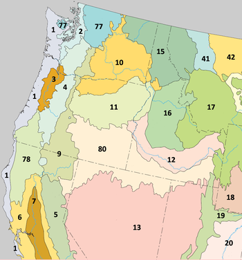
The Coast Range ecoregion has been subdivided into nine Level IV ecoregions. Level IV mapping is not yet complete in California, and the information below includes only the sections in Washington and Oregon.
Level IV ecoregions
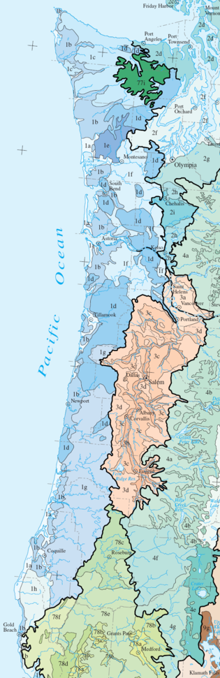
Coastal Lowlands (1a)
The Coastal Lowlands ecoregion contains beachBeach
A beach is a geological landform along the shoreline of an ocean, sea, lake or river. It usually consists of loose particles which are often composed of rock, such as sand, gravel, shingle, pebbles or cobblestones...
es, sand dunes
Dune
In physical geography, a dune is a hill of sand built by wind. Dunes occur in different forms and sizes, formed by interaction with the wind. Most kinds of dunes are longer on the windward side where the sand is pushed up the dune and have a shorter "slip face" in the lee of the wind...
and spits
Spit (landform)
A spit or sandspit is a deposition landform found off coasts. At one end, spits connect to land, and extend into the sea. A spit is a type of bar or beach that develops where a re-entrant occurs, such as at cove's headlands, by the process of longshore drift...
, and low marine terrace
Marine terrace
A marine terrace, coastal terrace, raised beach or perched coastline is a relatively flat, horizontal or gently inclined surface of marine origin, mostly an old abrasion platform which has been lifted out of the sphere of wave activity . Thus it lies above or under the current sea level, depending...
s below 400 feet (122 m) elevation. Characteristic features include wet forests, shallow freshwater
Freshwater
Fresh water is naturally occurring water on the Earth's surface in ice sheets, ice caps, glaciers, bogs, ponds, lakes, rivers and streams, and underground as groundwater in aquifers and underground streams. Fresh water is generally characterized by having low concentrations of dissolved salts and...
lake
Lake
A lake is a body of relatively still fresh or salt water of considerable size, localized in a basin, that is surrounded by land. Lakes are inland and not part of the ocean and therefore are distinct from lagoons, and are larger and deeper than ponds. Lakes can be contrasted with rivers or streams,...
s, estuarine
Estuary
An estuary is a partly enclosed coastal body of water with one or more rivers or streams flowing into it, and with a free connection to the open sea....
marsh
Marsh
In geography, a marsh, or morass, is a type of wetland that is subject to frequent or continuous flood. Typically the water is shallow and features grasses, rushes, reeds, typhas, sedges, other herbaceous plants, and moss....
es, and low-gradient, meandering tannic streams and river
River
A river is a natural watercourse, usually freshwater, flowing towards an ocean, a lake, a sea, or another river. In a few cases, a river simply flows into the ground or dries up completely before reaching another body of water. Small rivers may also be called by several other names, including...
s. Residential, commercial, and recreational developments are expanding in the coastal corridor. Many wetland
Wetland
A wetland is an area of land whose soil is saturated with water either permanently or seasonally. Wetlands are categorised by their characteristic vegetation, which is adapted to these unique soil conditions....
s in the floodplain
Floodplain
A floodplain, or flood plain, is a flat or nearly flat land adjacent a stream or river that stretches from the banks of its channel to the base of the enclosing valley walls and experiences flooding during periods of high discharge...
s of the region's streams have been drained and converted into pasture
Pasture
Pasture is land used for grazing. Pasture lands in the narrow sense are enclosed tracts of farmland, grazed by domesticated livestock, such as horses, cattle, sheep or swine. The vegetation of tended pasture, forage, consists mainly of grasses, with an interspersion of legumes and other forbs...
s for dairy farms, and associated stream degradation has occurred. Mature forests in the region are dominated by a canopy
Canopy (forest)
In biology, the canopy is the aboveground portion of a plant community or crop, formed by plant crowns.For forests, canopy also refers to the upper layer or habitat zone, formed by mature tree crowns and including other biological organisms .Sometimes the term canopy is used to refer to the extent...
of Sitka spruce, western hemlock, and Douglas-fir, with salal
Salal
Gaultheria shallon is a leathery-leaved shrub in the heather family , native to western North America. In English it is known as salal, shallon, or in Britain simply Gaultheria.-Ecology:...
, sword fern, vine maple
Vine Maple
Acer circinatum is a species of maple native to western North America, from southwest British Columbia to northern California, always within 300 km of the Pacific Ocean coast....
, and Oregon grape in the shrub
Shrub
A shrub or bush is distinguished from a tree by its multiple stems and shorter height, usually under 5–6 m tall. A large number of plants may become either shrubs or trees, depending on the growing conditions they experience...
layer. The riparian zone
Riparian zone
A riparian zone or riparian area is the interface between land and a river or stream. Riparian is also the proper nomenclature for one of the fifteen terrestrial biomes of the earth. Plant habitats and communities along the river margins and banks are called riparian vegetation, characterized by...
supports red alder
Red Alder
Alnus rubra, the Red alder, is a deciduous broadleaf tree native to western North America.-Description:It is the largest species of alder in North America and one of the largest in the world, reaching heights of 20–35 m. The official tallest red alder stands 32 meters tall in Clatsop County, Oregon...
, western redcedar, and bigleaf maple
Bigleaf Maple
Acer macrophyllum is a large deciduous tree in the genus Acer.It can grow to be up to 35 m tall, but more commonly grows 15 m to 20 m tall. It is native to western North America, mostly near the Pacific coast, from southernmost Alaska to southern California...
with an understory
Understory
Understory is the term for the area of a forest which grows at the lowest height level below the forest canopy. Plants in the understory consist of a mixture of seedlings and saplings of canopy trees together with understory shrubs and herbs...
of salmonberry
Salmonberry
Rubus spectabilis is a species of Rubus native to the west coast of North America from west central Alaska to California....
; California bay-laurel is common in the south. Estuaries and coastal wetlands may feature Baltic rush, Lyngby’s sedge, tufted hairgrass, Pacific silverleaf, and seaside arrowgrass with shore pine, sweet gale, and Hooker’s willow. Stabilized dunes support shore pine over salal, rhododendron
Rhododendron
Rhododendron is a genus of over 1 000 species of woody plants in the heath family, most with showy flowers...
, and evergreen blueberry, with dune wildrye, Chilean strawberry, and dune bentgrass. Soil texture
Soil texture
Soil texture is a qualitative classification tool used in both the field and laboratory to determine classes for agricultural soils based on their physical texture. The classes are distinguished in the field by the 'textural feel' which can be further clarified by separating the relative...
s range from silt
Silt
Silt is granular material of a size somewhere between sand and clay whose mineral origin is quartz and feldspar. Silt may occur as a soil or as suspended sediment in a surface water body...
y clay
Clay
Clay is a general term including many combinations of one or more clay minerals with traces of metal oxides and organic matter. Geologic clay deposits are mostly composed of phyllosilicate minerals containing variable amounts of water trapped in the mineral structure.- Formation :Clay minerals...
loam
Loam
Loam is soil composed of sand, silt, and clay in relatively even concentration . Loam soils generally contain more nutrients and humus than sandy soils, have better infiltration and drainage than silty soils, and are easier to till than clay soils...
to sand
Sand
Sand is a naturally occurring granular material composed of finely divided rock and mineral particles.The composition of sand is highly variable, depending on the local rock sources and conditions, but the most common constituent of sand in inland continental settings and non-tropical coastal...
y loam. The region covers 633 square miles (1,639 km²) in Oregon and 353 square miles (914 km²) in Washington, with the largest contiguous areas found near Grays Harbor, Willapa Bay, the mouth of the Columbia River
Columbia River
The Columbia River is the largest river in the Pacific Northwest region of North America. The river rises in the Rocky Mountains of British Columbia, Canada, flows northwest and then south into the U.S. state of Washington, then turns west to form most of the border between Washington and the state...
, Tillamook Bay
Tillamook Bay
Tillamook Bay is a small inlet of the Pacific Ocean, approximately 6 mi long and 2 mi wide, on the northwest coast of the U.S. state of Oregon...
, and along the southern Oregon Coast. Public lands include the Grays Harbor
Grays Harbor National Wildlife Refuge
Grays Harbor National Wildlife Refuge is located within Grays Harbor Estuary, at the mouth of the Chehalis River, which makes up the second largest watershed in Washington. It is one of four major staging areas for migrating shorebirds in the Pacific Flyway...
, Willapa
Willapa National Wildlife Refuge
Willapa National Wildlife Refuge is a National Wildlife Refuge located on the shores of Willapa Bay in Washington, USA. It comprises of sand dunes, sand beaches, mud flats, grasslands, saltwater and freshwater marshes, and coniferous forest...
, Nestucca Bay
Nestucca Bay National Wildlife Refuge
Nestucca Bay National Wildlife Refuge is a U.S. National Wildlife Refuge on Oregon's coast. It is located in southern Tillamook County, on the state's northern coast. It is one of six National Wildlife Refuges comprising the Oregon Coast National Wildlife Refuge Complex and supports one tenth of...
, Siletz Bay
Siletz Bay National Wildlife Refuge
Siletz Bay National Wildlife Refuge is a U.S. National Wildlife Refuge on Oregon's coast. It is one of six National Wildlife Refuges comprising the Oregon Coast National Wildlife Refuge Complex. The refuge consists of several discontinuous tracts north and south of the Siletz River where it enters...
, and Bandon Marsh
Bandon Marsh National Wildlife Refuge
Bandon Marsh National Wildlife Refuge is a U.S. National Wildlife Refuge on Oregon's coast. It is one of six National Wildlife Refuges comprising the Oregon Coast National Wildlife Refuge Complex and is renowned among bird watchers for being able to view rare shorebirds including Ruff, Hudsonian...
National Wildlife Refuges, the Oregon Dunes National Recreation Area
Oregon Dunes National Recreation Area
The Oregon Dunes National Recreation Area is located on the Oregon Coast, stretching approximately 40 miles north from the Coos River in North Bend, to the Siuslaw River, in Florence. The NRA is part of Siuslaw National Forest and is administered by the United States Forest Service...
, and numerous state parks.
Coastal Uplands (1b)
The Coastal Uplands ecoregion includes the headlandsHeadlands and bays
Headlands and bays are two related features of the coastal environment.- Geology and geography :Headlands and bays are often found on the same coastline. A bay is surrounded by land on three sides, whereas a headland is surrounded by water on three sides. Headlands are characterized by high,...
, high marine terraces, hill
Hill
A hill is a landform that extends above the surrounding terrain. Hills often have a distinct summit, although in areas with scarp/dip topography a hill may refer to a particular section of flat terrain without a massive summit A hill is a landform that extends above the surrounding terrain. Hills...
s, and low mountains surrounding the Coastal Lowlands, with medium to high gradient tannic streams. Elevation varies from 400 to 2500 feet (120 to 760 m). The climate is marine-influenced
Oceanic climate
An oceanic climate, also called marine west coast climate, maritime climate, Cascadian climate and British climate for Köppen climate classification Cfb and subtropical highland for Köppen Cfb or Cwb, is a type of climate typically found along the west coasts at the middle latitudes of some of the...
with an extended winter rainy season
Wet season
The the wet season, or rainy season, is the time of year, covering one or more months, when most of the average annual rainfall in a region occurs. The term green season is also sometimes used as a euphemism by tourist authorities. Areas with wet seasons are dispersed across portions of the...
and minimal seasonal temperature extremes. Abundant fog during the summer dry season
Dry season
The dry season is a term commonly used when describing the weather in the tropics. The weather in the tropics is dominated by the tropical rain belt, which oscillates from the northern to the southern tropics over the course of the year...
reduces vegetation moisture stress
Moisture stress
Moisture stress occurs when the water in a plant's cells is reduced to less than normal levels. This can occur because of a lack of water in the plant's root zone, higher rates of transpiration than the rate of moisture uptake by the roots, for example, because of an inability to absorb water due...
. The Uplands region roughly corresponds with the historic distribution of Sitka spruce. After extensive logging, most of the Sitka spruce is gone, and today the forests are dominated by Douglas-fir and western hemlock, with a shrub layer of salal, sword fern, vine maple, Oregon grape, rhododendron, and evergreen blueberry. Wetter slopes and riparian areas feature red alder, bigleaf maple, and western redcedar, with a salmonberry and currant
Ribes
Ribes is a genus of about 150 species of flowering plants native throughout the temperate regions of the Northern Hemisphere. It is usually treated as the only genus in the family Grossulariaceae. Seven subgenera are recognized....
understory. The headlands are covered by grassland
Grassland
Grasslands are areas where the vegetation is dominated by grasses and other herbaceous plants . However, sedge and rush families can also be found. Grasslands occur naturally on all continents except Antarctica...
s. The region is nearly three times the size of the Coastal Lowlands, covering 1431 square miles (3,706 km²) in Washington and 1117 square miles (2,893 km²) in Oregon. Public lands include the Drift Creek Wilderness
Drift Creek Wilderness
Drift Creek Wilderness is a wilderness area in the Siuslaw National Forest on the Oregon Coast. It was created in 1984, along with two other small wilderness areas in the Forest - Cummins Creek Wilderness and Rock Creek Wilderness. The elevation of Drift Creek ranges from , and is characterized...
, the Siuslaw National Forest
Siuslaw National Forest
Siuslaw National Forest is a national forest in western Oregon, United States. Established in 1908, the Siuslaw is made up of a wide variety of ecosystems, ranging from coastal forests to sand dunes.- Geography :...
, and the Lewis and Clark
Lewis and Clark National Wildlife Refuge
Lewis and Clark National Wildlife Refuge, near the mouth of the Columbia River, provides wintering and resting areas for an estimated 1,000 tundra swans, 5,000 geese, and 30,000 ducks. Other species include shorebirds and bald eagles....
and Cape Meares
Cape Meares National Wildlife Refuge
Cape Meares National Wildlife Refuge is a National Wildlife Refuge on the Oregon coast. It is one of six National Wildlife Refuges in the Oregon Coast National Wildlife Refuge Complex. Located on Cape Meares, the refuge was established in 1938 to protect a remnant of coastal old-growth forest and...
national wildlife refuges. California has not been mapped yet.
Low Olympics (1c)
The Low Olympics ecoregion contains foothills and lower mountains of the Olympic Range, with U-shaped valleyValley
In geology, a valley or dale is a depression with predominant extent in one direction. A very deep river valley may be called a canyon or gorge.The terms U-shaped and V-shaped are descriptive terms of geography to characterize the form of valleys...
s and high gradient streams. It rises to an elevation of approximately 4000 feet (1,219 m). Higher areas were glaciated
Glacier
A glacier is a large persistent body of ice that forms where the accumulation of snow exceeds its ablation over many years, often centuries. At least 0.1 km² in area and 50 m thick, but often much larger, a glacier slowly deforms and flows due to stresses induced by its weight...
. Copious precipitation (up to 200 inches (5,080 mm) a year) supports a lush, epiphyte
Epiphyte
An epiphyte is a plant that grows upon another plant non-parasitically or sometimes upon some other object , derives its moisture and nutrients from the air and rain and sometimes from debris accumulating around it, and is found in the temperate zone and in the...
-rich rainforest of western hemlock, western red cedar, and Douglas-fir, with Pacific silver fir
Pacific Silver Fir
Abies amabilis, commonly known as the Pacific silver fir, is a fir native to the Pacific Northwest of North America, occurring in the Pacific Coast Ranges and the Cascade Range from the extreme southeast of Alaska, through western British Columbia, Washington and Oregon, to the extreme northwest of...
at higher elevations. Riparian zones support red alder and bigleaf maple forests. Much of the region is in the third rotation of logging, including land within the Olympic National Forest
Olympic National Forest
Olympic National Forest is a U.S. National Forest located in Washington, USA. With an area of 633,677 acres , it nearly surrounds Olympic National Park and the Olympic Mountain range. Olympic National Forest contains parts of Clallam, Grays Harbor, Jefferson, and Mason counties...
. However, a portion of the region lies within Olympic National Park
Olympic National Park
Olympic National Park is located in the U.S. state of Washington, in the Olympic Peninsula. The park can be divided into four basic regions: the Pacific coastline, alpine areas, the west side temperate rainforest and the forests of the drier east side. U.S...
and contains ancient forests
Old growth forest
An old-growth forest is a forest that has attained great age , and thereby exhibits unique ecological features. An old growth forest has also usually reached a climax community...
with extremely high biomass
Biomass
Biomass, as a renewable energy source, is biological material from living, or recently living organisms. As an energy source, biomass can either be used directly, or converted into other energy products such as biofuel....
. The region covers 1685 square miles (4,364 km²), entirely on the Olympic Peninsula of Washington. The higher elevations of the Olympic Mountains to the east are designated as part of the North Cascades ecoregion.
Volcanics (1d)
The Volcanics ecoregion consists of steeply sloping mountains and capes underlain by fractured basaltic rocksBasalt
Basalt is a common extrusive volcanic rock. It is usually grey to black and fine-grained due to rapid cooling of lava at the surface of a planet. It may be porphyritic containing larger crystals in a fine matrix, or vesicular, or frothy scoria. Unweathered basalt is black or grey...
. Elevation generally varies from 600 to 4100 feet (180 to 1250 m), although in some places the volcanic rock extends down to sea level
Sea level
Mean sea level is a measure of the average height of the ocean's surface ; used as a standard in reckoning land elevation...
. The region is marked by columnar and pillow basalt outcrop
Outcrop
An outcrop is a visible exposure of bedrock or ancient superficial deposits on the surface of the Earth. -Features:Outcrops do not cover the majority of the Earth's land surface because in most places the bedrock or superficial deposits are covered by a mantle of soil and vegetation and cannot be...
s. Its mountains may have been offshore seamount
Seamount
A seamount is a mountain rising from the ocean seafloor that does not reach to the water's surface , and thus is not an island. These are typically formed from extinct volcanoes, that rise abruptly and are usually found rising from a seafloor of depth. They are defined by oceanographers as...
s engulfed by continental sediment
Sediment
Sediment is naturally occurring material that is broken down by processes of weathering and erosion, and is subsequently transported by the action of fluids such as wind, water, or ice, and/or by the force of gravity acting on the particle itself....
s about 200 million years ago
Triassic
The Triassic is a geologic period and system that extends from about 250 to 200 Mya . As the first period of the Mesozoic Era, the Triassic follows the Permian and is followed by the Jurassic. Both the start and end of the Triassic are marked by major extinction events...
. High gradient, cascading streams and rivers occur, and the basaltic substrate
Stratum
In geology and related fields, a stratum is a layer of sedimentary rock or soil with internally consistent characteristics that distinguish it from other layers...
preserves summer flows that are more consistent than streams on the sedimentary rocks in surrounding ecoregions. The streams still support runs
Salmon run
The salmon run is the time at which salmon swim back up the rivers in which they were born to spawn. All Pacific salmon die after spawning. While most Atlantic salmon die after their first spawn, about 5-10% return to the sea to feed between spawnings. The annual run is a major event for sport...
of spring chinook salmon
Chinook salmon
The Chinook salmon, Oncorhynchus tshawytscha, is the largest species in the pacific salmon family. Other commonly used names for the species include King salmon, Quinnat salmon, Spring salmon and Tyee salmon...
and summer steelhead
Rainbow trout
The rainbow trout is a species of salmonid native to tributaries of the Pacific Ocean in Asia and North America. The steelhead is a sea run rainbow trout usually returning to freshwater to spawn after 2 to 3 years at sea. In other words, rainbow trout and steelhead trout are the same species....
. The region's Douglas-fir plantations are heavily logged. Mature forests consist of Douglas-fir, western hemlock, salal, sword fern, vine maple, Oregon grape, and rhododendron. Wetter slopes and riparian areas may support western redcedar, bigleaf maple, red alder, salmonberry, and oxalis
Oxalis
Oxalis is by far the largest genus in the wood-sorrel family Oxalidaceae: of the approximately 900 known species in the Oxalidaceae, 800 belong here...
. Grassy coastal headlands and mountaintop balds feature Roemer’s fescue, thin bentgrass, California oatgrass, and diverse forb
Forb
A forb is a herbaceous flowering plant that is not a graminoid . The term is used in biology and in vegetation ecology, especially in relation to grasslands and understory.-Etymology:...
s. This large but disjunct ecoregion covers 2043 square miles (5,291 km²) in Oregon and 1542 square miles (3,994 km²) in Washington, including parts of the Olympic and Siuslaw National Forests and the Cummins Creek
Cummins Creek Wilderness
The Cummins Creek Wilderness is a wilderness area in the Siuslaw National Forest on the Oregon coast. It is one of three wilderness areas created in the Siuslaw in 1984, along with Drift Creek and Rock Creek...
and Rock Creek
Rock Creek Wilderness
The Rock Creek Wilderness is a wilderness area comprising within the Siuslaw National Forest on the Oregon Coast. It was created in 1984, along with the Drift Creek Wilderness and Cummins Creek Wilderness.-Topography:...
Wildernesses, as well as higher elevations in the Cape Meares National Wildlife Refuge. California has not been mapped yet.
Outwash (1e)
The Outwash ecoregion is a gently sloping fan of glacial outwashSandur
A sandur is a glacial outwash plain formed of sediments deposited by meltwater at the terminus of a glacier.- Formation :Sandar are found in glaciated areas, such as Svalbard, Kerguelen Islands, and Iceland...
material that forms a series of undulating terraces and plateau
Plateau
In geology and earth science, a plateau , also called a high plain or tableland, is an area of highland, usually consisting of relatively flat terrain. A highly eroded plateau is called a dissected plateau...
s. Elevation varies from 20 to 1000 feet (6 to 300 m). The region lies outside the zone of marine influence, and its medium gradient streams and rivers have lower summer flow than most other parts of the Coast Range. Mature forest types include Douglas-fir, western hemlock, red alder, bigleaf maple, and western red cedar, but today the region is largely dominated by industrial timber plantations. It is the smallest of the Coast Range subregions, covering 354 square miles (917 km²) in Grays Harbor County north of Aberdeen, Washington
Aberdeen, Washington
Aberdeen is a city in Grays Harbor County, Washington, United States, founded by Samuel Benn in 1884. Aberdeen was incorporated on May 12, 1890. The city is the economic center of Grays Harbor County, bordering the cities of Hoquiam and Cosmopolis...
.
Willapa Hills (1f)
The Willapa Hills ecoregion (named for the Willapa HillsWillapa Hills
The Willapa Hills is a geologic, physiographic, and geographic region in southwest Washington. When described as a physiographical province, the Willapa Hills are bounded by the Pacific Ocean to the west, the Columbia River to the south, the Olympic Mountains to the north, and the Cascade Range to...
) consists of low, rolling hills and low, gently sloping mountains with medium gradient streams and rivers. It rises to an elevation of approximately 1300 feet (396 m). This region has a lower drainage density
Drainage density
Drainage density is the total length of all the streams and rivers in a drainage basin divided by the total area of the drainage basin. It is a measure of how well or how poorly a watershed is drained by stream channels...
than other upland areas in the Coast Range. Logging is relatively easy and less expensive in this accessible terrain, and industrial timberland has almost completely replaced the historic forests. When disturbed, the silt- and clay-textured soils are easily eroded
Erosion
Erosion is when materials are removed from the surface and changed into something else. It only works by hydraulic actions and transport of solids in the natural environment, and leads to the deposition of these materials elsewhere...
, thereby degrading stream quality. The vegetation consists of Douglas-fir and western hemlock forests, with sword fern, vine maple, salal, Oregon grape, and rhododendron shrub layer. Wetter slopes and riparian areas support red alder, western redcedar, bigleaf maple, salmonberry, and oxalis. Large herds of Roosevelt elk
Roosevelt elk
The Roosevelt elk , also known as Olympic elk, is the largest of the four surviving subspecies of elk in North America...
winter in the region. The region covers 1277 square miles (3,307 km²) in southwestern Washington and 751 square miles (1,945 km²) in northwestern Oregon, inland from the coast.
Mid-Coastal Sedimentary (1g)
The mountainous Mid-Coastal Sedimentary ecoregion lies outside of the coastal fog zone and is typically underlain by massive bedsBed (geology)
In geology a bed is the smallest division of a geologic formation or stratigraphic rock series marked by well-defined divisional planes separating it from layers above and below. A bed is the smallest lithostratigraphic unit, usually ranging in thickness from a centimeter to several meters and...
of sandstone
Sandstone
Sandstone is a sedimentary rock composed mainly of sand-sized minerals or rock grains.Most sandstone is composed of quartz and/or feldspar because these are the most common minerals in the Earth's crust. Like sand, sandstone may be any colour, but the most common colours are tan, brown, yellow,...
and siltstone
Siltstone
Siltstone is a sedimentary rock which has a grain size in the silt range, finer than sandstone and coarser than claystones.- Description :As its name implies, it is primarily composed of silt sized particles, defined as grains 1/16 - 1/256 mm or 4 to 8 on the Krumbein phi scale...
. Elevation varies from 300 to 3000 feet (90 to 900 m). The region is more rugged than the geologically similar Willapa Hills. Its Douglas-fir forests are intensively managed for logging, and the slopes are prone to failure when disturbed, particularly south of the Siuslaw River
Siuslaw River
The Siuslaw River is a river, approximately 110 mi long, along the Pacific coast of Oregon in the United States. It drains an area of approximately in the Central Oregon Coast Range southwest of the Willamette Valley and north of the watershed of the Umpqua River.It rises in the mountains...
. Stream sedimentation is higher than in the Volcanics ecoregion. The mature forest consists of Douglas-fir and western hemlock, with salal, sword fern, vine maple, Oregon grape, and rhododendron; tanoak
Tanoak
Tanoak, formerly known taxonomically as Lithocarpus densiflorus, was recently moved into a new genus, Notholithocarpus, based on multiple lines of evidence....
may be found on drier slopes to the south. Wetter slopes and riparian areas support bigleaf maple, western redcedar, grand fir
Grand Fir
Abies grandis is a fir native to the Pacific Northwest and Northern California of North America, occurring at altitudes of sea level to 1,800 m...
, red alder, salmonberry, and oxalis, with California bay-laurel in the south. This is the largest of the Coast Range subregions, covering 3739 square miles (9,684 km²) in the Central
Central Oregon Coast Range
The Central Oregon Coast Range is the middle section of the Oregon Coast Range, in the Pacific Coast Ranges physiographic region, and located in the west-central portion of the state of Oregon, United States roughly between the Salmon River and the Umpqua River and the Willamette Valley and the...
and Southern Oregon Coast Range
Southern Oregon Coast Range
The Southern Oregon Coast Range is the southernmost section of the Oregon Coast Range, in the Pacific Coast Ranges, located in the southwest portion of the state of Oregon, United States roughly between the Umpqua River and the middle fork of the Coquille River, beyond which are the Klamath...
.
Southern Oregon Coastal Mountains (1h)
The Southern Oregon Coastal Mountains ecoregion is a geologically and botanically diverseBiodiversity
Biodiversity is the degree of variation of life forms within a given ecosystem, biome, or an entire planet. Biodiversity is a measure of the health of ecosystems. Biodiversity is in part a function of climate. In terrestrial habitats, tropical regions are typically rich whereas polar regions...
ecoregion that is a transition zone between the Coast Range and the Siskiyou Mountains
Siskiyou Mountains
The Siskiyou Mountains are a coastal mountain range in the northern Klamath Mountains in northwestern California and southwestern Oregon in the United States. They extend in an arc for approximately from east of Crescent City, California northeast along the north side of the Klamath River into...
, which form part of the Klamath Mountains ecoregion
Klamath Mountains (ecoregion)
The Klamath Mountains ecoregion is a Level III ecoregion designated by the United States Environmental Protection Agency in the U.S. states of Oregon and California. It lies inland of the Coast Range ecoregion, extending from the Umpqua Valley in the north to the Sacramento Valley in the south...
to the east. Rising to an elevation of approximately 4000 feet (1,219 m), this region has the climate of the Coast Range but the varied lithology of the higher, more dissected Siskiyou Mountains, underlain by Jurassic
Jurassic
The Jurassic is a geologic period and system that extends from about Mya to Mya, that is, from the end of the Triassic to the beginning of the Cretaceous. The Jurassic constitutes the middle period of the Mesozoic era, also known as the age of reptiles. The start of the period is marked by...
sandstone, metamorphosed sediments
Metamorphic rock
Metamorphic rock is the transformation of an existing rock type, the protolith, in a process called metamorphism, which means "change in form". The protolith is subjected to heat and pressure causing profound physical and/or chemical change...
, granite
Granite
Granite is a common and widely occurring type of intrusive, felsic, igneous rock. Granite usually has a medium- to coarse-grained texture. Occasionally some individual crystals are larger than the groundmass, in which case the texture is known as porphyritic. A granitic rock with a porphyritic...
, and serpentinite
Serpentinite
Serpentinite is a rock composed of one or more serpentine group minerals. Minerals in this group are formed by serpentinization, a hydration and metamorphic transformation of ultramafic rock from the Earth's mantle...
. Distributions of northern and southern vegetation blend together here and species diversity
Species diversity
Species diversity is an index that incorporates the number of species in an area and also their relative abundance. It is a more comprehensive value than species richness....
is high. Douglas-fir, western hemlock, tanoak, Port Orford cedar, and western redcedar are present, along with salal, sword fern, vine maple, Oregon grape, rhododendron, California bay-laurel, bigleaf maple, grand fir, red alder, salmonberry, and oxalis. The region covers 692 square miles (1,792 km²) in a remote area of Curry County
Curry County, Oregon
Curry County is a county located in the U.S. state of Oregon. In 2010, its population was 22,364. The county is named for George Law Curry, a governor of the Oregon Territory. The seat of the county is Gold Beach.-Economy:...
in southwestern Oregon containing the Sixes
Sixes River
The Sixes River is a river, approximately 30 mi long, in southwestern Oregon in the United States. It drains a rugged region of the Coastal Range along the Pacific coast south of Coos Bay....
and Elk River
Elk River (Oregon)
The Elk River is in southwestern Oregon in the United States. Approximately 25 miles long, the river drains a remote area of the Coastal Range into the Pacific Ocean....
drainages. It includes Grassy Knob Wilderness
Grassy Knob Wilderness
Grassy Knob Wilderness is a wilderness area in the Klamath Mountains of southwestern Oregon, within the Rogue River-Siskiyou National Forest. It was designated wilderness by the United States Congress in 1984 and now comprises a total of...
within the Siskiyou National Forest.
Redwood Zone (1i)
The low mountains of the Redwood Zone ecoregion lie entirely within the coastal fog zone. Elevation varies from 50 to 1800 feet (15 to 550 m). Historically, unbroken redwood forests moderated the local climate by trapping the coastal fog and producing shade. Remnants of unlogged redwood forest still survive east of Brookings, OregonBrookings, Oregon
Brookings is a city in Curry County, Oregon, United States. It was named after John E. Brookings, president of the Brookings Lumber and Box Company, which founded the city in 1908. As of the 2010 census the population was 6,336. The total population of the Brookings area is over 13,000, which...
. Today, the region is characteristically covered by a mixed forest of coast redwood and Douglas-fir, with a shrub layer of vine maple, rhododendron, sword fern, and oxalis. The region covers 31 square miles (80 km²) in the far southwestern corner of Oregon. Larger sections in northwestern California have not been mapped yet.
See also
- Ecoregions defined by the EPA and the Commission for Environmental CooperationCommission for Environmental CooperationThe Commission for Environmental Cooperation was established by Canada, Mexico, and the United States to implement the North American Agreement on Environmental Cooperation , the environmental side accord to the North American Free Trade Agreement...
:- List of ecoregions in North America (CEC)
- List of ecoregions in the United States (EPA)
- List of ecoregions in Oregon
- List of ecoregions in Washington
- List of ecoregions in California
- The conservation group World Wildlife Fund maintains an alternate classification system:
- List of ecoregions (WWF)
- List of ecoregions in the United States (WWF)