

Olympic Peninsula
Encyclopedia

Western Washington
Western Washington is a region of the United States defined as that part of Washington west of the Cascade Mountains.It is known as being far wetter in climate than the eastern portion of the state, which...
state of the USA, that lies across Puget Sound
Puget Sound
Puget Sound is a sound in the U.S. state of Washington. It is a complex estuarine system of interconnected marine waterways and basins, with one major and one minor connection to the Strait of Juan de Fuca and the Pacific Ocean — Admiralty Inlet being the major connection and...
from Seattle
Seattle, Washington
Seattle is the county seat of King County, Washington. With 608,660 residents as of the 2010 Census, Seattle is the largest city in the Northwestern United States. The Seattle metropolitan area of about 3.4 million inhabitants is the 15th largest metropolitan area in the country...
. It is bounded on the west by the Pacific Ocean
Pacific Ocean
The Pacific Ocean is the largest of the Earth's oceanic divisions. It extends from the Arctic in the north to the Southern Ocean in the south, bounded by Asia and Australia in the west, and the Americas in the east.At 165.2 million square kilometres in area, this largest division of the World...
, the north by the Strait of Juan de Fuca
Strait of Juan de Fuca
The Strait of Juan de Fuca is a large body of water about long that is the Salish Sea outlet to the Pacific Ocean...
, and the east by Puget Sound
Puget Sound
Puget Sound is a sound in the U.S. state of Washington. It is a complex estuarine system of interconnected marine waterways and basins, with one major and one minor connection to the Strait of Juan de Fuca and the Pacific Ocean — Admiralty Inlet being the major connection and...
. Cape Alava
Cape Alava
Cape Alava, in Clallam County, Washington, U.S.A., is the westernmost point in the contiguous 48 states, with a longitude of . The westernmost point is located in Olympic National Park and the Ozette Indian Reservation...
, the westernmost point in the contiguous United States
United States
The United States of America is a federal constitutional republic comprising fifty states and a federal district...
, and Cape Flattery, the north-westernmost point, are on the peninsula. The Olympic Peninsula contained many of the last unexplored places in the lower 48. It remained largely unmapped until Arthur Dodwell and Theodore Rixon mapped most of its topography and timber resources between 1898 and 1900.
Geography
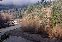
The Olympic Peninsula is home to temperate rain forestTemperate rain forest
Temperate rainforests are coniferous or broadleaf forests that occur in the temperate zone and receive high rainfall.-Definition:For temperate rain forests of North America, Alaback's definition is widely recognized:-Global distribution:...
s, including the Hoh, Queets, and Quinault. Rain forest vegetation is concentrated primarily in the western part of the peninsula, as the interior mountains create a rain shadow
Rain shadow
A rain shadow is a dry area on the lee side of a mountainous area. The mountains block the passage of rain-producing weather systems, casting a "shadow" of dryness behind them. As shown by the diagram to the right, the warm moist air is "pulled" by the prevailing winds over a mountain...
effect in areas to the east, resulting in a much drier climate in those locales.
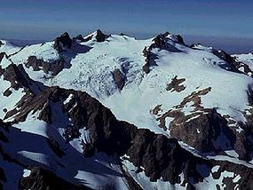
The Olympic mountain range
Olympic Mountains
The Olympic Mountains is a mountain range on the Olympic Peninsula of western Washington in the United States. The mountains, part of the Pacific Coast Ranges, are not especially high - Mount Olympus is the highest at - but the western slopes of the Olympics rise directly out of the Pacific...
sits in the center of the Olympic Peninsula. This range is the second largest in Washington State. Its highest peak is Mt. Olympus
Mount Olympus (Washington)
Mount Olympus is the tallest and most prominent mountain in the Olympic Mountains of western Washington state. Located on the Olympic Peninsula, it is the central feature of Olympic National Park. Mount Olympus is the highest summit of the Olympic Mountains, however, peaks such as Mount Constance,...
.
Major salmon-bearing rivers on the Olympic Peninsula include, clockwise from the southwest: the Humptulips
Humptulips River
The Humptulips River is a river in Grays Harbor County, Washington, in the United States. Its main tributaries are the East Fork Humptulips River, about long , and West Fork Humptulips River, about long . After the forks join, the main river is approximately 20 miles long.The Humptulips has a...
, the Quinault
Quinault River
The Quinault River is a long river located on the Olympic Peninsula in the U.S. state of Washington. It originates deep in the Olympic Mountains in the Olympic National Park. It flows southwest through the "Enchanted Valley". Several miles above Lake Quinault the river is joined by its main...
, the Queets
Queets River
The Queets River is a river in the U.S. state of Washington. It is located on the Olympic Peninsula, mostly within the Olympic National Park and empties into the Pacific Ocean.The Queets River is long. Its drainage basin is in area...
, the Quillayute
Quillayute River
The Quillayute River is a river situated on the Olympic Peninsula in Washington. It empties to the Pacific Ocean at La Push, Washington. The Quillayute River is formed by the confluence of the Bogachiel River and the Sol Duc River...
, Bogachiel
Bogachiel River
The Bogachiel River is a river of the Olympic Peninsula in the U.S. state of Washington. It originates near Bogachiel Peak, flows west through the mountains of Olympic National Park...
, the Sol Duc
Sol Duc River
The Sol Duc River is a river in the U.S. state of Washington. About long, it flows west through the northwest part of the Olympic Peninsula, from the Olympic Mountains of Olympic National Park and Olympic National Forest, then through the broad Sol Duc Valley...
, the Lyre
Lyre River
The Lyre River is a river in Washington, USA that flows out of Lake Crescent in the Olympic National Park and into the Strait of Juan de Fuca. Originally referred to as "singing waters" by the Indians living near it, the river was first named Rio de Cuesta by Europeans in 1790 by Gonzalo López de...
, the Elwha
Elwha River
The Elwha River is a -long river located on the Olympic Peninsula in the U.S. state of Washington. From its source at Elwha snowfinger in the Olympic Range of Olympic National Park it flows generally north to the Strait of Juan de Fuca. Most of the river is contained within Olympic National Park...
(see Elwha Ecosystem Restoration
Elwha Ecosystem Restoration
The Elwha Ecosystem Restoration Project in the United States is the largest dam removal project in history and the second largest ecosystem restoration project in the history of the National Park Service, after the Restoration of the Everglades...
), the Dungeness
Dungeness River
The Dungeness River is a long river located in the Olympic Peninsula in the U.S. state of Washington. It rises near Mount Constance in the Olympic Mountains within the Olympic National Park, flows through the Buckhorn Wilderness, passes by the town of Sequim, and empties into the Strait of Juan de...
, the Dosewallips
Dosewallips River
The Dosewallips River is a river situated on the Olympic Peninsula in the U.S. state of Washington. It rises near Mount Anderson in the Olympic Mountains within Olympic National Park and drains to Hood Canal and thence to the Pacific Ocean....
, the Hamma Hamma
Hamma Hamma River
The Hamma Hamma River is a river on the Olympic Peninsula in the U.S. state of Washington. It rises near Mount Washington in the Olympic Mountains within the Olympic National Park and drains to Hood Canal and thence to the Pacific Ocean....
, the Skokomish
Skokomish River
The Skokomish River is a river in Mason County, Washington, United States. It is the largest river flowing into Hood Canal, an arm of Puget Sound. From its source at the confluence of the North and South Forks the main stem Skokomish River is approximately long. The longer South Fork Skokomish...
, and the Wynoochee River
Wynoochee River
The Wynoochee River is a long river located in the Olympic Peninsula in the U.S. state of Washington. A tributary of the Chehalis River, the Wynoochee River rises in the Olympic Mountains within the Olympic National Park and flows generally south. Its drainage basin is in area...
.
Natural lakes on the peninsula include Kitsap Lake, Lake Crescent
Lake Crescent
Lake Crescent is a deep lake located entirely within Olympic National Park in Clallam County, Washington, United States, approximately west of Port Angeles, Washington on U.S. Route 101 and nearby to the small community of Piedmont...
, Lake Ozette
Lake Ozette
Ozette Lake is the largest unaltered natural lake in Washington state at 29.5 km² .The Makah name for Lake Ozette was Kahouk meaning "large lake." Eight miles long and three miles wide, Ozette Lake is contained within the northern boundary of the Olympic National Park's coastal strip...
, Lake Sutherland
Lake Sutherland
Lake Sutherland is located on the Olympic Peninsula about west of Port Angeles, Washington. The lake is located just to the east of Lake Crescent. Lake Sutherland drains into Indian Creek, which is a tributary of the Elwha River....
, Lake Quinault
Lake Quinault
Lake Quinault is a lake on the Olympic Peninsula in western Washington state, USA. It is located in the glacial-carved Quinault Valley of the Quinault River, at the southern edge of Olympic National Park in the northwestern United States...
, and Lake Pleasant
Lake Pleasant (Washington)
Lake Pleasant is a lake located in Clallam County, Washington, United States. The lake is one of the few that is surrounded by private property and is open to fishing all year around. Types of fish at Lake Pleasant are rainbow trout, kokanee, catfish. Salmon spawn in the lake each year. Water...
. Four dammed rivers form the reservoirs of Lake Aldwell
Lake Aldwell
Lake Aldwell is a reservoir located about from the mouth of the Elwha River on the Olympic Peninsula in the state of Washington. The reservoir was created in 1913 behind the Elwha Dam...
, Lake Mills
Lake Mills (Washington)
Lake Mills is a reservoir formed by the Glines Canyon Dam on the Elwha River located about 13 miles from the mouth of the river on the Olympic Peninsula. It is fully contained within Olympic National Park. The lake was created behind the Glines Canyon Dam. It was formed in 1927 with the completion...
, Lake Cushman
Lake Cushman
Lake Cushman is a lake and reservoir on the north fork of the Skokomish River in Mason County, Washington. The lake originally was a long narrow broadening of the Skokomish River formed in a glacial trough and dammed by a terminal moraine from the last ice age, during the Vashon stade.The lake was...
, and Wynoochee Lake.
The peninsula contains many state and national parks, including Anderson Lake
Anderson Lake State Park
Anderson Lake State Park on the Quimper Peninsula in Jefferson County, Washington is one of the Washington State Parks. It consists of of woods and wetland sloping down to the lake. Available activities include hiking, mountain biking, boating, fishing, and birdwatching.-References:...
, Bogachiel
Bogachiel State Park
Bogachiel State Park in Clallam County, Washington, United States is a State Park. It is located approximately six miles south of the city of Forks on Highway 101. Bogachiel was established in 1931 and the state began staffing it in 1961....
, Dosewallips
Dosewallips State Park
Dosewallips State Park in Jefferson County, Washington is one of the Washington State Parks. It consists of with of saltwater shoreline on Hood Canal and of freshwater shoreline on each side of the Dosewallips River...
, Fort Flagler
Fort Flagler State Park
Fort Flagler State Park is a Washington state park on the site of Fort Flagler, a former United States Army fort at the northern end of Marrowstone Island. From Fort Flagler, visitors can see Port Townsend to the northwest, the cranes at the Navy base on Indian Island to the west, and Whidbey...
, Fort Worden, Kitsap Memorial
Kitsap Memorial State Park
Kitsap Memorial State Park in Kitsap County, Washington is one of the Washington State Parks. It consists of with campsites, group facilities, and of saltwater shoreline on Hood Canal. Available activities include hiking, scuba diving, fishing, swimming, clamming, crabbing, beachcombing,...
, Lake Cushman, Manchester
Manchester State Park
Manchester State Park may refer to:*Manchester State Park *Manchester State Park...
, Mystery Bay
Mystery Bay State Park
Mystery Bay State Park is a Washington state park on Mystery Bay, a small inlet off of Scow Bay/Kilisut Harbor on the western side of Marrowstone Island...
, Old Fort Townsend, Potlatch
Potlatch State Park
Potlatch State Park is a state park in the state of Washington in the United States. It is located on Hood Canal near the town of Potlatch.-External links:*, Washington State Parks...
, Sequim Bay
Sequim Bay State Park
Sequim Bay State Park in Clallam County, Washington is a marine camping park in the Washington State Park System. It consists of with of saltwater shoreline in the Sequim rain shadow on the Olympic Peninsula just within Puget Sound...
, Shine Tidelands
Shine Tidelands State Park
Shine Tidelands State Park in Jefferson County, Washington is one of the Washington State Parks. It consists of of tidelands with of saltwater shoreline on Bywater Bay south of Port Ludlow. At high tide, there is very little beach above water. Available activities include fishing, clamming,...
, and Triton Cove
Triton Cove State Park
Triton Cove State Park at the southeasternmost corner of Jefferson County, Washington is one of the Washington State Parks. It consists of with of saltwater shoreline on Hood Canal. Available activities include boating , scuba diving, fishing, crabbing, and birdwatching.-References:...
state parks; Olympic National Park
Olympic National Park
Olympic National Park is located in the U.S. state of Washington, in the Olympic Peninsula. The park can be divided into four basic regions: the Pacific coastline, alpine areas, the west side temperate rainforest and the forests of the drier east side. U.S...
; and the Olympic National Forest
Olympic National Forest
Olympic National Forest is a U.S. National Forest located in Washington, USA. With an area of 633,677 acres , it nearly surrounds Olympic National Park and the Olympic Mountain range. Olympic National Forest contains parts of Clallam, Grays Harbor, Jefferson, and Mason counties...
. Within the Olympic National Forest, there are five designated wilderness areas: The Brothers
The Brothers Wilderness
The Brothers Wilderness area is located in the Olympic National Forest on the eastern side of the Olympic Peninsula south of Buckhorn Wilderness and north of Mt. Skokomish Wilderness. The area was created in 1984 and now includes . The Brothers wilderness is named after The Brothers peaks which...
, Buckhorn
Buckhorn Wilderness
The Buckhorn Wilderness is a mountainous wilderness area on the northeastern Olympic Peninsula in Washington, USA. Named after Buckhorn Mountain , the wilderness abuts the eastern boundary of Olympic National Park which includes nearby Mount Constance , Inner Constance , Warrior Peak , and Mount...
, Colonel Bob
Colonel Bob Wilderness
Colonel Bob Wilderness is a 48 km2 protected area located in the southwest corner of Olympic National Forest in Washington State. It is named after 19th century orator Robert Green Ingersoll. Lake Quinault lies about 15 miles to the west. Elevations in the wilderness vary from 300 to 4,509...
, Mt. Skokomish, and Wonder Mountain
Wonder Mountain Wilderness
Wonder Mountain Wilderness is a designated wilderness area encompassing Wonder Mountain in the Olympic National Forest on the Olympic Peninsula of Washington in the United States. The wilderness was established in 1984 and comprises . It borders Olympic National Park and is administered by the US...
. Just off the west coast is the Washington Islands Wilderness
Washington Islands Wilderness
Washington Islands Wilderness is a protected area consisting of more than 600 islands, rocks, and reefs belonging to the three Washington Islands National Wildlife Refuges in Washington state...
.
A major effort is underway to protect additional wilderness areas on the Olympic National Peninsula, protect salmon streams under the Wild & Scenic River Act and provide a means for Olympic National Park to offer to buy land adjacent to the Park from willing sellers. Wild Olympics Campaign
Clallam, Kitsap
Kitsap County, Washington
Kitsap County is a county located in the U.S. state of Washington, named after Chief Kitsap of the Suquamish tribe. As of 2011 state estimate, its population was 253,900. Its county seat is at Port Orchard, and its largest city is Bremerton....
and Jefferson
Jefferson County, Washington
Jefferson County is a county located in the U.S. state of Washington, named after Thomas Jefferson. As of 2010, the population was 29,872. The county seat is at Port Townsend, which is also the county's only incorporated city....
counties, as well as the northern parts of Grays Harbor
Grays Harbor County, Washington
Grays Harbor County is a county in the state of Washington, in the United States of America. As of 2010, the population was 72,797. The county seat is at Montesano, and its largest city is Aberdeen. The county is named after a large estuarine bay near its southwestern corner...
and Mason counties, are on the peninsula. The Kitsap Peninsula
Kitsap Peninsula
The Kitsap Peninsula is an arm of land that is part of the larger Olympic Peninsula in Washington state that lies west of Seattle across Puget Sound. Hood Canal separates Kitsap Peninsula from the rest of the Olympic Peninsula...
, bounded by the Hood Canal and the Puget Sound, is an arm of land extending from the larger Olympic Peninsula.
From Olympia
Olympia, Washington
Olympia is the capital city of the U.S. state of Washington and the county seat of Thurston County. It was incorporated on January 28, 1859. The population was 46,478 at the 2010 census...
, the state capital, U.S. Route 101
U.S. Route 101 in Washington
In the U.S. state of Washington, U.S. Route 101 is the westernmost state highway, serving the Olympic Peninsula. It runs from the Astoria-Megler Bridge north to the cities of Raymond, Aberdeen, Hoquiam, and Forks before turning east at the small community of Beaver to the most northern point of the...
runs along the Olympic Peninsula's
southern edge and up the western and northern shorelines. Port Angeles, the Peninsula's second largest town, was once designated as The United States Auxiliary Capitol.
Politics
It is represented in the U.S. House of RepresentativesUnited States House of Representatives
The United States House of Representatives is one of the two Houses of the United States Congress, the bicameral legislature which also includes the Senate.The composition and powers of the House are established in Article One of the Constitution...
by Norman D. Dicks
Norman D. Dicks
Norman DeValois "Norm" Dicks is the U.S. Representative for , serving since 1977. He is a member of the Democratic Party...
.
Cities and towns
- Amanda ParkAmanda Park, WashingtonAmanda Park is an unincorporated community located in the Olympic Peninsula in Grays Harbor County, Washington, United States, along U.S. Route 101. Olympic National Park and Lake Quinault are directly to the north....
- BelfairBelfair, WashingtonBelfair is an unincorporated community in Mason County, Washington, United States. Located on the Union River, headwaters of the Hood Canal, a branch of Puget Sound, it serves as the commercial center of North Mason County. The population of the surrounding area swells in the summertime as...
- BremertonBremerton, WashingtonBremerton is a city in Kitsap County, Washington, United States. The population was 38,790 at the 2011 State Estimate, making it the largest city on the Olympic Peninsula. Bremerton is home to Puget Sound Naval Shipyard and the Bremerton Annex of Naval Base Kitsap...
- BrinnonBrinnon, Washington-Demographics:As of the census of 2000, there were 803 people, 413 households, and 258 families residing in the CDP. The population density was 81.3 people per square mile . There were 912 housing units at an average density of 92.4/sq mi...
- ChimacumChimacum, WashingtonChimacum is an unincorporated community in eastern Jefferson County, Washington, United States. It lies on the Olympic Peninsula. It was named after the Chimakum group of Native Americans that lived there until the late 19th century.Chimacum is the home of Chimacum Schools' main campus, which...
- Clallam BayClallam Bay, WashingtonClallam Bay is an unincorporated community in Clallam County, Washington, United States, at the confluence of the Clallam River and Clallam Bay. Known for its natural beauty and hunting, Clallam Bay is partially reliant on tourism. Clallam Bay is considered the twin city of nearby...
- Discovery BayDiscovery Bay, WashingtonDiscovery Bay is:* A small bay adjoining the Strait of Juan de Fuca on the Olympic Peninsula in Washington State; this body of water was also historically called Port Discovery...
- EldonEldon, WashingtonEldon is an unincorporated community in Mason County, Washington, United States. Eldon is located along U.S. Route 101 on the scenic Hood Canal...
- ForksForks, Washington-Government:The City is organized under Washington State law as a Non-charter Code City. Its structure is that of an elected Mayor and a five member elected City Council...
- HoodsportHoodsport, WashingtonHoodsport is an unincorporated community in Mason County, Washington, United States. Hoodsport is located along the Hood Canal, at the intersection of U.S. Route 101 and State Route 119. Lake Cushman is nearby. Hoodsport is the gateway to the Staircase area of Olympic National Park.The first...
- HoquiamHoquiam, WashingtonHoquiam is a city in Grays Harbor County, Washington state, United States. The town borders the city of Aberdeen at Myrtle Street with Hoquiam to the west. The two cities share a common economic history in lumbering and exporting but Hoquiam has maintained its independent identity...
- HumptulipsHumptulips, WashingtonHumptulips is a census-designated place in Grays Harbor County, Washington, United States. The population was 255 at the 2010 census.-Geography:Humptulips is located at ....
- KalalochKalaloch, WashingtonKalaloch is an unincorporated community in western Jefferson County, Washington, United States. The community is a resort on the bluffs just off of Highway 101 on the Olympic Peninsula in Washington overlooking the Pacific Ocean. A number of log cabins provide accommodations, as does the Kalaloch...
- La PushLa Push, WashingtonLa Push is a small unincorporated community in Clallam County, Washington, United States. It is home to the Quileute tribe and is located along the Quileute River. La Push is known for its whale-watching and natural beauty.- Geography :...
- LilliwaupLilliwaup, WashingtonLilliwaup is a small unincorporated community in Mason County, Washington, United States. It is located on the west shore of Hood Canal at the mouth of Lilliwaup Creek. US Highway 101 passes through the town.-History:...
- MoclipsMoclips, WashingtonMoclips is a census-designated place in Grays Harbor County, Washington, United States. The population was 207 at the 2010 census. It is located near the mouth of the Moclips River....
- Neah BayNeah Bay, WashingtonNeah Bay is a census-designated place on the Makah Indian reservation in Clallam County, Washington, United States. The population was 794 at the 2000 census.-Geography:Neah Bay is located at ....
- Ocean CityOcean City, WashingtonOcean City is a census-designated place in Grays Harbor County, Washington, United States. The population was 217 at the 2000 census.-Geography:Ocean City is located at ....
- Ocean ShoresOcean Shores, Washington-Demographics:As of the census of 2000, there were 3,836 people, 1,789 households, and 1,198 families residing in the city. The population density was 444.7 people per square mile . There were 3,170 housing units at an average density of 367.5 per square mile...
- OzetteOzette, WashingtonOzette is an unincorporated community in Clallam County, Washington, United States. At 124 degrees, 40 minutes, 1 second West longitude, it is the westernmost populated area in the contiguous United States. The 22 mile long Hoko-Ozette Road, accessed via Washington State Route 112, terminates at...
- Pacific BeachPacific Beach, WashingtonPacific Beach is an unincorporated community in Grays Harbor County, Washington, United States, by the Pacific Ocean. There are many hotels there and a stretch of usable beach area is available to those who visit.-History:...
- Port AngelesPort Angeles, WashingtonPort Angeles is a city in and the county seat of Clallam County, Washington, United States. The population was 19,038 at the 2010 census. The area's harbor was dubbed Puerto de Nuestra Señora de los Ángeles by Spanish explorer Francisco de Eliza in 1791, but by the mid-19th century the name had...
- Port Hadlock
- Port LudlowPort Ludlow, WashingtonPort Ludlow is a census-designated place in Jefferson County, Washington, United States. It is also the name of the marine inlet on which the CDP is located. The CDP's population was 1,968 at the 2000 census. Originally a logging and sawmill community, its economy declined during the first half of...
- Port OrchardPort Orchard, WashingtonPort Orchard is a city in and the county seat of Kitsap County, Washington, United States. It is located 13 miles due west of West Seattle and connected to Seattle and Vashon Island via the Washington State Ferries run to Southworth...
- Port TownsendPort Townsend, WashingtonPort Townsend is a city in Jefferson County, Washington, United States, approximately north-northwest of Seattle . The population was 9,113 at the 2010 census an increase of 9.3% over the 2000 census. It is the county seat and only incorporated city of Jefferson County...
- PotlatchPotlatch, WashingtonPotlatch is an unincorporated community in Mason County, Washington, United States. It is located on the western shore of The Great Bend of Hood Canal, near the mouth of the Skokomish River....
- PoulsboPoulsbo, WashingtonPoulsbo is a city on Liberty Bay in Kitsap County, Washington, United States. It is the fourth largest city in Kitsap County and one of the main suburbs of Seattle in the Kitsap area. The population was 9,200 at the 2010 census....
- QuilceneQuilcene, WashingtonQuilcene is a census-designated place in Jefferson County, Washington, United States. The population was 591 at the 2000 census.The community is located on the scenic Olympic Peninsula along the seawater-filled glacial valley of the Hood Canal...
- QuinaultQuinault, WashingtonQuinault is an unincorported community in Washington in Grays Harbor County, Washington, United States. Quinault is located on the Olympic Peninsula....
- SequimSequim, WashingtonSequim is a city in Clallam County, Washington, United States. The 2010 US Census counted a population of 6,606. Sequim is located along the Dungeness River near the base of the Olympic Mountains...
- SekiuSekiu, WashingtonSekiu is an unincorporated community in Clallam County, Washington, United States. Overlooking the west side of Clallam Bay and the Strait of Juan de Fuca, it is twinned with Clallam Bay, on the east side of the bay....
- SheltonShelton, WashingtonShelton is the county seat, of Mason County, Washington, United States. Shelton is the westernmost city on Puget Sound. The population was 9,834 at the 2010 census. In terms of population, the city is ranked 161 out of approximately 500 municipalities in Washington...
- UnionUnion, WashingtonUnion is a small unincorporated community in Mason County, Washington, United States. The town lies along the southern shore of Hood Canal, at an area known as "the Great Bend". There is no U.S. Census data for the location...
External links
- Olympic National Park
- University of Washington Libraries Digital Collections – The Pacific Northwest Olympic Peninsula Community Museum A web-based museum showcasing aspects of the rich history and culture of Washington State's Olympic Peninsula communities. Features cultural exhibits, curriculum packets and a searchable archive of over 12,000 items that includes historical photographs, audio recordings, videos, maps, diaries, reports and other documents.