

Animikie Group
Encyclopedia
The Animikie Group is a geologic group composed of sedimentary and metasediment
ary rock, having been originally deposited between 2,500 and 1,800 million years ago within the Animikie Basin. This group of formations are geographically divided into the Gunflint Range
, the Mesabi
and Vermilion
ranges, and the Cuyuna Range
. On the map the Animikie Group is the dark grey northeast-trending belt which ranges from south-central Minnesota
, U.S., up to Thunder Bay, Ontario
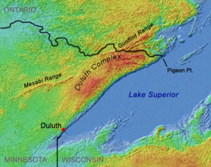
, Canada. The Gunflint Iron Range is the linear black formation labeled G, the Mesabi Iron Range is the jagged black linear formation labeled F and Cuyuna Iron Range is the two black spots labeled E. The gabbro
of the Duluth Complex
, intruded during the formation of the Midcontinent Rift, separates the Mesabi and Gunflint iron ranges; it is shown by the speckled area wrapping around the western end of Lake Superior
.
Banded-iron formations
are iron formations which formed about 2,000 million years ago and were first described in the Lake Superior region. Sediments associated with the last stage of the Great Lakes tectonic zone
contain banded-iron formations. These sediments were deposited for two hundred million years and extend intermittently along roughly the same trend as the Great Lakes tectonic zone, from Minnesota into eastern Ontario
, Canada, and through upper Wisconsin and Michigan. They are characterized by bands of iron compounds and chert
. Enough oxygen
had accumulated in seawater
so that dissolved iron
was oxidized; iron reacts with oxygen to form compounds that precipitate
out – including hematite
, limonite
and siderite
. These iron compounds precipitated from the seawater in varying proportions with chert, producing banded-iron formations. These iron formations are abundant in the Lake Superior region. The Sudbury Impact
event occurred 1,850 million years ago; it is theorized that this caused the end of the banded-iron deposits. The results of the impact affected concentrations of dissolved oxygen in the sea; the accumulation of banded-iron formations suddenly ended .
The Gunflint Range consists of a basal conglomerate
, then the Gunflint Iron formation and the Gunflint Chert
with the Rove Formation deposited on top. The Mesabi Range consists of the basal Pokegama Quartzite layer, then the Biwabik Iron Formation with the Virginia Formation deposited on top. The Vermilion Range consists of the basal Ely Greenstone, then the Soudan
Iron formation with various granites on top. The Cuyuna Range consists of the basal North Range group, then the Trommald Formation with the Thomson Formation deposited on top.
and continued through the Great Lakes tectonic zone rupture from 2,200 to 1,850 million years ago.
The Animikie Group formations are in east-central and northeastern Minnesota, and the Thunder Bay District of Northern Ontario; they are geographically divided into the Gunflint Range, the Mesabi and Vermilion ranges, and the Cuyuna Range. The Animikie Basin was an extensional basin which developed over a basement consisting of the 2,750- to 2,600-million-year-old Superior province to the north and the 3,600-million-year-old Minnesota River Valley subprovince to the south. The extension was caused by the east-northeast–trending Great Lakes tectonic zone; it separates the Superior province from the Minnesota River Valley subprovince. The sediments were deformed, metamorphosed and intruded by the plutonic rocks of the 1860 ± 50-million-year-old Penokean orogeny
.
The rocks of the Animikie Basin form a sequence up to 10 km (6.2 mi) thick and show a complete transition from a stable shelf environment to deep-water conditions. Irregularities in the basement influenced the thickness of the sequence. The 700 km (435 mi) by 400 km (248.5 mi) basin is an elongated oval parallel to and straddling the Great Lakes tectonic zone.
. A sea invaded central Minnesota and extended eastward through northern Wisconsin and the Upper Peninsula of Michigan. Sediments composed of quartz
-rich sand were deposited along the shoreline of this sea; these were succeeded by thick iron-rich layers and eventually kilometers of mud
and muddy sand. The deposition of sedimentary strata on top of the Archean
basement formed the Animikie Group.
The next tectonic event was the Great Lakes tectonic zone which began with compression caused by the collision of the Superior province and the Minnesota River Valley subprovince during the Algoman orogeny about 2,700 million years ago; it continued as a pulling apart (extensional) rift
from 2,450 to 2,100 million years ago, followed by a second compression
which deformed the rocks in the Lake Superior region during the Penokean orogeny which lasted from 1,900 to 1,850 million years ago. The first deposits occurred during the initial stages of extension of the Great Lakes tectonic zone in the continental crust. As the crust
expanded it thinned, and magma was intruded
through fissures
in the thinned crust. Sedimentation stopped during this transitional period because the elevation was now above sea level. During later stages, the spreading center was adding oceanic crust – which is heavier than continental crust – so the area subsided, seas returned, and the second layer of sediments were deposited unconformably on the basin fill.
 The third tectonic event was the Penokean orogeny which is dated 1,850 million years ago. The intense, northward-directed compression folded the shale
and greywacke
of the southernmost unit – the Thomson Formation – and metamorphosed the shale into slate
. The Animikie strata on the Gunflint and Mesabi ranges were far enough away so they escaped this deformation and metamorphism; they contain some of the oldest unmetamorphosed sedimentary deposits in the world.
About a fourth tectonic event occurred in the Lake Superior region. A hotspot
of magma from the earth’s mantle beneath present-day Lake Superior rose, causing the crust to dome and break apart. This zone of crustal thinning and fracturing is the Midcontinent Rift System
; it extends in a boomerang shape for over 2200 km (1,367 mi) from northeastern Kansas northward through Iowa, under the Twin Cities of Minnesota, beneath Lake Superior, and then south through the eastern Upper Peninsula of Michigan and beneath the central Lower Peninsula of Michigan. As the crust was being stretched thin and more magma flowed out from below, the center of the rift was continuously subsiding. The vast quantities of rising magma created a vacuum under the crust, the weight of the solidified magma on the surface caused the crust to subside into that vacuum so the edges of the rift tilted toward the center. The rifting stopped after a few million years; one reason could be that the Grenville orogeny
stopped the rift process when that collision occurred. Subsidence continued for several million years after the lava flows had ceased; immense volumes of sediments – sand, gravel and mud – were eroded off the barren landscape into the still-sinking basin along the rift axis. As much as 8 km (5 mi) of sedimentary rocks accumulated in the center before the sinking stopped and the region stabilized. A north-northeast trending branch of the Midcontinent Rift System separated the Animikie Basin into two distinct segments; the present-day Animikie Group and the Marquette Range Supergroup; the historical name for the Marquette Range Supergroup is the Animikie Series.
 Oceanic sediments associated with the last stage of the Great Lakes tectonic zone contain the banded-iron formations. Banded-iron formations are iron formations which formed about 2,000 million years ago and were first described in the Lake Superior region. They are characterized by interlayers – bands – of iron minerals and chert (quartz). These sediments were laid down for two hundred million years and extend intermittently along roughly the same trend as the Great Lakes tectonic zone, from Minnesota into eastern Canada, and through upper Wisconsin and Michigan.
and iron. Evidence for the change in oxygen levels is that the sediments of the earlier Archean are dark brown and black caused by unoxidized carbon, iron sulfide
, and other elements and compounds. As oxygen levels increased in the atmosphere and oceans, the sediments changed. In the late Archean, sediments went through a transitional stage with the banded-iron formations; after this transition they demonstrate an oxygen-rich environment – shown by iron oxide-stained siltstones or mudstones called red beds
.
Enough oxygen had accumulated in seawater so that dissolved iron – which had earlier eroded from the surrounding land – was oxidized. Oxygenated water has low levels of dissolved iron because iron reacts with oxygen to form compounds that precipitate out; the compounds include hematite
(Fe2O3), limonite
(Fe2O3·2H2O) and siderite
(FeCO3). These iron compounds precipitated from the sea water in varying proportions with chert, producing banded-iron formations. Banded-iron formations occur in several ranges around the margins of this basin, five of which contained sufficient concentrations of iron to be economically mined. These banded-iron formations have been one of the world’s greatest sources of iron ore since mining began in the area during the late 19th century. Major iron formations in different parts of the basin represent either nearly contemporaneous shelf sedimentation on either side of the main basin, or deposits formed simultaneously in isolated sub-basins of the main basin.
impact ejecta
. Radiometric dating
reveals that this layer was deposited between 1,878 and 1,836 million years ago. The Sudbury Impact
event – which occurred 650 to 875 km (403.9 to 543.7 mi) to the east 1,850 ± 1 million years ago – is the likely ejecta source, making these the oldest ejecta linked to a specific impact. Additional evidence indicates a 16 km (10 mi) diameter meteorite collided with earth in the current-day vicinity of Sudbury, Ontario, Canada. The meteorite vaporized and created a 240 km (149.1 mi) wide crater. Earthquakes shattered the ground hundreds of kilometers away and within seconds ejecta (cloud of ash, rock fragments, gases and droplets of molten rock) began to spread around the globe. It is estimated that at ground zero the earthquake would have registered 10.2 on the Richter magnitude scale
.
To put the Sudbury meteorite impact in perspective, the Chicxulub impact
on the Yucatán Peninsula occurred with the impact of a 16.5 km (10.3 mi) diameter comet. The kinetic energy from this impact probably generated earthquakes registering 13 on the Richter scale. The results of this impact caused the worldwide extinction of many species (including dinasaurs). The Sudbury Impact would have also had global ramifications; it is conjectured that this caused the end of the banded-iron deposits. The results of the impact fundamentally affected concentrations of dissolved oxygen in the sea; the accumulation of marine sediments (the banded-iron formations) were almost instantaneously shut down and banded-iron formation buildups suddenly ended about . In northeastern Minnesota these iron-banded formations lie immediately under the ejecta layer.
One use of the impact layer is as a precise timeline that ties together well-known stratigraphic
sequences of the various geographically separated iron ranges. The Sudbury Impact layer lies at a horizon that records a significant change in the character of sediments across the region. The layer marks the end of a major period of banded-iron formation deposition that was succeeded by deposition of fine clastic rocks – commonly black shales.
source. This change is interpreted to be from the Pembine-Wausau island arc as it closed in from the south just before its collision during the Penokean orogeny. Sediments shedding off the island arc settled on top of the previously deposited sequences.
 The Gunflint Range is a mountain range in northeastern Minnesota, U.S., and western Ontario, Canada. The Gunflint and Mesabi ranges form a belt extending from the upper Mississippi River
to the extreme northeast part of Minnesota and into Canada to Thunder Bay
. The two ranges are separated by the 1,099-million-year-old Duluth Complex which was formed during the Midcontinent Rift.
The Gunflint Iron Formation is 1,878 ± 2 million years old. It lies on top of a basal conglomerate, unlike the Biwabik Iron Formation which was deposited on top of the Pokegama Quartzite in the Mesabi Range, and the Cuyuna Iron Formation which was deposited on top of the Mille Lacs and North ranges. It is 150 km (93.2 mi) long, less than 8 km (5 mi) wide, and 135 to 170 m (442.9 to 557.7 ft) thick. This iron formation lies in a northeasterly-trending belt; most of it lies in Ontario.
The upper sedimentary layer is the 1,800- to 1,600-million-year-old Rove Formation. The seas and laid down the shales, slates and mudstone
s of the Rove Formation
. Because the formation is on the northern part of the Animikie Basin these rocks escaped the crustal deformation from the Penokean orogeny that characterizes the equivalent strata of the Thomson Formation; this left the Rove Formation unmetamorphosed and lying flat. These are some of the oldest undeformed and unmetamorphosed
sedimentary rocks in North America. The dikes and sills within the Rove Formation were intruded during the Midcontinent Rift.
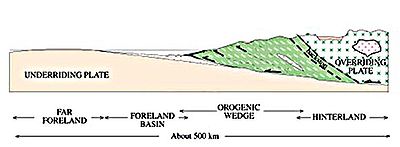
The three different formations exposed along the Mesabi Iron Range were deposited along the leading edge of a foredeep basin – the Animikie Basin – which transgressed north over the Archean craton during the Penokean orogeny. Deposition of the basal Pokegama Quartzite, the medial Biwabik Iron Formation and the upper Virginia Formation's sediments represent near-shore, shelf and slope environments, respectively. These three layers were formed 2,500 to 1,600 million years ago.
Pokegama Quartzite occupies the lowest level of the Mesabi Range sequence and is younger than 2,500 million years old. It contains shale, siltstone
and sandstone
, which were deposited in a flat environment of the sea that covered the Archean surface. It is 0 to 153 m (0 to 502 ft) thick, with an average of 60 m (196.9 ft).
The 1,900- to 1,850-million-year-old Biwabik Iron Formation is a narrow belt of iron-rich strata that extends east-northeast for 200 km (124.3 mi); its thickness varies from 60 to 600 m (196.9 to 1,968.5 ft), its average may be 305 m (1,000.7 ft). It has four primary subdivisions: the Lower Cherty (which was deposited upon the Pokegama Quartzite), the Lower Slatey, the Upper Cherty and the Upper Slaty (which the Virginia Formation rests upon). The two ore-producing layers are the Upper and Lower cherty subdivisions; cherts make up the bulk of the formation. The east end of the Biwabik Iron Formation was metamorphosed by the heat of the Duluth Complex.
The 1,850-million-year-old Virginia Formation is the sedimentary layer on top of the Biwabik Iron Range and forms the footwall of the 1,100-million-year-old Duluth Complex in the Ely – Hoyt Lakes region. The Virginia formation consists of black to dark grey argillite
, which does not crop out in natural exposures.
.png) The Vermilion Range is north of the Mesabi Iron Range; it is 154 km (95.7 mi) long and ranges from 3 to 30 km (1.9 to 18.6 mi) wide. Its basal unit is the Ely Greenstone layer. Ely Greenstone consists of igneous rocks which were metamophosed by the gabbro
The Vermilion Range is north of the Mesabi Iron Range; it is 154 km (95.7 mi) long and ranges from 3 to 30 km (1.9 to 18.6 mi) wide. Its basal unit is the Ely Greenstone layer. Ely Greenstone consists of igneous rocks which were metamophosed by the gabbro
of the Duluth Complex. The Ely Greenstone is a belt consisting chiefly of metamorphosed volcanic rocks which have been deformed so that original bedding stands nearly vertical. In the Soudan area the Ely Greenstone has been tightly folded and slightly overturned southward into the Tower-Soudan anticline
, and bedding is inclined 70-80° to the north. The volcanic rocks of the Ely Greenstone are divided into a lower and upper sequence; the upper and lower volcanic sequences are separated by the Soudan Iron Formation – a 50 to 3000 m (164 to 9,842.5 ft) thick unit that is transitional with the Ely Greenstone – which consists chiefly of banded iron-formation. The Soudan Iron Formation is in the western part of the Vermilion Range. It is in narrow belts, and consists of cherts, hematite, magnetite
and small amounts of pyrite
. The narrow belts trend east–northeast with the widest part to the southwest. These iron-bearing rocks are of sedimentary origin which overlie an igneous series. The iron formation is tightly folded with greenstone
. and is overlain by granite
s in the Vermilion
, Trout, Burntside
, Basswood and Saganaga lake areas.
The North Range Group is the basal unit for the Cuyuna Range. It is divided into three structural units: South Range (The rocks of the South Range are assigned to the Mille Lacs group.), North Range and the Emily District each with its own characteristic stratigraphy and structure. The rocks of the South and North ranges are separated by a major north-verging thrust fault
, and both are overlain unconformably by the Emily District. The rocks of the North Range – assigned to the North Range Group, – are divided into three formations, the Mahnomen, Trommald and Rabbit Lake. The North Range of the Cuyuna Range was regionally metamorphosed during the Penokean orogeny, which peaked between 1,870 and 1,850 million years ago. The iron ore of the Cuyuna is a Lake Superior-type iron-formation similar to other iron formations in the region.
The Mahnomen Formation has a lower member, which lacks iron oxide components, and an upper member dominated by beds of iron oxide argillite and lean iron-formation interlayered with non-iron oxide argillite, siltstone and quartzose sandstone. The Trommald Formation – the principal iron formation of the North Range – is a chemically precipitated unit. This formation is 14 to 150 m (45.9 to 492.1 ft) thick and is composed of carbonate-silicate iron formations and associated manganese oxide deposits. The iron oxidised to form hematite. The uppermost Rabbit Lake Formation has a lower member of black mudstone inserted with beds of iron formation and units of volcanogenic origin; and an upper member of slate, carbonaceous mudstone, greywacke and thin units of iron-rich strata.
.png) The top sedimentary layer is the Thomson Formation which was deposited 1,880 to 1,870 million years ago and deformed by the Penokean orogeny 1,850 million years ago. The formation contains folded and metamorphosed greywacke, siltstone, mudstone and slate which were originally deposited in the sea as horizontal beds of mud and sand; the Penokean orogeny subjected the rocks to intense compression from the south. This folded the layers into east-west trending anticlines and syncline
The top sedimentary layer is the Thomson Formation which was deposited 1,880 to 1,870 million years ago and deformed by the Penokean orogeny 1,850 million years ago. The formation contains folded and metamorphosed greywacke, siltstone, mudstone and slate which were originally deposited in the sea as horizontal beds of mud and sand; the Penokean orogeny subjected the rocks to intense compression from the south. This folded the layers into east-west trending anticlines and syncline
s, and compressed the muddy beds into slate, a metamorphic rock. The Thomson Formation has steeply dipping beds of greywacke, siltstone and slate. Several basalt
ic dike
s, from the lava of the Midcontinent Rift period, cut across the Thomson Formation slate and greywackes. Most of these dikes trend in a northeasterly direction; they represent magma that rose in fissures in the crust.
on the north shore of Lake Huron
in Ontario overlies an Archean basement. On the map it is the formation north of both Lake Huron and the Grenville Front Tectonic Zone
. Huronian sedimentary rocks form a 300 km (186.4 mi) east–west fold belt and reach a thickness of 12 km (7.5 mi) near Lake Huron. Deposition of sediments began 2,450 to 2,219 million years ago and continued until 1,850 to 1,800 million years ago when the rocks were deformed and metamorphosed during the Penokean orogeny. The supergroup's sedimentary layers are divided into lower and upper sequences. The lower sequence is subdivided into the Elliot Lake, Hourg Lake and Quirke Lake groups; the upper sequence is the Cobalt Group. The lower sequences were deposited in a continental rift basin and the upper sequence was deposited in a stable passive margin.
Metasediment
In geology, metasediment is sediment or sedimentary rock that shows evidence of having been subjected to metamorphism. The overall composition of a metasediment can be used to identify the original sedimentary rock, even where they have been subject to high-grade metamorphism and intense...
ary rock, having been originally deposited between 2,500 and 1,800 million years ago within the Animikie Basin. This group of formations are geographically divided into the Gunflint Range
Gunflint Range
The Gunflint Range is an iron ore deposit in northern Minnesota in the United States and Northwestern Ontario, Canada. The range extends from the extreme northern portion of Cook County, Minnesota into Canada....
, the Mesabi
Mesabi Range
The Mesabi Iron Range is a vast deposit of iron ore and the largest of four major iron ranges in the region collectively known as the Iron Range of Minnesota. Discovered in 1866, it is the chief deposit of iron ore in the United States. The deposit is located in northeast Minnesota, largely in...
and Vermilion
Vermilion Range (Minnesota)
The Vermilion Range exists between Tower and Ely, Minnesota, and contains significant deposits of iron ore. The Vermilion, along with the Mesabi and Cuyuna Ranges, constitute the Iron Ranges of northern Minnesota which were deposited in the Animikie Group...
ranges, and the Cuyuna Range
Cuyuna Range
The Cuyuna Range is an iron range to the southwest of the Mesabi Range, largely within Crow Wing County, Minnesota. It lies along a line between Brainerd and Aitkin, although those communities are not mining towns....
. On the map the Animikie Group is the dark grey northeast-trending belt which ranges from south-central Minnesota
Minnesota
Minnesota is a U.S. state located in the Midwestern United States. The twelfth largest state of the U.S., it is the twenty-first most populous, with 5.3 million residents. Minnesota was carved out of the eastern half of the Minnesota Territory and admitted to the Union as the thirty-second state...
, U.S., up to Thunder Bay, Ontario
Thunder Bay, Ontario
Thunder Bay is a city in and the seat of Thunder Bay District, Ontario, Canada. It is the most populous municipality in Northwestern Ontario, and the second most populous in Northern Ontario after Greater Sudbury...
, Canada. The Gunflint Iron Range is the linear black formation labeled G, the Mesabi Iron Range is the jagged black linear formation labeled F and Cuyuna Iron Range is the two black spots labeled E. The gabbro
Gabbro
Gabbro refers to a large group of dark, coarse-grained, intrusive mafic igneous rocks chemically equivalent to basalt. The rocks are plutonic, formed when molten magma is trapped beneath the Earth's surface and cools into a crystalline mass....
of the Duluth Complex
Duluth Complex
The Duluth Complex, the related Beaver Bay Complex , and the associated North Shore Volcanic Group are rock formations which comprise much of the basement bedrock of the northeastern part of the U.S. state of Minnesota...
, intruded during the formation of the Midcontinent Rift, separates the Mesabi and Gunflint iron ranges; it is shown by the speckled area wrapping around the western end of Lake Superior
Lake Superior
Lake Superior is the largest of the five traditionally-demarcated Great Lakes of North America. It is bounded to the north by the Canadian province of Ontario and the U.S. state of Minnesota, and to the south by the U.S. states of Wisconsin and Michigan. It is the largest freshwater lake in the...
.
Banded-iron formations
Banded iron formation
Banded iron formations are distinctive units of sedimentary rock that are almost always of Precambrian age. A typical BIF consists of repeated, thin layers of iron oxides, either magnetite or hematite , alternating with bands of iron-poor shale and chert...
are iron formations which formed about 2,000 million years ago and were first described in the Lake Superior region. Sediments associated with the last stage of the Great Lakes tectonic zone
Great Lakes tectonic zone
During the Late Archean Eon the Algoman orogeny added landmass to the Superior province by volcanic activity and continental collision along a boundary that stretches from present-day South Dakota, U.S., into the Sudbury, Ontario, Canada, Lake Huron region....
contain banded-iron formations. These sediments were deposited for two hundred million years and extend intermittently along roughly the same trend as the Great Lakes tectonic zone, from Minnesota into eastern Ontario
Geography of Ontario
Ontario is located in East/Central Canada, bordered by the Great Lakes, Hudson Bay and James Bay. It is Canada's second largest province in total land area...
, Canada, and through upper Wisconsin and Michigan. They are characterized by bands of iron compounds and chert
Chert
Chert is a fine-grained silica-rich microcrystalline, cryptocrystalline or microfibrous sedimentary rock that may contain small fossils. It varies greatly in color , but most often manifests as gray, brown, grayish brown and light green to rusty red; its color is an expression of trace elements...
. Enough oxygen
Oxygen
Oxygen is the element with atomic number 8 and represented by the symbol O. Its name derives from the Greek roots ὀξύς and -γενής , because at the time of naming, it was mistakenly thought that all acids required oxygen in their composition...
had accumulated in seawater
Seawater
Seawater is water from a sea or ocean. On average, seawater in the world's oceans has a salinity of about 3.5% . This means that every kilogram of seawater has approximately of dissolved salts . The average density of seawater at the ocean surface is 1.025 g/ml...
so that dissolved iron
Iron oxide
Iron oxides are chemical compounds composed of iron and oxygen. All together, there are sixteen known iron oxides and oxyhydroxides.Iron oxides and oxide-hydroxides are widespread in nature, play an important role in many geological and biological processes, and are widely utilized by humans, e.g.,...
was oxidized; iron reacts with oxygen to form compounds that precipitate
Precipitation (chemistry)
Precipitation is the formation of a solid in a solution or inside anothersolid during a chemical reaction or by diffusion in a solid. When the reaction occurs in a liquid, the solid formed is called the precipitate, or when compacted by a centrifuge, a pellet. The liquid remaining above the solid...
out – including hematite
Hematite
Hematite, also spelled as haematite, is the mineral form of iron oxide , one of several iron oxides. Hematite crystallizes in the rhombohedral system, and it has the same crystal structure as ilmenite and corundum...
, limonite
Limonite
Limonite is an ore consisting in a mixture of hydrated iron oxide-hydroxide of varying composition. The generic formula is frequently written as FeO·nH2O, although this is not entirely accurate as limonite often contains a varying amount of oxide compared to hydroxide.Together with hematite, it has...
and siderite
Siderite
Siderite is a mineral composed of iron carbonate FeCO3. It takes its name from the Greek word σίδηρος sideros, “iron”. It is a valuable iron mineral, since it is 48% iron and contains no sulfur or phosphorus...
. These iron compounds precipitated from the seawater in varying proportions with chert, producing banded-iron formations. These iron formations are abundant in the Lake Superior region. The Sudbury Impact
Sudbury Basin
The Sudbury Basin, also known as Sudbury Structure or the Sudbury Nickel Irruptive, is a major geologic structure in Ontario, Canada. It is the second-largest known impact crater or astrobleme on Earth, as well as one of the oldest....
event occurred 1,850 million years ago; it is theorized that this caused the end of the banded-iron deposits. The results of the impact affected concentrations of dissolved oxygen in the sea; the accumulation of banded-iron formations suddenly ended .
The Gunflint Range consists of a basal conglomerate
Conglomerate (geology)
A conglomerate is a rock consisting of individual clasts within a finer-grained matrix that have become cemented together. Conglomerates are sedimentary rocks consisting of rounded fragments and are thus differentiated from breccias, which consist of angular clasts...
, then the Gunflint Iron formation and the Gunflint Chert
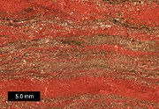
Gunflint Chert
The Gunflint chert is a sequence of banded iron formation rocks that are exposed in the Gunflint Range of northern Minnesota and northwestern Ontario along the north shore of Lake Superior. The black layers in the sequence contain microfossils that are 1.9 to 2.3 billion years in age. Stromatolite...
with the Rove Formation deposited on top. The Mesabi Range consists of the basal Pokegama Quartzite layer, then the Biwabik Iron Formation with the Virginia Formation deposited on top. The Vermilion Range consists of the basal Ely Greenstone, then the Soudan
Soudan Underground Mine State Park
The Soudan Underground Mine State Park is a Minnesota state park at the site of the Soudan Underground Mine, on the south shore of Lake Vermilion. The mine is known as Minnesota's oldest, deepest, and richest iron mine, and now hosts the Soudan Underground Laboratory. As the Soudan Iron Mine, it...
Iron formation with various granites on top. The Cuyuna Range consists of the basal North Range group, then the Trommald Formation with the Thomson Formation deposited on top.
Age, location and size
The Animikie Group sediments were deposited between 2,500 and 1,800 million years ago, in the Animikie Basin. Deposition of sediments began after the Algoman orogenyAlgoman orogeny
During the Late Archaen Eon repeated episodes of continental collisions, compressions and subductions generated a mountain-building episode known as the Algoman orogeny; it is known as the Kenoran orogeny in Canada. The Superior province and the Minnesota River Valley microcontinent collided about...
and continued through the Great Lakes tectonic zone rupture from 2,200 to 1,850 million years ago.
The Animikie Group formations are in east-central and northeastern Minnesota, and the Thunder Bay District of Northern Ontario; they are geographically divided into the Gunflint Range, the Mesabi and Vermilion ranges, and the Cuyuna Range. The Animikie Basin was an extensional basin which developed over a basement consisting of the 2,750- to 2,600-million-year-old Superior province to the north and the 3,600-million-year-old Minnesota River Valley subprovince to the south. The extension was caused by the east-northeast–trending Great Lakes tectonic zone; it separates the Superior province from the Minnesota River Valley subprovince. The sediments were deformed, metamorphosed and intruded by the plutonic rocks of the 1860 ± 50-million-year-old Penokean orogeny
Penokean orogeny
The Penokean orogeny was a mountain-building episode that occurred in the early Proterozoic about 1.85 to 1.84 billion years ago, in the area of North America that would eventually become Minnesota, Wisconsin, Michigan and Ontario...
.
The rocks of the Animikie Basin form a sequence up to 10 km (6.2 mi) thick and show a complete transition from a stable shelf environment to deep-water conditions. Irregularities in the basement influenced the thickness of the sequence. The 700 km (435 mi) by 400 km (248.5 mi) basin is an elongated oval parallel to and straddling the Great Lakes tectonic zone.
Development of Animikie Basin
Twenty-seven hundred million years ago the Algoman orogeny formed mountains; these bare mountains eroded for several hundred million years to a broad level peneplainPeneplain
A peneplain is a low-relief plain representing the final stage of fluvial erosion during times of extended tectonic stability. The existence of peneplains, and peneplanation as a geomorphological process, is not without controversy, due to a lack of contemporary examples and uncertainty in...
. A sea invaded central Minnesota and extended eastward through northern Wisconsin and the Upper Peninsula of Michigan. Sediments composed of quartz
Quartz
Quartz is the second-most-abundant mineral in the Earth's continental crust, after feldspar. It is made up of a continuous framework of SiO4 silicon–oxygen tetrahedra, with each oxygen being shared between two tetrahedra, giving an overall formula SiO2. There are many different varieties of quartz,...
-rich sand were deposited along the shoreline of this sea; these were succeeded by thick iron-rich layers and eventually kilometers of mud
Mud
Mud is a mixture of water and some combination of soil, silt, and clay. Ancient mud deposits harden over geological time to form sedimentary rock such as shale or mudstone . When geological deposits of mud are formed in estuaries the resultant layers are termed bay muds...
and muddy sand. The deposition of sedimentary strata on top of the Archean
Archean
The Archean , also spelled Archeozoic or Archæozoic) is a geologic eon before the Paleoproterozoic Era of the Proterozoic Eon, before 2.5 Ga ago. Instead of being based on stratigraphy, this date is defined chronometrically...
basement formed the Animikie Group.
The next tectonic event was the Great Lakes tectonic zone which began with compression caused by the collision of the Superior province and the Minnesota River Valley subprovince during the Algoman orogeny about 2,700 million years ago; it continued as a pulling apart (extensional) rift
Rift
In geology, a rift or chasm is a place where the Earth's crust and lithosphere are being pulled apart and is an example of extensional tectonics....
from 2,450 to 2,100 million years ago, followed by a second compression
Compression (geology)
In geology the term compression refers to a set of stresses directed toward the center of a rock mass. Compressive strength refers to the maximum compressive stress that can be applied to a material before failure occurs. When the maximum compressive stress is in a horizontal orientation, thrust...
which deformed the rocks in the Lake Superior region during the Penokean orogeny which lasted from 1,900 to 1,850 million years ago. The first deposits occurred during the initial stages of extension of the Great Lakes tectonic zone in the continental crust. As the crust
Crust (geology)
In geology, the crust is the outermost solid shell of a rocky planet or natural satellite, which is chemically distinct from the underlying mantle...
expanded it thinned, and magma was intruded
Intrusion
An intrusion is liquid rock that forms under Earth's surface. Magma from under the surface is slowly pushed up from deep within the earth into any cracks or spaces it can find, sometimes pushing existing country rock out of the way, a process that can take millions of years. As the rock slowly...
through fissures
Fissure vent
A fissure vent, also known as a volcanic fissure or simply fissure, is a linear volcanic vent through which lava erupts, usually without any explosive activity. The vent is usually a few meters wide and may be many kilometers long. Fissure vents can cause large flood basalts and lava channels...
in the thinned crust. Sedimentation stopped during this transitional period because the elevation was now above sea level. During later stages, the spreading center was adding oceanic crust – which is heavier than continental crust – so the area subsided, seas returned, and the second layer of sediments were deposited unconformably on the basin fill.
Shale
Shale is a fine-grained, clastic sedimentary rock composed of mud that is a mix of flakes of clay minerals and tiny fragments of other minerals, especially quartz and calcite. The ratio of clay to other minerals is variable. Shale is characterized by breaks along thin laminae or parallel layering...
and greywacke
Greywacke
Greywacke or Graywacke is a variety of sandstone generally characterized by its hardness, dark color, and poorly sorted angular grains of quartz, feldspar, and small rock fragments or lithic fragments set in a compact, clay-fine matrix. It is a texturally immature sedimentary rock generally found...
of the southernmost unit – the Thomson Formation – and metamorphosed the shale into slate
Slate
Slate is a fine-grained, foliated, homogeneous metamorphic rock derived from an original shale-type sedimentary rock composed of clay or volcanic ash through low-grade regional metamorphism. The result is a foliated rock in which the foliation may not correspond to the original sedimentary layering...
. The Animikie strata on the Gunflint and Mesabi ranges were far enough away so they escaped this deformation and metamorphism; they contain some of the oldest unmetamorphosed sedimentary deposits in the world.
About a fourth tectonic event occurred in the Lake Superior region. A hotspot
Hotspot (geology)
The places known as hotspots or hot spots in geology are volcanic regions thought to be fed by underlying mantle that is anomalously hot compared with the mantle elsewhere. They may be on, near to, or far from tectonic plate boundaries. There are two hypotheses to explain them...
of magma from the earth’s mantle beneath present-day Lake Superior rose, causing the crust to dome and break apart. This zone of crustal thinning and fracturing is the Midcontinent Rift System
Midcontinent Rift System
The Midcontinent Rift System or Keweenawan Rift is a long geological rift in the center of the North American continent and south-central part of the North American plate. It formed when the continent's core, the North American craton, began to split apart during the Mesoproterozoic era of the...
; it extends in a boomerang shape for over 2200 km (1,367 mi) from northeastern Kansas northward through Iowa, under the Twin Cities of Minnesota, beneath Lake Superior, and then south through the eastern Upper Peninsula of Michigan and beneath the central Lower Peninsula of Michigan. As the crust was being stretched thin and more magma flowed out from below, the center of the rift was continuously subsiding. The vast quantities of rising magma created a vacuum under the crust, the weight of the solidified magma on the surface caused the crust to subside into that vacuum so the edges of the rift tilted toward the center. The rifting stopped after a few million years; one reason could be that the Grenville orogeny
Grenville orogeny
The Grenville Orogeny was a long-lived Mesoproterozoic mountain-building event associated with the assembly of the supercontinent Rodinia. Its record is a prominent orogenic belt which spans a significant portion of the North American continent, from Labrador to Mexico, as well as to Scotland...
stopped the rift process when that collision occurred. Subsidence continued for several million years after the lava flows had ceased; immense volumes of sediments – sand, gravel and mud – were eroded off the barren landscape into the still-sinking basin along the rift axis. As much as 8 km (5 mi) of sedimentary rocks accumulated in the center before the sinking stopped and the region stabilized. A north-northeast trending branch of the Midcontinent Rift System separated the Animikie Basin into two distinct segments; the present-day Animikie Group and the Marquette Range Supergroup; the historical name for the Marquette Range Supergroup is the Animikie Series.
Banded-iron formations
Change in atmospheric oxygen levels
Banded-iron sediments record the introduction of abundant free oxygen into earth's atmosphere. Life played an important role in changing atmospheric conditions by releasing free oxygen as a waste product of photosynthesis. Free oxygen was taken up by elements with strong affinities for it – hydrogen, carbonOxocarbon
An oxocarbon or oxide of carbon is an inorganic compound consisting only of carbon and oxygen.The simplest and most common oxocarbons are carbon monoxide and carbon dioxide...
and iron. Evidence for the change in oxygen levels is that the sediments of the earlier Archean are dark brown and black caused by unoxidized carbon, iron sulfide
Iron sulfide
Iron sulfide or Iron sulphide refers to a chemical compound of iron and sulfur with a wide range of stoechiometric formulae and different crystalline structures.-Natural minerals:By increasing order of stability:...
, and other elements and compounds. As oxygen levels increased in the atmosphere and oceans, the sediments changed. In the late Archean, sediments went through a transitional stage with the banded-iron formations; after this transition they demonstrate an oxygen-rich environment – shown by iron oxide-stained siltstones or mudstones called red beds
Red beds
Red beds are sedimentary rocks, which typically consist of sandstone, siltstone, and shale that are predominantly red in color due to the presence of ferric oxides. Frequently, these red-colored sedimentary strata locally contain thin beds of conglomerate, marl, limestone, or some combination of...
.
Enough oxygen had accumulated in seawater so that dissolved iron – which had earlier eroded from the surrounding land – was oxidized. Oxygenated water has low levels of dissolved iron because iron reacts with oxygen to form compounds that precipitate out; the compounds include hematite
Hematite
Hematite, also spelled as haematite, is the mineral form of iron oxide , one of several iron oxides. Hematite crystallizes in the rhombohedral system, and it has the same crystal structure as ilmenite and corundum...
(Fe2O3), limonite
Limonite
Limonite is an ore consisting in a mixture of hydrated iron oxide-hydroxide of varying composition. The generic formula is frequently written as FeO·nH2O, although this is not entirely accurate as limonite often contains a varying amount of oxide compared to hydroxide.Together with hematite, it has...
(Fe2O3·2H2O) and siderite
Siderite
Siderite is a mineral composed of iron carbonate FeCO3. It takes its name from the Greek word σίδηρος sideros, “iron”. It is a valuable iron mineral, since it is 48% iron and contains no sulfur or phosphorus...
(FeCO3). These iron compounds precipitated from the sea water in varying proportions with chert, producing banded-iron formations. Banded-iron formations occur in several ranges around the margins of this basin, five of which contained sufficient concentrations of iron to be economically mined. These banded-iron formations have been one of the world’s greatest sources of iron ore since mining began in the area during the late 19th century. Major iron formations in different parts of the basin represent either nearly contemporaneous shelf sedimentation on either side of the main basin, or deposits formed simultaneously in isolated sub-basins of the main basin.
Effect of the Sudbury Impact on atmospheric oxygen levels
A 25 to 70 cm (9.8 to 27.6 in) thick lateral layer between the (meta)sedimentary Gunflint Iron Formation and overlying Rove Formation, and between the Biwabik Iron Formation and overlying Virginia Formation has evidence that the layer contains hypervelocityHypervelocity
The term hypervelocity usually refers to a very high velocity, approximately over 3,000 meters per second . In particular, it refers to velocities so high that the strength of materials upon impact is very small compared to inertial stresses. Thus, even metals behave like fluids under hypervelocity...
impact ejecta
Impact event
An impact event is the collision of a large meteorite, asteroid, comet, or other celestial object with the Earth or another planet. Throughout recorded history, hundreds of minor impact events have been reported, with some occurrences causing deaths, injuries, property damage or other significant...
. Radiometric dating
Radiometric dating
Radiometric dating is a technique used to date materials such as rocks, usually based on a comparison between the observed abundance of a naturally occurring radioactive isotope and its decay products, using known decay rates...
reveals that this layer was deposited between 1,878 and 1,836 million years ago. The Sudbury Impact
Sudbury Igneous Complex
The Sudbury Igneous Complex is a 1,844 million year-old impact melt sheet in Greater Sudbury, Northern Ontario, Canada. It is part of the Sudbury Basin impact structure, and is classified as a lopolith.-References:*...
event – which occurred 650 to 875 km (403.9 to 543.7 mi) to the east 1,850 ± 1 million years ago – is the likely ejecta source, making these the oldest ejecta linked to a specific impact. Additional evidence indicates a 16 km (10 mi) diameter meteorite collided with earth in the current-day vicinity of Sudbury, Ontario, Canada. The meteorite vaporized and created a 240 km (149.1 mi) wide crater. Earthquakes shattered the ground hundreds of kilometers away and within seconds ejecta (cloud of ash, rock fragments, gases and droplets of molten rock) began to spread around the globe. It is estimated that at ground zero the earthquake would have registered 10.2 on the Richter magnitude scale
Richter magnitude scale
The expression Richter magnitude scale refers to a number of ways to assign a single number to quantify the energy contained in an earthquake....
.
To put the Sudbury meteorite impact in perspective, the Chicxulub impact
Chicxulub Crater
The Chicxulub crater is an ancient impact crater buried underneath the Yucatán Peninsula in Mexico. Its center is located near the town of Chicxulub, after which the crater is named...
on the Yucatán Peninsula occurred with the impact of a 16.5 km (10.3 mi) diameter comet. The kinetic energy from this impact probably generated earthquakes registering 13 on the Richter scale. The results of this impact caused the worldwide extinction of many species (including dinasaurs). The Sudbury Impact would have also had global ramifications; it is conjectured that this caused the end of the banded-iron deposits. The results of the impact fundamentally affected concentrations of dissolved oxygen in the sea; the accumulation of marine sediments (the banded-iron formations) were almost instantaneously shut down and banded-iron formation buildups suddenly ended about . In northeastern Minnesota these iron-banded formations lie immediately under the ejecta layer.
One use of the impact layer is as a precise timeline that ties together well-known stratigraphic
Stratigraphy
Stratigraphy, a branch of geology, studies rock layers and layering . It is primarily used in the study of sedimentary and layered volcanic rocks....
sequences of the various geographically separated iron ranges. The Sudbury Impact layer lies at a horizon that records a significant change in the character of sediments across the region. The layer marks the end of a major period of banded-iron formation deposition that was succeeded by deposition of fine clastic rocks – commonly black shales.
End of deposition
Sedimentation styles of the passive margin changed as deposition came to a close. The sedimentary environment recorded near the end changed from deep water shales derived from Archean rocks to coarser clastic rocks derived from a younger ProterozoicProterozoic
The Proterozoic is a geological eon representing a period before the first abundant complex life on Earth. The name Proterozoic comes from the Greek "earlier life"...
source. This change is interpreted to be from the Pembine-Wausau island arc as it closed in from the south just before its collision during the Penokean orogeny. Sediments shedding off the island arc settled on top of the previously deposited sequences.
Gunflint Range
Upper Mississippi River
The Upper Mississippi River is the portion of the Mississippi River upstream of Cairo, Illinois, United States. From the headwaters at Lake Itasca, Minnesota, the river flows approximately 2000 kilometers to Cairo, where it is joined by the Ohio River to form the Lower Mississippi...
to the extreme northeast part of Minnesota and into Canada to Thunder Bay
Thunder Bay
-In Canada:Thunder Bay is the name of three places in the province of Ontario, Canada along Lake Superior:*Thunder Bay District, Ontario, a district in Northwestern Ontario*Thunder Bay, a city in Thunder Bay District*Thunder Bay, Unorganized, Ontario...
. The two ranges are separated by the 1,099-million-year-old Duluth Complex which was formed during the Midcontinent Rift.
The Gunflint Iron Formation is 1,878 ± 2 million years old. It lies on top of a basal conglomerate, unlike the Biwabik Iron Formation which was deposited on top of the Pokegama Quartzite in the Mesabi Range, and the Cuyuna Iron Formation which was deposited on top of the Mille Lacs and North ranges. It is 150 km (93.2 mi) long, less than 8 km (5 mi) wide, and 135 to 170 m (442.9 to 557.7 ft) thick. This iron formation lies in a northeasterly-trending belt; most of it lies in Ontario.
The upper sedimentary layer is the 1,800- to 1,600-million-year-old Rove Formation. The seas and laid down the shales, slates and mudstone
Mudstone
Mudstone is a fine grained sedimentary rock whose original constituents were clays or muds. Grain size is up to 0.0625 mm with individual grains too small to be distinguished without a microscope. With increased pressure over time the platey clay minerals may become aligned, with the...
s of the Rove Formation
History of the Rove Formation
The Rove Formation is located in the upper northeastern part of Cook County, Minnesota, United States, and extends into Ontario, Canada. It is the youngest of the many Animikie layers, a layer of sedimentary rocks....
. Because the formation is on the northern part of the Animikie Basin these rocks escaped the crustal deformation from the Penokean orogeny that characterizes the equivalent strata of the Thomson Formation; this left the Rove Formation unmetamorphosed and lying flat. These are some of the oldest undeformed and unmetamorphosed
Metamorphism
Metamorphism is the solid-state recrystallization of pre-existing rocks due to changes in physical and chemical conditions, primarily heat, pressure, and the introduction of chemically active fluids. Mineralogical, chemical and crystallographic changes can occur during this process...
sedimentary rocks in North America. The dikes and sills within the Rove Formation were intruded during the Midcontinent Rift.
Mesabi Range
The Mesabi Range is over 320 km (198.8 mi) long and less than 16 kilometre wid – its typical width is 4 km (2.5 mi) – and 110 to 240 m (360.9 to 787.4 ft) thick. Its natural ore is hematite- or geothite-rich leached iron formation; natural ores contain up to 50% iron and less than 10% silica. These thick sedimentary layers contain millions of tons of iron and minor ores which have been mined in the Great Lakes region since before the turn of the 20th century. Sedimentation ended when the Penokean orogeny began .The three different formations exposed along the Mesabi Iron Range were deposited along the leading edge of a foredeep basin – the Animikie Basin – which transgressed north over the Archean craton during the Penokean orogeny. Deposition of the basal Pokegama Quartzite, the medial Biwabik Iron Formation and the upper Virginia Formation's sediments represent near-shore, shelf and slope environments, respectively. These three layers were formed 2,500 to 1,600 million years ago.
Pokegama Quartzite occupies the lowest level of the Mesabi Range sequence and is younger than 2,500 million years old. It contains shale, siltstone
Siltstone
Siltstone is a sedimentary rock which has a grain size in the silt range, finer than sandstone and coarser than claystones.- Description :As its name implies, it is primarily composed of silt sized particles, defined as grains 1/16 - 1/256 mm or 4 to 8 on the Krumbein phi scale...
and sandstone
Sandstone
Sandstone is a sedimentary rock composed mainly of sand-sized minerals or rock grains.Most sandstone is composed of quartz and/or feldspar because these are the most common minerals in the Earth's crust. Like sand, sandstone may be any colour, but the most common colours are tan, brown, yellow,...
, which were deposited in a flat environment of the sea that covered the Archean surface. It is 0 to 153 m (0 to 502 ft) thick, with an average of 60 m (196.9 ft).
The 1,900- to 1,850-million-year-old Biwabik Iron Formation is a narrow belt of iron-rich strata that extends east-northeast for 200 km (124.3 mi); its thickness varies from 60 to 600 m (196.9 to 1,968.5 ft), its average may be 305 m (1,000.7 ft). It has four primary subdivisions: the Lower Cherty (which was deposited upon the Pokegama Quartzite), the Lower Slatey, the Upper Cherty and the Upper Slaty (which the Virginia Formation rests upon). The two ore-producing layers are the Upper and Lower cherty subdivisions; cherts make up the bulk of the formation. The east end of the Biwabik Iron Formation was metamorphosed by the heat of the Duluth Complex.
The 1,850-million-year-old Virginia Formation is the sedimentary layer on top of the Biwabik Iron Range and forms the footwall of the 1,100-million-year-old Duluth Complex in the Ely – Hoyt Lakes region. The Virginia formation consists of black to dark grey argillite
Argillite
An argillite is a fine-grained sedimentary rock composed predominantly of indurated clay particles. Argillaceous rocks are basically lithified muds and oozes. They contain variable amounts of silt-sized particles. The argillites grade into shale when the fissile layering typical of shale is...
, which does not crop out in natural exposures.
Vermilion Range
Gabbro
Gabbro refers to a large group of dark, coarse-grained, intrusive mafic igneous rocks chemically equivalent to basalt. The rocks are plutonic, formed when molten magma is trapped beneath the Earth's surface and cools into a crystalline mass....
of the Duluth Complex. The Ely Greenstone is a belt consisting chiefly of metamorphosed volcanic rocks which have been deformed so that original bedding stands nearly vertical. In the Soudan area the Ely Greenstone has been tightly folded and slightly overturned southward into the Tower-Soudan anticline
Anticline
In structural geology, an anticline is a fold that is convex up and has its oldest beds at its core. The term is not to be confused with antiform, which is a purely descriptive term for any fold that is convex up. Therefore if age relationships In structural geology, an anticline is a fold that is...
, and bedding is inclined 70-80° to the north. The volcanic rocks of the Ely Greenstone are divided into a lower and upper sequence; the upper and lower volcanic sequences are separated by the Soudan Iron Formation – a 50 to 3000 m (164 to 9,842.5 ft) thick unit that is transitional with the Ely Greenstone – which consists chiefly of banded iron-formation. The Soudan Iron Formation is in the western part of the Vermilion Range. It is in narrow belts, and consists of cherts, hematite, magnetite
Magnetite
Magnetite is a ferrimagnetic mineral with chemical formula Fe3O4, one of several iron oxides and a member of the spinel group. The chemical IUPAC name is iron oxide and the common chemical name is ferrous-ferric oxide. The formula for magnetite may also be written as FeO·Fe2O3, which is one part...
and small amounts of pyrite
Pyrite
The mineral pyrite, or iron pyrite, is an iron sulfide with the formula FeS2. This mineral's metallic luster and pale-to-normal, brass-yellow hue have earned it the nickname fool's gold because of its resemblance to gold...
. The narrow belts trend east–northeast with the widest part to the southwest. These iron-bearing rocks are of sedimentary origin which overlie an igneous series. The iron formation is tightly folded with greenstone
Greenstone belt
Greenstone belts are zones of variably metamorphosed mafic to ultramafic volcanic sequences with associated sedimentary rocks that occur within Archaean and Proterozoic cratons between granite and gneiss bodies....
. and is overlain by granite
Granite
Granite is a common and widely occurring type of intrusive, felsic, igneous rock. Granite usually has a medium- to coarse-grained texture. Occasionally some individual crystals are larger than the groundmass, in which case the texture is known as porphyritic. A granitic rock with a porphyritic...
s in the Vermilion
Lake Vermilion
Lake Vermilion is a freshwater lake in northeastern Minnesota, United States. The Ojibwe originally called the lake Onamuni, which means "Lake of the Sunset Glow". French fur traders translated this to the Latin word Vermilion, which is a red pigment...
, Trout, Burntside
Burntside Lake
Burntside Lake is a lake located northwest of Ely, Minnesota, in St. Louis County, Minnesota. Its western boundary adjoins the Boundary Waters Canoe Area Wilderness on Tamarack Creek....
, Basswood and Saganaga lake areas.
Cuyuna Range
The Cuyuna Iron Range is southwest of the Mesabi Range in east-central Minnesota; it is 110 km (68.4 mi) by 32 km (19.9 mi) of tightly folded iron formations. Its thickness ranges from 0 to 135 m (0 to 442.9 ft). Two sequences – the Mille Lacs and North ranges – underlie the southern part of the Animike Group. The Mille Lacs Group is more than 2,197 ± 39 million years old.The North Range Group is the basal unit for the Cuyuna Range. It is divided into three structural units: South Range (The rocks of the South Range are assigned to the Mille Lacs group.), North Range and the Emily District each with its own characteristic stratigraphy and structure. The rocks of the South and North ranges are separated by a major north-verging thrust fault
Thrust fault
A thrust fault is a type of fault, or break in the Earth's crust across which there has been relative movement, in which rocks of lower stratigraphic position are pushed up and over higher strata. They are often recognized because they place older rocks above younger...
, and both are overlain unconformably by the Emily District. The rocks of the North Range – assigned to the North Range Group, – are divided into three formations, the Mahnomen, Trommald and Rabbit Lake. The North Range of the Cuyuna Range was regionally metamorphosed during the Penokean orogeny, which peaked between 1,870 and 1,850 million years ago. The iron ore of the Cuyuna is a Lake Superior-type iron-formation similar to other iron formations in the region.
The Mahnomen Formation has a lower member, which lacks iron oxide components, and an upper member dominated by beds of iron oxide argillite and lean iron-formation interlayered with non-iron oxide argillite, siltstone and quartzose sandstone. The Trommald Formation – the principal iron formation of the North Range – is a chemically precipitated unit. This formation is 14 to 150 m (45.9 to 492.1 ft) thick and is composed of carbonate-silicate iron formations and associated manganese oxide deposits. The iron oxidised to form hematite. The uppermost Rabbit Lake Formation has a lower member of black mudstone inserted with beds of iron formation and units of volcanogenic origin; and an upper member of slate, carbonaceous mudstone, greywacke and thin units of iron-rich strata.
Syncline
In structural geology, a syncline is a fold, with younger layers closer to the center of the structure. A synclinorium is a large syncline with superimposed smaller folds. Synclines are typically a downward fold, termed a synformal syncline In structural geology, a syncline is a fold, with younger...
s, and compressed the muddy beds into slate, a metamorphic rock. The Thomson Formation has steeply dipping beds of greywacke, siltstone and slate. Several basalt
Basalt
Basalt is a common extrusive volcanic rock. It is usually grey to black and fine-grained due to rapid cooling of lava at the surface of a planet. It may be porphyritic containing larger crystals in a fine matrix, or vesicular, or frothy scoria. Unweathered basalt is black or grey...
ic dike
Dike (geology)
A dike or dyke in geology is a type of sheet intrusion referring to any geologic body that cuts discordantly across* planar wall rock structures, such as bedding or foliation...
s, from the lava of the Midcontinent Rift period, cut across the Thomson Formation slate and greywackes. Most of these dikes trend in a northeasterly direction; they represent magma that rose in fissures in the crust.
Summary of Huronian and Marquette Range supergroups
The Huronian and Marquette Range supergroups are similar sedimentary groups to the Animikie Group; all three are in the Great Lakes region. Rifting of continental plates create sedimentary basins; the largest of these basins in the Great Lakes area are the Animikie Group in Minnesota, the Marquette Range Supergroup in northern Michigan and Wisconsin, and the Huronian Supergroup in eastern Ontario.Huronian Supergroup
The Huronian SupergroupHuronian Supergroup
The Huronian Supergroup is a Proterozoic geologic feature of the Superior craton of the Canadian Shield in Ontario and Quebec. It extends from the city of Sault Ste. Marie in the west to the Ontario-Quebec border to the east....
on the north shore of Lake Huron
Lake Huron
Lake Huron is one of the five Great Lakes of North America. Hydrologically, it comprises the larger portion of Lake Michigan-Huron. It is bounded on the east by the Canadian province of Ontario and on the west by the state of Michigan in the United States...
in Ontario overlies an Archean basement. On the map it is the formation north of both Lake Huron and the Grenville Front Tectonic Zone
Grenville Front Tectonic Zone
The Grenville Front Tectonic Zone is a geological feature in Eastern Canada that separates the Superior craton from rocks of the Grenville orogeny. It is a large tectonic zone of the Canadian Shield, extending from the northern shore of Lake Huron through Ontario and Quebec to Labrador, a distance...
. Huronian sedimentary rocks form a 300 km (186.4 mi) east–west fold belt and reach a thickness of 12 km (7.5 mi) near Lake Huron. Deposition of sediments began 2,450 to 2,219 million years ago and continued until 1,850 to 1,800 million years ago when the rocks were deformed and metamorphosed during the Penokean orogeny. The supergroup's sedimentary layers are divided into lower and upper sequences. The lower sequence is subdivided into the Elliot Lake, Hourg Lake and Quirke Lake groups; the upper sequence is the Cobalt Group. The lower sequences were deposited in a continental rift basin and the upper sequence was deposited in a stable passive margin.