

History of the Rove Formation
Encyclopedia
The Rove Formation is located in the upper northeastern part of Cook County, Minnesota
, United States, and extends into Ontario
, Canada. It is the youngest of the many Animikie layers, a layer of sedimentary rocks.
Before the Rove sediments were laid down, during the Archean Eon, the Algoman orogeny
added landmass along a border from South Dakota
to the Lake Huron region; this boundary is the Great Lakes tectonic zone
. Several million years later a thin layer of hypervelocity impact ejecta from the Sudbury impact event was deposited between the Rove and the older, underlying, Gunflint Iron Formation
; it is estimated that at ground zero the earthquake generated by the meteor impact would have registered 10.2 on the Richter scale.
During the Middle Precambrian
a shallow inland sea covered much of the Lake Superior
region and formed the Animikie Group
, layers of sedimentary rocks overlying 2700-million-year-old Archean rocks. The Rove Formation is the youngest of the many Animikie layers.
After the Rove sediments were deposited, the Penokean orogeny
added more land mass by accretion that occurred from the south. A few hundred million years later the proto-North American continent nearly split in half along the Midcontinent Rift zone, which is a bow-shaped rift extending from northeast Kansas, arcing through the present-day Lake Superior Basin and then angling southeast through Michigan. Then came a period of advancing and retreating glaciers. The more resistant diabase
sills
and dikes
remained, while the softer shales were bulldozed away by the glaciers. The north path of glaciation is transverse to the general trend on the valleys and ridges.
As a result of erosion of sandstone
and the erosion-resistant sills and dikes, the topography in Minnesota has repeated parallel hills and valleys. The tightly packed lakes in the narrow valleys are long and narrow, and they orient from the east to west. The cliffs in these narrow valleys are the habitat to several rare plants which prefer living in narrow cliff areas in a sub-Arctic climate. In Ontario the Rove Formation is overlain by a thick diabase cap.
of northeastern Minnesota, U.S., and extends into Ontario, Canada. In Minnesota it occurs along the U.S.-Ontario border from Gunflint Lake to Pigeon Point (both in northeastern Cook County) and northward into Canada. Pigeon Point is the most eastern part of Minnesota; it is a diabase sill about 152 m (498.7 ft) thick. Both the north and south coasts of the point expose Rove slates under and over the sill. Within the sill, rates of cooling and gravity have created an interesting distribution of rock types.
The visible formation is in Minnesota and contains many east-west oriented ridges and valleys. Many lakes in this 5 to 8 km (3.1 to 5 mi) wide band along the Canadian border are in the elongated east-west valleys; included are Caribou, Clearwater, Crocodile, Daniels, Duncan, Dunn, Hungry Jack, Iron, Loon, Moose, Pine, Portage and South. In Ontario the Rove Formation is overlaid by a thick diabase sill.
 The Archean Eon lasted from until approximately .
 The Algoman orogeny occurred 2800 to , and it marks the end of the crust-building Archean Eon. There were several episodes of continental collision
, compression and subduction
which resulted in mountain building during this time. Orogenic events are characterized by extensive metaphorism, granitic extrusions and unconformities. The Algoman orogeny added landmass along a border from South Dakota to the Lake Huron region; this boundary is the Great Lakes tectonic zone (GLTZ).
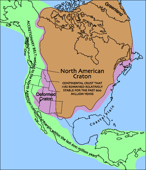
Northeast Minnesota has 2700-million-year-ago exposed rocks formed during volcanic activity that was in the form of seepage of lava from rifts in the sea floor. These lava flows began to rise up out of the ancient ocean to form the Superior craton; the Superior craton later assembled into the Canadian shield
, which became part of the North American craton. The Superior province is the largest preserved fragment of Archean crust, and the Canadian shield is the nucleus of the North American craton.
of Lake Superior, mainly in Minnesota. Approximately the northwestern two-thirds lies to the northwest of the shoreline; the southeastern third lies to the southeast of the shoreline (so is under Lake Superior's waters).
During the Middle Precambrian a shallow inland sea covered much of the Lake Superior region and formed the Animikie Group, which are layers of sedimentary rocks which unconformably overlies 2700-million-year-old Archean rocks. This group contains both the Rove and Gunflint Iron formations. The Rove Formation is the youngest of the many Animikie layers; it consists of gently tilted fine-grained sediments. It is composed of greywackes and black shale
, and contains lower concentrations of iron and taconite
than the underlying Gunflint Iron Formation does.
The Rove Formation consists of a lower argillite
unit, a middle transition unit and an upper thin-bedded greywacke unit. The lower argillite unit is about 150 m (492.1 ft) thick; this layer contains fine-grained greywacke, and silty and graphitic
argillites. Greywacke is a sedimentary rock composed of a mixture of poorly sorted grains of sand, silt and clay particles. Argillite is a fine-grained sedimentary rock composed primarily of clay particles; they are essentially lithified muds and oozes. Greywacke is abundant in the middle unit and dominates the upper unit. The complete thickness of the upper two units is about 900 m (2,952.8 ft).
Gunter Faure and Jack Kovach, using Rb-Sr dating, determined the age to be 1635 ±24 million years old. The Resident Geologist Program, Geology of the Thunder Bay South District, reports an age of 1800 million years old.
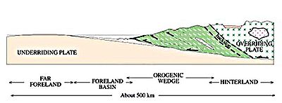
1880 to 1830 million years ago, when an oceanic island arc
called the Pembine–Wausau terrane collided with the southern margin of the Superior craton
. From 1880 to 1850 million years ago, the region was volcanically active. This volcanism ceased 1850 million years ago when a fragment of Archean
crust arrived from the South at the subduction zone. Collision of this Archean crust
in the south with the Superior craton
in the North caused a period of intense crustal shortening. Rocks of the Pembine–Wassau terrane were thrust
up over and onto the Superior craton, forming a mountain range that covered all but the northernmost portion of Lake Superior, crossed parts of three US states (south-central Minnesota
, northern Wisconsin
, and the Upper Peninsula of Michigan
), and continued to the southernmost tip of Ontario
, Canada
. Loading of the lithosphere
by these thrust sheets caused it to flex downwards, forming a foreland basin
at around 1850 million years ago in the south and 1835 million years ago in the north. The Rove Formation was deposited in the northern basin. In the southern basin, crustal thickening caused high-grade metamorphism of the sedimentary fill by 1830 million years ago. A series of post-orogenic pluton
s intruded
into the overlying rocks 1830 million years ago,; these plutons mark the end of the Penokean orogeny.
and feldspar
grains found within accretionary lapilli
, accreted grain clusters and spherule masses. These pieces of debris indicate that the layer contains hypervelocity impact ejecta. Zircon geochronologic
data shows that this layer formed 1878 to 1836 million years ago; the Sudbury Impact event occurred . Because of the closeness in dating and the nearness of the crater, the Sudbury Impact event is the likely source for the ejecta; these are the oldest ejecta linked to a specific event on Earth. In the Rove area this layer is about 7.6 m (24.9 ft) thick; this thin layer very likely represents the catastrophic events of a single day nearly .
Evidence indicates a 16 km (10 mi) diameter meteorite collided with Earth in the current-day vicinity of Sudbury, Ontario, Canada, about . The meteorite vaporized and created a 240 km (149.1 mi) wide crater (this is the second-largest impact depression on Earth). This impact is 770 km (478.5 mi) east of the Minnesota-Ontario border of the Rove Formation. Earthquakes shattered the ground hundreds of miles away and within seconds ejecta (cloud of ash, rock fragments, gases and droplets of molten rock) began to spread around the globe. It is estimated that at ground zero the earthquake would have registered 10.2 on the Richter scale. Seas covered the Rove Formation area and the Sudbury impact generated huge tsunamis.
To put the Sudbury meteorite impact in perspective, the Chicxulub impact
on the Yucatán Peninsula occurred ; the results of this impact caused the worldwide extinction of many species (including dinosaurs).
The Sudbury Impact would have had global ramifications; it is conjectured that this caused the end of the iron deposits. The impact fundamentally affected concentrations of dissolved oxygen in the sea; the accumulation of marine sediments (known as banded-iron formations) were almost instantaneously shut down. Banded-iron formations are massive deposits rich in iron oxides; they accumulated at several periods in the Earth's geologic past. One extended episode of banded-iron formation buildup suddenly ended about . In northeastern Minnesota these banded-iron formations lie immediately under the ejecta layer. Minnesota's Iron Range
is composed of this layer of banded-iron formation.
Most of the impact layer in the Rove area consists of beccia, a mixture of rock fragments which ripped loose from the sea floor during the earthquakes. The tsunamis jumbled the loosened bedrock and ejecta together; over time this layer was buried by younger sediments, cemented together and fused by molten rock to form a solid layer. Ejecta from the Sudbury Impact was found in May 2007 on the Gunflint Trail in Cook County, Minnesota. Geologists Mark Jirsa and Paul Weiblen from the University of Minnesota took advantage of the burnt-over landscape resulting from the intense, hot Ham Lake fire to explore the newly exposed geology along the Gunflint Trail. Jirsa picked up some rocks which turned out to be ash and debris from the 1100 km (683.5 mi) distant impact site; this is the farthest distance that Sudbury detrita has been found.
The Midcontinent Rift is the largest-known continental rift
in the world. The rift began as a hot spot
of basaltic magma underneath the Lake Superior region; it extruded layers of lava up to 20 km (12.4 mi) thick and extending up to 100 km (62.1 mi) on either side of the rift. The deposited lava along the North Shore of Lake Superior is 7620 m (5 mi) thick.
This was a fast-spreading rift; the resulting basalts show little interaction with the then-existing rock. These immense volumes of mafic
lava were generated in two major pulses, mostly via a hot mantle plume
. Along the North Shore of Lake Superior, one can see the solidified lava (igneous rock) most everywhere. In the Rove region the magma didn't reach the surface; it intruded into fractures in the formation and slowly cooled to become diabase (rather than basalt
). These solidified bodies are the Pigeon River
and Logan Intrusion diabases.
The continent didn't split into two because the Grenville province (a microcontinent) was converging with the proto-North American continent to the east. This convergence applied compressional forces to the rift, preventing the complete splitting apart of the proto-North American continent.
This rift was the last of volcanic or mountain-building activity in present-day Minnesota. The solidified lava flows have sagged, tilted and faulted; this created a basin up to 5000 m (16,404.2 ft) deep along the rift zone. Proto-Lake Superior filled the basin.
Puckwunge sandstone is exposed along an extremely narrow (feet-wide) band on the southwestern border of the Rove formation. The Puckwunge exposure begins at Raspberry Point within the Grand Portage National Monument on Lake Superior, Cook County, Minnesota, and extends for about 40 km (24.9 mi) inland to the northwest. The Rove Formation is located to the northeast of the Puckwunge sandstone; none is southwest of the border. The Rove Formation is bisected by several bands of Pigeon River Diabase; these bands are in a west-to-east orientation. The bands of Pigeon River Diabase do extend southwesterly past the Puckwunge Formation.
Period began about and continues today. This is the period of advancing and retreating glacier
s. The Rove region has multiple tilted layers of volcanic rocks and easily eroded shale. The more resistant diabase dikes and sills remained, while the softer shales were bulldozed away by the glaciers. These former shale valleys filled with water, forming the many lakes in the region. The character of the slates made them especially well suited for glacial quarrying, much more so than the contiguous sills. A cuesta
– a ridge formed by gently tilted sedimentary rock layers – topography had developed and was dominated by major east-west valleys with a few pronounced gaps in the intervening ridges.
The Rainy Lobe of the Wisconsin glaciation was the most recent of the glaciation events, and it retreated about 10,000 years ago. Glacial scratches and grooves in Rove rocks indicate a north or somewhat east-of-north glacial movement. This direction is transverse to the general trend on the valleys and ridges. The lakes in the Rove Formation area are unique from other well-known linear bedrock lakes in North America because their long axes lie transverse to the general movement of the glaciers.
When continental glaciers moved over the Rove Formation area, the ice was a hundreds of meters thick and its surface sloped gently southward from the Patrician center to the north. The base of the ice sheet encountered the cuesta topography relief of a few hundred feet. Because the ice over the valleys would be thicker than the ice over the ridges, obstructed extrusion flow would operate and resulted in the removal of the easily quarried slates of the valleys. The ridges would not be appreciably eroded, partly because the ice would be thinner over the ridges and therefore less plastic, and partly because of the resistance of the diabase to both quarrying and abrasion by the ice.
The weight of the ice sheet compressed the land and created depressions. As the glacier retreated, the weight and pressure were relieved from the surface of the land and the land rebounded; the rebound process continues, and is estimated to be 100 m (328.1 ft).
A portage
was necessary from the shore of Lake Superior past the High Falls. Southwest of the mouth of the Pigeon River is Grand Portage Bay; about 1.6 km (0.994196378639691 mi) inland there is a gap through the surrounding hills and bluffs which provides a gradual ascent to Cascade Falls. The river is navigable by canoe beyond the Cascade Falls. The Sioux and Chippewa created a 14.5 km (9 mi) long portage from Grand Portage Bay to bypass the three falls and several kilometers of turbulent river up to the Cascade Falls, probably by following animal trails. The French called this trail the Great Portage because it was so long.
The first-known non-native visitors were French-speaking people from France and eastern Canada who started to explore the area in about 1655. They were looking for the Northwest Passage
and to trade for furs, particularly beaver pelts. Beaver pelts were in demand for European fashion during the 17th and 18th centuries. The Grand Portage was on the major fur trade
route of the 18th century and was the first of more than 40 portages along the fur trade route. The French-Canadian voyageurs
would carry two 40 kg (88.2 lb) packs from the main storage depot at Grand Portage Bay along the trail to their smaller storage depot at Fort Charlotte; it took a few hours. In 1784 Grand Portage Bay became the headquarters for the North West Company
. The post was abandoned in 1803 when the North West Company moved north.
at Russell Point [about 16 km (10 mi) south of Thunder Bay
] is a Logan sill of diabase over the softer Rove Formation metasediments. It is one of the many flat-topped, steep-sided mesas along Lake Superior's northwestern shore south of Thunder Bay that are collectively known as the Nor'Wester Mountains
.
In Minnesota the Rove Formation area shows an interesting relationship of bedrock to topography with its valley-and-ridge landscape. There are several series of steep, east-west oriented valleys which were created by the erosion of the exposed shale. The diabase-capped ridges between the valleys slope gently to the south (4° to 15° from the horizontal); the northern faces are precipitous, they rise 60 to 140 m (196.9 to 459.3 ft) above deep, cold lakes, creating an asymmetrical cross-section profile. The asymmetrical cross section of the ridges is the result of bands of massive, poorly jointed rock alternating with highly jointed rock units. The valleys contain glacially quarried bedrock lakes; they are also asymmetrical in cross section because of the same structural elements which control the ridge shapes. Most of the lakes show an asymmetrical bottom configuration, showing a steep subaqueous slope on the south shore. The northern-facing cliffs provide the habitat for a few species of endangered flora. The Rove Formation has landscape features that are not found elsewhere in Minnesota.
Most of the valleys are occupied by chains of elongate lakes, many of which are bordered by solid rock on all sides. Many of the east-west valleys terminate abruptly at either one or both ends when the bordering sills merge together. The elevation of the lakes range from Rose Lake's 465 m (1,525.6 ft) to Loon Lake's 532 m (1,745.4 ft) above sea level. Lakes on the opposite sides of a single ridge may differ in surface elevation by as much as 60 m (196.9 ft). Many of the rock-bound lakes have a depth of about 30 m (98.4 ft); a few are deeper than 61 m (200.1 ft).
A topographic map shows that the majority of the interconnected complex of tightly packed lakes with their valley-and-ridge landscape is primarily in Minnesota; the border of the landscape is the Minnesota-Canadian border. This border is composed of the Pigeon River, and these Rove Formation lakes (going east to west): South Fowl, North Fowl, Moose, Mountain, Watap, Rose, South, Little North and Gunflint. The border runs approximately through the center of the lengths of these lakes. The only Rove-typical east-west oriented lakes lying in Ontario are Arrow and North lakes.
The preglacial drainage pattern
was controlled by the rock structure. Ver Steeg reconstructed a preglacial drainage pattern that shows major streams flowing east in the slate belts. Short tributaries and short north-south segments of the major streams cut across ridges which formed small gaps that are still present.
The Laurentian Continental Divide
is within the formation. Between North Lake, Ontario, and South Lake, Minnesota, is a low saddle of land right on the border; this is the divide. North Lake drains into the Rainy River and then to Hudson Bay. South Lake drains into the Pigeon River and then to Lake Superior.
Topsoils are thin and poor because the glaciers had abraded down to the bedrock. The soils are clayey silt.
this is the Rove Slate Bedrock Complex Landtype Association. The sedimentary and diabase rocks are calcareous
; they produce a more basic, nutrient-rich soil compared to the poorer soils typical of the Canadian shield. The Royal River drains Royal Lake [which is about 1.2 km (3,937 ft) east of South Fowl Lake] into John Lake, both in Minnesota. The relatively rich soils, particularly in the Royal River drainage area, along with steep, moist, north-facing cliffs provide the habitat
for these rare plants. For over a century this landtype association has been recognized as being ecologically and botanically unique; it harbors a rare assemblage of plants, including the rarest plants in Minnesota. Virtually all of the known sensitive plant species in this landscape association occur on the north side of the cliffs or in the Royal River drainage.
Six vascular plant
s are unique in that they are at the extreme edge of their range or are disjunct from the main range of their species. They are the Maidenhair spleenwort (Asplenium trichomanes
L.), in Minnesota six small populations of 20 to 40 plants have been found in the Rove area; Ross's (or Short) sedge (Carex
rossi), only three populations are known to exist in the Rove area; Large-leaved sandwort (Moehringia macrophylla
or Arenaria macrophylla), evidence indicates that this is a very rare species with limited distribution and restrictive environmental needs; Sticky locoweed
(Oxytropis borealis viscida), is restricted to a single cliff in Cook County; Encrusted saxifrage (Saxifraga paniculata
neogaea), 11 populations are known to exist in the Rove formation; and Smooth Woodsia (Woodsia glabella), there are small, isolated populations in the Rove Formation.
During two sensitive plant surveys conducted in June and July 2003, and July 2004, a Superior National Forest
sensitive plant, Canada Yew (Taxus canadensis
), was found; and a state-listed species of concern, Blunt-fruited sweet cicely (Osmorhiza depauperata
), has only four populations within 30 km (19 mi) of each other. Minnesota's Department of Natural Resources lists these vascular plants as being threatened: Rocky Mountain woodsia (Woodsia scopulina
ssp. laurentiana), there are few isolated populations in the formation; and Holboell's rock-cress (Arabis
holboellii var. retrofracta), rare in Ontario and Minnesota. Minnesota's Department of Natural Resources lists the Nodding saxifrage (Saxifraga cernua) as endangered, one source refers it to being "very rare" and that Cook County has Minnesota's single colony with about a dozen plants – the entire population occupies less than a 1 square metre – so it is vulnerable to singular events which would alter its habitat.
Cook County, Minnesota
Northern Minnesota offers extreme winter weather. While the averages are low, the extremes provide more details. A third of the year is below freezing . Of those days, 21 are below zero degrees Fahrenheit .-External links:...
, United States, and extends into Ontario
Ontario
Ontario is a province of Canada, located in east-central Canada. It is Canada's most populous province and second largest in total area. It is home to the nation's most populous city, Toronto, and the nation's capital, Ottawa....
, Canada. It is the youngest of the many Animikie layers, a layer of sedimentary rocks.
Before the Rove sediments were laid down, during the Archean Eon, the Algoman orogeny
Algoman orogeny
During the Late Archaen Eon repeated episodes of continental collisions, compressions and subductions generated a mountain-building episode known as the Algoman orogeny; it is known as the Kenoran orogeny in Canada. The Superior province and the Minnesota River Valley microcontinent collided about...
added landmass along a border from South Dakota
South Dakota
South Dakota is a state located in the Midwestern region of the United States. It is named after the Lakota and Dakota Sioux American Indian tribes. Once a part of Dakota Territory, South Dakota became a state on November 2, 1889. The state has an area of and an estimated population of just over...
to the Lake Huron region; this boundary is the Great Lakes tectonic zone
Great Lakes tectonic zone
During the Late Archean Eon the Algoman orogeny added landmass to the Superior province by volcanic activity and continental collision along a boundary that stretches from present-day South Dakota, U.S., into the Sudbury, Ontario, Canada, Lake Huron region....
. Several million years later a thin layer of hypervelocity impact ejecta from the Sudbury impact event was deposited between the Rove and the older, underlying, Gunflint Iron Formation
Gunflint Chert
The Gunflint chert is a sequence of banded iron formation rocks that are exposed in the Gunflint Range of northern Minnesota and northwestern Ontario along the north shore of Lake Superior. The black layers in the sequence contain microfossils that are 1.9 to 2.3 billion years in age. Stromatolite...
; it is estimated that at ground zero the earthquake generated by the meteor impact would have registered 10.2 on the Richter scale.
During the Middle Precambrian
Precambrian
The Precambrian is the name which describes the large span of time in Earth's history before the current Phanerozoic Eon, and is a Supereon divided into several eons of the geologic time scale...
a shallow inland sea covered much of the Lake Superior
Lake Superior
Lake Superior is the largest of the five traditionally-demarcated Great Lakes of North America. It is bounded to the north by the Canadian province of Ontario and the U.S. state of Minnesota, and to the south by the U.S. states of Wisconsin and Michigan. It is the largest freshwater lake in the...
region and formed the Animikie Group
Animikie Group
The Animikie Group is a geologic group composed of sedimentary and metasedimentary rock, having been originally deposited between 2,500 and 1,800 million years ago within the Animikie Basin. This group of formations are geographically divided into the Gunflint Range, the Mesabi and Vermilion...
, layers of sedimentary rocks overlying 2700-million-year-old Archean rocks. The Rove Formation is the youngest of the many Animikie layers.
After the Rove sediments were deposited, the Penokean orogeny
Penokean orogeny
The Penokean orogeny was a mountain-building episode that occurred in the early Proterozoic about 1.85 to 1.84 billion years ago, in the area of North America that would eventually become Minnesota, Wisconsin, Michigan and Ontario...
added more land mass by accretion that occurred from the south. A few hundred million years later the proto-North American continent nearly split in half along the Midcontinent Rift zone, which is a bow-shaped rift extending from northeast Kansas, arcing through the present-day Lake Superior Basin and then angling southeast through Michigan. Then came a period of advancing and retreating glaciers. The more resistant diabase
Diabase
Diabase or dolerite is a mafic, holocrystalline, subvolcanic rock equivalent to volcanic basalt or plutonic gabbro. In North American usage, the term diabase refers to the fresh rock, whilst elsewhere the term dolerite is used for the fresh rock and diabase refers to altered material...
sills
Sill (geology)
In geology, a sill is a tabular sheet intrusion that has intruded between older layers of sedimentary rock, beds of volcanic lava or tuff, or even along the direction of foliation in metamorphic rock. The term sill is synonymous with concordant intrusive sheet...
and dikes
Dike (geology)
A dike or dyke in geology is a type of sheet intrusion referring to any geologic body that cuts discordantly across* planar wall rock structures, such as bedding or foliation...
remained, while the softer shales were bulldozed away by the glaciers. The north path of glaciation is transverse to the general trend on the valleys and ridges.
As a result of erosion of sandstone
Sandstone
Sandstone is a sedimentary rock composed mainly of sand-sized minerals or rock grains.Most sandstone is composed of quartz and/or feldspar because these are the most common minerals in the Earth's crust. Like sand, sandstone may be any colour, but the most common colours are tan, brown, yellow,...
and the erosion-resistant sills and dikes, the topography in Minnesota has repeated parallel hills and valleys. The tightly packed lakes in the narrow valleys are long and narrow, and they orient from the east to west. The cliffs in these narrow valleys are the habitat to several rare plants which prefer living in narrow cliff areas in a sub-Arctic climate. In Ontario the Rove Formation is overlain by a thick diabase cap.
Location
The Rove Formation is in the Arrowhead RegionArrowhead Region
The Arrowhead Region is located in the northeastern part of the U.S. state of Minnesota, so called because of its pointed shape. The predominantly rural region encompasses of land area and comprises Carlton, Cook, Lake and St. Louis Counties. Its population at the 2000 census was 248,425 residents...
of northeastern Minnesota, U.S., and extends into Ontario, Canada. In Minnesota it occurs along the U.S.-Ontario border from Gunflint Lake to Pigeon Point (both in northeastern Cook County) and northward into Canada. Pigeon Point is the most eastern part of Minnesota; it is a diabase sill about 152 m (498.7 ft) thick. Both the north and south coasts of the point expose Rove slates under and over the sill. Within the sill, rates of cooling and gravity have created an interesting distribution of rock types.
The visible formation is in Minnesota and contains many east-west oriented ridges and valleys. Many lakes in this 5 to 8 km (3.1 to 5 mi) wide band along the Canadian border are in the elongated east-west valleys; included are Caribou, Clearwater, Crocodile, Daniels, Duncan, Dunn, Hungry Jack, Iron, Loon, Moose, Pine, Portage and South. In Ontario the Rove Formation is overlaid by a thick diabase sill.
Archean Eon
Continental collision
Continental collision is a phenomenon of the plate tectonics of Earth that occurs at convergent boundaries. Continental collision is a variation on the fundamental process of subduction, whereby the subduction zone is destroyed, mountains produced, and two continents sutured together...
, compression and subduction
Subduction
In geology, subduction is the process that takes place at convergent boundaries by which one tectonic plate moves under another tectonic plate, sinking into the Earth's mantle, as the plates converge. These 3D regions of mantle downwellings are known as "Subduction Zones"...
which resulted in mountain building during this time. Orogenic events are characterized by extensive metaphorism, granitic extrusions and unconformities. The Algoman orogeny added landmass along a border from South Dakota to the Lake Huron region; this boundary is the Great Lakes tectonic zone (GLTZ).
Northeast Minnesota has 2700-million-year-ago exposed rocks formed during volcanic activity that was in the form of seepage of lava from rifts in the sea floor. These lava flows began to rise up out of the ancient ocean to form the Superior craton; the Superior craton later assembled into the Canadian shield
Canadian Shield
The Canadian Shield, also called the Laurentian Plateau, or Bouclier Canadien , is a vast geological shield covered by a thin layer of soil that forms the nucleus of the North American or Laurentia craton. It is an area mostly composed of igneous rock which relates to its long volcanic history...
, which became part of the North American craton. The Superior province is the largest preserved fragment of Archean crust, and the Canadian shield is the nucleus of the North American craton.
Proterozoic Eon
The Proterozoic Eon lasted from untilAnimikie Group
The Animikie Basin, measuring 700 x 400 km (420 mi x 240 mi), is an elongated oval straddling the North ShoreNorth Shore (Lake Superior)
The North Shore of Lake Superior runs from Duluth, Minnesota, United States, at the southwestern end of the lake, to Thunder Bay and Nipigon, Ontario, Canada, in the north to Sault Ste. Marie, Ontario, in the east...
of Lake Superior, mainly in Minnesota. Approximately the northwestern two-thirds lies to the northwest of the shoreline; the southeastern third lies to the southeast of the shoreline (so is under Lake Superior's waters).
During the Middle Precambrian a shallow inland sea covered much of the Lake Superior region and formed the Animikie Group, which are layers of sedimentary rocks which unconformably overlies 2700-million-year-old Archean rocks. This group contains both the Rove and Gunflint Iron formations. The Rove Formation is the youngest of the many Animikie layers; it consists of gently tilted fine-grained sediments. It is composed of greywackes and black shale
Shale
Shale is a fine-grained, clastic sedimentary rock composed of mud that is a mix of flakes of clay minerals and tiny fragments of other minerals, especially quartz and calcite. The ratio of clay to other minerals is variable. Shale is characterized by breaks along thin laminae or parallel layering...
, and contains lower concentrations of iron and taconite
Taconite
Taconite is a variety of iron formation, an iron-bearing sedimentary rock, in which the iron minerals are interlayered with quartz, chert, or carbonate...
than the underlying Gunflint Iron Formation does.
The Rove Formation consists of a lower argillite
Argillite
An argillite is a fine-grained sedimentary rock composed predominantly of indurated clay particles. Argillaceous rocks are basically lithified muds and oozes. They contain variable amounts of silt-sized particles. The argillites grade into shale when the fissile layering typical of shale is...
unit, a middle transition unit and an upper thin-bedded greywacke unit. The lower argillite unit is about 150 m (492.1 ft) thick; this layer contains fine-grained greywacke, and silty and graphitic
Graphite
The mineral graphite is one of the allotropes of carbon. It was named by Abraham Gottlob Werner in 1789 from the Ancient Greek γράφω , "to draw/write", for its use in pencils, where it is commonly called lead . Unlike diamond , graphite is an electrical conductor, a semimetal...
argillites. Greywacke is a sedimentary rock composed of a mixture of poorly sorted grains of sand, silt and clay particles. Argillite is a fine-grained sedimentary rock composed primarily of clay particles; they are essentially lithified muds and oozes. Greywacke is abundant in the middle unit and dominates the upper unit. The complete thickness of the upper two units is about 900 m (2,952.8 ft).
Gunter Faure and Jack Kovach, using Rb-Sr dating, determined the age to be 1635 ±24 million years old. The Resident Geologist Program, Geology of the Thunder Bay South District, reports an age of 1800 million years old.
Penokean orogeny
The Penokean Mountain Range formed in the Penokean orogenyPenokean orogeny
The Penokean orogeny was a mountain-building episode that occurred in the early Proterozoic about 1.85 to 1.84 billion years ago, in the area of North America that would eventually become Minnesota, Wisconsin, Michigan and Ontario...
1880 to 1830 million years ago, when an oceanic island arc
Island arc
An island arc is a type of archipelago composed of a chain of volcanoes which alignment is arc-shaped, and which are situated parallel and close to a boundary between two converging tectonic plates....
called the Pembine–Wausau terrane collided with the southern margin of the Superior craton
Superior craton
The Superior craton forms the core of the Canadian Shield at the heart of the North American continent. It extends from Quebec in the east to eastern Manitoba in the west...
. From 1880 to 1850 million years ago, the region was volcanically active. This volcanism ceased 1850 million years ago when a fragment of Archean
Archean
The Archean , also spelled Archeozoic or Archæozoic) is a geologic eon before the Paleoproterozoic Era of the Proterozoic Eon, before 2.5 Ga ago. Instead of being based on stratigraphy, this date is defined chronometrically...
crust arrived from the South at the subduction zone. Collision of this Archean crust
Crust (geology)
In geology, the crust is the outermost solid shell of a rocky planet or natural satellite, which is chemically distinct from the underlying mantle...
in the south with the Superior craton
Superior craton
The Superior craton forms the core of the Canadian Shield at the heart of the North American continent. It extends from Quebec in the east to eastern Manitoba in the west...
in the North caused a period of intense crustal shortening. Rocks of the Pembine–Wassau terrane were thrust
Thrust fault
A thrust fault is a type of fault, or break in the Earth's crust across which there has been relative movement, in which rocks of lower stratigraphic position are pushed up and over higher strata. They are often recognized because they place older rocks above younger...
up over and onto the Superior craton, forming a mountain range that covered all but the northernmost portion of Lake Superior, crossed parts of three US states (south-central Minnesota
Minnesota
Minnesota is a U.S. state located in the Midwestern United States. The twelfth largest state of the U.S., it is the twenty-first most populous, with 5.3 million residents. Minnesota was carved out of the eastern half of the Minnesota Territory and admitted to the Union as the thirty-second state...
, northern Wisconsin
Wisconsin
Wisconsin is a U.S. state located in the north-central United States and is part of the Midwest. It is bordered by Minnesota to the west, Iowa to the southwest, Illinois to the south, Lake Michigan to the east, Michigan to the northeast, and Lake Superior to the north. Wisconsin's capital is...
, and the Upper Peninsula of Michigan
Upper Peninsula of Michigan
The Upper Peninsula of Michigan is the northern of the two major land masses that make up the U.S. state of Michigan. It is commonly referred to as the Upper Peninsula, the U.P., or Upper Michigan. It is also known as the land "above the Bridge" linking the two peninsulas. The peninsula is bounded...
), and continued to the southernmost tip of Ontario
Ontario
Ontario is a province of Canada, located in east-central Canada. It is Canada's most populous province and second largest in total area. It is home to the nation's most populous city, Toronto, and the nation's capital, Ottawa....
, Canada
Canada
Canada is a North American country consisting of ten provinces and three territories. Located in the northern part of the continent, it extends from the Atlantic Ocean in the east to the Pacific Ocean in the west, and northward into the Arctic Ocean...
. Loading of the lithosphere
Lithosphere
The lithosphere is the rigid outermost shell of a rocky planet. On Earth, it comprises the crust and the portion of the upper mantle that behaves elastically on time scales of thousands of years or greater.- Earth's lithosphere :...
by these thrust sheets caused it to flex downwards, forming a foreland basin
Foreland basin
A foreland basin is a depression that develops adjacent and parallel to a mountain belt. Foreland basins form because the immense mass created by crustal thickening associated with the evolution of a mountain belt causes the lithosphere to bend, by a process known as lithospheric flexure...
at around 1850 million years ago in the south and 1835 million years ago in the north. The Rove Formation was deposited in the northern basin. In the southern basin, crustal thickening caused high-grade metamorphism of the sedimentary fill by 1830 million years ago. A series of post-orogenic pluton
Pluton
A pluton in geology is a body of intrusive igneous rock that crystallized from magma slowly cooling below the surface of the Earth. Plutons include batholiths, dikes, sills, laccoliths, lopoliths, and other igneous bodies...
s intruded
Intrusion
An intrusion is liquid rock that forms under Earth's surface. Magma from under the surface is slowly pushed up from deep within the earth into any cracks or spaces it can find, sometimes pushing existing country rock out of the way, a process that can take millions of years. As the rock slowly...
into the overlying rocks 1830 million years ago,; these plutons mark the end of the Penokean orogeny.
Sudbury impact ejecta
At the base of the Rove Formation, between the Rove and the underlying Gunflint Iron Formation, there is a lateral layer of shocked quartzShocked quartz
Shocked quartz is a form of quartz that has a microscopic structure that is different from normal quartz. Under intense pressure , the crystalline structure of quartz will be deformed along planes inside the crystal...
and feldspar
Feldspar
Feldspars are a group of rock-forming tectosilicate minerals which make up as much as 60% of the Earth's crust....
grains found within accretionary lapilli
Lapilli
Lapilli is a size classification term for tephra, which is material that falls out of the air during a volcanic eruption or during some meteorite impacts. Lapilli means "little stones" in Latin. They are in some senses similar to ooids or pisoids in calcareous sediments.By definition lapilli range...
, accreted grain clusters and spherule masses. These pieces of debris indicate that the layer contains hypervelocity impact ejecta. Zircon geochronologic
Radiometric dating
Radiometric dating is a technique used to date materials such as rocks, usually based on a comparison between the observed abundance of a naturally occurring radioactive isotope and its decay products, using known decay rates...
data shows that this layer formed 1878 to 1836 million years ago; the Sudbury Impact event occurred . Because of the closeness in dating and the nearness of the crater, the Sudbury Impact event is the likely source for the ejecta; these are the oldest ejecta linked to a specific event on Earth. In the Rove area this layer is about 7.6 m (24.9 ft) thick; this thin layer very likely represents the catastrophic events of a single day nearly .
Evidence indicates a 16 km (10 mi) diameter meteorite collided with Earth in the current-day vicinity of Sudbury, Ontario, Canada, about . The meteorite vaporized and created a 240 km (149.1 mi) wide crater (this is the second-largest impact depression on Earth). This impact is 770 km (478.5 mi) east of the Minnesota-Ontario border of the Rove Formation. Earthquakes shattered the ground hundreds of miles away and within seconds ejecta (cloud of ash, rock fragments, gases and droplets of molten rock) began to spread around the globe. It is estimated that at ground zero the earthquake would have registered 10.2 on the Richter scale. Seas covered the Rove Formation area and the Sudbury impact generated huge tsunamis.
To put the Sudbury meteorite impact in perspective, the Chicxulub impact
Chicxulub Crater
The Chicxulub crater is an ancient impact crater buried underneath the Yucatán Peninsula in Mexico. Its center is located near the town of Chicxulub, after which the crater is named...
on the Yucatán Peninsula occurred ; the results of this impact caused the worldwide extinction of many species (including dinosaurs).
The Sudbury Impact would have had global ramifications; it is conjectured that this caused the end of the iron deposits. The impact fundamentally affected concentrations of dissolved oxygen in the sea; the accumulation of marine sediments (known as banded-iron formations) were almost instantaneously shut down. Banded-iron formations are massive deposits rich in iron oxides; they accumulated at several periods in the Earth's geologic past. One extended episode of banded-iron formation buildup suddenly ended about . In northeastern Minnesota these banded-iron formations lie immediately under the ejecta layer. Minnesota's Iron Range
Iron Range
The Iron Range is a region that makes up the northeastern section of Minnesota in the United States. "The Range", as it is known by locals, is a region with multiple distinct bands of iron ore...
is composed of this layer of banded-iron formation.
Most of the impact layer in the Rove area consists of beccia, a mixture of rock fragments which ripped loose from the sea floor during the earthquakes. The tsunamis jumbled the loosened bedrock and ejecta together; over time this layer was buried by younger sediments, cemented together and fused by molten rock to form a solid layer. Ejecta from the Sudbury Impact was found in May 2007 on the Gunflint Trail in Cook County, Minnesota. Geologists Mark Jirsa and Paul Weiblen from the University of Minnesota took advantage of the burnt-over landscape resulting from the intense, hot Ham Lake fire to explore the newly exposed geology along the Gunflint Trail. Jirsa picked up some rocks which turned out to be ash and debris from the 1100 km (683.5 mi) distant impact site; this is the farthest distance that Sudbury detrita has been found.
Midcontinent Rift
The Midcontinent Rift (also known as the Keewenawan Rift) began about ; it lasted for about 20 million years. After the Penokean Mountains had eroded away, the proto-North American continent nearly split in half along this rift zone. The 2000 km (1,242.7 mi) bow-shaped rift extended from northeast Kansas, through the southeast corner of Nebraska, diagonally northeast through Iowa, through Minnesota along the current Minnesota-Wisconsin border, arced through the present-day Lake Superior basin and angled southeast through Michigan.The Midcontinent Rift is the largest-known continental rift
Rift
In geology, a rift or chasm is a place where the Earth's crust and lithosphere are being pulled apart and is an example of extensional tectonics....
in the world. The rift began as a hot spot
Hotspot (geology)
The places known as hotspots or hot spots in geology are volcanic regions thought to be fed by underlying mantle that is anomalously hot compared with the mantle elsewhere. They may be on, near to, or far from tectonic plate boundaries. There are two hypotheses to explain them...
of basaltic magma underneath the Lake Superior region; it extruded layers of lava up to 20 km (12.4 mi) thick and extending up to 100 km (62.1 mi) on either side of the rift. The deposited lava along the North Shore of Lake Superior is 7620 m (5 mi) thick.
This was a fast-spreading rift; the resulting basalts show little interaction with the then-existing rock. These immense volumes of mafic
Mafic
Mafic is an adjective describing a silicate mineral or rock that is rich in magnesium and iron; the term is a portmanteau of the words "magnesium" and "ferric". Most mafic minerals are dark in color and the relative density is greater than 3. Common rock-forming mafic minerals include olivine,...
lava were generated in two major pulses, mostly via a hot mantle plume
Mantle plume
A mantle plume is a hypothetical thermal diapir of abnormally hot rock that nucleates at the core-mantle boundary and rises through the Earth's mantle. Such plumes were invoked in 1971 to explain volcanic regions that were not thought to be explicable by the then-new theory of plate tectonics. Some...
. Along the North Shore of Lake Superior, one can see the solidified lava (igneous rock) most everywhere. In the Rove region the magma didn't reach the surface; it intruded into fractures in the formation and slowly cooled to become diabase (rather than basalt
Basalt
Basalt is a common extrusive volcanic rock. It is usually grey to black and fine-grained due to rapid cooling of lava at the surface of a planet. It may be porphyritic containing larger crystals in a fine matrix, or vesicular, or frothy scoria. Unweathered basalt is black or grey...
). These solidified bodies are the Pigeon River
Pigeon River (Minnesota-Ontario)
The Pigeon River forms part of the US-Canada border between the State of Minnesota and the Province of Ontario west of Lake Superior. In pre-industrial times the river was a waterway of great importance for transportation and trade.-Geography:...
and Logan Intrusion diabases.
The continent didn't split into two because the Grenville province (a microcontinent) was converging with the proto-North American continent to the east. This convergence applied compressional forces to the rift, preventing the complete splitting apart of the proto-North American continent.
This rift was the last of volcanic or mountain-building activity in present-day Minnesota. The solidified lava flows have sagged, tilted and faulted; this created a basin up to 5000 m (16,404.2 ft) deep along the rift zone. Proto-Lake Superior filled the basin.
Puckwunge Formation
The Puckwunge Formation has buff to grey sandstone which comes from sediments deposited during the early stages of the Midcontinent rift; zircon dating shows a time period of 1200 to 1100 million years ago.Puckwunge sandstone is exposed along an extremely narrow (feet-wide) band on the southwestern border of the Rove formation. The Puckwunge exposure begins at Raspberry Point within the Grand Portage National Monument on Lake Superior, Cook County, Minnesota, and extends for about 40 km (24.9 mi) inland to the northwest. The Rove Formation is located to the northeast of the Puckwunge sandstone; none is southwest of the border. The Rove Formation is bisected by several bands of Pigeon River Diabase; these bands are in a west-to-east orientation. The bands of Pigeon River Diabase do extend southwesterly past the Puckwunge Formation.
Quaternary Period and glaciation
The QuaternaryQuaternary
The Quaternary Period is the most recent of the three periods of the Cenozoic Era in the geologic time scale of the ICS. It follows the Neogene Period, spanning 2.588 ± 0.005 million years ago to the present...
Period began about and continues today. This is the period of advancing and retreating glacier
Glacier
A glacier is a large persistent body of ice that forms where the accumulation of snow exceeds its ablation over many years, often centuries. At least 0.1 km² in area and 50 m thick, but often much larger, a glacier slowly deforms and flows due to stresses induced by its weight...
s. The Rove region has multiple tilted layers of volcanic rocks and easily eroded shale. The more resistant diabase dikes and sills remained, while the softer shales were bulldozed away by the glaciers. These former shale valleys filled with water, forming the many lakes in the region. The character of the slates made them especially well suited for glacial quarrying, much more so than the contiguous sills. A cuesta
Cuesta
In structural geology and geomorphology, a cuesta is a ridge formed by gently tilted sedimentary rock strata in a homoclinal structure. Cuestas have a steep slope, where the rock layers are exposed on their edges, called an escarpment or, if more steep, a cliff...
– a ridge formed by gently tilted sedimentary rock layers – topography had developed and was dominated by major east-west valleys with a few pronounced gaps in the intervening ridges.
The Rainy Lobe of the Wisconsin glaciation was the most recent of the glaciation events, and it retreated about 10,000 years ago. Glacial scratches and grooves in Rove rocks indicate a north or somewhat east-of-north glacial movement. This direction is transverse to the general trend on the valleys and ridges. The lakes in the Rove Formation area are unique from other well-known linear bedrock lakes in North America because their long axes lie transverse to the general movement of the glaciers.
When continental glaciers moved over the Rove Formation area, the ice was a hundreds of meters thick and its surface sloped gently southward from the Patrician center to the north. The base of the ice sheet encountered the cuesta topography relief of a few hundred feet. Because the ice over the valleys would be thicker than the ice over the ridges, obstructed extrusion flow would operate and resulted in the removal of the easily quarried slates of the valleys. The ridges would not be appreciably eroded, partly because the ice would be thinner over the ridges and therefore less plastic, and partly because of the resistance of the diabase to both quarrying and abrasion by the ice.
The weight of the ice sheet compressed the land and created depressions. As the glacier retreated, the weight and pressure were relieved from the surface of the land and the land rebounded; the rebound process continues, and is estimated to be 100 m (328.1 ft).
Human history
The Pigeon River forms the border between Minnesota and Ontario in this area. The first 32 km (19.9 mi) of the river is crooked, swift, interrupted by rapids and falls, and flows in places through a steep-walled canyon. The High Falls are 37 m (121.4 ft) high and presents an impassable obstacle to river travel. The Cascade Falls are further up the river. The soft shale erodes easily, leaving the Logan and Pigeon River diabases which create the waterfalls and cascades.A portage
Portage
Portage or portaging refers to the practice of carrying watercraft or cargo over land to avoid river obstacles, or between two bodies of water. A place where this carrying occurs is also called a portage; a person doing the carrying is called a porter.The English word portage is derived from the...
was necessary from the shore of Lake Superior past the High Falls. Southwest of the mouth of the Pigeon River is Grand Portage Bay; about 1.6 km (0.994196378639691 mi) inland there is a gap through the surrounding hills and bluffs which provides a gradual ascent to Cascade Falls. The river is navigable by canoe beyond the Cascade Falls. The Sioux and Chippewa created a 14.5 km (9 mi) long portage from Grand Portage Bay to bypass the three falls and several kilometers of turbulent river up to the Cascade Falls, probably by following animal trails. The French called this trail the Great Portage because it was so long.
The first-known non-native visitors were French-speaking people from France and eastern Canada who started to explore the area in about 1655. They were looking for the Northwest Passage
Northwest Passage
The Northwest Passage is a sea route through the Arctic Ocean, along the northern coast of North America via waterways amidst the Canadian Arctic Archipelago, connecting the Atlantic and Pacific Oceans...
and to trade for furs, particularly beaver pelts. Beaver pelts were in demand for European fashion during the 17th and 18th centuries. The Grand Portage was on the major fur trade
North American Fur Trade
The North American fur trade was the industry and activities related to the acquisition, exchange, and sale of animal furs in the North American continent. Indigenous peoples of different regions traded among themselves in the Pre-Columbian Era, but Europeans participated in the trade beginning...
route of the 18th century and was the first of more than 40 portages along the fur trade route. The French-Canadian voyageurs
Coureur des bois
A coureur des bois or coureur de bois was an independent entrepreneurial French-Canadian woodsman who traveled in New France and the interior of North America. They travelled in the woods to trade various things for fur....
would carry two 40 kg (88.2 lb) packs from the main storage depot at Grand Portage Bay along the trail to their smaller storage depot at Fort Charlotte; it took a few hours. In 1784 Grand Portage Bay became the headquarters for the North West Company
North West Company
The North West Company was a fur trading business headquartered in Montreal from 1779 to 1821. It competed with increasing success against the Hudson's Bay Company in what was to become Western Canada...
. The post was abandoned in 1803 when the North West Company moved north.
Present-day topography
In Ontario the shales and greywackes from the Rove Formation of the Animikie Group are overlain by a 60 m (196.9 ft) cap of diabase. This diabase cap a sill remnant, and most of the diabase is covered by a considerable thickness of mineral soil. The mesaMesa
A mesa or table mountain is an elevated area of land with a flat top and sides that are usually steep cliffs. It takes its name from its characteristic table-top shape....
at Russell Point [about 16 km (10 mi) south of Thunder Bay
Thunder Bay
-In Canada:Thunder Bay is the name of three places in the province of Ontario, Canada along Lake Superior:*Thunder Bay District, Ontario, a district in Northwestern Ontario*Thunder Bay, a city in Thunder Bay District*Thunder Bay, Unorganized, Ontario...
] is a Logan sill of diabase over the softer Rove Formation metasediments. It is one of the many flat-topped, steep-sided mesas along Lake Superior's northwestern shore south of Thunder Bay that are collectively known as the Nor'Wester Mountains
Nor'Wester Mountains
The Nor'Wester Mountains are a group of mountains immediately south of Thunder Bay, Ontario, Canada, located on the southern limits of the City of Thunder Bay and south of the Kaministiquia River....
.
In Minnesota the Rove Formation area shows an interesting relationship of bedrock to topography with its valley-and-ridge landscape. There are several series of steep, east-west oriented valleys which were created by the erosion of the exposed shale. The diabase-capped ridges between the valleys slope gently to the south (4° to 15° from the horizontal); the northern faces are precipitous, they rise 60 to 140 m (196.9 to 459.3 ft) above deep, cold lakes, creating an asymmetrical cross-section profile. The asymmetrical cross section of the ridges is the result of bands of massive, poorly jointed rock alternating with highly jointed rock units. The valleys contain glacially quarried bedrock lakes; they are also asymmetrical in cross section because of the same structural elements which control the ridge shapes. Most of the lakes show an asymmetrical bottom configuration, showing a steep subaqueous slope on the south shore. The northern-facing cliffs provide the habitat for a few species of endangered flora. The Rove Formation has landscape features that are not found elsewhere in Minnesota.
Most of the valleys are occupied by chains of elongate lakes, many of which are bordered by solid rock on all sides. Many of the east-west valleys terminate abruptly at either one or both ends when the bordering sills merge together. The elevation of the lakes range from Rose Lake's 465 m (1,525.6 ft) to Loon Lake's 532 m (1,745.4 ft) above sea level. Lakes on the opposite sides of a single ridge may differ in surface elevation by as much as 60 m (196.9 ft). Many of the rock-bound lakes have a depth of about 30 m (98.4 ft); a few are deeper than 61 m (200.1 ft).
A topographic map shows that the majority of the interconnected complex of tightly packed lakes with their valley-and-ridge landscape is primarily in Minnesota; the border of the landscape is the Minnesota-Canadian border. This border is composed of the Pigeon River, and these Rove Formation lakes (going east to west): South Fowl, North Fowl, Moose, Mountain, Watap, Rose, South, Little North and Gunflint. The border runs approximately through the center of the lengths of these lakes. The only Rove-typical east-west oriented lakes lying in Ontario are Arrow and North lakes.
The preglacial drainage pattern
Drainage system (Geomorphology)
In geomorphology, a drainage system is the pattern formed by the streams, rivers, and lakes in a particular drainage basin. They are governed by the topography of the land, whether a particular region is dominated by hard or soft rocks, and the gradient of the land. Geomorphologists and...
was controlled by the rock structure. Ver Steeg reconstructed a preglacial drainage pattern that shows major streams flowing east in the slate belts. Short tributaries and short north-south segments of the major streams cut across ridges which formed small gaps that are still present.
The Laurentian Continental Divide
Laurentian Divide
The Laurentian Divide or Northern Divide is a continental divide dividing the direction of water flow in eastern and southern Canada and the northern Midwestern United States. Water north of the height of land flows to the Arctic Ocean by rivers to Hudson Bay or directly to the Arctic...
is within the formation. Between North Lake, Ontario, and South Lake, Minnesota, is a low saddle of land right on the border; this is the divide. North Lake drains into the Rainy River and then to Hudson Bay. South Lake drains into the Pigeon River and then to Lake Superior.
Topsoils are thin and poor because the glaciers had abraded down to the bedrock. The soils are clayey silt.
Endangered flora
TopographicallyTopography
Topography is the study of Earth's surface shape and features or those ofplanets, moons, and asteroids...
this is the Rove Slate Bedrock Complex Landtype Association. The sedimentary and diabase rocks are calcareous
Calcareous
Calcareous is an adjective meaning mostly or partly composed of calcium carbonate, in other words, containing lime or being chalky. The term is used in a wide variety of scientific disciplines.-In zoology:...
; they produce a more basic, nutrient-rich soil compared to the poorer soils typical of the Canadian shield. The Royal River drains Royal Lake [which is about 1.2 km (3,937 ft) east of South Fowl Lake] into John Lake, both in Minnesota. The relatively rich soils, particularly in the Royal River drainage area, along with steep, moist, north-facing cliffs provide the habitat
Habitat
* Habitat , a place where a species lives and grows*Human habitat, a place where humans live, work or play** Space habitat, a space station intended as a permanent settlement...
for these rare plants. For over a century this landtype association has been recognized as being ecologically and botanically unique; it harbors a rare assemblage of plants, including the rarest plants in Minnesota. Virtually all of the known sensitive plant species in this landscape association occur on the north side of the cliffs or in the Royal River drainage.
Six vascular plant
Vascular plant
Vascular plants are those plants that have lignified tissues for conducting water, minerals, and photosynthetic products through the plant. Vascular plants include the clubmosses, Equisetum, ferns, gymnosperms and angiosperms...
s are unique in that they are at the extreme edge of their range or are disjunct from the main range of their species. They are the Maidenhair spleenwort (Asplenium trichomanes
Asplenium trichomanes
Asplenium trichomanes is a small fern in the spleenwort genus Asplenium. It is a widespread and common species, occurring almost worldwide in a variety of rocky habitats. It is a variable fern with several subspecies.-Description:It grows in tufts from a short rhizome...
L.), in Minnesota six small populations of 20 to 40 plants have been found in the Rove area; Ross's (or Short) sedge (Carex
Carex
Carex is a genus of plants in the family Cyperaceae, commonly known as sedges. Other members of the Cyperaceae family are also called sedges, however those of genus Carex may be called "true" sedges, and it is the most species-rich genus in the family. The study of Carex is known as...
rossi), only three populations are known to exist in the Rove area; Large-leaved sandwort (Moehringia macrophylla
Moehringia macrophylla
Moehringia macrophylla is a species of flowering plant in the pink family known by the common name largeleaf sandwort. It is native to parts of eastern and western North America, where it can be found in moist, shady habitat types, such as mountain forests. It is a rhizomatous perennial herb...
or Arenaria macrophylla), evidence indicates that this is a very rare species with limited distribution and restrictive environmental needs; Sticky locoweed
Locoweed
Locoweed is a common name in North America for any plant that produces swainsonine, a phytotoxin harmful to livestock. Worldwide, swainsonine is produced by a small number of species, most in three genera of the flowering plant family Fabaceae: Oxytropis and Astragalus in North America, and...
(Oxytropis borealis viscida), is restricted to a single cliff in Cook County; Encrusted saxifrage (Saxifraga paniculata
Saxifraga paniculata
Saxifraga paniculata is a species of saxifrage native to the United States.-External links:*...
neogaea), 11 populations are known to exist in the Rove formation; and Smooth Woodsia (Woodsia glabella), there are small, isolated populations in the Rove Formation.
During two sensitive plant surveys conducted in June and July 2003, and July 2004, a Superior National Forest
Superior National Forest
Superior National Forest, part of the United States National Forest system, is located in the Arrowhead Region of the state of Minnesota between the Canada – United States border and the north shore of Lake Superior...
sensitive plant, Canada Yew (Taxus canadensis
Taxus canadensis
Taxus canadensis is a conifer native to central and eastern North America, thriving in swampy woods, ravines, riverbanks and on lake shores. Locally called simply "Yew", this species is also referred to as American Yew or Ground-hemlock.Most of its range is well north of the Ohio River...
), was found; and a state-listed species of concern, Blunt-fruited sweet cicely (Osmorhiza depauperata
Osmorhiza depauperata
Osmorhiza depauperata is a species of flowering plant in the carrot family known by the common name bluntseed sweetroot. It is native to much of western and northern North America, as well as parts of South America, where it grows in wooded areas. It is an erect perennial herb up to 80 centimeters...
), has only four populations within 30 km (19 mi) of each other. Minnesota's Department of Natural Resources lists these vascular plants as being threatened: Rocky Mountain woodsia (Woodsia scopulina
Woodsia scopulina
Woodsia scopulina is a perennial plant in the Wood fern family .This plant is native to the western and northern United States and Canada. W. scopulina is a small fern, 10-20 centimeters in size, which grows in mesic to dry rock crevices.-External links:*****...
ssp. laurentiana), there are few isolated populations in the formation; and Holboell's rock-cress (Arabis
Arabis
Arabis , or rockcress, is a genus of flowering plants, within the family Brassicaceae, subfamily Brassicoideae.Though traditionally recognized as a large genus with many Old World and New World members, more recent evaluations of the relationships among these species using genetic data suggest that...
holboellii var. retrofracta), rare in Ontario and Minnesota. Minnesota's Department of Natural Resources lists the Nodding saxifrage (Saxifraga cernua) as endangered, one source refers it to being "very rare" and that Cook County has Minnesota's single colony with about a dozen plants – the entire population occupies less than a 1 square metre – so it is vulnerable to singular events which would alter its habitat.