

Weather ship
Encyclopedia
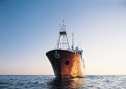
Ship
Since the end of the age of sail a ship has been any large buoyant marine vessel. Ships are generally distinguished from boats based on size and cargo or passenger capacity. Ships are used on lakes, seas, and rivers for a variety of activities, such as the transport of people or goods, fishing,...
stationed in the ocean
Ocean
An ocean is a major body of saline water, and a principal component of the hydrosphere. Approximately 71% of the Earth's surface is covered by ocean, a continuous body of water that is customarily divided into several principal oceans and smaller seas.More than half of this area is over 3,000...
as a platform for surface and upper air meteorological observations for use in weather forecasting
Weather forecasting
Weather forecasting is the application of science and technology to predict the state of the atmosphere for a given location. Human beings have attempted to predict the weather informally for millennia, and formally since the nineteenth century...
. They were primarily located in the north Atlantic
Atlantic Ocean
The Atlantic Ocean is the second-largest of the world's oceanic divisions. With a total area of about , it covers approximately 20% of the Earth's surface and about 26% of its water surface area...
and north Pacific ocean
Pacific Ocean
The Pacific Ocean is the largest of the Earth's oceanic divisions. It extends from the Arctic in the north to the Southern Ocean in the south, bounded by Asia and Australia in the west, and the Americas in the east.At 165.2 million square kilometres in area, this largest division of the World...
s, reporting via radio
Radio
Radio is the transmission of signals through free space by modulation of electromagnetic waves with frequencies below those of visible light. Electromagnetic radiation travels by means of oscillating electromagnetic fields that pass through the air and the vacuum of space...
. In addition to their weather
Weather
Weather is the state of the atmosphere, to the degree that it is hot or cold, wet or dry, calm or stormy, clear or cloudy. Most weather phenomena occur in the troposphere, just below the stratosphere. Weather refers, generally, to day-to-day temperature and precipitation activity, whereas climate...
reporting function, these vessels aided in search and rescue
Search and rescue
Search and rescue is the search for and provision of aid to people who are in distress or imminent danger.The general field of search and rescue includes many specialty sub-fields, mostly based upon terrain considerations...
operations, supported transatlantic flight
Transatlantic flight
Transatlantic flight is the flight of an aircraft across the Atlantic Ocean. A transatlantic flight may proceed east-to-west, originating in Europe or Africa and terminating in North America or South America, or it may go in the reverse direction, west-to-east...
s, acted as research platforms for oceanographers, monitored marine pollution
Marine pollution
Marine pollution occurs when harmful, or potentially harmful effects, can result from the entry into the ocean of chemicals, particles, industrial, agricultural and residential waste, noise, or the spread of invasive organisms. Most sources of marine pollution are land based...
, and aided weather forecasting
Weather forecasting
Weather forecasting is the application of science and technology to predict the state of the atmosphere for a given location. Human beings have attempted to predict the weather informally for millennia, and formally since the nineteenth century...
both by weather forecasters and within computerized Atmospheric model
Atmospheric model
An atmospheric model is a mathematical model constructed around the full set of primitive dynamical equations which govern atmospheric motions. It can supplement these equations with parameterizations for turbulent diffusion, radiation, moist processes , heat exchange, soil, vegetation, surface...
s.
The idea of a stationary weather ship was proposed as early as 1921 by Météo-France
Météo-France
Météo-France is the French national meteorological service.The organisation was established by decree in June 1993 and is a department of the Ministry of Transportation. It is headquartered in Paris but many domestic operations have been decentralised to Toulouse...
to help support shipping and the coming of transatlantic aviation
Aviation
Aviation is the design, development, production, operation, and use of aircraft, especially heavier-than-air aircraft. Aviation is derived from avis, the Latin word for bird.-History:...
. They were used during World War II
World War II
World War II, or the Second World War , was a global conflict lasting from 1939 to 1945, involving most of the world's nations—including all of the great powers—eventually forming two opposing military alliances: the Allies and the Axis...
but had no means of defense, which led to the loss of several ships and many lives. On the whole, the establishment of weather ships proved to be so useful during World War II for Europe
Europe
Europe is, by convention, one of the world's seven continents. Comprising the westernmost peninsula of Eurasia, Europe is generally 'divided' from Asia to its east by the watershed divides of the Ural and Caucasus Mountains, the Ural River, the Caspian and Black Seas, and the waterways connecting...
and North America
North America
North America is a continent wholly within the Northern Hemisphere and almost wholly within the Western Hemisphere. It is also considered a northern subcontinent of the Americas...
that the International Civil Aviation Organization
International Civil Aviation Organization
The International Civil Aviation Organization , pronounced , , is a specialized agency of the United Nations. It codifies the principles and techniques of international air navigation and fosters the planning and development of international air transport to ensure safe and orderly growth...
(ICAO) established a global network of weather ships in 1948, with 13 to be supplied by Canada
Canada
Canada is a North American country consisting of ten provinces and three territories. Located in the northern part of the continent, it extends from the Atlantic Ocean in the east to the Pacific Ocean in the west, and northward into the Arctic Ocean...
, the United States
United States
The United States of America is a federal constitutional republic comprising fifty states and a federal district...
, and Europe. This number was eventually negotiated down to nine. The agreement of the use of weather ships by the international community ended in 1985.
Weather ship observations proved to be helpful in wind and wave studies, as commercial shipping tended to avoid weather systems for safety reasons, whereas the weather ships did not. They were also helpful in monitoring storms at sea, such as tropical cyclone
Tropical cyclone
A tropical cyclone is a storm system characterized by a large low-pressure center and numerous thunderstorms that produce strong winds and heavy rain. Tropical cyclones strengthen when water evaporated from the ocean is released as the saturated air rises, resulting in condensation of water vapor...
s. Beginning in the 1970s, their role was largely superseded by weather buoy
Weather buoy
Weather buoys are instruments which collect weather and ocean data within the world's oceans, as well as aiding during emergency response to chemical spills, legal proceedings, and engineering design. Moored buoys have been in used since 1951, while drifting buoys have been used since 1979...
s because of the ships' significant cost. The removal of a weather ship became a negative factor in forecasts leading up to the Great Storm of 1987
Great Storm of 1987
The Great Storm of 1987 occurred on the night of 15/16 October 1987, when an unusually strong weather system caused winds to hit much of southern England and northern France...
. The last weather ship was Polarfront, known as weather station M ("Mike"), which was removed from operation on January 1, 2010. Weather observations from ships continue from a fleet of voluntary merchant vessels
Voluntary observing ship program
Due to the importance of surface weather observations from the surface of the ocean, the voluntary observing ship program, known as VOS, was set up to train crews how to take weather observations while at sea and also to calibrate weather sensors used aboard ships when they arrive in port, such as...
in routine commercial operation.
Function
The primary purpose of an ocean weather vessel was to take surface and upper air weather measurements, and report them via radio at the synoptic hours of 0000, 0600, 1200, and 1800 Universal Coordinated Time (UTC). Weather ships also reported observations from merchant vessels, which were reported by radio back to their country of origin using a code based on the 16 kilometres (9.9 mi) square in the ocean within which the ship was located. The vessels were involved in search and rescue operations involving aircraft and other ships. The vessels themselves had search radarRadar
Radar is an object-detection system which uses radio waves to determine the range, altitude, direction, or speed of objects. It can be used to detect aircraft, ships, spacecraft, guided missiles, motor vehicles, weather formations, and terrain. The radar dish or antenna transmits pulses of radio...
and could activate a homing beacon
Homing beacon
A homing beacon is a radio or acoustic device that allows the user to track a ship, aircraft, an animal, or another individual. Depending on the beacon, the range can be as short as a hundred metres, or, in science fiction, allow for tracking a ship through hyperspace....
to guide lost aircraft towards the ships' known locations. Each ship's homing beacon used a distinctly different frequency. In addition, the ships provided a platform where scientific and oceanographic research could be conducted. The role of aircraft support gradually changed after 1975, as jet aircraft
Jet aircraft
A jet aircraft is an aircraft propelled by jet engines. Jet aircraft generally fly much faster than propeller-powered aircraft and at higher altitudes – as high as . At these altitudes, jet engines achieve maximum efficiency over long distances. The engines in propeller-powered aircraft...
began using cross polar routes. By 1982, the ocean weather vessel role had changed too, and the ships were used to support short range weather forecasting, in numerical weather prediction
Numerical weather prediction
Numerical weather prediction uses mathematical models of the atmosphere and oceans to predict the weather based on current weather conditions. Though first attempted in the 1920s, it was not until the advent of computer simulation in the 1950s that numerical weather predictions produced realistic...
computer programs which forecast weather conditions several days ahead, for climatological
Climatology
Climatology is the study of climate, scientifically defined as weather conditions averaged over a period of time, and is a branch of the atmospheric sciences...
studies, marine forecasting, and oceanography, as well as monitoring pollution out at sea. At the same time, the transmission of the weather data using Morse code
Morse code
Morse code is a method of transmitting textual information as a series of on-off tones, lights, or clicks that can be directly understood by a skilled listener or observer without special equipment...
was replaced by a system using telex
Telex
Telex may refer to:* Telex , , a communications network** Teleprinter, the device used on the above network* Telex , a Belgian pop group...
-over-radio.
Origin
| Letter | Name | Latitude (North) |
Longitude (East) |
|---|---|---|---|
| A | Able/Alpha | 62° | -33° |
| B | Baker/Bravo | 56° 30" | -51° |
| C | Charlie | 52° 45" | -35° 30" |
| D | Dog/Delta | 44° | -41° |
| E | Easy/Echo | 35° | -48° |
| F | Fox | 35° | -40° |
| G | George | 46° | -29° |
| H | Hotel | 38° | -71° |
| I | India | 59° | -19° |
| J | Juliet/Juliett | 52° 30" | -20° |
| K | Kilo | 45° | -16° |
| L | Lima | 57° | -20° |
| M | Mike | 66° | 2° |
| N | Nan/November | 30° | -140° |
| O | Oboe | 40° | -142° |
| P | Peter/Papa | 50° | -145° |
| Q | Quebec | 43° | -167° |
| R | Romeo | 47° | -17° |
| S | Sugar | 48° | -162° |
| T | Tango | 29° | -135° |
| U | Uncle | 27° 40" | -145° |
| V | Victor | 34° | 164° |
| X | Extra | 39° | 153° |
The director of France
France
The French Republic , The French Republic , The French Republic , (commonly known as France , is a unitary semi-presidential republic in Western Europe with several overseas territories and islands located on other continents and in the Indian, Pacific, and Atlantic oceans. Metropolitan France...
's meteorological service, Météo-France, proposed the idea of a stationary weather ship in 1921 in order to aid shipping and the coming of transatlantic flights. Another early proposal for weather ships occurred in connection with aviation in August 1927, when the aircraft designer Grover Loening
Grover Loening
Grover Cleveland Loening was an American aircraft manufacturer.-Biography:Loening was born in Bremen, Germany, while his American-born father was stationed there as U.S. Consul. He graduated from Columbia University in New York City, where he was awarded the first-ever degree in Aeronautical...
stated that "weather stations along the ocean coupled with the development of the seaplane
Seaplane
A seaplane is a fixed-wing aircraft capable of taking off and landing on water. Seaplanes that can also take off and land on airfields are a subclass called amphibian aircraft...
to have an equally long range, would result in regular ocean flights within ten years." During 1936 and 1937, the British Meteorological Office
Met Office
The Met Office , is the United Kingdom's national weather service, and a trading fund of the Department for Business, Innovation and Skills...
(Met Office) installed a meteorologist aboard a North Atlantic cargo steamer
Steamboat
A steamboat or steamship, sometimes called a steamer, is a ship in which the primary method of propulsion is steam power, typically driving propellers or paddlewheels...
to take special surface weather observation
Surface weather observation
Surface weather observations are the fundamental data used for safety as well as climatological reasons to forecast weather and issue warnings worldwide. They can be taken manually, by a weather observer, by computer through the use of automated weather stations, or in a hybrid scheme using...
s and release pilot balloons
Ceiling balloon
A ceiling balloon is used by meteorologists to determine the height of the base of clouds above ground level during daylight hours.The principle behind the ceiling balloon is a balloon with a known ascent rate and determining how long the balloon rises until it disappears into the cloud.Ascent...
to measure the winds aloft at the synoptic hours of 0000, 0600, 1200, and 1800 UTC. In 1938 and 1939, France established a merchant ship as the first stationary weather ship, which took surface observations and launched radiosonde
Radiosonde
A radiosonde is a unit for use in weather balloons that measures various atmospheric parameters and transmits them to a fixed receiver. Radiosondes may operate at a radio frequency of 403 MHz or 1680 MHz and both types may be adjusted slightly higher or lower as required...
s to measure weather conditions aloft.
Starting in 1939, United States Coast Guard
United States Coast Guard
The United States Coast Guard is a branch of the United States Armed Forces and one of the seven U.S. uniformed services. The Coast Guard is a maritime, military, multi-mission service unique among the military branches for having a maritime law enforcement mission and a federal regulatory agency...
vessels were being used as weather ships to protect transatlantic air commerce, as a response to the crash of a Pan American World Airways
Pan American World Airways
Pan American World Airways, commonly known as Pan Am, was the principal and largest international air carrier in the United States from 1927 until its collapse on December 4, 1991...
aircraft during a transpacific flight in 1938. The Atlantic Weather Observation Service was authorized by President Franklin Delano Roosevelt on January 25, 1940. The Germans
Nazi Germany
Nazi Germany , also known as the Third Reich , but officially called German Reich from 1933 to 1943 and Greater German Reich from 26 June 1943 onward, is the name commonly used to refer to the state of Germany from 1933 to 1945, when it was a totalitarian dictatorship ruled by...
began to use weather ships in the summer of 1940. However, three of their four ships had been sunk by November 23, which led to the use of fishing vessels for the German weather ship fleet. Their weather ships were out to sea for three to five weeks at a time and German weather observations were encipher
Cipher
In cryptography, a cipher is an algorithm for performing encryption or decryption — a series of well-defined steps that can be followed as a procedure. An alternative, less common term is encipherment. In non-technical usage, a “cipher” is the same thing as a “code”; however, the concepts...
ed using Enigma machine
Enigma machine
An Enigma machine is any of a family of related electro-mechanical rotor cipher machines used for the encryption and decryption of secret messages. Enigma was invented by German engineer Arthur Scherbius at the end of World War I...
s. By February 1941, five 327 feet (99.7 m) United States Coast Guard cutters were used in weather patrol, usually deployed for three weeks at a time, then sent back to port for ten days. As World War II continued, the cutters were needed for the war effort and by August 1942, six cargo vessels
Cargo ship
A cargo ship or freighter is any sort of ship or vessel that carries cargo, goods, and materials from one port to another. Thousands of cargo carriers ply the world's seas and oceans each year; they handle the bulk of international trade...
had replaced them. The ships were defenseless, which led to the loss of the USCGC Muskeget (WAG-48)
USS Muskeget (AG-48)
USS Muskeget – later known as USCGC Muskeget – was a commercial cargo ship acquired by the U.S. Navy during World War II. She was outfitted with a variety of guns and depth charge devices and sent on weather patrol in the North Atlantic Ocean...
with 121 aboard on September 9, 1942. In 1943, the United States Weather Bureau recognized their observations as "indispensable" during the war effort.
The flying of fighter planes between North America
North America
North America is a continent wholly within the Northern Hemisphere and almost wholly within the Western Hemisphere. It is also considered a northern subcontinent of the Americas...
, Greenland
Greenland
Greenland is an autonomous country within the Kingdom of Denmark, located between the Arctic and Atlantic Oceans, east of the Canadian Arctic Archipelago. Though physiographically a part of the continent of North America, Greenland has been politically and culturally associated with Europe for...
, and Iceland
Iceland
Iceland , described as the Republic of Iceland, is a Nordic and European island country in the North Atlantic Ocean, on the Mid-Atlantic Ridge. Iceland also refers to the main island of the country, which contains almost all the population and almost all the land area. The country has a population...
led to the deployment of two more weather ships in 1943 and 1944. Great Britain
Great Britain
Great Britain or Britain is an island situated to the northwest of Continental Europe. It is the ninth largest island in the world, and the largest European island, as well as the largest of the British Isles...
established one of their own 80 kilometres (49.7 mi) off their west coast. By May 1945, frigates were used across the Pacific for similar operations. Weather Bureau personnel stationed on weather ships were asked voluntarily to accept the assignment. In addition to surface weather observations, the weather ships would launch radiosondes and release pilot balloons, or PIBALs, to determine weather conditions aloft. However, after the war ended, the ships were withdrawn from service, which led to a loss of upper air weather observations over the oceans. Due to its value, operations resumed after World War II as a result of an international agreement made in September 1946, which stated that no fewer than 13 ocean weather stations would be maintained by the Coast Guard, with five others maintained by Great Britain and two by Brazil
Brazil
Brazil , officially the Federative Republic of Brazil , is the largest country in South America. It is the world's fifth largest country, both by geographical area and by population with over 192 million people...
.
Late 1940s
The establishment of weather ships proved to be so useful during World War II that the International Civil Aviation OrganizationInternational Civil Aviation Organization
The International Civil Aviation Organization , pronounced , , is a specialized agency of the United Nations. It codifies the principles and techniques of international air navigation and fosters the planning and development of international air transport to ensure safe and orderly growth...
(ICAO) had established a global network of 13 weather ships by 1948, with seven operated by the United States, one operated jointly by the United States and Canada, two supplied by the United Kingdom, one maintained by France, one a joint venture by the Netherlands
Netherlands
The Netherlands is a constituent country of the Kingdom of the Netherlands, located mainly in North-West Europe and with several islands in the Caribbean. Mainland Netherlands borders the North Sea to the north and west, Belgium to the south, and Germany to the east, and shares maritime borders...
and Belgium
Belgium
Belgium , officially the Kingdom of Belgium, is a federal state in Western Europe. It is a founding member of the European Union and hosts the EU's headquarters, and those of several other major international organisations such as NATO.Belgium is also a member of, or affiliated to, many...
, and one shared by the United Kingdom, Norway
Norway
Norway , officially the Kingdom of Norway, is a Nordic unitary constitutional monarchy whose territory comprises the western portion of the Scandinavian Peninsula, Jan Mayen, and the Arctic archipelago of Svalbard and Bouvet Island. Norway has a total area of and a population of about 4.9 million...
, and Sweden
Sweden
Sweden , officially the Kingdom of Sweden , is a Nordic country on the Scandinavian Peninsula in Northern Europe. Sweden borders with Norway and Finland and is connected to Denmark by a bridge-tunnel across the Öresund....
. The United Kingdom used Royal Navy
Royal Navy
The Royal Navy is the naval warfare service branch of the British Armed Forces. Founded in the 16th century, it is the oldest service branch and is known as the Senior Service...
corvette
Corvette
A corvette is a small, maneuverable, lightly armed warship, originally smaller than a frigate and larger than a coastal patrol craft or fast attack craft , although many recent designs resemble frigates in size and role...
s to operate their two stations, and staffed crews of 53 Met Office personnel. The ships were out at sea for 27 days, and in port
Port
A port is a location on a coast or shore containing one or more harbors where ships can dock and transfer people or cargo to or from land....
for 15 days. Their first ship was deployed on July 31, 1947.
During 1949, the Weather Bureau planned to increase the number of United States Coast Guard weather ships in the Atlantic from five at the beginning of the year to eight by its end. Weather Bureau employees aboard the vessels worked 40 to 63 hours per week. Weather ship G ("George") was dropped from the network on July 1, 1949, and Navy weather ship "Bird Dog" ceased operations on August 1, 1949. In the Atlantic, weather vessel F ("Fox") was discontinued on September 3, 1949, and there was a change in location for ships D ("Dog") and E ("Easy") at the same time. Navy weather ship J ("Jig") in the north-central Pacific ocean was placed out of service on October 1, 1949. The original international agreement for a 13 ship minimum was later amended downward. In 1949, the minimum number of weather ships operated by the United States was decreased to ten, and in 1954 the figure was lowered again to nine, both changes being made for economic reasons. Weather vessel O ("Oboe") entered the Pacific portion of the network on December 19, 1949. Also in the Pacific, weather ship A ("Able") was renamed ship P ("Peter") and moved 200 miles (321.9 km) to the east-northeast in December 1949, while weather vessel F ("Fox") was renamed N ("Nan").
1950s
Weather ship B ("Baker"), which had been jointly operated by Canada and the United States, became solely a United States venture on July 1, 1950. The Netherlands and the United States began to jointly operate weather ship A ("Able") in the Atlantic on July 22, 1950. The Korean WarKorean War
The Korean War was a conventional war between South Korea, supported by the United Nations, and North Korea, supported by the People's Republic of China , with military material aid from the Soviet Union...
led to the discontinuing of weather vessel O ("Oboe") on July 31, 1950 in the Pacific, and ship S ("Sugar") was established on September 10, 1950. Weather ship P's ("Peter") operations were taken over by Canada on December 1, 1950, which allowed the Coast Guard to begin operating station U ("Uncle") 2000 kilometres (1,242.7 mi) west of northern Baja California
Baja California
Baja California officially Estado Libre y Soberano de Baja California is one of the 31 states which, with the Federal District, comprise the 32 Federal Entities of Mexico. It is both the northernmost and westernmost state of Mexico. Before becoming a state in 1953, the area was known as the North...
on December 12, 1950. As a result of these changes, ship N ("Nan") was moved 400 kilometres (248.5 mi) to the southeast on December 10, 1950.
Responsibility for weather ship V ("Victor") transferred from the United States Navy to the United States Coast Guard and Weather Bureau on September 30, 1951. On March 20, 1952, Vessels N ("November") and U ("Uncle") were moved 32 kilometres (19.9 mi) to 48 kilometres (29.8 mi) to the south to lie under airplane paths between the western United States coast and Honolulu, Hawaii
Hawaii
Hawaii is the newest of the 50 U.S. states , and is the only U.S. state made up entirely of islands. It is the northernmost island group in Polynesia, occupying most of an archipelago in the central Pacific Ocean, southwest of the continental United States, southeast of Japan, and northeast of...
. Weather vessel Q ("Quebec") began operation in the north-central Pacific on April 6, 1952, while in the western Atlantic, the British corvettes used as weather ships were replaced by newer Castle-class frigate
Frigate
A frigate is any of several types of warship, the term having been used for ships of various sizes and roles over the last few centuries.In the 17th century, the term was used for any warship built for speed and maneuverability, the description often used being "frigate-built"...
s between 1958 and 1961.
1960s
In 1963, the entire fleet won the Flight Safety FoundationFlight Safety Foundation
Flight Safety Foundation is an independent, nonprofit, international organization dedicated to research, education, advocacy and publishing in the field of air safety. FSF brings together aviation professionals from all the sectors to help solve safety problems facing the industry...
award for their distinguished service to aviation
Aviation
Aviation is the design, development, production, operation, and use of aircraft, especially heavier-than-air aircraft. Aviation is derived from avis, the Latin word for bird.-History:...
. In 1965, there were a total of 21 vessels in the weather ship network. Nine were from the United States, four from the United Kingdom, three from France
France
The French Republic , The French Republic , The French Republic , (commonly known as France , is a unitary semi-presidential republic in Western Europe with several overseas territories and islands located on other continents and in the Indian, Pacific, and Atlantic oceans. Metropolitan France...
, two from the Netherlands
Netherlands
The Netherlands is a constituent country of the Kingdom of the Netherlands, located mainly in North-West Europe and with several islands in the Caribbean. Mainland Netherlands borders the North Sea to the north and west, Belgium to the south, and Germany to the east, and shares maritime borders...
, two from Norway
Norway
Norway , officially the Kingdom of Norway, is a Nordic unitary constitutional monarchy whose territory comprises the western portion of the Scandinavian Peninsula, Jan Mayen, and the Arctic archipelago of Svalbard and Bouvet Island. Norway has a total area of and a population of about 4.9 million...
, and one from Canada
Canada
Canada is a North American country consisting of ten provinces and three territories. Located in the northern part of the continent, it extends from the Atlantic Ocean in the east to the Pacific Ocean in the west, and northward into the Arctic Ocean...
. In addition to the routine hourly weather observations and upper air flights four times a day, two Russian
Soviet Union
The Soviet Union , officially the Union of Soviet Socialist Republics , was a constitutionally socialist state that existed in Eurasia between 1922 and 1991....
ships in the northern and central Pacific ocean sent meteorological rockets
Sounding rocket
A sounding rocket, sometimes called a research rocket, is an instrument-carrying rocket designed to take measurements and perform scientific experiments during its sub-orbital flight. The origin of the term comes from nautical vocabulary, where to sound is to throw a weighted line from a ship into...
up to a height of 80 kilometres (49.7 mi). For a time, there was a Dutch weather ship stationed in the Indian Ocean
Indian Ocean
The Indian Ocean is the third largest of the world's oceanic divisions, covering approximately 20% of the water on the Earth's surface. It is bounded on the north by the Indian Subcontinent and Arabian Peninsula ; on the west by eastern Africa; on the east by Indochina, the Sunda Islands, and...
. The network left the Southern Hemisphere
Southern Hemisphere
The Southern Hemisphere is the part of Earth that lies south of the equator. The word hemisphere literally means 'half ball' or "half sphere"...
mainly uncovered. South Africa
South Africa
The Republic of South Africa is a country in southern Africa. Located at the southern tip of Africa, it is divided into nine provinces, with of coastline on the Atlantic and Indian oceans...
maintained a weather ship near latitude 40° South
40th parallel south
The 40th parallel south is a circle of latitude that is 40 degrees south of the Earth's equatorial plane. It crosses the Atlantic Ocean, the Indian Ocean, Australasia, the Pacific Ocean and South America....
, longitude 10° East
10th meridian east
The meridian 10° east of Greenwich is a line of longitude that extends from the North Pole across the Arctic Ocean, Europe, Africa, the Atlantic Ocean, the Southern Ocean, and Antarctica to the South Pole....
between September 1969 and March 1974.
Fading use
A new international agreement for ocean weather vessels was reached through the World Meteorological Organization
World Meteorological Organization
The World Meteorological Organization is an intergovernmental organization with a membership of 189 Member States and Territories. It originated from the International Meteorological Organization , which was founded in 1873...
in 1975, which eliminated Ships I (India) and J (Juliett), and left ships M ("Mike"), R ("Romeo"), C ("Charlie"), and L ("Lima") across the northern Atlantic, with the four remaining ships in operation through 1983. Two of the British frigates were refurbished, as there was no funding available for new weather ships. Their other two ships were retired, as one of the British run stations was eliminated in the international agreement. In July 1975, the Soviet Union
Soviet Union
The Soviet Union , officially the Union of Soviet Socialist Republics , was a constitutionally socialist state that existed in Eurasia between 1922 and 1991....
began to maintain weather ship C ("Charlie"), which it would operate through the remainder of the 1970s and 1980s. The last two British frigates were retired from ocean weather service by January 11, 1982, but the international agreement for weather ships was continued through 1985.
Because of high operating cost
Operating cost
Operating costs can be described as the expenses which are related to the operation of a business, or to the operation of a device, component, piece of equipment or facility.-Business operating costs:...
s and budget issues, weather ship R ("Romeo") was recalled from the Bay of Biscay
Bay of Biscay
The Bay of Biscay is a gulf of the northeast Atlantic Ocean located south of the Celtic Sea. It lies along the western coast of France from Brest south to the Spanish border, and the northern coast of Spain west to Cape Ortegal, and is named in English after the province of Biscay, in the Spanish...
before the deployment of a weather buoy for the region. This recall was blamed for the minimal warning given in advance of the Great Storm of 1987, when wind speeds of up to 149 kph caused extensive damage to areas of southern England and northern France
France
The French Republic , The French Republic , The French Republic , (commonly known as France , is a unitary semi-presidential republic in Western Europe with several overseas territories and islands located on other continents and in the Indian, Pacific, and Atlantic oceans. Metropolitan France...
. The last weather ship was Polarfront, known as weather station M ("Mike") at 66°N, 02°E, run by the Norwegian Meteorological Institute
Norwegian Meteorological Institute
Norwegian Meteorological Institute is the Norwegian national institute for weather forecasts.The three main offices are located in Oslo, Bergen and Tromsø. The Institute has around 500 employees and keeps around 650 paid observers of various kinds around the country...
. Polarfront was withdrawn operation on January 1, 2010. Despite the loss of designated weather ships, weather observations from ships continue from a fleet of voluntary merchant vessels in routine commercial operation, whose number has decreased since 1985.
Use in research
Beginning in 1951, British ocean weather vessels began oceanographic research, such as monitoring planktonPlankton
Plankton are any drifting organisms that inhabit the pelagic zone of oceans, seas, or bodies of fresh water. That is, plankton are defined by their ecological niche rather than phylogenetic or taxonomic classification...
, casting of drift bottles, and sampling seawater
Seawater
Seawater is water from a sea or ocean. On average, seawater in the world's oceans has a salinity of about 3.5% . This means that every kilogram of seawater has approximately of dissolved salts . The average density of seawater at the ocean surface is 1.025 g/ml...
. In July of 1952, as part of a research project on birds by Cambridge University, twenty shearwater
Shearwater
Shearwaters are medium-sized long-winged seabirds. There are more than 30 species of shearwaters, a few larger ones in the genus Calonectris and many smaller species in the genus Puffinus...
s were taken more than 161 kilometres (100 mi) offshore in British weather ships, before being released to see how quickly they would return back to their nests, which were more than 720 kilometres (447.4 mi) away on Skokholm
Skokholm
Skokholm is an uninhabited island off the coast of south west Pembrokeshire in Wales, lying south of the neighbouring island of Skomer. The whole island is a Site of Special Scientific Interest as is Skomer. The surrounding waters are a marine reserve, all part of the Pembrokeshire Coast National...
Island. 18 of the twenty returned, the first in just 36 hours. During 1954, British weather ocean vessels began to measure sea surface temperature
Sea surface temperature
Sea surface temperature is the water temperature close to the oceans surface. The exact meaning of surface varies according to the measurement method used, but it is between and below the sea surface. Air masses in the Earth's atmosphere are highly modified by sea surface temperatures within a...
gradients and monitored ocean waves. In 1960, weather ships proved to be helpful in ship design
Naval architecture
Naval architecture is an engineering discipline dealing with the design, construction, maintenance and operation of marine vessels and structures. Naval architecture involves basic and applied research, design, development, design evaluation and calculations during all stages of the life of a...
through a series of recordings made on paper tape
Punched tape
Punched tape or paper tape is an obsolete form of data storage, consisting of a long strip of paper in which holes are punched to store data...
which evaluated wave height, pitch, and roll. They were also useful in wind and wave studies, as they did not avoid weather systems like merchant ships tended to and were considered a valuable resource.
In 1962, British weather vessels measured sea temperature and salinity values from the surface down to 3000 metres (9,842.5 ft) as part of their duties. Upper air soundings launched from weather ship E ("Echo") were of great utility in determining the cyclone phase of Hurricane Dorothy in 1966. During 1971, British weather ships sampled the upper 500 metres (1,640.4 ft) of the ocean to investigate plankton distribution by depth. In 1972, the Joint Air-Sea Interaction Experiment (JASIN) utilized special observations from weather ships for their research. More recently, in support of climate research, 20 years of data from the ocean vessel P ("Papa") was compared to nearby voluntary weather observations from mobile ships within the International Comprehensive Ocean-Atmosphere Data Set
International Comprehensive Ocean-Atmosphere Data Set
The International Comprehensive Ocean-Atmosphere Data Set, or ICOADS, is a digital database of 261 million weather observations made by ships, weather ships, and weather buoys spanning the years 1667 to 2007. The database was initially constructed in 1985 and continues to be expanded upon and...
to check for biases in mobile ship observations over that time frame.
See also
- Bermuda Atlantic Time-series StudyBermuda Atlantic Time-series StudyThe Bermuda Atlantic Time-series Study is a long-term oceanographic study by the Bermuda Institute of Ocean Sciences . Based on regular research cruises, it samples an area of the western Atlantic Ocean nominally at the coordinates...
(BATS) - Hawaii Ocean Time-seriesHawaii Ocean Time-seriesThe Hawaii Ocean Time-series program is a long-term oceanographic study based at the University of Hawaii at Manoa.Scientists working on the Hawaii Ocean Time-series program have been making repeated observations of the hydrography, chemistry and biology of the water column at a station north of...
(HOT) - Weather stationWeather stationA weather station is a facility, either on land or sea, with instruments and equipment for observing atmospheric conditions to provide information for weather forecasts and to study the weather and climate. The measurements taken include temperature, barometric pressure, humidity, wind speed, wind...
External links
Books
- OCEAN STATION: Operations of the U.S. Coast Guard, 1940-1977 (Michael R. Adams, Nor'easter Press, 2010), ISBN 978-0-9779200-1-3. A history of the weather ships and the ocean station patrols.