

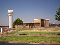
Weather station
Encyclopedia
Earth's atmosphere
The atmosphere of Earth is a layer of gases surrounding the planet Earth that is retained by Earth's gravity. The atmosphere protects life on Earth by absorbing ultraviolet solar radiation, warming the surface through heat retention , and reducing temperature extremes between day and night...
conditions to provide information for weather forecasts
Weather forecasting
Weather forecasting is the application of science and technology to predict the state of the atmosphere for a given location. Human beings have attempted to predict the weather informally for millennia, and formally since the nineteenth century...
and to study the weather
Weather
Weather is the state of the atmosphere, to the degree that it is hot or cold, wet or dry, calm or stormy, clear or cloudy. Most weather phenomena occur in the troposphere, just below the stratosphere. Weather refers, generally, to day-to-day temperature and precipitation activity, whereas climate...
and climate
Climate
Climate encompasses the statistics of temperature, humidity, atmospheric pressure, wind, rainfall, atmospheric particle count and other meteorological elemental measurements in a given region over long periods...
. The measurements taken include temperature
Temperature
Temperature is a physical property of matter that quantitatively expresses the common notions of hot and cold. Objects of low temperature are cold, while various degrees of higher temperatures are referred to as warm or hot...
, barometric pressure, humidity
Humidity
Humidity is a term for the amount of water vapor in the air, and can refer to any one of several measurements of humidity. Formally, humid air is not "moist air" but a mixture of water vapor and other constituents of air, and humidity is defined in terms of the water content of this mixture,...
, wind speed
Wind speed
Wind speed, or wind velocity, is a fundamental atmospheric rate.Wind speed affects weather forecasting, aircraft and maritime operations, construction projects, growth and metabolism rate of many plant species, and countless other implications....
, wind direction
Wind direction
Wind direction is reported by the direction from which it originates. For example, a northerly wind blows from the north to the south. Wind direction is usually reported in cardinal directions or in azimuth degrees...
, and precipitation
Precipitation (meteorology)
In meteorology, precipitation In meteorology, precipitation In meteorology, precipitation (also known as one of the classes of hydrometeors, which are atmospheric water phenomena is any product of the condensation of atmospheric water vapor that falls under gravity. The main forms of precipitation...
amounts. Wind measurements are taken as free of other obstructions as possible, while temperature and humidity measurements are kept free from direct solar radiation, or insolation
Insolation
Insolation is a measure of solar radiation energy received on a given surface area in a given time. It is commonly expressed as average irradiance in watts per square meter or kilowatt-hours per square meter per day...
. Manual observations are taken at least once daily, while automated observations are taken at least once an hour. Weather conditions out at sea are taken by ships and buoys, which measure slightly different meteorological quantities such as sea surface temperature
Sea surface temperature
Sea surface temperature is the water temperature close to the oceans surface. The exact meaning of surface varies according to the measurement method used, but it is between and below the sea surface. Air masses in the Earth's atmosphere are highly modified by sea surface temperatures within a...
, wave height, and wave period. Drifting weather buoy
Weather buoy
Weather buoys are instruments which collect weather and ocean data within the world's oceans, as well as aiding during emergency response to chemical spills, legal proceedings, and engineering design. Moored buoys have been in used since 1951, while drifting buoys have been used since 1979...
s outnumber their moored versions by a significant amount.
Instruments
Typical weather stations have the following instruments:- ThermometerThermometerDeveloped during the 16th and 17th centuries, a thermometer is a device that measures temperature or temperature gradient using a variety of different principles. A thermometer has two important elements: the temperature sensor Developed during the 16th and 17th centuries, a thermometer (from the...
for measuring air and sea surface temperature - BarometerBarometerA barometer is a scientific instrument used in meteorology to measure atmospheric pressure. Pressure tendency can forecast short term changes in the weather...
for measuring atmospheric pressureAtmospheric pressureAtmospheric pressure is the force per unit area exerted into a surface by the weight of air above that surface in the atmosphere of Earth . In most circumstances atmospheric pressure is closely approximated by the hydrostatic pressure caused by the weight of air above the measurement point... - HygrometerHygrometerA hygrometer is an instrument used for measuring the moisture content in the environmental air, or humidity. Most measurement devices usually rely on measurements of some other quantity such as temperature, pressure, mass or a mechanical or electrical change in a substance as moisture is absorbed...
for measuring humidity. - AnemometerAnemometerAn anemometer is a device for measuring wind speed, and is a common weather station instrument. The term is derived from the Greek word anemos, meaning wind, and is used to describe any airspeed measurement instrument used in meteorology or aerodynamics...
for measuring wind speedWind speedWind speed, or wind velocity, is a fundamental atmospheric rate.Wind speed affects weather forecasting, aircraft and maritime operations, construction projects, growth and metabolism rate of many plant species, and countless other implications.... - Rain gaugeRain gaugeA rain gauge is a type of instrument used by meteorologists and hydrologists to gather and measure the amount of liquid precipitation over a set period of time....
for measuring liquid precipitation over a set period of time.
In addition, at certain Automated airport weather station
Automated airport weather station
Automated airport weather stations are automated sensor suites which are designed to serve aviation and meteorological observing needs for safe and efficient aviation operations and weather forecasting...
s, additional instruments may be employed, including:
- Present Weather/Precipitation Identification Sensor for identifying falling precipitation
- DisdrometerDisdrometerA disdrometer is an instrument used to measure the drop size distribution and velocity of falling hydrometeors. Some disdrometers can distinguish between rain, graupel, and hail....
for measuring drop size distribution - TransmissometerTransmissometerA transmissometer is an instrument for measuring the extinction coefficient of the atmosphere, and for the determination of visual range. It operates by sending a narrow, collimated beam of energy through the propagation medium...
for measuring visibility - Ceiling projectorCeiling projectorThe ceiling projector or cloud searchlight is used to measure the height of the base of clouds above the ground. It is used in conjunction with an alidade, usually positioned 1000 ft away and wherever possible set at the same level.The projector is normally set at 90°, although 71° 31' may be...
for measuring cloud ceiling
More sophisticated stations may also measure the ultraviolet index, solar radiation, leaf wetness
Leaf wetness
Leaf wetness is an meteorological parameter that describes the amount of dew and precipitation left on surfaces. It is used for monitoring leaf moisture for agricultural purposes, such as fungus and disease control, for control of irrigation systems, and for detection of fog and dew conditions, and...
, soil moisture, soil temperature, water temperature in ponds, lakes, creeks, or rivers, and occasionally other data.
Exposure
Except for those instruments requiring direct exposure to the elements (anemometerAnemometer
An anemometer is a device for measuring wind speed, and is a common weather station instrument. The term is derived from the Greek word anemos, meaning wind, and is used to describe any airspeed measurement instrument used in meteorology or aerodynamics...
, rain gauge
Rain gauge
A rain gauge is a type of instrument used by meteorologists and hydrologists to gather and measure the amount of liquid precipitation over a set period of time....
), the instruments should be sheltered in a vented box, usually a Stevenson screen
Stevenson screen
A Stevenson screen or instrument shelter is an enclosure to shield meteorological instruments against precipitation and direct heat radiation from outside sources, while still allowing air to circulate freely around them. It forms part of a standard weather station...
, to keep direct sunlight off the thermometer
Thermometer
Developed during the 16th and 17th centuries, a thermometer is a device that measures temperature or temperature gradient using a variety of different principles. A thermometer has two important elements: the temperature sensor Developed during the 16th and 17th centuries, a thermometer (from the...
and wind off the hygrometer
Hygrometer
A hygrometer is an instrument used for measuring the moisture content in the environmental air, or humidity. Most measurement devices usually rely on measurements of some other quantity such as temperature, pressure, mass or a mechanical or electrical change in a substance as moisture is absorbed...
. The instrumentation may be specialized to allow for periodic recording otherwise significant manual labour is required for record keeping. Automatic transmission of data, in a format such as METAR
METAR
METAR is a format for reporting weather information. A METAR weather report is predominantly used by pilots in fulfillment of a part of a pre-flight weather briefing, and by meteorologists, who use aggregated METAR information to assist in weather forecasting....
, is also desirable as many weather station's data is required for weather forecasting
Weather forecasting
Weather forecasting is the application of science and technology to predict the state of the atmosphere for a given location. Human beings have attempted to predict the weather informally for millennia, and formally since the nineteenth century...
.
Personal weather station
A personal weather station is a set of weatherWeather
Weather is the state of the atmosphere, to the degree that it is hot or cold, wet or dry, calm or stormy, clear or cloudy. Most weather phenomena occur in the troposphere, just below the stratosphere. Weather refers, generally, to day-to-day temperature and precipitation activity, whereas climate...
measuring instruments operated by a private individual, club, association, or even business (where obtaining and distributing weather data is not a part of the entity's business operation). The quality and number of instruments can vary widely, and placement of the instruments, so important to obtaining accurate, meaningful, and comparable data, can also be very variable.
Today's personal weather stations also typically involve a digital console that provides readouts of the data being collected. These consoles may interface to a personal computer
Personal computer
A personal computer is any general-purpose computer whose size, capabilities, and original sales price make it useful for individuals, and which is intended to be operated directly by an end-user with no intervening computer operator...
where data can be displayed, stored, and uploaded to Web sites or data ingestion/distribution systems.
Personal weather stations may be operated solely for the enjoyment and education of the owner, but many personal weather station operators also share their data with others, either by manually compiling data and distributing it, or through use of the Internet or amateur radio
Amateur radio
Amateur radio is the use of designated radio frequency spectrum for purposes of private recreation, non-commercial exchange of messages, wireless experimentation, self-training, and emergency communication...
. The Citizen Weather Observer Program
Citizen Weather Observer Program
The Citizen Weather Observer Program allows users with computerized weather stations to send their information via a Web site to be included into the United States Mesonet...
(CWOP) is one such, and the data submitted through use of software, a personal computer, and internet connection (or amateur radio) are utilized by the National Weather Service when generating forecast models, and by many other entities as well. Each weather station submitting data to CWOP will also have an individual Web page that depicts the data submitted by that station. The Weather Underground
Weather Underground (weather service)
Weather Underground is a commercial weather service that provides real-time weather information via the Internet. Weather Underground provides weather reports for most major cities across the world on its Web site, as well as local weather reports for newspapers and Web sites...
Internet site is another popular destination for the submittal and sharing of data with others around the world. As with CWOP, each station submitting data to The Weather Underground has a unique Web page displaying their submitted data.
Dedicated ships
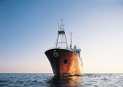
A weather ship
Weather ship
A weather ship was a ship stationed in the ocean as a platform for surface and upper air meteorological observations for use in weather forecasting. They were primarily located in the north Atlantic and north Pacific oceans, reporting via radio...
was a ship
Ship
Since the end of the age of sail a ship has been any large buoyant marine vessel. Ships are generally distinguished from boats based on size and cargo or passenger capacity. Ships are used on lakes, seas, and rivers for a variety of activities, such as the transport of people or goods, fishing,...
stationed in the ocean
Ocean
An ocean is a major body of saline water, and a principal component of the hydrosphere. Approximately 71% of the Earth's surface is covered by ocean, a continuous body of water that is customarily divided into several principal oceans and smaller seas.More than half of this area is over 3,000...
as a platform for surface and upper air meteorological observations for use in weather forecasting
Weather forecasting
Weather forecasting is the application of science and technology to predict the state of the atmosphere for a given location. Human beings have attempted to predict the weather informally for millennia, and formally since the nineteenth century...
. It was also meant to aid in search and rescue operations and to support transatlantic flights. The establishment of weather ships proved to be so useful during World War II
World War II
World War II, or the Second World War , was a global conflict lasting from 1939 to 1945, involving most of the world's nations—including all of the great powers—eventually forming two opposing military alliances: the Allies and the Axis...
that the International Civil Aviation Organization
International Civil Aviation Organization
The International Civil Aviation Organization , pronounced , , is a specialized agency of the United Nations. It codifies the principles and techniques of international air navigation and fosters the planning and development of international air transport to ensure safe and orderly growth...
(ICAO) established a global network of 13 weather ships in 1948. Of the 12 left in operation in 1996, nine were located in the northern Atlantic ocean
Atlantic Ocean
The Atlantic Ocean is the second-largest of the world's oceanic divisions. With a total area of about , it covers approximately 20% of the Earth's surface and about 26% of its water surface area...
while three were located in the northern Pacific ocean
Pacific Ocean
The Pacific Ocean is the largest of the Earth's oceanic divisions. It extends from the Arctic in the north to the Southern Ocean in the south, bounded by Asia and Australia in the west, and the Americas in the east.At 165.2 million square kilometres in area, this largest division of the World...
. The agreement of the weather ships ended in 1990. Weather ship observations proved to be helpful in wind and wave studies, as they did not avoid weather systems like merchant ships tended to and were considered a valuable resource. The last weather ship was MS Polarfront
MS Polarfront
MS Polarfront was a Norwegian weather ship located in the North Atlantic. She was the last remaining weather ship in the world, maintained by the Norwegian Meteorological Institute....
, known as weather station M ("Mike") at 66°N, 02°E, run by the Norwegian Meteorological Institute
Norwegian Meteorological Institute
Norwegian Meteorological Institute is the Norwegian national institute for weather forecasts.The three main offices are located in Oslo, Bergen and Tromsø. The Institute has around 500 employees and keeps around 650 paid observers of various kinds around the country...
. MS Polarfront was removed from service January 1, 2010. Since the 1960s this role has been largely superseded by satellite
Satellite
In the context of spaceflight, a satellite is an object which has been placed into orbit by human endeavour. Such objects are sometimes called artificial satellites to distinguish them from natural satellites such as the Moon....
s, long range aircraft
Aircraft
An aircraft is a vehicle that is able to fly by gaining support from the air, or, in general, the atmosphere of a planet. An aircraft counters the force of gravity by using either static lift or by using the dynamic lift of an airfoil, or in a few cases the downward thrust from jet engines.Although...
and weather buoy
Weather buoy
Weather buoys are instruments which collect weather and ocean data within the world's oceans, as well as aiding during emergency response to chemical spills, legal proceedings, and engineering design. Moored buoys have been in used since 1951, while drifting buoys have been used since 1979...
s. Weather observations from ships continue from a fleet of voluntary merchant vessels in routine commercial operation.
Dedicated buoys

Weather
Weather is the state of the atmosphere, to the degree that it is hot or cold, wet or dry, calm or stormy, clear or cloudy. Most weather phenomena occur in the troposphere, just below the stratosphere. Weather refers, generally, to day-to-day temperature and precipitation activity, whereas climate...
and ocean
Ocean
An ocean is a major body of saline water, and a principal component of the hydrosphere. Approximately 71% of the Earth's surface is covered by ocean, a continuous body of water that is customarily divided into several principal oceans and smaller seas.More than half of this area is over 3,000...
data within the worlds oceans. Moored buoys have been in use since 1951, while drifting buoys have been used since the late 1970s. Moored buoys are connected with the ocean bottom using either chains, nylon
Nylon
Nylon is a generic designation for a family of synthetic polymers known generically as polyamides, first produced on February 28, 1935, by Wallace Carothers at DuPont's research facility at the DuPont Experimental Station...
, or buoyant polypropylene
Polypropylene
Polypropylene , also known as polypropene, is a thermoplastic polymer used in a wide variety of applications including packaging, textiles , stationery, plastic parts and reusable containers of various types, laboratory equipment, loudspeakers, automotive components, and polymer banknotes...
. With the decline of the weather ship
Weather ship
A weather ship was a ship stationed in the ocean as a platform for surface and upper air meteorological observations for use in weather forecasting. They were primarily located in the north Atlantic and north Pacific oceans, reporting via radio...
, they have taken a more primary role in measuring conditions over the open seas since the 1970s. During the 1980s and 1990s, a network of buoys in the central and eastern tropical Pacific ocean helped study the El Niño-Southern Oscillation
El Niño-Southern Oscillation
El Niño/La Niña-Southern Oscillation, or ENSO, is a quasiperiodic climate pattern that occurs across the tropical Pacific Ocean roughly every five years...
. Moored weather buoys range from 1.5 metres (4.9 ft) to 12 metres (39.4 ft) in diameter, while drifting buoys are smaller, with diameters of 30 centimetres (11.8 in) to 40 centimetres (15.7 in). Drifting buoys are the dominant form of weather buoy in sheer number, with 1250 located worldwide. Wind
Wind
Wind is the flow of gases on a large scale. On Earth, wind consists of the bulk movement of air. In outer space, solar wind is the movement of gases or charged particles from the sun through space, while planetary wind is the outgassing of light chemical elements from a planet's atmosphere into space...
data from buoys has smaller error than that from ships. There are differences in the values of sea surface temperature
Sea surface temperature
Sea surface temperature is the water temperature close to the oceans surface. The exact meaning of surface varies according to the measurement method used, but it is between and below the sea surface. Air masses in the Earth's atmosphere are highly modified by sea surface temperatures within a...
measurements between the two platforms as well, relating to the depth of the measurement and whether or not the water is heated by the ship which measures the quantity.
Networks
A variety of land-based weather station networks have been set up globally. Some of these are basic to analyzing weather fronts and pressure systems, such as the synoptic observation network, while others are more regional in nature.United States
- Arizona Meteorological Network (AZMET)
- Central Pennsylvania Volunteer Weather Station Network
- Florida Automated Weather Network (FAWN)
- Georgia Environmental Monitoring Network (GAEMN)
- Indiana Purdue Automated Agricultural Weather Station Network (PAAWS)
- Iowa Environmental Mesonet (IEM)
- MesoWest
- Michigan Automated Weather Network (MAWN)
- Missouri Weather Stations
- National Weather ServiceNational Weather ServiceThe National Weather Service , once known as the Weather Bureau, is one of the six scientific agencies that make up the National Oceanic and Atmospheric Administration of the United States government...
Cooperative Observer Program - Oklahoma Mesonet
- The Pacific Northwest Cooperative Agricultural Weather Network
Southern Hemisphere
- Antarctic Automatic Weather Stations Project
- Australia/Bureau of Meteorology AWS network.
- Australia/Department of Agriculture and Food Western Australia
- Australia/Lower Murray Water Automatic Weather Station Network
External links
- Association of American Weather Observers
- Citizen Weather Observer Program
- CWOP Weather Station Siting, Performance, and Data Quality Guide
- Initial Guidance to Obtain Representative Meteorological Observations at Urban Sites, by Tim R. Oke
- International Weather Watchers Observer Handbook
- NWS Cooperative Observer Program
- NWS Observing Handbook No. 2: Cooperative Station Observations