

U.S. Route 41 in Michigan
Encyclopedia
US Highway 41 is a part of the United States Numbered Highway System that runs from Miami, Florida
, to the Upper Peninsula
of the US state of Michigan
. In Michigan, it is a state trunkline highway
that enters the state via the Interstate Bridge between Marinette, Wisconsin
, and Menominee, Michigan
. The 278.769 miles (448.634 km) of US 41 that lie within Michigan serve as a major conduit. Most of the highway is listed on the National Highway System
. Various sections are rural two-lane highway, urbanized four-lane divided expressway and the Copper Country Trail National Scenic Byway
. The northernmost community along the highway is Copper Harbor
at the tip of the Keweenaw Peninsula
. The trunkline ends at a cul-de-sac east of Fort Wilkins State Park after serving the Central Upper Peninsula and Copper Country
regions of Michigan.
US 41 passes through farm fields and forest lands, and along the Lake Superior
shoreline. The highway is included in the Lake Superior Circle Tour and the Lake Michigan Circle Tour and passes through the Hiawatha National Forest
and the Keweenaw National Historical Park
. Historical landmarks along the trunkline include the Marquette Branch Prison
, Peshekee River Bridge and the Quincy Mine
. The highway is known for a number of historic bridges such as a lift bridge
, the northernmost span in the state and a structure referred to as "one of Michigan's most important vehicular bridges" by the Michigan Department of Transportation
(MDOT). Seven memorial highway designations have been applied to parts of the trunkline since 1917, one of them named for a Civil War
general.
US 41 was first designated as a US Highway in 1926. A section of the highway originally served as part of Military Road, a connection between Fort Wilkins and Fort Howard during the Civil War. US 41 replaced the original M-15
designation of the highway which dated back to the formation of the Michigan state trunkline highway system. M-15 ran from Menominee through Marquette
to Houghton
and ended in Copper Harbor. Realignments and construction projects have expanded the highway to four lanes in Delta
and Marquette
counties and have created three business loops off the main highway.
 US 41 is a major highway for Michigan traffic in the Upper Peninsula. The 278.769 miles (448.634 km) highway comprises mostly two lanes; it is undivided
except for the sections that are concurrent
with US 2
near Escanaba
and M-28
near Marquette
. US 41/M-28 is a four-lane expressway
along the "Marquette Bypass", and segments of the highway in Delta
and Marquette
counties have four lanes. The route from the southern terminus to downtown Houghton
is part of the National Highway System, a system of roadways considered important to the nation's economy, defense and mobility. Sections of the trunkline are on the Lake Superior and Lake Michigan circle tours.
connecting Marinette, Wisconsin
, and Menominee, Michigan
. In the city of Menominee, US 41 follows 10th Avenue and 10th Street just west of downtown. The highway meets the southern terminus of M-35
, with the Menominee-Marinette Airport to its west, and the waters of the Green Bay less than 1000 feet (305 m) to the east, following 10th Street out of town. The trunkline runs north through rolling farmland in the central Menominee County
communities of Wallace, Stephenson
, and the twin communities of Carney
and Nadeau
. At Powers
, US 41 joins with US 2; the two highways run concurrently and turn east toward Escanaba
. US 2/US 41 crosses into the Hannahville Indian Community
at the communities of Harris in Menominee County and Bark River
in Delta County
. The county line between the two communities marks the boundary between the Central and Eastern time zones.
Just west of downtown Escanaba, US 2/US 41 joins M-35 at the intersection of Ludington Street and Lincoln Road, the center of the Escanaba street grid. The trunkline enters Escanaba from the west on Ludington Street, turns north on Lincoln Road, and joins M-35. The combined highway then runs north adjacent to Little Bay de Noc
using a four-lane divided highway to the city of Gladstone
, where M-35 turns west along 4th Avenue North. US 2/US 41 continues on a four-lane expressway north to Rapid River
at the end of Little Bay de Noc. There, US 2 turns east, and US 41 turns north and inland to cross the Upper Peninsula.
The section of US 41 between Menominee and Escanaba illustrates an anomaly in the highway routing: between these two cities M-35 is the shortest state trunkline highway. Under American Association of State Highway and Transportation Officials
guidelines, US Highways
are to follow the most direct path between two locations, but US 41 runs inland and M-35 goes more directly up the Lake Michigan shoreline. According to the 2007 MDOT state highway map, the US 41 routing runs for 65 miles (105 km) versus 55 miles (89 km) for M-35. The original map for the US Highway System shows US 41 continuing north from Powers
on a direct line to Marquette
. This routing would be more direct than the current US 41 routing via Escanaba and Rapid River, but has not been built.
. At Trenary, US 41 turns northwest through the southwest corner of Alger County
, crossing into Marquette County
north of Kiva. M-94 follows US 41 for approximately 2 miles (3 km) near Skandia, before it turns westward to provide access to K. I. Saywer
, a former air force base. US 41 continues northerly into the Chocolay Township community of Harvey
. It meets the eastern junction with M-28
in Harvey, and the two highways run concurrent for nearly 60 miles (97 km), during which they follow the Lake Superior Circle Tour.
 US 41/M-28 runs north along the Lake Superior
shoreline, passing the Marquette Branch Prison
and crossing the Carp River before cresting Shiras Hill on the way into the city of Marquette
, entering town on Front Street. South of downtown, the highway turns west on the Marquette Bypass, a four-lane expressway complete with two overpasses. The bypass moves traffic around the former routing of US 41/M-28 along Front and Washington streets, a routing that was used for Business US 41
(BUS US 41) until 2005. West of Washington Street, US 41/M-28 follows a heavily trafficked business corridor. The 2006 average annual daily traffic (AADT, the yearly traffic count divided by 365) along this corridor ranged from 31,700 to 34,700 vehicles. US 41/M-28 climbs hilly terrain into the cities of Negaunee
and Ishpeming
, running west and slightly south. The two cities host BUS M-28, which was once designated as ALT US 41 as well. Between the twin cities, US 41/M-28 skirts the shores of Teal Lake in Negaunee and then narrows to two lanes west of Ishpeming.
US 41/M-28 continues west through rural Marquette County and passes along the north shore of Lake Michigamme
between Champion and Michigamme
, crossing the Peshekee River. In eastern Baraga County
, the highway runs along an isthmus between Lake George and Lake Ruth in the community of Three Lakes. Further west, US 41 meets the northern terminus of US 141
, which marks the western junction with M-28 near Covington
, and the end of the M-28 concurrency.
. Henry Ford
built the village to serve the sawmill in 1935. The Alberta mill supplied wood for Ford Motors until it was closed by Henry Ford II
; the property was donated to Michigan Technological University
(MTU) in 1954.
Continuing north from Alberta, US 41 enters the town of L'Anse
on the east side of Keweenaw Bay
, rounding the bay to the town of Baraga
. Both towns are a part of the Keweenaw Bay Indian Community. US 41 continues along the shores of the bay north into Houghton County
, turning along Portage Lake near Chassell
.
US 41 enters Houghton
along Townsend Drive on the campus of MTU. After crossing the campus, it uses College Avenue into downtown. There, US 41 is split along the one-way pair
ing of Sheldon Avenue for northbound and Montezuma Avenue for southbound traffic. The two streets merge west of downtown at the south end of the Portage Lake Lift Bridge
. Downtown Houghton marks the start of the Copper Country Trail National Scenic Byway.
North of the lift bridge, US 41 turns west through the downtown of Hancock
using the one-way pairing of Quincy Street northbound and Hancock Street southbound. The trunkline then follows Lincoln Drive after merging the two directions west of downtown. The highway continues up Quincy Hill and out of town, passing the Quincy Mine
at the top of the hill. North of Hancock, US 41 passes the Houghton County Memorial Airport
before reaching the towns of Calumet
and Laurium
. US 41 merges with M-26
in Calumet, and they follow the center of the Keweenaw Peninsula to the community of Phoenix
. M-26 turns northwesterly in Phoenix to loop through Eagle River
and Eagle Harbor, while US 41 turns easterly through the rural communities of Central and Delaware
. The two highways meet one last time in Copper Harbor
where M-26 ends. US 41 turns east on Gratiot Street to pass through town towards Fort Wilkins State Park. A mileage sign in Copper Harbor gives the distance down US 41 to Miami, Florida
, as 1990 miles (3,203 km). The roadway continues east, crossing Fanny Hooe Creek near the state park. Past the park entrance, US 41 ends at a cul-de-sac, marked by a large wooden sign.
and a wagon road built by the federal government. The Military Road was built to connect the Copper Country
with Wisconsin
. After the establishment of the state trunkline highway system
, a segment of the Military Road was used for M-15
, the predecessor of US 41.
asked Secretary of War William Wilkins
for funding to build such a road in 1844, since the area depended on a land connection to Green Bay, Wisconsin
, for up to six months a year for supplies and mail. The estimate for a 220 miles (354 km) crude road of 33 feet (10 m) was $37,400 (roughly equivalent to $ in ). The matter died until 1848 when the Michigan Legislature
petitioned Congress for an appropriation to build to connect Green Bay to the Keweenaw Bay
. The appeal went unfulfilled by the government, but private groups stepped in. Mail service was available overland once a month during the winter from Green Bay. In 1857, the Legislature enacted a law to provide a road from Eagle Harbor south to Ontonagon
. This road was extended south to the state line pursuant to two laws in 1859.
 The Civil War refocused discussions about the road. There were fears that Great Britain would enter on the side of the Confederacy
during the early days of the war. British troops were as close to Michigan as Ontario
, and more than half of the copper used in the US came from mines along the proposed roadway. Control of the area could have been established by seizing the Soo Locks
at Sault Ste. Marie
, severing communication lines through the Great Lakes
. If the locks fell to an enemy force, no troops or supplies could be moved to the Copper Country
except by land. The road was also needed during the five or six months of the year that transportation on the Great Lakes was barred by ice or stormy weather.
Congress passed a law to build a military wagon road on March 3, 1863 from Fort Wilkins to Houghton and then south to the state line. The road was laid out in 1864 following what is today M-26
between Copper Harbor and Phoenix, US 41 south to Houghton, M-26 south to Winona and Federal Forest Highway 16 (FFH-16) to the state line. Wisconsin authorities ran the road along what is now Highway 29
between Green Bay and Shawano
and Highway 55
north to the state line. Military Road would connect Fort Wilkins with Fort Howard near Green Bay.
The laws setting up the construction of the Military Road established a five-year deadline for construction. The war removed laborers in mining, lumbering and shipping as well as soldiers from the available workforce, and Congress extended the deadline an additional 21 months in June 1868. A second extension was granted in May 1870. The Wisconsin section of the highway was completed on June 20, 1870. The Houghton County segment was finished in January 1871. The Keweenaw County section was completed by August 1871. A third and final extension on the deadline was needed in April 1872, and the roadway was completed south to the state line in September 1873, shifting the southern segment in the Upper Peninsula west to the modern US 45
corridor in place of the FFH-16 alignment.
In payment for the completion of the road, close to 221000 acres (89,435.6 ha) were awarded by the federal government to the corporation, including some 174000 acres (70,415.4 ha) to Dr James Ayer of Lowell, Massachusetts
, for his investments in the company. Most of the remaining land grants went to the company behind the Portage Lake Canal near Houghton and Hancock. Ayer's holdings were controlled by the trustees of his estate after his death in July 1878. A few thousand acres were sold over time, and the trustees benefitted from the sale of timber and the mineral rights. The profits had been exhausted by 1921, and the remaining tracts were sold to a lumberman from Grand Rapids
for $2.3 million (roughly equivalent to $ in ).
Railroads built near the Military Road attracted more traffic than the road. The road was not well built; except in the winter when the weather froze the ground or covered it in snow, the road was barely passable. Most of the 140 miles (225 km) highway was converted into a state trunkline between 1913 and 1920, mostly as M-15 or M-26. Remnants of the original Military Road can be found as backwoods trails labeled "Old Military Road" on maps, or as a street in Ripley
near Hancock called "Military Road".
would have replaced M-15 with three different US Highways. Between Menominee and Powers, M-15 was to follow the route that US 41 follows today. East of Powers to Rapid River, the trunkline would have been just US 2. The next segment between Rapid River and Covington was planned as US 102 while the remainder north to Copper Harbor was planned as US 41 In between Powers and Covington, US 41 was planned to follow US 2 west to Iron Mountain
and then route of the modern US 141
between Powers and Covington. When the system was announced on November 11, 1926, US 41 was the only US Highway routed along the alignment of M-15. The original map showed US 41 following an unbuilt alignment between Powers and Marquette. The new US 41 designation was instead routed to follow the former M-15.
The 1927 edition of the official Michigan highway service map was the first to show M-28
extended along US 41 into Marquette County
and east over the former M-25
through Munising
and Newberry
, before ending in downtown Sault Ste. Marie
. At Negaunee
, M-28 was shown along the previous routing of M-15 between Negaunee and Marquette for 10 miles (16 km), while US 41 ran along a portion of M-35
. This southern loop routing of M-28 lasted until approximately 1936, when M-28 was displayed as concurrent with US 41. The former route is now Marquette County Road 492 (CR 492). Around 1930, the northern terminus of US 41 was extended east from Copper Harbor to Fort Wilkins State Park. Another realignment shown in 1937 marked the transfer of US 41/M-28 out of downtown Ishpeming and Negaunee. This former routing later became BUS M-28. The highway was realigned due north between Rapid River and Trenary according to the 1938 service map. US 41 was denoted on maps as completely paved in 1952. The final two sections to be shown paved were in Baraga County
and Keweenaw County
.
 M-35 was routed concurrently with US 41 between Negaunee and Baraga by 1953. This extra concurrency connected the two previously disconnected segments of M-35. The Portage Lake Bridge opened in 1959 at a cost of $13 million (equivalent to $ in ). The Marquette Bypass was shown as open in 1963 as a four-lane expressway south of downtown Marquette. Washington and Front streets in Marquette were redesignated as BUS US 41
at this time. The concurrency with M-35 through Marquette and Baraga counties was removed from maps in 1968. M-35 west of Baraga was designated as a new M-38
and M-35 was shortened to its current northern terminus.
Another expressway section of US 41 was denoted along US 2/US 41 between Gladstone and Rapid River in 1972. A BUS M-28 designation was added to BUS US 41 on the MDOT map in 1975, making it similar to the former BUS US 41/BUS M-28 designation along BUS M-28
in Ishpeming and Negaunee. This second designation was removed by 1982.
US 41 in the Copper Country was recognized on September 26, 1995, as the state's first scenic heritage route
. The first section given the designation ran from Central to Copper Harbor. The designation was extended south to Mohawk in 2002 and Houghton in 2004. On September 22, 2005, US 41 north of Houghton was designated the Copper Country Trail of the National Scenic Byways program.
Construction started on November 1, 2004, to replace the Interstate Bridge carrying US 41 between Marinette, Wisconsin, and Menominee. The project wrapped up on November 22, 2005, when the new bridge opened to traffic. A ribbon-cutting ceremony was held on December 3, 2005, to celebrate the replacement of the 1929 structure. In 2011, MDOT raised the speed limit along the expressway section in Delta County to 65 mph (29.1 m/s), although truck traffic remains set at 55 mph (24.6 m/s).
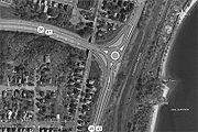 MDOT unveiled plans on March 31, 2009, to rebuild the intersection between Front Street and the eastern end of the Marquette Bypass during 2010. The rebuilt intersection would take the form of a roundabout
, replacing several intersecting roadways that connect the north and south sections of Front Street with US 41/M-28 through the existing intersection. The previous intersection configuration dated back to the 1960s. It had been labeled as "dangerous and [causing] significant traffic delays" by the designers of the replacement. A traffic study concluded in 2007 that the intersection would need either the roundabout or a traffic signal with several turning lanes to accommodate the traffic needs in the area. MDOT decided in favor of a two-lane, 150 feet (45.7 m) roundabout retaining the right-turn lanes from the previous intersection layout. These lanes will be used by right-turning traffic to bypass the circle at the center of the intersection.
The upgraded intersection had been a part of the City of Marquette's master plan since 2003. MDOT engineers touted the constant-flowing nature of the design as a benefit to the new intersection, and city planners promoted the enhanced safety aspects of the project. Both parties stated the planned intersection was less expensive than a conventional stop light.
Residents have expressed concerns about snow plowing and truck traffic in the intersection. The designers consulted officials of Avon, Colorado
, where several roundabouts are situated in a location that averages over 300 inches (762 cm) of annual snowfall. Designers planned the size of the new intersection to accommodate truck traffic. MDOT has stated that many of the concerns expressed are due to misconceptions and unfounded assumptions about the design. The department held an informational meeting with the residents on April 15, 2010 before construction began. Topics ranges from emergency vehicles, plowing, trucks, accidents and detour plans.
Construction started on the project in May. One lane of traffic in each direction was maintained for US 41/M-28. Motorist seeking access to downtown were detoured via Grove Street or Lakeshore Boulevard. The Downtown Development Authority had plans to purchase billboards helping to direct customers to the downtown shopping district. A section of the intersection was opened in July to traffic from the south that turns west. The lanes northbound into downtown were opened in the beginning of August, and the city held a ribbon cutting ceremony on August 19, 2010. The remaining lanes were opened the next day. To address residents' concerns about truck traffic through the intersection, the mayor note that truck used the roundabout after the ribbon was cut. "It just cruised right around and through. All of these people who are wondering is it big enough, can you get a firetruck on it? Yes, you can," stated Mayor John Kivela.
(NRHP) and Michigan's State Register of Historic Sites (SRHS) along with four of the others.
. A canal links the final several miles of the lake arm to Lake Superior to the northwest.
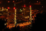 This lift bridge
features a middle section capable of being raised from a low point of 4 feet (1.2 m) of clearance over the water to a clearance of 32 feet (9.8 m) to allow boats to pass underneath. The Portage Lake Lift Bridge is the widest and heaviest double-decked vertical lift bridge in the world. The lower deck of the span was originally open to rail traffic when it was built in 1959, but this level is now closed to trains and is used in the winter for snowmobile traffic.
The lift bridge is the last of several previous crossings over the waterway. A wooden swing bridge
was built in 1875. A newer, iron swing bridge was built in 1897; this structure was partially destroyed in 1905 when it was struck by a ship. This second crossing was rebuilt in 1906 and remained in service until the lift bridge was opened in December 1959. The current bridge was last used for railroad traffic in the summer of 1982, after the Soo Line
rail lines north of Houghton were abandoned starting in 1976. The middle section is left in an intermediate position for the warmer nine months of the year so that vehicle traffic can use the lower deck of the lift span and pleasure craft can pass under the bridge. In the winter, the lift span is lowered so snowmobiles and skiers can use the lower deck while cars and trucks use the upper deck.
at the state line. This span replaced a series of bridges built to connect Marinette, Wisconsin, and Menominee, Michigan, across the river. The first bridge was built in 1865 with a second built in 1872 that was replaced in 1929 with the third bridge. This third crossing was 850 feet (259 m) in length, consisting of eleven 80 feet (24 m) spans. The bridge was rehabilitated in 1970 in a project that included widening the deck and replacing the guard rails. Another construction project in 1999 repaired the Michigan side and the slough bridge potion of the Wisconsin side of the structure; the project closed the bridge for six months.
 The Interstate Bridge was completely replaced starting on November 1, 2004, in a joint project between the MDOT and the Wisconsin Department of Transportation
. The 13-month project was budgeted to cost $6.45 million (equivalent to $ in ). Demolition started in the center of the crossing, sawing the deck into pieces for disposal. This reconstruction was completed ahead of schedule, and the span reopened on November 22, 2005. The project completely replaced the bridge above the water line with wider traffic lanes, a new bicycle lane and wider sidewalks. Images of wild rice were sculpted into the concrete because "Menominee" in the local Menominee language
means "wild rice". These sculptures were added to the other decorative elements placed on the new bridge including the railings and light poles. The new Interstate Bridge was dedicated on December 3, 2005, in a ribbon-cutting ceremony that replicated the 1930 ceremony on the previous crossing.
in Alger County. Designated Trunk Line Bridge No. 264, it carries King Road across the Whitefish River along a former alignment of US 41 built in 1919. Constructed of two 35 feet (11 m) through girders, the span continues to carry traffic although it is no longer on a state trunkline highway.
 Drivers cannot use the Peshekee River Bridge
south of US 41/M-28 in western Marquette County
's Michigamme Township
. The structure was listed on the National Register of Historic Places in 1999 for its engineering and architectural significance. MDOT has listed it on their Historic Bridge Inventory as "one of Michigan's most important vehicular bridges". It was the first bridge designed by the Michigan State Highway Department (MSHD), the forerunner to MDOT, in 1914. As the first crossing, it was designated "Trunk Line Bridge No. 1" and served as the prototype for hundreds of similar concrete through-girder bridges built in the state before the design fell out of favor in 1930. It was bypassed by a new structure built over the Peshekee River for US 41/M-28 and subsequently abandoned as a roadway, deteriorating in a county park.
Another abandoned bridge is now privately owned and in use at the mouth of the Backwater Creek on the Keweenaw Bay
near L'Anse. The span was constructed in 1918 for $4,536 (equivalent to $ in ). It is an 80 feet (24 m) Warren truss
design now situated on private property. This abandoned bridge was listed on the National Register in 1999.
One bridge still in use crosses the Sturgeon River in Baraga County, known locally as the Canyon Falls Bridge
. The structure was completed in 1948 as a steel arch bridge to span the river near the falls as part of a reconstruction project of US 41 between Ishpeming and L'Anse. The crossing has a main span of 128 feet (39 m) flanked by two 52 feet (16 m) approach spans.
The last historic bridge on US 41 is located near the northern terminus east of Copper Harbor. The Fanny Hooe Creek crossing was listed on the NRHP in 1999, but , MDOT has not included the structure on its inventory of historic bridges online. The creek crossing is just west of the Fort Wilkins State entrance. MSHD and the Keweenaw County Road Commission designed and built the span in 1927–28 for $8,132 (equivalent to $ in ). The bridge is unique for its stonework decoration on the 25 feet (8 m) span over the creek. This stonework includes fieldstones not usually associated with Michigan highway bridges. The crossing has remained in service since construction without alteration.
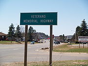 Seven memorial designations have been applied to sections of US 41. Some of these designations follow other highways that run concurrently with US 41. Most of the designations are no longer in use, but the Jacobetti and Veterans memorial highways still have signage posted on the side of the road.
The Great Lakes Automobile Route was established in 1917 by the Upper Peninsula Development Bureau. A predecessor of the Great Lakes Circle Tour
s years later, the route followed "... a circular journey along the banks of lakes Michigan and Superior and Green Bay ..." This route followed the modern US 41 from the M-28 junction in Harvey to Copper Harbor. A branch of the route followed US 2/US 41 between Powers and Rapid River. The name fell out of use before its first anniversary because of World War I
. The route was originally intended to entice motorists to drive around Lake Michigan; the side trips to Lake Superior distracted from this mission.
Sheridan Road was created in the early 20th century connecting Chicago with Fort Sheridan north of the city. Both the road and the fort were named in honor of Philip Sheridan
, Union general during the Civil War
. Sheridan, who served as colonel of the 2nd Michigan Cavalry in 1862, was later promoted to the rank of major general during the war. The Greater Sheridan Road Association started to promote an extension of the road south to St. Louis
and north through Wisconsin and Michigan to end at Fort Wilkins in Copper Harbor by 1922. The roadway followed US 41's predecessor, M-15, and included numerous road signs bearing Sheridan's silhouette mounted on his horse Rienzi. Towns along the way were encouraged to rename city streets as Sheridan Road on Labor Day
1923. The road was promoted until the Great Depression
in the 1930s. All that remains are signs in Menominee noting that First Street was once Sheridan Road.
The Townsend National Highway was named for Charles E. Townsend
, a former congressman and senator from Michigan. As a senator, he introduced the federal highway aid bill in 1919. The Michigan Good Roads Association promoted a highway in his name between Mobile, Alabama
, and Michigan. The Michigan segment followed a number of highways through the two peninsulas, including the modern US 41 between Harvey and Calumet. Only Townsend Drive in Houghton retains the name in part.
Memory Lane was created in 1947 along US 41 in Baraga. The local Lions Club planted over 100 red maple trees at the recommendation of a state highway department forester to honor the veterans of World War I and World War II
.
The Amvets Memorial Drive designation was created for the section of US 2/US 41/M-35 between the northern Escanaba city limits and CR 426 in Delta County. The American Veterans
(AMVETS) organization in Michigan petitioned the Michigan Legislature
to grant this designation which was granted under Public Act 144 in 1959.
The D. J. Jacobetti
Memorial Highway follows the segment of US 41 concurrent with M-28 between Harvey and the Ishpeming–Negaunee city limits in Marquette County. The designation was created in 1986 and continues east along M-28 to honor the longest serving member of the Michigan Legislature, elected to a record 21 terms before his death in 1994.
A section of US 41 is one of six unrelated Veterans Memorial Highway designations in Michigan. The Upper Peninsula designation follows the western end of M-28, including the section of US 41 between Ishpeming and Covington. This memorial was created in Public Act 10 of 2003 and dedicated on Memorial Day
in 2004.
 BUS US 41 in Marquette was first shown on a map in 1964 after the construction of the Marquette Bypass. It was later designated BUS US 41/BUS M-28 on a map in 1975; this second designation was removed from maps by 1982. The entire business loop was turned back to local control in a "route swap" between the City of Marquette and MDOT announced in early 2005. The proposal transferred jurisdiction on the unsigned M-554
and the business route from the state to the city. The state would take jurisdiction over a segment of McClellan Avenue to be used to extend M-553
to US 41/M-28. In addition, MDOT would pay $2.5 million (equivalent to $ in ) for reconstruction work planned for 2007. The transfer would increase Marquette's operational and maintenance liability expenses by $26,000 (equivalent to $ in ) and place the financial burden of the future replacement of a stop light on the city. On October 10, 2005, MDOT and Marquette transferred jurisdiction over the three roadways. As a result, BUS US 41 was decommissioned when the local government took control over Washington and Front streets. As a result of the decommissioning, the 2006 maps did not show the former business loop.
The third business loop was in Baraga in the early 1940s. As shown on the maps of the time, US 41 was relocated in Baraga between the publication of the December 1, 1939, and the April 15, 1940, MSHD maps. A business loop followed the old routing through downtown. The last map that shows the loop was published on July 1, 1941. BUS US 41 is shown under local control on the June 15, 1942, map.
Miami, Florida
Miami is a city located on the Atlantic coast in southeastern Florida and the county seat of Miami-Dade County, the most populous county in Florida and the eighth-most populous county in the United States with a population of 2,500,625...
, to the Upper Peninsula
Upper Peninsula of Michigan
The Upper Peninsula of Michigan is the northern of the two major land masses that make up the U.S. state of Michigan. It is commonly referred to as the Upper Peninsula, the U.P., or Upper Michigan. It is also known as the land "above the Bridge" linking the two peninsulas. The peninsula is bounded...
of the US state of Michigan
Michigan
Michigan is a U.S. state located in the Great Lakes Region of the United States of America. The name Michigan is the French form of the Ojibwa word mishigamaa, meaning "large water" or "large lake"....
. In Michigan, it is a state trunkline highway
Michigan Highway System
The Michigan State Trunkline Highway System is made up of all the highways designated as Interstates, U.S. Highways and State Highways in the US state of Michigan. The system is maintained by the Michigan Department of Transportation and comprises of trunklines in all 83 counties of Michigan on...
that enters the state via the Interstate Bridge between Marinette, Wisconsin
Marinette, Wisconsin
Marinette is a city in and the county seat of Marinette County, Wisconsin, United States. The population was 11,749 at the 2000 census.Marinette is the principal city of the Marinette, WI–MI Micropolitan Statistical Area, which includes all of Marinette County, Wisconsin and Menominee...
, and Menominee, Michigan
Menominee, Michigan
Menominee is a city in the Upper Peninsula of the U.S. state of Michigan. As of the 2000 census, the city population was 9,131. It is the county seat of Menominee County. Menominee is the fourth-largest city in the Upper Peninsula, behind Marquette, Sault Ste. Marie, and Escanaba...
. The 278.769 miles (448.634 km) of US 41 that lie within Michigan serve as a major conduit. Most of the highway is listed on the National Highway System
National Highway System (United States)
The National Highway System is a network of strategic highways within the United States, including the Interstate Highway System and other roads serving major airports, ports, rail or truck terminals, railway stations, pipeline terminals and other strategic transport facilities.Individual states...
. Various sections are rural two-lane highway, urbanized four-lane divided expressway and the Copper Country Trail National Scenic Byway
National Scenic Byway
A National Scenic Byway is a road recognized by the United States Department of Transportation for its archeological, cultural, historic, natural, recreational, and/or scenic qualities. The program was established by Congress in 1991 to preserve and protect the nation's scenic but often...
. The northernmost community along the highway is Copper Harbor
Copper Harbor, Michigan
Copper Harbor is a small unincorporated community in northeastern Keweenaw County in the U.S. state of Michigan. It is within Grant Township on the Keweenaw Peninsula that juts from the Upper Peninsula of Michigan into Lake Superior.-History:...
at the tip of the Keweenaw Peninsula
Keweenaw Peninsula
The Keweenaw Peninsula is the northern-most part of Michigan's Upper Peninsula. It projects into Lake Superior and was the site of the first copper boom in the United States. As of the 2000 census, its population was roughly 43,200...
. The trunkline ends at a cul-de-sac east of Fort Wilkins State Park after serving the Central Upper Peninsula and Copper Country
Copper Country
The Copper Country is an area in the Upper Peninsula of Michigan in the United States, including all of Keweenaw County, Michigan and most of Houghton, Baraga and Ontonagon counties. The area is so named as copper mining was prevalent there from 1845 until the late 1960s, with one mine ...
regions of Michigan.
US 41 passes through farm fields and forest lands, and along the Lake Superior
Lake Superior
Lake Superior is the largest of the five traditionally-demarcated Great Lakes of North America. It is bounded to the north by the Canadian province of Ontario and the U.S. state of Minnesota, and to the south by the U.S. states of Wisconsin and Michigan. It is the largest freshwater lake in the...
shoreline. The highway is included in the Lake Superior Circle Tour and the Lake Michigan Circle Tour and passes through the Hiawatha National Forest
Hiawatha National Forest
Hiawatha National Forest is a National Forest in the Upper Peninsula of the state of Michigan in the United States. Commercial logging is conducted in some areas. The United States Forest Service administers this National Forest; it is physically divided into two subunits, commonly called the...
and the Keweenaw National Historical Park
Keweenaw National Historical Park
Keweenaw National Historical Park is a unit of the U.S. National Park Service. Established in 1992, the park celebrates the life and history of the Keweenaw Peninsula in the Upper Peninsula of the U.S. state of Michigan...
. Historical landmarks along the trunkline include the Marquette Branch Prison
Marquette Branch Prison
The Marquette Branch Prison is located in Marquette, Michigan on the south shore of Lake Superior. The prison, which opened in 1889, is a state facility that holds about 1,100 inmates in maximum and minimum-security housing. The inmate population consists of adult males, aged twenty-one and older...
, Peshekee River Bridge and the Quincy Mine
Quincy Mine
The Quincy Mine is an extensive set of copper mines located near Hancock, Michigan. The mine was owned by the Quincy Mining Company and operated between 1846 and 1945, although some activities continued through the 1970s. The Quincy Mine was known as "Old Reliable," as the Quincy Mine Company paid...
. The highway is known for a number of historic bridges such as a lift bridge
Lift bridge
A vertical-lift bridge or lift bridge is a type of movable bridge in which a span rises vertically while remaining parallel with the deck....
, the northernmost span in the state and a structure referred to as "one of Michigan's most important vehicular bridges" by the Michigan Department of Transportation
Michigan Department of Transportation
The Michigan Department of Transportation is a constitutional government agency in the US state of Michigan. The primary purpose of MDOT is to maintain the Michigan State Trunkline Highway System which includes all Interstate, US and state highways in Michigan with the exception of the Mackinac...
(MDOT). Seven memorial highway designations have been applied to parts of the trunkline since 1917, one of them named for a Civil War
American Civil War
The American Civil War was a civil war fought in the United States of America. In response to the election of Abraham Lincoln as President of the United States, 11 southern slave states declared their secession from the United States and formed the Confederate States of America ; the other 25...
general.
US 41 was first designated as a US Highway in 1926. A section of the highway originally served as part of Military Road, a connection between Fort Wilkins and Fort Howard during the Civil War. US 41 replaced the original M-15
M-15 (Michigan highway)
M-15 is a north–south state trunkline highway in the US state of Michigan. The southern terminus is a junction with US Highway 24 just south of Clarkston on the northwestern edge of the Detroit metropolitan area. The trunkline is a recreational route running north and northwest to the...
designation of the highway which dated back to the formation of the Michigan state trunkline highway system. M-15 ran from Menominee through Marquette
Marquette, Michigan
Marquette is a city in the U.S. state of Michigan and the county seat of Marquette County. The population was 21,355 at the 2010 census, making it the most populated city of the Upper Peninsula. Marquette is a major port on Lake Superior, primarily for shipping iron ore and is the home of Northern...
to Houghton
Houghton, Michigan
Houghton is a city in the U.S. state of Michigan's Upper Peninsula and largest city in the Copper Country on the Keweenaw Peninsula. As of the 2010 census, the city population was 7,708. It is the county seat of Houghton County...
and ended in Copper Harbor. Realignments and construction projects have expanded the highway to four lanes in Delta
Delta County, Michigan
-Demographics:As of the census of 2000, there were 38,520 people, 15,836 households, and 10,689 families residing in the county. The population density was 33 people per square mile . There were 19,223 housing units at an average density of 16 per square mile...
and Marquette
Marquette County, Michigan
-National protected areas:* Hiawatha National Forest * Huron National Wildlife Refuge* Ottawa National Forest -University:Northern Michigan University is a four-year university, established in 1899, located in Marquette, Michigan, on Michigan's Upper Peninsula...
counties and have created three business loops off the main highway.
Route description
Divided Highway
Divided Highway is a compilation album by American rock band The Doobie Brothers, released in 2003. . All tracks are taken from the albums Cycles and Brotherhood .-Track listing:...
except for the sections that are concurrent
Concurrency (road)
A concurrency, overlap, or coincidence in a road network is an instance of one physical road bearing two or more different highway, motorway, or other route numbers...
with US 2
U.S. Route 2 in Michigan
US Highway 2 is a component of the United States Numbered Highway System that connects Everett, Washington, to the Upper Peninsula of the US state of Michigan, with a separate segment that runs from Rouses Point, New York, to Houlton, Maine...
near Escanaba
Escanaba, Michigan
Escanaba is a city in the U.S. state of Michigan, located in the banana belt on the state's Upper Peninsula. As of the 2000 census, the city population was 13,140, making it the third-largest city in the Upper Peninsula after Marquette and Sault Ste. Marie...
and M-28
M-28 (Michigan highway)
M-28 is an east–west state trunkline highway that almost completely traverses the Upper Peninsula in the U.S. state of Michigan, from Wakefield to near Sault Ste. Marie in Bruce Township...
near Marquette
Marquette, Michigan
Marquette is a city in the U.S. state of Michigan and the county seat of Marquette County. The population was 21,355 at the 2010 census, making it the most populated city of the Upper Peninsula. Marquette is a major port on Lake Superior, primarily for shipping iron ore and is the home of Northern...
. US 41/M-28 is a four-lane expressway
Limited-access road
A limited-access road known by various terms worldwide, including limited-access highway, dual-carriageway and expressway, is a highway or arterial road for high-speed traffic which has many or most characteristics of a controlled-access highway , including limited or no access to adjacent...
along the "Marquette Bypass", and segments of the highway in Delta
Delta County, Michigan
-Demographics:As of the census of 2000, there were 38,520 people, 15,836 households, and 10,689 families residing in the county. The population density was 33 people per square mile . There were 19,223 housing units at an average density of 16 per square mile...
and Marquette
Marquette County, Michigan
-National protected areas:* Hiawatha National Forest * Huron National Wildlife Refuge* Ottawa National Forest -University:Northern Michigan University is a four-year university, established in 1899, located in Marquette, Michigan, on Michigan's Upper Peninsula...
counties have four lanes. The route from the southern terminus to downtown Houghton
Houghton, Michigan
Houghton is a city in the U.S. state of Michigan's Upper Peninsula and largest city in the Copper Country on the Keweenaw Peninsula. As of the 2010 census, the city population was 7,708. It is the county seat of Houghton County...
is part of the National Highway System, a system of roadways considered important to the nation's economy, defense and mobility. Sections of the trunkline are on the Lake Superior and Lake Michigan circle tours.
Menominee to Rapid River
US 41 enters Michigan on the Interstate BridgeInterstate Bridge (Marinette, Wisconsin – Menominee, Michigan)
The Interstate Bridge between Marinette, Wisconsin and Menominee, Michigan carries U.S. Route 41 over the Menominee River. The current bridge was completed in November 2005 and replaced the previous span built in 1929.-History:...
connecting Marinette, Wisconsin
Marinette, Wisconsin
Marinette is a city in and the county seat of Marinette County, Wisconsin, United States. The population was 11,749 at the 2000 census.Marinette is the principal city of the Marinette, WI–MI Micropolitan Statistical Area, which includes all of Marinette County, Wisconsin and Menominee...
, and Menominee, Michigan
Menominee, Michigan
Menominee is a city in the Upper Peninsula of the U.S. state of Michigan. As of the 2000 census, the city population was 9,131. It is the county seat of Menominee County. Menominee is the fourth-largest city in the Upper Peninsula, behind Marquette, Sault Ste. Marie, and Escanaba...
. In the city of Menominee, US 41 follows 10th Avenue and 10th Street just west of downtown. The highway meets the southern terminus of M-35
M-35 (Michigan highway)
M-35 is a state trunkline highway in the Upper Peninsula of the US state of Michigan. Running for in a general north–south direction, it connects the cities of Menominee, Escanaba and Negaunee. The southern section of M-35 in Menominee and Delta counties carries two additional designations...
, with the Menominee-Marinette Airport to its west, and the waters of the Green Bay less than 1000 feet (305 m) to the east, following 10th Street out of town. The trunkline runs north through rolling farmland in the central Menominee County
Menominee County, Michigan
-Demographics:As of the census of 2000, there were 25,326 people, 10,529 households, and 7,001 families residing in the county. The population density was 24 people per square mile . There were 13,639 housing units at an average density of 13 per square mile...
communities of Wallace, Stephenson
Stephenson, Michigan
Stephenson is a city in Menominee County in the U.S. state of Michigan. The population was 875 at the 2000 census. The city is located within Stephenson Township and is part of the Marinette, WI–MI Micropolitan Statistical Area.-Geography:...
, and the twin communities of Carney
Carney, Michigan
Carney is a village in Menominee County of the U.S. state of Michigan. As of the 2000 census, the village population was 225. The village is within Nadeau Township.Carney is part of the Marinette, WI–MI Micropolitan Statistical Area.-Geography:...
and Nadeau
Nadeau Township, Michigan
Nadeau Township is a civil township of Menominee County in the U.S. state of Michigan. The population was 1,160 at the 2000 census.- Communities :...
. At Powers
Powers, Michigan
Powers is a village in Menominee County in the U.S. state of Michigan. The population was 430 at the 2000 census. It was named for John Powers, a bookkeeper for a logging company that came into the area in the late 19th century....
, US 41 joins with US 2; the two highways run concurrently and turn east toward Escanaba
Escanaba, Michigan
Escanaba is a city in the U.S. state of Michigan, located in the banana belt on the state's Upper Peninsula. As of the 2000 census, the city population was 13,140, making it the third-largest city in the Upper Peninsula after Marquette and Sault Ste. Marie...
. US 2/US 41 crosses into the Hannahville Indian Community
Hannahville Indian Community
The Hannahville Indian Community is a federally recognized Potawatomi Indian tribe residing in Michigan's Upper Peninsula, approximately 15 miles west of Escanaba. The reservation, at , lies mostly in eastern Menominee County, but a small section is located in adjacent southwestern Delta County...
at the communities of Harris in Menominee County and Bark River
Bark River, Michigan
Bark River is an unincorporated community located in Delta County in the U.S. state of Michigan. It is located in Bark River Township near the Bark River. It is situated on U.S. Highway 2 and U.S. Highway 41 about 13 miles west of Escanaba and just east of the Hannahville Indian Reservation...
in Delta County
Delta County, Michigan
-Demographics:As of the census of 2000, there were 38,520 people, 15,836 households, and 10,689 families residing in the county. The population density was 33 people per square mile . There were 19,223 housing units at an average density of 16 per square mile...
. The county line between the two communities marks the boundary between the Central and Eastern time zones.
Just west of downtown Escanaba, US 2/US 41 joins M-35 at the intersection of Ludington Street and Lincoln Road, the center of the Escanaba street grid. The trunkline enters Escanaba from the west on Ludington Street, turns north on Lincoln Road, and joins M-35. The combined highway then runs north adjacent to Little Bay de Noc
Little Bay de Noc
Little Bay de Noc is a bay in the Upper Peninsula of the U.S. state of Michigan. The bay opens into Lake Michigan's Green Bay.The bay, consisting of approximately 30,000 acres , is enclosed by Delta County...
using a four-lane divided highway to the city of Gladstone
Gladstone, Michigan
Gladstone is a city in Delta County in the U.S. state of Michigan. First settled in 1877, Gladstone's original name was Saunders Point. The population was 5,032 at the 2000 census....
, where M-35 turns west along 4th Avenue North. US 2/US 41 continues on a four-lane expressway north to Rapid River
Rapid River, Michigan
Rapid River is an unincorporated community in Masonville Township, Delta County in the U.S. state of Michigan.It is situated on the northern end of the Little Bay de Noc at , between the mouths of the Tacoosh and Rapid rivers with the mouth of the Whitefish River just to the east. U.S. Highway 2...
at the end of Little Bay de Noc. There, US 2 turns east, and US 41 turns north and inland to cross the Upper Peninsula.
The section of US 41 between Menominee and Escanaba illustrates an anomaly in the highway routing: between these two cities M-35 is the shortest state trunkline highway. Under American Association of State Highway and Transportation Officials
American Association of State Highway and Transportation Officials
AASHTO, the American Association of State Highway and Transportation Officials, is a standards setting body which publishes specifications, test protocols and guidelines which are used in highway design and construction throughout the United States...
guidelines, US Highways
United States Numbered Highways
The system of United States Numbered Highways is an integrated system of roads and highways in the United States numbered within a nationwide grid...
are to follow the most direct path between two locations, but US 41 runs inland and M-35 goes more directly up the Lake Michigan shoreline. According to the 2007 MDOT state highway map, the US 41 routing runs for 65 miles (105 km) versus 55 miles (89 km) for M-35. The original map for the US Highway System shows US 41 continuing north from Powers
Powers, Michigan
Powers is a village in Menominee County in the U.S. state of Michigan. The population was 430 at the 2000 census. It was named for John Powers, a bookkeeper for a logging company that came into the area in the late 19th century....
on a direct line to Marquette
Marquette, Michigan
Marquette is a city in the U.S. state of Michigan and the county seat of Marquette County. The population was 21,355 at the 2010 census, making it the most populated city of the Upper Peninsula. Marquette is a major port on Lake Superior, primarily for shipping iron ore and is the home of Northern...
. This routing would be more direct than the current US 41 routing via Escanaba and Rapid River, but has not been built.
Rapid River to Covington
This stretch of US 41 runs north through the western edge of the Hiawatha National ForestHiawatha National Forest
Hiawatha National Forest is a National Forest in the Upper Peninsula of the state of Michigan in the United States. Commercial logging is conducted in some areas. The United States Forest Service administers this National Forest; it is physically divided into two subunits, commonly called the...
. At Trenary, US 41 turns northwest through the southwest corner of Alger County
Alger County, Michigan
Alger County is a county in the U.S. state of Michigan. As of the 2010 census, the population was 9,601. Its county seat is Munising. The Pictured Rocks National Lakeshore is located within the county.-History:...
, crossing into Marquette County
Marquette County, Michigan
-National protected areas:* Hiawatha National Forest * Huron National Wildlife Refuge* Ottawa National Forest -University:Northern Michigan University is a four-year university, established in 1899, located in Marquette, Michigan, on Michigan's Upper Peninsula...
north of Kiva. M-94 follows US 41 for approximately 2 miles (3 km) near Skandia, before it turns westward to provide access to K. I. Saywer
K. I. Sawyer Air Force Base
K. I. Sawyer Air Force Base is a decommissioned U.S. Air Force base in Marquette County, Michigan, south of the city of Marquette. The base, near the center of Michigan's Upper Peninsula, closed in 1995. The county airport, Sawyer International, now occupies a portion of the base and has scheduled...
, a former air force base. US 41 continues northerly into the Chocolay Township community of Harvey
Harvey, Michigan
Harvey is an unincorporated community, known in the early years as "Harvey Location", in Chocolay Township, Marquette County in the U.S. state of Michigan. It is a census-designated place for statistical purposes and has no legal status as an incorporated municipality...
. It meets the eastern junction with M-28
M-28 (Michigan highway)
M-28 is an east–west state trunkline highway that almost completely traverses the Upper Peninsula in the U.S. state of Michigan, from Wakefield to near Sault Ste. Marie in Bruce Township...
in Harvey, and the two highways run concurrent for nearly 60 miles (97 km), during which they follow the Lake Superior Circle Tour.
Lake Superior
Lake Superior is the largest of the five traditionally-demarcated Great Lakes of North America. It is bounded to the north by the Canadian province of Ontario and the U.S. state of Minnesota, and to the south by the U.S. states of Wisconsin and Michigan. It is the largest freshwater lake in the...
shoreline, passing the Marquette Branch Prison
Marquette Branch Prison
The Marquette Branch Prison is located in Marquette, Michigan on the south shore of Lake Superior. The prison, which opened in 1889, is a state facility that holds about 1,100 inmates in maximum and minimum-security housing. The inmate population consists of adult males, aged twenty-one and older...
and crossing the Carp River before cresting Shiras Hill on the way into the city of Marquette
Marquette, Michigan
Marquette is a city in the U.S. state of Michigan and the county seat of Marquette County. The population was 21,355 at the 2010 census, making it the most populated city of the Upper Peninsula. Marquette is a major port on Lake Superior, primarily for shipping iron ore and is the home of Northern...
, entering town on Front Street. South of downtown, the highway turns west on the Marquette Bypass, a four-lane expressway complete with two overpasses. The bypass moves traffic around the former routing of US 41/M-28 along Front and Washington streets, a routing that was used for Business US 41
U.S. Route 41 Business (Marquette, Michigan)
US Highway 41 Business Route was a state trunkline highway that served as a business loop off US 41 in the US state of Michigan through the City of Marquette along Washington and Front streets. Jurisdiction over the two streets was transferred to the City as part of a route swap that resulted...
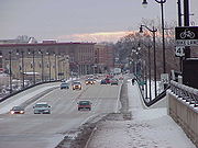
(BUS US 41) until 2005. West of Washington Street, US 41/M-28 follows a heavily trafficked business corridor. The 2006 average annual daily traffic (AADT, the yearly traffic count divided by 365) along this corridor ranged from 31,700 to 34,700 vehicles. US 41/M-28 climbs hilly terrain into the cities of Negaunee
Negaunee, Michigan
Negaunee is a city in Marquette County in the U.S. state of Michigan. The population was 4,576 at the 2000 census. The city is located at the southwest corner of Negaunee Township. The city is home to the Michigan Iron Industry Museum...
and Ishpeming
Ishpeming, Michigan
Ishpeming is a city in Marquette County in the Upper Peninsula of the U.S. state of Michigan. The population was 6,686 at the 2000 census. This is down from a higher population in the 1950s and 1960s when the economically supportive iron ore mines had a much higher employment level...
, running west and slightly south. The two cities host BUS M-28, which was once designated as ALT US 41 as well. Between the twin cities, US 41/M-28 skirts the shores of Teal Lake in Negaunee and then narrows to two lanes west of Ishpeming.
US 41/M-28 continues west through rural Marquette County and passes along the north shore of Lake Michigamme
Lake Michigamme
Lake Michigamme, one of Michigan's largest lakes, reaches a depth of over .. It covers in Marquette and Baraga County, Michigan. Van Riper State Park provides public access. The vast majority of the lake lies in Marquette County, with only its westernmost part extending into Baraga County.The...
between Champion and Michigamme
Michigamme, Michigan
Michigamme is an unincorporated community in Marquette County of the U.S. state of Michigan. It is a census-designated place for statistical purposes and without any legal status as a municipality. As of the 2000 census, the CDP population was 287....
, crossing the Peshekee River. In eastern Baraga County
Baraga County, Michigan
-National protected areas:* Keweenaw National Historical Park * Ottawa National Forest -Demographics:As of the 2000 census, there were 8,746 people, 3,353 households, and 2,223 families residing in the county. The population density was 10 people per square mile . There were 4,631 housing units...
, the highway runs along an isthmus between Lake George and Lake Ruth in the community of Three Lakes. Further west, US 41 meets the northern terminus of US 141
U.S. Route 141
U.S. Route 141 is a north–south highway in the U.S. states of Michigan and Wisconsin. US 41 is its parent route. Its northern terminus, on US 41, is near Covington, Michigan; its southern terminus, with I-43 near Bellevue, Wisconsin; it remains in existence in Green Bay, Wisconsin as a...
, which marks the western junction with M-28 near Covington
Covington, Michigan
Covington is an unincorporated community in Covington Township of Baraga County in the U.S. state of Michigan, with coordinates of on US 141 near the junction with M-28, which is a few miles west of US 41. Covington uses the ZIP code 49919.-History:...
, and the end of the M-28 concurrency.
Covington to Copper Harbor
US 41 turns north solo from Covington, crossing the Sturgeon River, on the way to the historic sawmill town of AlbertaAlberta, Michigan
Alberta is an unincorporated community in L'Anse Township of Baraga County in the U.S. state of Michigan. It is situated on U.S. Route 41 about eight miles south of the village of L'Anse at...
. Henry Ford
Henry Ford
Henry Ford was an American industrialist, the founder of the Ford Motor Company, and sponsor of the development of the assembly line technique of mass production. His introduction of the Model T automobile revolutionized transportation and American industry...
built the village to serve the sawmill in 1935. The Alberta mill supplied wood for Ford Motors until it was closed by Henry Ford II
Henry Ford II
Henry Ford II , commonly known as "HF2" and "Hank the Deuce", was the son of Edsel Ford and grandson of Henry Ford...
; the property was donated to Michigan Technological University
Michigan Technological University
Michigan Technological University is a public research university located in Houghton, Michigan, United States. Its main campus sits on on a bluff overlooking Portage Lake...
(MTU) in 1954.
Continuing north from Alberta, US 41 enters the town of L'Anse
L'Anse, Michigan
L'Anse is a village in the U.S. state of Michigan and the county seat of Baraga County. The population was 2,107 at the 2000 census. The village is located within L'Anse Township....
on the east side of Keweenaw Bay
Keweenaw Bay
Keweenaw Bay is an arm of Lake Superior in North America. It is located adjacent to the Upper Peninsula of the U.S. state of Michigan, to the southeast of the Keweenaw Peninsula. It is also the name of a small community near the bay....
, rounding the bay to the town of Baraga
Baraga, Michigan
Baraga is a village in Baraga County in the U.S. state of Michigan. The population was 1,285 at the 2000 census. The village is named after Bishop Frederic Baraga....
. Both towns are a part of the Keweenaw Bay Indian Community. US 41 continues along the shores of the bay north into Houghton County
Houghton County, Michigan
-National protected areas:* Keweenaw National Historical Park * Ottawa National Forest -Demographics:As of the census of 2000, there were 36,016 people, 13,793 households, and 8,137 families residing in the county. The population density was 36 people per square mile . There were 17,748 housing...
, turning along Portage Lake near Chassell
Chassell, Michigan
Chassell is an unincorporated community in Chassell Township of Houghton County in the Upper Peninsula of the U.S. state of Michigan. It is located on Pike Bay at the south end of Portage Lake and is the largest community in the township....
.
US 41 enters Houghton
Houghton, Michigan
Houghton is a city in the U.S. state of Michigan's Upper Peninsula and largest city in the Copper Country on the Keweenaw Peninsula. As of the 2010 census, the city population was 7,708. It is the county seat of Houghton County...
along Townsend Drive on the campus of MTU. After crossing the campus, it uses College Avenue into downtown. There, US 41 is split along the one-way pair
One-way pair
A one-way pair, one-way couple, or just couplet is a pair of parallel, usually one-way streets that carry opposite directions of a signed route or major traffic flow, or sometimes opposite directions of a bus or streetcar route....
ing of Sheldon Avenue for northbound and Montezuma Avenue for southbound traffic. The two streets merge west of downtown at the south end of the Portage Lake Lift Bridge
Portage Lake Lift Bridge
The Portage Lake Lift Bridge connects the cities of Hancock and Houghton, Michigan, USA, across Portage Lake, a portion of the waterway which cuts across the Keweenaw Peninsula with a canal linking the final several miles to Lake Superior to the northwest...
. Downtown Houghton marks the start of the Copper Country Trail National Scenic Byway.
North of the lift bridge, US 41 turns west through the downtown of Hancock
Hancock, Michigan
Hancock is a city in Houghton County; the northernmost in the U.S. state of Michigan, located on the Keweenaw Peninsula, or, depending on terminology, Copper Island. The population was 4,634 at the 2010 census...
using the one-way pairing of Quincy Street northbound and Hancock Street southbound. The trunkline then follows Lincoln Drive after merging the two directions west of downtown. The highway continues up Quincy Hill and out of town, passing the Quincy Mine
Quincy Mine
The Quincy Mine is an extensive set of copper mines located near Hancock, Michigan. The mine was owned by the Quincy Mining Company and operated between 1846 and 1945, although some activities continued through the 1970s. The Quincy Mine was known as "Old Reliable," as the Quincy Mine Company paid...
at the top of the hill. North of Hancock, US 41 passes the Houghton County Memorial Airport
Houghton County Memorial Airport
Houghton County Memorial Airport is a county-owned public-use airport located in the unincorporated community of Oneco in Franklin Township, Houghton County, Michigan, five nautical miles south west of the central business district of Calumet, a village in Houghton County, Michigan, United...
before reaching the towns of Calumet
Calumet, Michigan
Calumet is a village in Calumet Township, Houghton County, in the U.S. state of Michigan's Upper Peninsula, that was once at the center of the mining industry of the Upper Peninsula. Also known as Red Jacket, the village includes the Calumet Downtown Historic District, listed on the National...
and Laurium
Laurium, Michigan
Laurium is a village in Calumet Township, Houghton County in the U.S. state of Michigan, in the center of the Keweenaw Peninsula. The population was 2,126 at the 2000 census.-History:...
. US 41 merges with M-26
M-26 (Michigan highway)
M-26 is a state trunkline highway in the U.S. state of Michigan, running from two miles east of Rockland to its junction with US Highway 41 in Copper Harbor. It generally runs southwest-to-northeast in the western half or Michigan's Upper Peninsula...
in Calumet, and they follow the center of the Keweenaw Peninsula to the community of Phoenix
Phoenix, Michigan
Phoenix is an unincorporated community in Keweenaw County, Michigan, United States. Phoenix lies at the junction of M-26 and US 41. Phoenix lies about two miles south of Eagle River, Michigan, near the shores of Lake Superior.-Copper:...
. M-26 turns northwesterly in Phoenix to loop through Eagle River
Eagle River, Michigan
Eagle River is an unincorporated community in the U.S. state of Michigan and is the county seat of Keweenaw County.The community is on M-26 on the north side of the Keweenaw Peninsula, which projects into Lake Superior. It is about 27 miles northeast of Houghton and is situated in the northwest...
and Eagle Harbor, while US 41 turns easterly through the rural communities of Central and Delaware
Delaware, Michigan
Delaware is an unincorporated community in Keweenaw County in the U.S. state of Michigan. It was established in 1846 as a copper mining town. It is located in the Keweenaw Peninsula, ten miles south of Copper Harbor and around twenty five miles north of Calumet. When the town was first settled it...
. The two highways meet one last time in Copper Harbor
Copper Harbor, Michigan
Copper Harbor is a small unincorporated community in northeastern Keweenaw County in the U.S. state of Michigan. It is within Grant Township on the Keweenaw Peninsula that juts from the Upper Peninsula of Michigan into Lake Superior.-History:...
where M-26 ends. US 41 turns east on Gratiot Street to pass through town towards Fort Wilkins State Park. A mileage sign in Copper Harbor gives the distance down US 41 to Miami, Florida
Miami, Florida
Miami is a city located on the Atlantic coast in southeastern Florida and the county seat of Miami-Dade County, the most populous county in Florida and the eighth-most populous county in the United States with a population of 2,500,625...
, as 1990 miles (3,203 km). The roadway continues east, crossing Fanny Hooe Creek near the state park. Past the park entrance, US 41 ends at a cul-de-sac, marked by a large wooden sign.
History
There are two major eras of the history of US 41. The first dates back to the Civil WarAmerican Civil War
The American Civil War was a civil war fought in the United States of America. In response to the election of Abraham Lincoln as President of the United States, 11 southern slave states declared their secession from the United States and formed the Confederate States of America ; the other 25...
and a wagon road built by the federal government. The Military Road was built to connect the Copper Country
Copper Country
The Copper Country is an area in the Upper Peninsula of Michigan in the United States, including all of Keweenaw County, Michigan and most of Houghton, Baraga and Ontonagon counties. The area is so named as copper mining was prevalent there from 1845 until the late 1960s, with one mine ...
with Wisconsin
Wisconsin
Wisconsin is a U.S. state located in the north-central United States and is part of the Midwest. It is bordered by Minnesota to the west, Iowa to the southwest, Illinois to the south, Lake Michigan to the east, Michigan to the northeast, and Lake Superior to the north. Wisconsin's capital is...
. After the establishment of the state trunkline highway system
Michigan Highway System
The Michigan State Trunkline Highway System is made up of all the highways designated as Interstates, U.S. Highways and State Highways in the US state of Michigan. The system is maintained by the Michigan Department of Transportation and comprises of trunklines in all 83 counties of Michigan on...
, a segment of the Military Road was used for M-15
M-15 (Michigan highway)
M-15 is a north–south state trunkline highway in the US state of Michigan. The southern terminus is a junction with US Highway 24 just south of Clarkston on the northwestern edge of the Detroit metropolitan area. The trunkline is a recreational route running north and northwest to the...
, the predecessor of US 41.
Military Road
The northernmost section of the modern US 41 between Houghton and Copper Harbor originated in the 19th century as the Military Road. The road was one of 13 roads built between 1817 and 1864 by the federal government. Construction of the road was proposed as early as two years after the US acquired the last tracts of land in the Upper Peninsula. CongressUnited States Congress
The United States Congress is the bicameral legislature of the federal government of the United States, consisting of the Senate and the House of Representatives. The Congress meets in the United States Capitol in Washington, D.C....
asked Secretary of War William Wilkins
William Wilkins (U.S. politician)
William Wilkins was an American lawyer, jurist, and politician from Pittsburgh, Pennsylvania. During his career, he served in both houses of the Pennsylvania State Legislature, and in all three branches of the United States federal government, including service as a United States federal judge, as...
for funding to build such a road in 1844, since the area depended on a land connection to Green Bay, Wisconsin
Green Bay, Wisconsin
Green Bay is a city in and the county seat of Brown County in the U.S. state of Wisconsin, located at the head of Green Bay, a sub-basin of Lake Michigan, at the mouth of the Fox River. It has an elevation of above sea level and is located north of Milwaukee. As of the 2010 United States Census,...
, for up to six months a year for supplies and mail. The estimate for a 220 miles (354 km) crude road of 33 feet (10 m) was $37,400 (roughly equivalent to $ in ). The matter died until 1848 when the Michigan Legislature
Michigan Legislature
The Michigan Legislature is the legislative assembly of the U.S. state of Michigan. It is organized as a bicameral body consisting of the Senate, the upper house, and the House of Representatives, the lower house. Article IV of the state's Constitution, adopted in 1963, defines the role of the...
petitioned Congress for an appropriation to build to connect Green Bay to the Keweenaw Bay
Keweenaw Bay
Keweenaw Bay is an arm of Lake Superior in North America. It is located adjacent to the Upper Peninsula of the U.S. state of Michigan, to the southeast of the Keweenaw Peninsula. It is also the name of a small community near the bay....
. The appeal went unfulfilled by the government, but private groups stepped in. Mail service was available overland once a month during the winter from Green Bay. In 1857, the Legislature enacted a law to provide a road from Eagle Harbor south to Ontonagon
Ontonagon, Michigan
Ontonagon is a village in the U.S. state of Michigan. As of the 2000 census, the village had a total population of 1,769. It is the county seat of Ontonagon County....
. This road was extended south to the state line pursuant to two laws in 1859.
Confederate States of America
The Confederate States of America was a government set up from 1861 to 1865 by 11 Southern slave states of the United States of America that had declared their secession from the U.S...
during the early days of the war. British troops were as close to Michigan as Ontario
Ontario
Ontario is a province of Canada, located in east-central Canada. It is Canada's most populous province and second largest in total area. It is home to the nation's most populous city, Toronto, and the nation's capital, Ottawa....
, and more than half of the copper used in the US came from mines along the proposed roadway. Control of the area could have been established by seizing the Soo Locks
Soo Locks
The Soo Locks are a set of parallel locks which enable ships to travel between Lake Superior and the lower Great Lakes. They are located on the St. Marys River between Lake Superior and Lake Huron, between the Upper Peninsula of the US state of Michigan and the Canadian province of Ontario...
at Sault Ste. Marie
Sault Ste. Marie, Michigan
Sault Ste. Marie is a city in and the county seat of Chippewa County in the U.S. state of Michigan. It is in the north-eastern end of Michigan's Upper Peninsula, on the Canadian border, separated from its twin city of Sault Ste. Marie, Ontario, by the St. Marys River...
, severing communication lines through the Great Lakes
Great Lakes
The Great Lakes are a collection of freshwater lakes located in northeastern North America, on the Canada – United States border. Consisting of Lakes Superior, Michigan, Huron, Erie, and Ontario, they form the largest group of freshwater lakes on Earth by total surface, coming in second by volume...
. If the locks fell to an enemy force, no troops or supplies could be moved to the Copper Country
Copper Country
The Copper Country is an area in the Upper Peninsula of Michigan in the United States, including all of Keweenaw County, Michigan and most of Houghton, Baraga and Ontonagon counties. The area is so named as copper mining was prevalent there from 1845 until the late 1960s, with one mine ...
except by land. The road was also needed during the five or six months of the year that transportation on the Great Lakes was barred by ice or stormy weather.
Congress passed a law to build a military wagon road on March 3, 1863 from Fort Wilkins to Houghton and then south to the state line. The road was laid out in 1864 following what is today M-26
M-26 (Michigan highway)
M-26 is a state trunkline highway in the U.S. state of Michigan, running from two miles east of Rockland to its junction with US Highway 41 in Copper Harbor. It generally runs southwest-to-northeast in the western half or Michigan's Upper Peninsula...
between Copper Harbor and Phoenix, US 41 south to Houghton, M-26 south to Winona and Federal Forest Highway 16 (FFH-16) to the state line. Wisconsin authorities ran the road along what is now Highway 29
Highway 29 (Wisconsin)
State Trunk Highway 29 is a state highway running east–west across central Wisconsin. It is a major east–west corridor connecting the Twin Cities and the Chippewa Valley with Wausau and Green Bay. A multi-year project to upgrade the corridor to a four-lane freeway/expressway from Elk Mound to...
between Green Bay and Shawano
Shawano, Wisconsin
Shawano is a city in Shawano County, Wisconsin, United States. The population was 9,305 at the 2010 census. It is the county seat of Shawano County...
and Highway 55
Highway 55 (Wisconsin)
State Trunk Highway 55 is a state highway in the U.S. state of Wisconsin. It runs south–north in northeast Wisconsin from a junction with US 151 approximately 1.5 miles north of Brothertown near the eastern shore of Lake Winnebago in Calument County to the Michigan State line at the Brule...
north to the state line. Military Road would connect Fort Wilkins with Fort Howard near Green Bay.
The laws setting up the construction of the Military Road established a five-year deadline for construction. The war removed laborers in mining, lumbering and shipping as well as soldiers from the available workforce, and Congress extended the deadline an additional 21 months in June 1868. A second extension was granted in May 1870. The Wisconsin section of the highway was completed on June 20, 1870. The Houghton County segment was finished in January 1871. The Keweenaw County section was completed by August 1871. A third and final extension on the deadline was needed in April 1872, and the roadway was completed south to the state line in September 1873, shifting the southern segment in the Upper Peninsula west to the modern US 45
U.S. Route 45
U.S. Route 45 is a north–south United States highway. US 45 is a border-to-border route, from Lake Superior to the Gulf of Mexico. A sign at the highway's northern terminus notes the total distance as ....
corridor in place of the FFH-16 alignment.
In payment for the completion of the road, close to 221000 acres (89,435.6 ha) were awarded by the federal government to the corporation, including some 174000 acres (70,415.4 ha) to Dr James Ayer of Lowell, Massachusetts
Lowell, Massachusetts
Lowell is a city in Middlesex County, Massachusetts, USA. According to the 2010 census, the city's population was 106,519. It is the fourth largest city in the state. Lowell and Cambridge are the county seats of Middlesex County...
, for his investments in the company. Most of the remaining land grants went to the company behind the Portage Lake Canal near Houghton and Hancock. Ayer's holdings were controlled by the trustees of his estate after his death in July 1878. A few thousand acres were sold over time, and the trustees benefitted from the sale of timber and the mineral rights. The profits had been exhausted by 1921, and the remaining tracts were sold to a lumberman from Grand Rapids
Grand Rapids, Michigan
Grand Rapids is a city in the U.S. state of Michigan. The city is located on the Grand River about 40 miles east of Lake Michigan. As of the 2010 census, the city population was 188,040. In 2010, the Grand Rapids metropolitan area had a population of 774,160 and a combined statistical area, Grand...
for $2.3 million (roughly equivalent to $ in ).
Railroads built near the Military Road attracted more traffic than the road. The road was not well built; except in the winter when the weather froze the ground or covered it in snow, the road was barely passable. Most of the 140 miles (225 km) highway was converted into a state trunkline between 1913 and 1920, mostly as M-15 or M-26. Remnants of the original Military Road can be found as backwoods trails labeled "Old Military Road" on maps, or as a street in Ripley
Ripley, Michigan
Ripley is a small, unincorporated community in Franklin Township situated upon a slope, just east of Hancock on M-26 and across the Portage Lake Canal from Houghton....
near Hancock called "Military Road".
State trunkline
The first state trunkline highway designated along the path of the modern US 41 was M-15, in use as far back as 1919. The 1925 draft plan for the establishment of the US Highway SystemUnited States Numbered Highways
The system of United States Numbered Highways is an integrated system of roads and highways in the United States numbered within a nationwide grid...
would have replaced M-15 with three different US Highways. Between Menominee and Powers, M-15 was to follow the route that US 41 follows today. East of Powers to Rapid River, the trunkline would have been just US 2. The next segment between Rapid River and Covington was planned as US 102 while the remainder north to Copper Harbor was planned as US 41 In between Powers and Covington, US 41 was planned to follow US 2 west to Iron Mountain
Iron Mountain, Michigan
Iron Mountain is a city in the U.S. state of Michigan. As of the 2000 census, the city population was 8,154. It is the county seat of Dickinson County, in the state's Upper Peninsula....
and then route of the modern US 141
U.S. Route 141
U.S. Route 141 is a north–south highway in the U.S. states of Michigan and Wisconsin. US 41 is its parent route. Its northern terminus, on US 41, is near Covington, Michigan; its southern terminus, with I-43 near Bellevue, Wisconsin; it remains in existence in Green Bay, Wisconsin as a...
between Powers and Covington. When the system was announced on November 11, 1926, US 41 was the only US Highway routed along the alignment of M-15. The original map showed US 41 following an unbuilt alignment between Powers and Marquette. The new US 41 designation was instead routed to follow the former M-15.
The 1927 edition of the official Michigan highway service map was the first to show M-28
M-28 (Michigan highway)
M-28 is an east–west state trunkline highway that almost completely traverses the Upper Peninsula in the U.S. state of Michigan, from Wakefield to near Sault Ste. Marie in Bruce Township...
extended along US 41 into Marquette County
Marquette County, Michigan
-National protected areas:* Hiawatha National Forest * Huron National Wildlife Refuge* Ottawa National Forest -University:Northern Michigan University is a four-year university, established in 1899, located in Marquette, Michigan, on Michigan's Upper Peninsula...
and east over the former M-25
M-25 (Michigan highway)
M-25 is a state trunkline highway in the US state of Michigan. The route follows an arc-like shape closely along the Lake Huron shore of the Thumb in the eastern Lower Peninsula between Port Huron and Bay City. It serves the lakeshore resorts along Lake Huron and Saginaw Bay and generally lies...
through Munising
Munising, Michigan
Munising is a city on the southern shore of Lake Superior on the Upper Peninsula of the U.S. state of Michigan. As of the 2000 census, the city population was 2,539. It is the county seat of Alger County...
and Newberry
Newberry, Michigan
Newberry is a village in the U.S. state of Michigan and the county seat of Luce County. Located within McMillan Township at its very southern end, it shares some administrative responsibilities with the surrounding township. The population was 2,686 at the 2000 census.The village was named in...
, before ending in downtown Sault Ste. Marie
Sault Ste. Marie, Michigan
Sault Ste. Marie is a city in and the county seat of Chippewa County in the U.S. state of Michigan. It is in the north-eastern end of Michigan's Upper Peninsula, on the Canadian border, separated from its twin city of Sault Ste. Marie, Ontario, by the St. Marys River...
. At Negaunee
Negaunee, Michigan
Negaunee is a city in Marquette County in the U.S. state of Michigan. The population was 4,576 at the 2000 census. The city is located at the southwest corner of Negaunee Township. The city is home to the Michigan Iron Industry Museum...
, M-28 was shown along the previous routing of M-15 between Negaunee and Marquette for 10 miles (16 km), while US 41 ran along a portion of M-35
M-35 (Michigan highway)
M-35 is a state trunkline highway in the Upper Peninsula of the US state of Michigan. Running for in a general north–south direction, it connects the cities of Menominee, Escanaba and Negaunee. The southern section of M-35 in Menominee and Delta counties carries two additional designations...
. This southern loop routing of M-28 lasted until approximately 1936, when M-28 was displayed as concurrent with US 41. The former route is now Marquette County Road 492 (CR 492). Around 1930, the northern terminus of US 41 was extended east from Copper Harbor to Fort Wilkins State Park. Another realignment shown in 1937 marked the transfer of US 41/M-28 out of downtown Ishpeming and Negaunee. This former routing later became BUS M-28. The highway was realigned due north between Rapid River and Trenary according to the 1938 service map. US 41 was denoted on maps as completely paved in 1952. The final two sections to be shown paved were in Baraga County
Baraga County, Michigan
-National protected areas:* Keweenaw National Historical Park * Ottawa National Forest -Demographics:As of the 2000 census, there were 8,746 people, 3,353 households, and 2,223 families residing in the county. The population density was 10 people per square mile . There were 4,631 housing units...
and Keweenaw County
Keweenaw County, Michigan
-Demographics:As of the census of 2000, there were 2,301 people, 998 households, and 604 families residing in the county. The population density was 4 people per square mile . There were 2,327 housing units at an average density of 4 per square mile...
.
U.S. Route 41 Business (Marquette, Michigan)
US Highway 41 Business Route was a state trunkline highway that served as a business loop off US 41 in the US state of Michigan through the City of Marquette along Washington and Front streets. Jurisdiction over the two streets was transferred to the City as part of a route swap that resulted...
at this time. The concurrency with M-35 through Marquette and Baraga counties was removed from maps in 1968. M-35 west of Baraga was designated as a new M-38
M-38 (Michigan highway)
M-38 is an east–west state trunkline highway in the Upper Peninsula of the U.S. state of Michigan. Its west end starts in Ontonagon and runs east to Baraga, some apart. The highway crosses streams and rivers in forest lands and provides access to a casino...
and M-35 was shortened to its current northern terminus.
Another expressway section of US 41 was denoted along US 2/US 41 between Gladstone and Rapid River in 1972. A BUS M-28 designation was added to BUS US 41 on the MDOT map in 1975, making it similar to the former BUS US 41/BUS M-28 designation along BUS M-28
M-28 Business (Ishpeming-Negaunee, Michigan)
M-28 Business Route is a state trunkline highway serving as a business route that runs for through the downtown districts of Ishpeming and Negaunee in Michigan. The trunkline provides a marked route for traffic diverting from U.S. Highway 41 and M-28 through the two historic iron-mining...
in Ishpeming and Negaunee. This second designation was removed by 1982.
US 41 in the Copper Country was recognized on September 26, 1995, as the state's first scenic heritage route
Michigan Heritage Route
Michigan Heritage Route is a designation for roads in Michigan. The designation was created by the state legislature in 1993.The program emphasizes cooperation among local residents, government officials, landowners and interested groups to preserve unique scenic, historic or recreational...
. The first section given the designation ran from Central to Copper Harbor. The designation was extended south to Mohawk in 2002 and Houghton in 2004. On September 22, 2005, US 41 north of Houghton was designated the Copper Country Trail of the National Scenic Byways program.
Construction started on November 1, 2004, to replace the Interstate Bridge carrying US 41 between Marinette, Wisconsin, and Menominee. The project wrapped up on November 22, 2005, when the new bridge opened to traffic. A ribbon-cutting ceremony was held on December 3, 2005, to celebrate the replacement of the 1929 structure. In 2011, MDOT raised the speed limit along the expressway section in Delta County to 65 mph (29.1 m/s), although truck traffic remains set at 55 mph (24.6 m/s).
Marquette roundabout
Roundabout
A roundabout is the name for a road junction in which traffic moves in one direction around a central island. The word dates from the early 20th century. Roundabouts are common in many countries around the world...
, replacing several intersecting roadways that connect the north and south sections of Front Street with US 41/M-28 through the existing intersection. The previous intersection configuration dated back to the 1960s. It had been labeled as "dangerous and [causing] significant traffic delays" by the designers of the replacement. A traffic study concluded in 2007 that the intersection would need either the roundabout or a traffic signal with several turning lanes to accommodate the traffic needs in the area. MDOT decided in favor of a two-lane, 150 feet (45.7 m) roundabout retaining the right-turn lanes from the previous intersection layout. These lanes will be used by right-turning traffic to bypass the circle at the center of the intersection.
The upgraded intersection had been a part of the City of Marquette's master plan since 2003. MDOT engineers touted the constant-flowing nature of the design as a benefit to the new intersection, and city planners promoted the enhanced safety aspects of the project. Both parties stated the planned intersection was less expensive than a conventional stop light.
Residents have expressed concerns about snow plowing and truck traffic in the intersection. The designers consulted officials of Avon, Colorado
Avon, Colorado
Avon is a Home Rule Municipality that is the most populous town in Eagle County, Colorado, United States. The population was 5,561 at the 2000 census. Avon is the gateway to the Beaver Creek Resort which lies about two miles south of the town. It was the previous site of Vail Resorts before the...
, where several roundabouts are situated in a location that averages over 300 inches (762 cm) of annual snowfall. Designers planned the size of the new intersection to accommodate truck traffic. MDOT has stated that many of the concerns expressed are due to misconceptions and unfounded assumptions about the design. The department held an informational meeting with the residents on April 15, 2010 before construction began. Topics ranges from emergency vehicles, plowing, trucks, accidents and detour plans.
Construction started on the project in May. One lane of traffic in each direction was maintained for US 41/M-28. Motorist seeking access to downtown were detoured via Grove Street or Lakeshore Boulevard. The Downtown Development Authority had plans to purchase billboards helping to direct customers to the downtown shopping district. A section of the intersection was opened in July to traffic from the south that turns west. The lanes northbound into downtown were opened in the beginning of August, and the city held a ribbon cutting ceremony on August 19, 2010. The remaining lanes were opened the next day. To address residents' concerns about truck traffic through the intersection, the mayor note that truck used the roundabout after the ribbon was cut. "It just cruised right around and through. All of these people who are wondering is it big enough, can you get a firetruck on it? Yes, you can," stated Mayor John Kivela.
Historic bridges
Seven bridges along the US 41 corridor have been recognized for their historic character by various organizations. Six of the seven are listed on MDOT's Historic Bridge Inventory; the seventh not listed by MDOT is on the National Register of Historic PlacesNational Register of Historic Places
The National Register of Historic Places is the United States government's official list of districts, sites, buildings, structures, and objects deemed worthy of preservation...
(NRHP) and Michigan's State Register of Historic Sites (SRHS) along with four of the others.
Portage Lake Lift Bridge
The Portage Lake Lift Bridge connects the cities of Hancock and Houghton by crossing over the Portage Waterway, an arm of Portage Lake that cuts across the Keweenaw PeninsulaKeweenaw Peninsula
The Keweenaw Peninsula is the northern-most part of Michigan's Upper Peninsula. It projects into Lake Superior and was the site of the first copper boom in the United States. As of the 2000 census, its population was roughly 43,200...
. A canal links the final several miles of the lake arm to Lake Superior to the northwest.
Lift bridge
A vertical-lift bridge or lift bridge is a type of movable bridge in which a span rises vertically while remaining parallel with the deck....
features a middle section capable of being raised from a low point of 4 feet (1.2 m) of clearance over the water to a clearance of 32 feet (9.8 m) to allow boats to pass underneath. The Portage Lake Lift Bridge is the widest and heaviest double-decked vertical lift bridge in the world. The lower deck of the span was originally open to rail traffic when it was built in 1959, but this level is now closed to trains and is used in the winter for snowmobile traffic.
The lift bridge is the last of several previous crossings over the waterway. A wooden swing bridge
Swing bridge
A swing bridge is a movable bridge that has as its primary structural support a vertical locating pin and support ring, usually at or near to its centre of gravity, about which the turning span can then pivot horizontally as shown in the animated illustration to the right...
was built in 1875. A newer, iron swing bridge was built in 1897; this structure was partially destroyed in 1905 when it was struck by a ship. This second crossing was rebuilt in 1906 and remained in service until the lift bridge was opened in December 1959. The current bridge was last used for railroad traffic in the summer of 1982, after the Soo Line
Soo Line Railroad
The Soo Line Railroad is the primary United States railroad subsidiary of the Canadian Pacific Railway , controlled through the Soo Line Corporation, and one of seven U.S. Class I railroads. Although it is named for the Minneapolis, St. Paul and Sault Ste...
rail lines north of Houghton were abandoned starting in 1976. The middle section is left in an intermediate position for the warmer nine months of the year so that vehicle traffic can use the lower deck of the lift span and pleasure craft can pass under the bridge. In the winter, the lift span is lowered so snowmobiles and skiers can use the lower deck while cars and trucks use the upper deck.
Interstate Bridge
The Interstate Bridge was built in 1929 for $700,000 (equivalent to $ in ) to carry US 41 over the Menominee RiverMenominee River
The Menominee River is a river in northwestern Michigan and northeastern Wisconsin in the United States. It is approximately 118 mi , draining a rural forested area of northern Wisconsin and the Upper Peninsula of Michigan into Lake Michigan...
at the state line. This span replaced a series of bridges built to connect Marinette, Wisconsin, and Menominee, Michigan, across the river. The first bridge was built in 1865 with a second built in 1872 that was replaced in 1929 with the third bridge. This third crossing was 850 feet (259 m) in length, consisting of eleven 80 feet (24 m) spans. The bridge was rehabilitated in 1970 in a project that included widening the deck and replacing the guard rails. Another construction project in 1999 repaired the Michigan side and the slough bridge potion of the Wisconsin side of the structure; the project closed the bridge for six months.
Wisconsin Department of Transportation
The Wisconsin Department of Transportation, abbreviated as WisDOT, is a governmental agency of the U.S. state of Wisconsin responsible for planning, building and maintaining the state's highways...
. The 13-month project was budgeted to cost $6.45 million (equivalent to $ in ). Demolition started in the center of the crossing, sawing the deck into pieces for disposal. This reconstruction was completed ahead of schedule, and the span reopened on November 22, 2005. The project completely replaced the bridge above the water line with wider traffic lanes, a new bicycle lane and wider sidewalks. Images of wild rice were sculpted into the concrete because "Menominee" in the local Menominee language
Menominee language
The Menominee language is an Algonquian language originally spoken by the Menominee people of northern Wisconsin and Michigan. It is still spoken on the Menominee Nation lands in Northern Wisconsin in the United States....
means "wild rice". These sculptures were added to the other decorative elements placed on the new bridge including the railings and light poles. The new Interstate Bridge was dedicated on December 3, 2005, in a ribbon-cutting ceremony that replicated the 1930 ceremony on the previous crossing.
NRHP-listed bridges
Five other bridges are listed on the NRHP and the Michigan SRHS as well as on the MDOT Historic Bridge Inventory. The first is in Limestone TownshipLimestone Township, Michigan
Limestone Township is a civil township of Alger County in the U.S. state of Michigan. The population was 407 at the 2000 census.-Communities:...
in Alger County. Designated Trunk Line Bridge No. 264, it carries King Road across the Whitefish River along a former alignment of US 41 built in 1919. Constructed of two 35 feet (11 m) through girders, the span continues to carry traffic although it is no longer on a state trunkline highway.
Trunk Line Bridge No. 1
Trunk Line Bridge No. 1,The bridge is incorrectly listed as "Truck Line Bridge No. 1" in the National Register Information System database, hence it is also incorrectly listed in various websites echoing the public domain NRIS data...
south of US 41/M-28 in western Marquette County
Marquette County, Michigan
-National protected areas:* Hiawatha National Forest * Huron National Wildlife Refuge* Ottawa National Forest -University:Northern Michigan University is a four-year university, established in 1899, located in Marquette, Michigan, on Michigan's Upper Peninsula...
's Michigamme Township
Michigamme Township, Michigan
Michigamme Township is a civil township of Marquette County in the U.S. state of Michigan. The population was 377 at the 2000 census. The unincorporated community of Michigamme is located within the township.-Geography:...
. The structure was listed on the National Register of Historic Places in 1999 for its engineering and architectural significance. MDOT has listed it on their Historic Bridge Inventory as "one of Michigan's most important vehicular bridges". It was the first bridge designed by the Michigan State Highway Department (MSHD), the forerunner to MDOT, in 1914. As the first crossing, it was designated "Trunk Line Bridge No. 1" and served as the prototype for hundreds of similar concrete through-girder bridges built in the state before the design fell out of favor in 1930. It was bypassed by a new structure built over the Peshekee River for US 41/M-28 and subsequently abandoned as a roadway, deteriorating in a county park.
Another abandoned bridge is now privately owned and in use at the mouth of the Backwater Creek on the Keweenaw Bay
Keweenaw Bay
Keweenaw Bay is an arm of Lake Superior in North America. It is located adjacent to the Upper Peninsula of the U.S. state of Michigan, to the southeast of the Keweenaw Peninsula. It is also the name of a small community near the bay....
near L'Anse. The span was constructed in 1918 for $4,536 (equivalent to $ in ). It is an 80 feet (24 m) Warren truss
Truss bridge
A truss bridge is a bridge composed of connected elements which may be stressed from tension, compression, or sometimes both in response to dynamic loads. Truss bridges are one of the oldest types of modern bridges...
design now situated on private property. This abandoned bridge was listed on the National Register in 1999.
One bridge still in use crosses the Sturgeon River in Baraga County, known locally as the Canyon Falls Bridge
Canyon Falls Bridge
The Canyon Falls Bridge is a bridge located on U.S. Route 41 over the Sturgeon River in L'Anse Township, Michigan. It was listed on the National Register of Historic Places in 1999.-History:...
. The structure was completed in 1948 as a steel arch bridge to span the river near the falls as part of a reconstruction project of US 41 between Ishpeming and L'Anse. The crossing has a main span of 128 feet (39 m) flanked by two 52 feet (16 m) approach spans.
The last historic bridge on US 41 is located near the northern terminus east of Copper Harbor. The Fanny Hooe Creek crossing was listed on the NRHP in 1999, but , MDOT has not included the structure on its inventory of historic bridges online. The creek crossing is just west of the Fort Wilkins State entrance. MSHD and the Keweenaw County Road Commission designed and built the span in 1927–28 for $8,132 (equivalent to $ in ). The bridge is unique for its stonework decoration on the 25 feet (8 m) span over the creek. This stonework includes fieldstones not usually associated with Michigan highway bridges. The crossing has remained in service since construction without alteration.
Memorial designations
The Great Lakes Automobile Route was established in 1917 by the Upper Peninsula Development Bureau. A predecessor of the Great Lakes Circle Tour
Great Lakes Circle Tour
The Great Lakes Circle Tour is a designated scenic road system connecting all of the Great Lakes and the St. Lawrence River. It consists of routes for circumnavigating the lakes, either individually or collectively.-Lake Superior Circle Tour:...
s years later, the route followed "... a circular journey along the banks of lakes Michigan and Superior and Green Bay ..." This route followed the modern US 41 from the M-28 junction in Harvey to Copper Harbor. A branch of the route followed US 2/US 41 between Powers and Rapid River. The name fell out of use before its first anniversary because of World War I
World War I
World War I , which was predominantly called the World War or the Great War from its occurrence until 1939, and the First World War or World War I thereafter, was a major war centred in Europe that began on 28 July 1914 and lasted until 11 November 1918...
. The route was originally intended to entice motorists to drive around Lake Michigan; the side trips to Lake Superior distracted from this mission.
Sheridan Road was created in the early 20th century connecting Chicago with Fort Sheridan north of the city. Both the road and the fort were named in honor of Philip Sheridan
Philip Sheridan
Philip Henry Sheridan was a career United States Army officer and a Union general in the American Civil War. His career was noted for his rapid rise to major general and his close association with Lt. Gen. Ulysses S...
, Union general during the Civil War
American Civil War
The American Civil War was a civil war fought in the United States of America. In response to the election of Abraham Lincoln as President of the United States, 11 southern slave states declared their secession from the United States and formed the Confederate States of America ; the other 25...
. Sheridan, who served as colonel of the 2nd Michigan Cavalry in 1862, was later promoted to the rank of major general during the war. The Greater Sheridan Road Association started to promote an extension of the road south to St. Louis
St. Louis, Missouri
St. Louis is an independent city on the eastern border of Missouri, United States. With a population of 319,294, it was the 58th-largest U.S. city at the 2010 U.S. Census. The Greater St...
and north through Wisconsin and Michigan to end at Fort Wilkins in Copper Harbor by 1922. The roadway followed US 41's predecessor, M-15, and included numerous road signs bearing Sheridan's silhouette mounted on his horse Rienzi. Towns along the way were encouraged to rename city streets as Sheridan Road on Labor Day
Labor Day
Labor Day is a United States federal holiday observed on the first Monday in September that celebrates the economic and social contributions of workers.-History:...
1923. The road was promoted until the Great Depression
Great Depression
The Great Depression was a severe worldwide economic depression in the decade preceding World War II. The timing of the Great Depression varied across nations, but in most countries it started in about 1929 and lasted until the late 1930s or early 1940s...
in the 1930s. All that remains are signs in Menominee noting that First Street was once Sheridan Road.
The Townsend National Highway was named for Charles E. Townsend
Charles E. Townsend
Charles Elroy Townsend was a U.S. Representative and U.S. Senator from the state of Michigan.Townsend was born near Concord, Michigan and attended the common schools in Concord and Jackson and the University of Michigan at Ann Arbor. He taught school at Concord 1881-1886 and was Jackson County...
, a former congressman and senator from Michigan. As a senator, he introduced the federal highway aid bill in 1919. The Michigan Good Roads Association promoted a highway in his name between Mobile, Alabama
Mobile, Alabama
Mobile is the third most populous city in the Southern US state of Alabama and is the county seat of Mobile County. It is located on the Mobile River and the central Gulf Coast of the United States. The population within the city limits was 195,111 during the 2010 census. It is the largest...
, and Michigan. The Michigan segment followed a number of highways through the two peninsulas, including the modern US 41 between Harvey and Calumet. Only Townsend Drive in Houghton retains the name in part.
Memory Lane was created in 1947 along US 41 in Baraga. The local Lions Club planted over 100 red maple trees at the recommendation of a state highway department forester to honor the veterans of World War I and World War II
World War II
World War II, or the Second World War , was a global conflict lasting from 1939 to 1945, involving most of the world's nations—including all of the great powers—eventually forming two opposing military alliances: the Allies and the Axis...
.
The Amvets Memorial Drive designation was created for the section of US 2/US 41/M-35 between the northern Escanaba city limits and CR 426 in Delta County. The American Veterans
AMVETS
AMVETS or American Veterans is a volunteer-led organization formed by World War II veterans which accepts honorably discharged veterans as members....
(AMVETS) organization in Michigan petitioned the Michigan Legislature
Michigan Legislature
The Michigan Legislature is the legislative assembly of the U.S. state of Michigan. It is organized as a bicameral body consisting of the Senate, the upper house, and the House of Representatives, the lower house. Article IV of the state's Constitution, adopted in 1963, defines the role of the...
to grant this designation which was granted under Public Act 144 in 1959.
The D. J. Jacobetti
Dominic Jacobetti
Dominic J. Jacobetti was a Democratic politician from the U.S. state of Michigan. He holds the record as the longest-serving member of the Michigan House of Representatives, serving from 1955 until his death in 1994, representing Michigan's 108th and 109th Districts.- Early life :Dominic was born...
Memorial Highway follows the segment of US 41 concurrent with M-28 between Harvey and the Ishpeming–Negaunee city limits in Marquette County. The designation was created in 1986 and continues east along M-28 to honor the longest serving member of the Michigan Legislature, elected to a record 21 terms before his death in 1994.
A section of US 41 is one of six unrelated Veterans Memorial Highway designations in Michigan. The Upper Peninsula designation follows the western end of M-28, including the section of US 41 between Ishpeming and Covington. This memorial was created in Public Act 10 of 2003 and dedicated on Memorial Day
Memorial Day
Memorial Day is a United States federal holiday observed on the last Monday of May. Formerly known as Decoration Day, it originated after the American Civil War to commemorate the fallen Union soldiers of the Civil War...
in 2004.
Business loops
There have been three business loops for US 41: Ishpeming–Negaunee, Marquette and Baraga. Only the business loop serving Ishpeming and Negaunee is still a state-maintained trunkline, but it is no longer designated BUS US 41. US 41/M-28 was relocated to bypass the two cities' downtowns in 1937. The highway through downtown Ishpeming and Negaunee later carried the ALT US 41/ALT M-28 designation before being designated BUS M-28 in 1958. The western end of the business loop was transferred to local government control when BUS M-28 was moved along Lakeshore Drive in 1999.M-554 (Michigan highway)
M-554 was a short unsigned state trunkline highway in the US state of Michigan in the city of Marquette. This highway was transferred to the City of Marquette on October 10, 2005 in the same "route swap" that extended M-553 and decommissioned BUS US 41...
and the business route from the state to the city. The state would take jurisdiction over a segment of McClellan Avenue to be used to extend M-553
M-553 (Michigan highway)
M-553 is a north–south state trunkline highway in the Upper Peninsula of the US state of Michigan. The trunkline was originally Marquette County Road 553. It is the main highway connection between the US 41/M-28 corridor and both the Sawyer International Airport and Gwinn.M-553 was given its...
to US 41/M-28. In addition, MDOT would pay $2.5 million (equivalent to $ in ) for reconstruction work planned for 2007. The transfer would increase Marquette's operational and maintenance liability expenses by $26,000 (equivalent to $ in ) and place the financial burden of the future replacement of a stop light on the city. On October 10, 2005, MDOT and Marquette transferred jurisdiction over the three roadways. As a result, BUS US 41 was decommissioned when the local government took control over Washington and Front streets. As a result of the decommissioning, the 2006 maps did not show the former business loop.
The third business loop was in Baraga in the early 1940s. As shown on the maps of the time, US 41 was relocated in Baraga between the publication of the December 1, 1939, and the April 15, 1940, MSHD maps. A business loop followed the old routing through downtown. The last map that shows the loop was published on July 1, 1941. BUS US 41 is shown under local control on the June 15, 1942, map.