

Alger County, Michigan
Encyclopedia
Alger County is a county in the U.S. state
of Michigan
. As of the 2010 census, the population was 9,601. Its county seat
is Munising
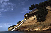
. The Pictured Rocks National Lakeshore
is located within the county.
, set off and organized in 1885.
The county was named for lumber baron Russell Alexander Alger who was a Michigan Governor
, U.S. Senator and U.S. Secretary of War during the William McKinley
Presidential administration. See also, List of Michigan county name etymologies, List of Michigan counties, and List of abolished U.S. counties.
.
, there were 9,862 people, 3,785 households, and 2,585 families residing in the county. The population density
was 11 people per square mile (4/km²). There were 5,964 housing units at an average density of 6 per square mile (3/km²). The racial makeup of the county was 87.81% White
, 6.11% Black
or African American
, 3.30% Native American
, 0.32% Asian
, 0.04% Pacific Islander
, 0.39% from other races
, and 2.03% from two or more races. 1.00% of the population were Hispanic
or Latino
of any race. 14.9% were of Finnish, 11.7% German, 9.5% French
, 7.5% Polish, 6.5% American
, 6.1% English
, 5.9% Irish
, 5.7% French Canadian
and 5.1% Swedish ancestry according to Census 2000. 95.5% spoke English
, 2.1% Finnish
and 1.7% Spanish
as their first language.
There were 3,785 households out of which 27.00% had children under the age of 18 living with them, 57.00% were married couples
living together, 7.60% had a female householder with no husband present, and 31.70% were non-families. 26.80% of all households were made up of individuals and 12.60% had someone living alone who was 65 years of age or older. The average household size was 2.35 and the average family size was 2.83.
In the county the population was spread out with 20.50% under the age of 18, 7.30% from 18 to 24, 28.70% from 25 to 44, 26.30% from 45 to 64, and 17.20% who were 65 years of age or older. The median age was 41 years. For every 100 females there were 116.60 males. For every 100 females age 18 and over, there were 120.60 males.
The median income for a household in the county was $35,892, and the median income for a family was $42,017. Males had a median income of $37,681 versus $24,492 for females. The per capita income
for the county was $18,210. About 7.20% of families and 10.30% of the population were below the poverty line, including 12.70% of those under age 18 and 8.10% of those age 65 or over.
keeps files of deeds and mortgages, maintains vital records, administers public health
regulations, and
participates with the state in the provision of welfare and other social services. The county
board of commissioners
controls the budget but has only limited authority to make laws or ordinances. In
Michigan, most local government functions — police and fire, building and zoning, tax assessment, street
maintenance, etc. — are the responsibility of individual cities and townships.
Villages
Unincorporated communities
Townships
U.S. state
A U.S. state is any one of the 50 federated states of the United States of America that share sovereignty with the federal government. Because of this shared sovereignty, an American is a citizen both of the federal entity and of his or her state of domicile. Four states use the official title of...
of Michigan
Michigan
Michigan is a U.S. state located in the Great Lakes Region of the United States of America. The name Michigan is the French form of the Ojibwa word mishigamaa, meaning "large water" or "large lake"....
. As of the 2010 census, the population was 9,601. Its county seat
County seat
A county seat is an administrative center, or seat of government, for a county or civil parish. The term is primarily used in the United States....
is Munising
Munising, Michigan
Munising is a city on the southern shore of Lake Superior on the Upper Peninsula of the U.S. state of Michigan. As of the 2000 census, the city population was 2,539. It is the county seat of Alger County...
. The Pictured Rocks National Lakeshore
Pictured Rocks National Lakeshore
Pictured Rocks National Lakeshore is a U.S. National Lakeshore on the shore of Lake Superior in the Upper Peninsula of Michigan, United States. It extends for 42 miles along the shore and covers...
is located within the county.
History
Alger County was detached from Schoolcraft CountySchoolcraft County, Michigan
-National protected areas:* Hiawatha National Forest * Seney National Wildlife Refuge-Demographics:As of the census of 2000, there were 8,903 people, 3,606 households, and 2,498 families residing in the county. The population density was 8 people per square mile . There were 5,700 housing units...
, set off and organized in 1885.
The county was named for lumber baron Russell Alexander Alger who was a Michigan Governor
Governor of Michigan
The Governor of Michigan is the chief executive of the U.S. State of Michigan. The current Governor is Rick Snyder, a member of the Republican Party.-Gubernatorial elections and term of office:...
, U.S. Senator and U.S. Secretary of War during the William McKinley
William McKinley
William McKinley, Jr. was the 25th President of the United States . He is best known for winning fiercely fought elections, while supporting the gold standard and high tariffs; he succeeded in forging a Republican coalition that for the most part dominated national politics until the 1930s...
Presidential administration. See also, List of Michigan county name etymologies, List of Michigan counties, and List of abolished U.S. counties.
Geography
According to the 2000 census, the county has a total area of 5049.08 square miles (13,077.1 km²), of which 917.83 square miles (2,377.2 km²) (or 18.18%) is land and 4131.25 square miles (10,699.9 km²) (or 81.82%) is water.County-Designated Highways
, also designated Federal Forest Highway 13., passes through Pictured Rocks National LakeshorePictured Rocks National Lakeshore
Pictured Rocks National Lakeshore is a U.S. National Lakeshore on the shore of Lake Superior in the Upper Peninsula of Michigan, United States. It extends for 42 miles along the shore and covers...
.
Adjacent counties
- Luce CountyLuce County, Michigan-Government:The county government operates the jail, maintains rural roads, operates themajor local courts, keeps files of deeds and mortgages, maintains vital records, administers...
(east) - Schoolcraft CountySchoolcraft County, Michigan-National protected areas:* Hiawatha National Forest * Seney National Wildlife Refuge-Demographics:As of the census of 2000, there were 8,903 people, 3,606 households, and 2,498 families residing in the county. The population density was 8 people per square mile . There were 5,700 housing units...
(southeast) - Delta CountyDelta County, Michigan-Demographics:As of the census of 2000, there were 38,520 people, 15,836 households, and 10,689 families residing in the county. The population density was 33 people per square mile . There were 19,223 housing units at an average density of 16 per square mile...
(south) - Marquette CountyMarquette County, Michigan-National protected areas:* Hiawatha National Forest * Huron National Wildlife Refuge* Ottawa National Forest -University:Northern Michigan University is a four-year university, established in 1899, located in Marquette, Michigan, on Michigan's Upper Peninsula...
(west) - Thunder Bay District, OntarioThunder Bay District, OntarioThunder Bay District is a district and census division in Northwestern Ontario in the Canadian province of Ontario. The district seat is Thunder Bay....
(north, water boundary only, in Lake SuperiorLake SuperiorLake Superior is the largest of the five traditionally-demarcated Great Lakes of North America. It is bounded to the north by the Canadian province of Ontario and the U.S. state of Minnesota, and to the south by the U.S. states of Wisconsin and Michigan. It is the largest freshwater lake in the...
)
National protected areas
- Grand Island National Recreation AreaGrand Island National Recreation AreaThe Grand Island National Recreation Area is a National Recreation Area within the jurisdiction of the U.S. Forest Service. It is part of the Hiawatha National Forest. Located on Grand Island, Michigan offshore from Munising, Michigan, the Grand Island National Recreation Area covers approximately ...
- Hiawatha National ForestHiawatha National ForestHiawatha National Forest is a National Forest in the Upper Peninsula of the state of Michigan in the United States. Commercial logging is conducted in some areas. The United States Forest Service administers this National Forest; it is physically divided into two subunits, commonly called the...
(part) - Pictured Rocks National LakeshorePictured Rocks National LakeshorePictured Rocks National Lakeshore is a U.S. National Lakeshore on the shore of Lake Superior in the Upper Peninsula of Michigan, United States. It extends for 42 miles along the shore and covers...
Demographics
As of the 2000 censusUnited States Census, 2000
The Twenty-second United States Census, known as Census 2000 and conducted by the Census Bureau, determined the resident population of the United States on April 1, 2000, to be 281,421,906, an increase of 13.2% over the 248,709,873 persons enumerated during the 1990 Census...
, there were 9,862 people, 3,785 households, and 2,585 families residing in the county. The population density
Population density
Population density is a measurement of population per unit area or unit volume. It is frequently applied to living organisms, and particularly to humans...
was 11 people per square mile (4/km²). There were 5,964 housing units at an average density of 6 per square mile (3/km²). The racial makeup of the county was 87.81% White
Race (United States Census)
Race and ethnicity in the United States Census, as defined by the Federal Office of Management and Budget and the United States Census Bureau, are self-identification data items in which residents choose the race or races with which they most closely identify, and indicate whether or not they are...
, 6.11% Black
Race (United States Census)
Race and ethnicity in the United States Census, as defined by the Federal Office of Management and Budget and the United States Census Bureau, are self-identification data items in which residents choose the race or races with which they most closely identify, and indicate whether or not they are...
or African American
Race (United States Census)
Race and ethnicity in the United States Census, as defined by the Federal Office of Management and Budget and the United States Census Bureau, are self-identification data items in which residents choose the race or races with which they most closely identify, and indicate whether or not they are...
, 3.30% Native American
Race (United States Census)
Race and ethnicity in the United States Census, as defined by the Federal Office of Management and Budget and the United States Census Bureau, are self-identification data items in which residents choose the race or races with which they most closely identify, and indicate whether or not they are...
, 0.32% Asian
Race (United States Census)
Race and ethnicity in the United States Census, as defined by the Federal Office of Management and Budget and the United States Census Bureau, are self-identification data items in which residents choose the race or races with which they most closely identify, and indicate whether or not they are...
, 0.04% Pacific Islander
Race (United States Census)
Race and ethnicity in the United States Census, as defined by the Federal Office of Management and Budget and the United States Census Bureau, are self-identification data items in which residents choose the race or races with which they most closely identify, and indicate whether or not they are...
, 0.39% from other races
Race (United States Census)
Race and ethnicity in the United States Census, as defined by the Federal Office of Management and Budget and the United States Census Bureau, are self-identification data items in which residents choose the race or races with which they most closely identify, and indicate whether or not they are...
, and 2.03% from two or more races. 1.00% of the population were Hispanic
Race (United States Census)
Race and ethnicity in the United States Census, as defined by the Federal Office of Management and Budget and the United States Census Bureau, are self-identification data items in which residents choose the race or races with which they most closely identify, and indicate whether or not they are...
or Latino
Race (United States Census)
Race and ethnicity in the United States Census, as defined by the Federal Office of Management and Budget and the United States Census Bureau, are self-identification data items in which residents choose the race or races with which they most closely identify, and indicate whether or not they are...
of any race. 14.9% were of Finnish, 11.7% German, 9.5% French
French people
The French are a nation that share a common French culture and speak the French language as a mother tongue. Historically, the French population are descended from peoples of Celtic, Latin and Germanic origin, and are today a mixture of several ethnic groups...
, 7.5% Polish, 6.5% American
United States
The United States of America is a federal constitutional republic comprising fifty states and a federal district...
, 6.1% English
English people
The English are a nation and ethnic group native to England, who speak English. The English identity is of early mediaeval origin, when they were known in Old English as the Anglecynn. England is now a country of the United Kingdom, and the majority of English people in England are British Citizens...
, 5.9% Irish
Irish people
The Irish people are an ethnic group who originate in Ireland, an island in northwestern Europe. Ireland has been populated for around 9,000 years , with the Irish people's earliest ancestors recorded having legends of being descended from groups such as the Nemedians, Fomorians, Fir Bolg, Tuatha...
, 5.7% French Canadian
French Canadian
French Canadian or Francophone Canadian, , generally refers to the descendents of French colonists who arrived in New France in the 17th and 18th centuries...
and 5.1% Swedish ancestry according to Census 2000. 95.5% spoke English
English language
English is a West Germanic language that arose in the Anglo-Saxon kingdoms of England and spread into what was to become south-east Scotland under the influence of the Anglian medieval kingdom of Northumbria...
, 2.1% Finnish
Finnish language
Finnish is the language spoken by the majority of the population in Finland Primarily for use by restaurant menus and by ethnic Finns outside Finland. It is one of the two official languages of Finland and an official minority language in Sweden. In Sweden, both standard Finnish and Meänkieli, a...
and 1.7% Spanish
Spanish language
Spanish , also known as Castilian , is a Romance language in the Ibero-Romance group that evolved from several languages and dialects in central-northern Iberia around the 9th century and gradually spread with the expansion of the Kingdom of Castile into central and southern Iberia during the...
as their first language.
There were 3,785 households out of which 27.00% had children under the age of 18 living with them, 57.00% were married couples
Marriage
Marriage is a social union or legal contract between people that creates kinship. It is an institution in which interpersonal relationships, usually intimate and sexual, are acknowledged in a variety of ways, depending on the culture or subculture in which it is found...
living together, 7.60% had a female householder with no husband present, and 31.70% were non-families. 26.80% of all households were made up of individuals and 12.60% had someone living alone who was 65 years of age or older. The average household size was 2.35 and the average family size was 2.83.
In the county the population was spread out with 20.50% under the age of 18, 7.30% from 18 to 24, 28.70% from 25 to 44, 26.30% from 45 to 64, and 17.20% who were 65 years of age or older. The median age was 41 years. For every 100 females there were 116.60 males. For every 100 females age 18 and over, there were 120.60 males.
The median income for a household in the county was $35,892, and the median income for a family was $42,017. Males had a median income of $37,681 versus $24,492 for females. The per capita income
Per capita income
Per capita income or income per person is a measure of mean income within an economic aggregate, such as a country or city. It is calculated by taking a measure of all sources of income in the aggregate and dividing it by the total population...
for the county was $18,210. About 7.20% of families and 10.30% of the population were below the poverty line, including 12.70% of those under age 18 and 8.10% of those age 65 or over.
Government
The county government operates the jail, maintains rural roads, operates the major local courts,keeps files of deeds and mortgages, maintains vital records, administers public health
Public health
Public health is "the science and art of preventing disease, prolonging life and promoting health through the organized efforts and informed choices of society, organizations, public and private, communities and individuals" . It is concerned with threats to health based on population health...
regulations, and
participates with the state in the provision of welfare and other social services. The county
board of commissioners
County commission
A county commission is a group of elected officials charged with administering the county government in local government in some states of the United States. County commissions are usually made up of three or more individuals...
controls the budget but has only limited authority to make laws or ordinances. In
Michigan, most local government functions — police and fire, building and zoning, tax assessment, street
maintenance, etc. — are the responsibility of individual cities and townships.
Alger County elected officials
(information as of August 2007)- Prosecuting AttorneyProsecutorThe prosecutor is the chief legal representative of the prosecution in countries with either the common law adversarial system, or the civil law inquisitorial system...
: Karen Bahrman - SheriffSheriffA sheriff is in principle a legal official with responsibility for a county. In practice, the specific combination of legal, political, and ceremonial duties of a sheriff varies greatly from country to country....
: David M. Cromell - County Clerk/Register of Deeds: Mary Ann Froberg
- County TreasurerTreasurerA treasurer is the person responsible for running the treasury of an organization. The adjective for a treasurer is normally "tresorial". The adjective "treasurial" normally means pertaining to a treasury, rather than the treasurer.-Government:...
: Howard Masters - Commissioner, District 1: Catherine Pullen (chair)
- Commissioner, District 2: Todd Brock
- Commissioner, District 3: Esley Mattson
- Commissioner, District 4: Donald Sandstrom
- Commissioner, District 5: Edward Lindstrom
Cities, villages, and townships
Cities- MunisingMunising, MichiganMunising is a city on the southern shore of Lake Superior on the Upper Peninsula of the U.S. state of Michigan. As of the 2000 census, the city population was 2,539. It is the county seat of Alger County...
Villages
- ChathamChatham, MichiganChatham is a village in Rock River Township of Alger County in the U.S. state of Michigan. As of the 2000 census, the village population was 231...
Unincorporated communities
- Au TrainAu Train, MichiganAu Train is an unincorporated community located in Au Train Township of Alger County in the U.S. state of Michigan. It is in the north of the western section of the Hiawatha National Forest. Au Train is at . The ZIP code is 49806 and the FIPS place code is 04440.The community sits at the foot of...
- ChristmasChristmas, MichiganChristmas is an unincorporated community in Au Train Township of Alger County in the Upper Peninsula of the U.S. state of Michigan. It is located on M-28 a few miles northwest of Munising at . Christmas is located near the Bay Furnace campgrounds on Lake Superior in the Hiawatha National Forest...
- Coalwood
- Deerton
- Diffin
- Dixon
- Dorsey
- Doty
- Eben Junction
- Evelyn
- Grand MaraisGrand Marais, MichiganGrand Marais is an unincorporated community in Burt Township, Alger County in the U.S. state of Michigan. It is located on Lake Superior at and is the eastern gateway to the Pictured Rocks National Lakeshore via H-58....
- Green Haven
- Indian Town
- Juniper
- Kentucky
- Kiva
- Ladoga
- Limestone
- Melstrand
- Munising Junction
- Myren
- Rumely
- Shingleton
- Slapneck
- Star
- Stillman
- Sundell
- Traunik
- Trenary
- Vail
- Van Meer
- Wetmore
Townships
- Au Train TownshipAu Train Township, MichiganAu Train Township is a civil township of Alger County in the U.S. state of Michigan. As of the 2000 census, the township population was 1,172.-Communities:...
- Burt TownshipBurt Township, Alger County, MichiganBurt Township is a civil township of Alger County in the U.S. state of Michigan. As of the 2000 census, the township population was 480.-Communities:There are no incorporated municipalities in the township...
- Grand Island TownshipGrand Island Township, MichiganGrand Island Township is a civil township of Alger County in the U.S. state of Michigan. The township consists entirely of the Grand Island in Lake Superior just north of Munising. As of the 2000 census, the township population was 45...
- Limestone TownshipLimestone Township, MichiganLimestone Township is a civil township of Alger County in the U.S. state of Michigan. The population was 407 at the 2000 census.-Communities:...
- Mathias TownshipMathias Township, MichiganMathias Township is a civil township of Alger County in the U.S. state of Michigan. The population was 571 at the 2000 census.-Communities:*Trenary is an unincorporated community at . The town's name is familiar to many in the Upper Midwest, especially in the Upper Peninsula of Michigan...
- Munising TownshipMunising Township, MichiganMunising Township is a civil township of Alger County in the U.S. state of Michigan. As of the 2000 census, the township population was 3,125.-Communities:...
- Onota TownshipOnota Township, MichiganOnota Township is a civil township of Alger County in the U.S. state of Michigan. As of the 2000 census, the township population was 310.-Communities:There are no incorporated municipalities in the township....
- Rock River TownshipRock River Township, MichiganRock River Township is a civil township of Alger County in the U.S. state of Michigan. The population was 1,213 at the 2000 census.-Communities:* Chatham is a village at the junction of M-67 and M-94....