

Lift bridge
Encyclopedia
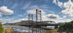
A vertical-lift bridge or lift bridge is a type of movable bridge in which a span
rises vertically while remaining parallel with the deck.
The vertical lift offers several benefits over other movable bridges such as the bascule
and swing-span bridge
. Generally speaking they cost less to build for longer moveable spans. The counterweights in a vertical lift are only required to be equal to the weight of the deck, whereas bascule bridge counterweights must weigh several times as much as the span being lifted. As a result, heavier materials can be used in the deck, and so this type of bridge is especially suited for heavy railroad use.
Although most vertical-lift bridges use towers, each equipped with counterweights, some use hydraulic jacks located below the deck. An example is the 16 metres (52.5 ft) span bridge at St Paul Avenue in Milwaukee (see also table bridge
s). Another design used balance beams to lift the deck, with pivoting bascules located on the top of the lift towers. An example of this kind was built at La Salle in Illinois, USA.
The biggest disadvantage to the vertical-lift bridge (in comparison with many other designs) is the height restriction for vessels passing under it. This is a result of the deck remaining suspended above the passageway.


Span (architecture)
Span is the distance between two intermediate supports for a structure, e.g. a beam or a bridge.A span can be closed by a solid beam or of a rope...
rises vertically while remaining parallel with the deck.
The vertical lift offers several benefits over other movable bridges such as the bascule
Bascule bridge
A bascule bridge is a moveable bridge with a counterweight that continuously balances the span, or "leaf," throughout the entire upward swing in providing clearance for boat traffic....
and swing-span bridge
Swing bridge
A swing bridge is a movable bridge that has as its primary structural support a vertical locating pin and support ring, usually at or near to its centre of gravity, about which the turning span can then pivot horizontally as shown in the animated illustration to the right...
. Generally speaking they cost less to build for longer moveable spans. The counterweights in a vertical lift are only required to be equal to the weight of the deck, whereas bascule bridge counterweights must weigh several times as much as the span being lifted. As a result, heavier materials can be used in the deck, and so this type of bridge is especially suited for heavy railroad use.
Although most vertical-lift bridges use towers, each equipped with counterweights, some use hydraulic jacks located below the deck. An example is the 16 metres (52.5 ft) span bridge at St Paul Avenue in Milwaukee (see also table bridge
Table bridge
A table bridge is a moveable bridge in which the deck moves along the vertical axis. Hydraulic pillars under the bridge raise the bridge deck to allow barge traffic to pass beneath it. In contrast to a lift bridge, where the deck is pulled upwards along towers, the deck of a table bridge is pushed...
s). Another design used balance beams to lift the deck, with pivoting bascules located on the top of the lift towers. An example of this kind was built at La Salle in Illinois, USA.
The biggest disadvantage to the vertical-lift bridge (in comparison with many other designs) is the height restriction for vessels passing under it. This is a result of the deck remaining suspended above the passageway.
Australia
- Ryde BridgeRyde BridgeThe Ryde Bridge, which is in fact two bridges, is located in Sydney, Australia that crosses the Parramatta River, linking the suburb of Ryde in Sydney's Northern Suburbs to the suburb of Rhodes in Sydney's Inner West...
- road - Ryde, New South WalesRyde, New South WalesRyde is a suburb of Sydney, New South Wales, Australia. Ryde is located 13 km north-west of the Sydney central business district and 8 km east of Parramatta. Ryde is the administrative centre of the local government area of the City of Ryde and part of the Northern Suburbs area...
- opened 1935, now permanently lowered - Harwood BridgeHarwood BridgeThe Harwood Bridge is a steel truss bridge which carries the Pacific Highway in New South Wales, Australia over the Clarence River .It crosses the main channel of the Clarence River, about 10 km upstream from the river mouth, and 46 km north of Grafton. It is located 3 km from the...
- road - Harwood Island, New South Wales - opened 1966 - Port AdelaidePort AdelaidePort Adelaide is a suburb of Adelaide lying about 14 kilometres northwest of the City of Adelaide. It lies within the City of Port Adelaide Enfield and is the main port for the city of Adelaide...
- rail - opened 2008 - Bridgewater Bridge - road & rail - Bridgewater, TasmaniaBridgewater, TasmaniaBridgewater, Tasmania, is one greater Hobart's northern-most suburbs, located 19 km from the city. It is situated on the eastern shore of the Derwent River. It is a suburb of the local government area of the Municipality of Brighton....
- opened - Clyde River Bridge - road - Batemans Bay, New South WalesBatemans Bay, New South Wales- Media :Radio Stations*East Coast Radio 2EC *Power FM NSW South Coast - POWER FM from Nowra can also be received in parts of Batemans Bay on FM 94.9....
- opened 1956 - Hobart BridgeHobart BridgeThe Hobart Bridge was a pontoon bridge that crossed the River Derwent, connecting the eastern and western Shores of the City of Hobart, Tasmania, Australia.- History :...
- road - Hobart, Tasmania - opened 1943, closed 1964 and demolished afterwards
Canada
- Bridges 5 (Glendale Avenue Bridge), 11 (Allanburg Bridge) and 21 (Clarence Street Bridge) on the Welland CanalWelland CanalThe Welland Canal is a ship canal in Canada that extends from Port Weller, Ontario, on Lake Ontario, to Port Colborne, Ontario, on Lake Erie. As a part of the St...
, all built during the late 1920s as part of the Fourth Canal expansion project (1913–1932). In addition, there are also Bridges 13 (Main Street Bridge), 17 (Dain City Railway Bridge) and 18 (Forks Road Bridge) on the Welland Recreational WaterwayWelland Recreational WaterwayThe Welland Recreational Waterway is a water channel in the city of Welland, Ontario, Canada. It is an old alignment of the Welland Ship Canal that has been abandoned after the construction of the Welland By-Pass in the 1970s. The Waterway is now managed by the Welland Recreational Canal...
(a former channel of the Welland Canal). However, these bridges have not been operational since 1973. Bridges 13 and 18 have had their counterweights removed while the machinery for Bridge 17 has been dismantled. In addition, Bridge 18 no longer possesses its towers; they were removed for ease of maintenance. - Burlington Lift Bridge, over the Burlington Canal, Burlington, OntarioBurlington, OntarioBurlington , is a city located in Halton Region at the western end of Lake Ontario. Burlington is part of the Greater Toronto Area, and is also included in the Hamilton Census Metropolitan Area. Physically, Burlington lies between the north shore of Lake Ontario and the Niagara Escarpment...
. Information is available from Transport Canada - Pretoria BridgePretoria BridgeThe Pretoria Bridge is a lift bridge in Ottawa, Canada. It crosses the Rideau Canal linking the Glebe and Centretown to Old Ottawa East. The bridge was built in 1915, replacing an earlier wooden swing bridge on Argyle Street just to the north...
over the Rideau CanalRideau CanalThe Rideau Canal , also known as the Rideau Waterway, connects the city of Ottawa, Ontario, Canada on the Ottawa River to the city of Kingston, Ontario on Lake Ontario. The canal was opened in 1832 as a precaution in case of war with the United States and is still in use today, with most of its...
in OttawaOttawaOttawa is the capital of Canada, the second largest city in the Province of Ontario, and the fourth largest city in the country. The city is located on the south bank of the Ottawa River in the eastern portion of Southern Ontario...
, OntarioOntarioOntario is a province of Canada, located in east-central Canada. It is Canada's most populous province and second largest in total area. It is home to the nation's most populous city, Toronto, and the nation's capital, Ottawa.... - Selkirk Lift Bridge over the Red RiverRed River of the NorthThe Red River is a North American river. Originating at the confluence of the Bois de Sioux and Otter Tail rivers in the United States, it flows northward through the Red River Valley and forms the border between the U.S. states of Minnesota and North Dakota before continuing into Manitoba, Canada...
in Selkirk, ManitobaSelkirk, ManitobaSelkirk is a city in the western Canadian province of Manitoba, located about 22 km northeast of the provincial capital Winnipeg on the Red River, near . As of the 2006 census, Selkirk had a population of 9,515.... - Victoria BridgeVictoria Bridge (Montreal)Victoria Bridge , formerly originally known as Victoria Jubilee Bridge, is a bridge over the St. Lawrence River, linking Montreal, Quebec, to the south shore city of Saint-Lambert....
over the Saint Lawrence RiverSaint Lawrence RiverThe Saint Lawrence is a large river flowing approximately from southwest to northeast in the middle latitudes of North America, connecting the Great Lakes with the Atlantic Ocean. It is the primary drainage conveyor of the Great Lakes Basin...
connecting Saint-LambertSaint-Lambert, QuebecSaint-Lambert is a Canadian city in the province of Quebec located opposite Montreal on the south shore of the St. Lawrence River. Saint-Lambert was named for either the early French Canadian hunter Lambert Closse or for Roman Catholic Bishop Lambert of Maastricht...
and MontrealMontrealMontreal is a city in Canada. It is the largest city in the province of Quebec, the second-largest city in Canada and the seventh largest in North America...
, QuebecQuebecQuebec or is a province in east-central Canada. It is the only Canadian province with a predominantly French-speaking population and the only one whose sole official language is French at the provincial level....
. - Second Narrows BridgeSecond Narrows BridgeThe Second Narrows Bridge is a vertical lift railway bridge that crosses the Burrard Inlet and connects Vancouver with the North Shore. As the name suggests, it is located at the second narrowing of the Burrard Inlet....
VancouverVancouverVancouver is a coastal seaport city on the mainland of British Columbia, Canada. It is the hub of Greater Vancouver, which, with over 2.3 million residents, is the third most populous metropolitan area in the country,...
, BCBritish ColumbiaBritish Columbia is the westernmost of Canada's provinces and is known for its natural beauty, as reflected in its Latin motto, Splendor sine occasu . Its name was chosen by Queen Victoria in 1858...
over Burrard InletBurrard InletBurrard Inlet is a relatively shallow-sided coastal fjord in southwestern British Columbia, Canada. Formed during the last Ice Age, it separates the City of Vancouver and the rest of the low-lying Burrard Peninsula from the slopes of the North Shore Mountains, home to the communities of West...
(rail bridge). - Okanagan Lake BridgeOkanagan Lake BridgeThe Okanagan Lake Bridge was a three-lane, 2,100 foot/650 metre-long floating bridge in British Columbia, Canada. It crossed Okanagan Lake, connecting the Westside area to Kelowna on the lake's eastern side. Taller boats such as sailboats were able to pass under the lift span which was located at...
in KelownaKelownaKelowna is a city on Okanagan Lake in the Okanagan Valley, in the southern interior of British Columbia, Canada. Its name derives from a Okanagan language term for "grizzly bear"...
, BCBritish ColumbiaBritish Columbia is the westernmost of Canada's provinces and is known for its natural beauty, as reflected in its Latin motto, Splendor sine occasu . Its name was chosen by Queen Victoria in 1858...
across Okanagan LakeOkanagan LakeOkanagan Lake is a large, deep lake in the Okanagan Valley of British Columbia. The lake is 135 km long, between 4 and 5 km wide, and has a surface area of 351 km². The lake's maximum depth is 232 meters near Grant Island...
- replaced in 2008. - Shippagan Bridge Shippagan, NB over Shippagan Bay.
- Sir Ambrose Shea Bridge, Placentia, NL. Built 1961.
France
- Pont Gustave-FlaubertPont Gustave-FlaubertThe Pont Gustave-Flaubert is a vertical lift bridge over the River Seine at Rouen, Seine-Maritime, Haute-Normandie, France...
- Crossing the SeineSeineThe Seine is a -long river and an important commercial waterway within the Paris Basin in the north of France. It rises at Saint-Seine near Dijon in northeastern France in the Langres plateau, flowing through Paris and into the English Channel at Le Havre . It is navigable by ocean-going vessels...
at RouenRouenRouen , in northern France on the River Seine, is the capital of the Haute-Normandie region and the historic capital city of Normandy. Once one of the largest and most prosperous cities of medieval Europe , it was the seat of the Exchequer of Normandy in the Middle Ages...
this lift bridge is the highest lift bridge in EuropeEuropeEurope is, by convention, one of the world's seven continents. Comprising the westernmost peninsula of Eurasia, Europe is generally 'divided' from Asia to its east by the watershed divides of the Ural and Caucasus Mountains, the Ural River, the Caspian and Black Seas, and the waterways connecting...
, allowing ships up to 55 m tall to pass under it. It is 670 m long, with a span of 116 m. A striking design feature, the two road sections are mounted outside the central towers. The bridge was designed by François Gillard and Aymeric Zublena and opened to road traffic on 25 September 2008. It is named after the author Gustave FlaubertGustave FlaubertGustave Flaubert was a French writer who is counted among the greatest Western novelists. He is known especially for his first published novel, Madame Bovary , and for his scrupulous devotion to his art and style.-Early life and education:Flaubert was born on December 12, 1821, in Rouen,...
who was born in RouenRouenRouen , in northern France on the River Seine, is the capital of the Haute-Normandie region and the historic capital city of Normandy. Once one of the largest and most prosperous cities of medieval Europe , it was the seat of the Exchequer of Normandy in the Middle Ages...
. - Pont de Recouvrance - Over the Penfeld in BrestBrest, FranceBrest is a city in the Finistère department in Brittany in northwestern France. Located in a sheltered position not far from the western tip of the Breton peninsula, and the western extremity of metropolitan France, Brest is an important harbour and the second French military port after Toulon...
giving access to the military arsenal. - Pont Levant de Crimée - Over the Ourcq Canal, the last surviving lift bridge in ParisParisParis is the capital and largest city in France, situated on the river Seine, in northern France, at the heart of the Île-de-France region...
Indonesia
- Jembatan Ampera (Ampera Bridge) - an automobile lift bridge located in Palembang that cross the Musi River. This bridge is still used by road vehicles but it never lift its road deck again.
Japan
- Chikugo River Lift BridgeChikugo River Lift BridgeThe is a vertical lift railway bridge across the Chikugo River in Kyūshū, Japan. It was completed in 1935. The bridge has a total length of , with a moveable span of long and a vertical rise of . It links Ōkawa, Fukuoka with Morodomi, Saga, and previously was part of the Saga Railway Line. When...
- connecting Ōkawa, FukuokaOkawa, Fukuokais a city located in Fukuoka, Japan.As of October 1, 2007, the city has an estimated population of 38,374 and the density of 1,140 persons per km². The total area is 33.61 km².The city was founded on April 1, 1954. The name means 'big river'.-Geography:...
and Saga, SagaSaga, Sagais the capital of Saga Prefecture, located on the island of Kyūshū, Japan.Saga was the capital of Saga Domain in the Edo period, and largest city of former Hizen Province....
. Constructed as a railway bridge in 1935, it is 507 m long, with a central span 24 m long that weighs 48 t and rises 23 m. The railway closed in 1987, but the bridge reopened to pedestrians in 1996 and was designated an important cultural property in 2003.
The Netherlands
- Gouwe - three identical lift bridges crossing the Gouwe river at Alphen aan den RijnAlphen aan den RijnAlphen aan den Rijn is a town and municipality in the western Netherlands, in the province of South Holland, between Leiden and Utrecht. The town is situated on the banks of the river Oude Rijn , where the river Gouwe branches off. The municipality had a population of 72,674 in 2010, and covers an...
, BoskoopBoskoopBoskoop is a town and municipality in the western Netherlands, in the province of South Holland. The municipality had a population of 15,217 in 2008, and covers an area of 16.96 km² of which 2.17 km² is water...
and WaddinxveenWaddinxveenWaddinxveen is a town and municipality along the Gouwe river in the western Netherlands in the province of South Holland near Gouda. The municipality had a population of 26,304 in 2004, 25.328 on new year's eve of 2010. and covers an area of 29.39 km² .In Waddinxveen, there's the so-called...
, built in 1930.
Germany
- Kattwyk-Brücke, in Hamburg
United States
- Aerial Lift BridgeAerial Lift BridgeThe Aerial Lift Bridge is a major landmark in the port city of Duluth, Minnesota. The span is a vertical lift bridge, which is rather uncommon, but it began life as an extremely rare transporter bridge—the first of just two such bridges ever constructed in the United States...
- An automobile bridge in Duluth, MinnesotaDuluth, MinnesotaDuluth is a port city in the U.S. state of Minnesota and is the county seat of Saint Louis County. The fourth largest city in Minnesota, Duluth had a total population of 86,265 in the 2010 census. Duluth is also the second largest city that is located on Lake Superior after Thunder Bay, Ontario,...
which began life as an aerial transfer or ferry bridge. - Arthur Kill Vertical Lift BridgeArthur Kill Vertical Lift BridgeThe Arthur Kill Vertical Lift Railroad Bridge is a railroad-only, vertical lift bridge connecting Elizabethport, New Jersey and the Howland Hook Marine Terminal on Staten Island. The bridge was built by the Baltimore and Ohio Railroad in 1959 to replace an older swing span...
- Connecting Elizabeth, New JerseyElizabeth, New JerseyElizabeth is a city in Union County, New Jersey, United States. As of the 2010 United States Census, the city had a total population of 124,969, retaining its ranking as New Jersey's fourth largest city with an increase of 4,401 residents from its 2000 Census population of 120,568...
, and Staten IslandStaten IslandStaten Island is a borough of New York City, New York, United States, located in the southwest part of the city. Staten Island is separated from New Jersey by the Arthur Kill and the Kill Van Kull, and from the rest of New York by New York Bay...
, New YorkNew YorkNew York is a state in the Northeastern region of the United States. It is the nation's third most populous state. New York is bordered by New Jersey and Pennsylvania to the south, and by Connecticut, Massachusetts and Vermont to the east...
; with a lift with a 559 feet (170.4 m) span: the longest lift span in the world. - ASB BridgeASB BridgeThe Armour-Swift-Burlington Bridge, also known as the North Kansas City Bridge, is a rail crossing over the Missouri River in Kansas City, Missouri that formerly also handled car traffic....
- A two-deck bridge over the Missouri RiverMissouri RiverThe Missouri River flows through the central United States, and is a tributary of the Mississippi River. It is the longest river in North America and drains the third largest area, though only the thirteenth largest by discharge. The Missouri's watershed encompasses most of the American Great...
in Kansas City, MissouriKansas City, MissouriKansas City, Missouri is the largest city in the U.S. state of Missouri and is the anchor city of the Kansas City Metropolitan Area, the second largest metropolitan area in Missouri. It encompasses in parts of Jackson, Clay, Cass, and Platte counties...
. From 1911–87, handled both trains and cars, on separate decks, and still carries railroad traffic. - Broadway Bridge - A bridge spanning the Harlem RiverHarlem RiverThe Harlem River is a navigable tidal strait in New York City, USA that flows 8 miles between the Hudson River and the East River, separating the boroughs of Manhattan and the Bronx...
and carrying both road traffic and trains of the New York City SubwayNew York City SubwayThe New York City Subway is a rapid transit system owned by the City of New York and leased to the New York City Transit Authority, a subsidiary agency of the Metropolitan Transportation Authority and also known as MTA New York City Transit...
's no. 1 line1 (New York City Subway service)The 1 Broadway – Seventh Avenue Local is a rapid transit service of the New York City Subway. It is colored red on station signs, route signs and the official subway map, since it uses the IRT Broadway – Seventh Avenue Line for its entire route....
. - Burlington-Bristol BridgeBurlington-Bristol BridgeThe Burlington–Bristol Bridge is a truss bridge with a lift span crossing the Delaware River from Burlington, New Jersey to Bristol Township, Pennsylvania in the United States. Construction of the bridge started on April 1, 1930, and the bridge opened to traffic on May 2, 1931...
- A two-lane bridge over the Delaware RiverDelaware RiverThe Delaware River is a major river on the Atlantic coast of the United States.A Dutch expedition led by Henry Hudson in 1609 first mapped the river. The river was christened the South River in the New Netherland colony that followed, in contrast to the North River, as the Hudson River was then...
, joining Bristol, PennsylvaniaBristol, PennsylvaniaBristol is a borough in Bucks County, Pennsylvania, northeast of Philadelphia opposite Burlington, N.J. on the Delaware River. Bristol was first incorporated in 1720. Although its charter was revised in 1905, the original charter remains in effect, making Bristol one of the older boroughs in...
with Burlington, New JerseyBurlington, New JerseyBurlington is a city in Burlington County, New Jersey, United States and a suburb of Philadelphia. As of the 2010 United States Census, the city population was 9,920....
near Philadelphia - The BNSF Railroad BridgeBurlington Northern Railroad Bridge 5.1The Burlington Northern Railroad Bridge 5.1 or BNSF Railway Bridge 5.1, also known as the St. Johns Railroad Bridge or the Willamette River Railroad Bridge, is a through truss railway bridge with a vertical lift that spans the Willamette River in Portland, Oregon, United States...
across the Willamette RiverWillamette RiverThe Willamette River is a major tributary of the Columbia River, accounting for 12 to 15 percent of the Columbia's flow. The Willamette's main stem is long, lying entirely in northwestern Oregon in the United States...
, in Portland, OregonPortland, OregonPortland is a city located in the Pacific Northwest, near the confluence of the Willamette and Columbia rivers in the U.S. state of Oregon. As of the 2010 Census, it had a population of 583,776, making it the 29th most populous city in the United States...
. The 516 feet (157.3 m) lift span replaced a swing spanSwing bridgeA swing bridge is a movable bridge that has as its primary structural support a vertical locating pin and support ring, usually at or near to its centre of gravity, about which the turning span can then pivot horizontally as shown in the animated illustration to the right...
in 1989 and, with 200 ft (61 m) of clearance underneath when raised, it is one of highest vertical-lift bridges in the world. - Canal Street railroad bridgeCanal Street railroad bridgeThe Canal Street railroad bridge is a vertical lift bridge across the south branch of the Chicago River in Chicago, Illinois. When it was constructed in 1914 its 1500 ton main span was the heaviest of any vertical lift bridge in the United States...
- Chicago, IL 1914 - Cape Cod Canal Railroad BridgeCape Cod Canal Railroad Bridge- External links :*...
- A single-track railroad bridge over the Cape Cod CanalCape Cod CanalThe Cape Cod Canal is an artificial waterway traversing the narrow neck of land that joins Cape Cod to mainland Massachusetts.Part of the Atlantic Intracoastal Waterway, the canal is roughly 17.4 miles long and connects Cape Cod Bay in the north to Buzzards Bay in the south...
in Bourne, MassachusettsBourne, MassachusettsBourne is a town in Barnstable County, Massachusetts, United States. The population was 18,721 at the 2000 census.For geographic and demographic information on specific parts of the town of Bourne, please see the articles on Bourne , Buzzards Bay, Monument Beach, Pocasset, Sagamore, and Sagamore...
.
- Cape Fear Memorial BridgeCape Fear Memorial BridgeThe Cape Fear Memorial Bridge is a steel vertical-lift bridge in North Carolina. It carries U.S. Route 17 Business, U.S. Route 76, and U.S. Route 421 across the Cape Fear River between Brunswick County and New Hanover County. It also carried U.S. Route 74 until that designation was shifted to the...
- A four-lane bridge over the Cape Fear RiverCape Fear RiverThe Cape Fear River is a long blackwater river in east central North Carolina in the United States. It flows into the Atlantic Ocean near Cape Fear, from which it takes its name. The overall water quality of the river is continuously measured and monitored by and conducted by the , , and the...
that joins WilmingtonWilmington, North CarolinaWilmington is a port city in and is the county seat of New Hanover County, North Carolina, United States. The population is 106,476 according to the 2010 Census, making it the eighth most populous city in the state of North Carolina...
and Brunswick County, North CarolinaBrunswick County, North Carolina-External links:*******....
. - Carlton Bridge - Road and single-track rail bridge built in 1927, repaired 1976. Road was bypassed in 2000 with new Route 1 bridge, now only used for rail. Crosses the Kennebec River near Bath Iron Works.
- Chesapeake & Delaware Canal Lift BridgeChesapeake & Delaware Canal Lift BridgeThe Chesapeake & Delaware Canal Lift Bridge carries Norfolk Southern rail lines across the Chesapeake & Delaware Canal. Built by the U.S. Army Corps of Engineers as part of a canal expansion project and opened in 1966, the Canal Lift Bridge, the only drawbridge on the C & D Canal was...
- A single-track railroad bridge over the Chesapeake and Delaware CanalChesapeake and Delaware CanalThe Chesapeake and Delaware Canal is a 14-mile long, 450-foot wide and 40-foot deep ship canal that cuts across the states of Maryland and Delaware, in the United States. It connects the waters of the Delaware River with those of the Chesapeake Bay and the Port of Baltimore...
in DelawareDelawareDelaware is a U.S. state located on the Atlantic Coast in the Mid-Atlantic region of the United States. It is bordered to the south and west by Maryland, and to the north by Pennsylvania...
that was built in 1966 for the Pennsylvania RailroadPennsylvania RailroadThe Pennsylvania Railroad was an American Class I railroad, founded in 1846. Commonly referred to as the "Pennsy", the PRR was headquartered in Philadelphia, Pennsylvania....
and replaced an earlier structure when the U.S. Army Corps of Engineers widened the canal in the mid-1960s. It is the only bridge of its type along the canal, with earlier highway lift or swing bridges being replaced by high-level crossings. - Claiborne Avenue BridgeClaiborne Avenue BridgeThe Claiborne Avenue Bridge, officially known as the Judge William Seeber Bridge, is a vertical lift bridge in New Orleans, Louisiana over the Industrial Canal. It was built by the Louisiana Department of Highways and opened to vehicular traffic in 1957...
- A four-lane bridge over the Industrial CanalIndustrial CanalThe Industrial Canal is a 5.5 mile waterway in New Orleans, Louisiana, United States. The waterway's proper name, as used by the U.S. Army Corps of Engineers and on NOAA nautical charts, is Inner Harbor Navigation Canal...
carrying LA 39 in New Orleans. - Conrail Bridge - A single-track railroad bridge over the mouth of the Cuyahoga River in Cleveland, one of nine railroad and automobile lift bridges, and three bascule bridges, allowing ore boats to service the Flats.
- Danziger BridgeDanziger BridgeThe Danziger Bridge is a vertical lift bridge which carries seven vehicular lanes of U.S. Route 90 across the Industrial Canal in New Orleans, Louisiana. It was built to replace the old Danziger Bridge, a draw bridge constructed in 1931–1932...
- The world's widest vertical-lift movable bridge, at seven lanes, over the Industrial CanalIndustrial CanalThe Industrial Canal is a 5.5 mile waterway in New Orleans, Louisiana, United States. The waterway's proper name, as used by the U.S. Army Corps of Engineers and on NOAA nautical charts, is Inner Harbor Navigation Canal...
in New Orleans. - Fore River Bridge- Proposed Replacement bridge for Route 3A over Fore River in QuincyQuincy-People:*Saer de Quincy, 1st Earl of Winchester, Norman nobleman*Roger de Quincy, 2nd Earl of Winchester, Norman nobleman*Quincy Jones , American record producer and musician-Places:France*Quincy, Cher, a commune in the Cher département in France...
& Weymouth Massachusetts Opens 2015. - Fourteenth Street Bridge (Ohio River) - A single-track railroad bridge over the Ohio RiverOhio RiverThe Ohio River is the largest tributary, by volume, of the Mississippi River. At the confluence, the Ohio is even bigger than the Mississippi and, thus, is hydrologically the main stream of the whole river system, including the Allegheny River further upstream...
at its widest point, Louisville, KentuckyLouisville, KentuckyLouisville is the largest city in the U.S. state of Kentucky, and the county seat of Jefferson County. Since 2003, the city's borders have been coterminous with those of the county because of a city-county merger. The city's population at the 2010 census was 741,096...
. - Green Island BridgeGreen Island BridgeThe Green Island Bridge crosses the Hudson River in New York, connecting Green Island with Troy. It opened September 12, 1981.-History:The original Rensselaer and Saratoga Railroad bridge was a wood-truss covered bridge built in 1832. On May 10, 1862 it caught fire from the sparks of a passing...
- Opened in 1981, its span is a simply supported plate girder bridgePlate girder bridgeA plate girder bridge is a bridge supported by two or more plate girders. The plate girders are typically I-beams made up from separate structural steel plates , which are welded or, in older bridges, bolted or riveted together to form the vertical web and horizontal flanges of the beam...
supported by a cross member. - Hastings Rail BridgeHastings Rail BridgeHastings Rail Bridge is a vertical-lift bridge that spans the Mississippi River in Hastings, Minnesota. It is one of only three lift spans on the Mississippi River, the others being at Hannibal, Missouri, and in downtown St. Paul, Minnesota...
- A single-track railroad bridge at Hastings, MinnesotaHastings, MinnesotaHastings is a city in Dakota counties in the U.S. state of Minnesota, near the confluence of the Mississippi and St. Croix Rivers. The population was 22,172 at the 2010 census. It is the county seat of Dakota County. The bulk of Hastings is in Dakota County; only a small part of the city extends...
over the Mississippi RiverMississippi RiverThe Mississippi River is the largest river system in North America. Flowing entirely in the United States, this river rises in western Minnesota and meanders slowly southwards for to the Mississippi River Delta at the Gulf of Mexico. With its many tributaries, the Mississippi's watershed drains...
. - Hawthorne BridgeHawthorne BridgeThe Hawthorne Bridge is a truss bridge with a vertical lift that spans the Willamette River in Portland, Oregon, joining Hawthorne Boulevard and Madison Street. It is the oldest vertical-lift bridge in operation in the United States and the oldest highway bridge in Portland...
- A four-lane bridge over the Willamette RiverWillamette RiverThe Willamette River is a major tributary of the Columbia River, accounting for 12 to 15 percent of the Columbia's flow. The Willamette's main stem is long, lying entirely in northwestern Oregon in the United States...
in Portland, OregonPortland, OregonPortland is a city located in the Pacific Northwest, near the confluence of the Willamette and Columbia rivers in the U.S. state of Oregon. As of the 2010 Census, it had a population of 583,776, making it the 29th most populous city in the United States...
. Opened in 1910, it is the oldest operating vertical-lift bridge in the United StatesUnited StatesThe United States of America is a federal constitutional republic comprising fifty states and a federal district...
. - Helen Madere Memorial Bridge called the "Rio Vista bridge" locally, which carries SR12 across the Sacramento RiverSacramento RiverThe Sacramento River is an important watercourse of Northern and Central California in the United States. The largest river in California, it rises on the eastern slopes of the Klamath Mountains, and after a journey south of over , empties into Suisun Bay, an arm of the San Francisco Bay, and...
in Rio Vista, CaliforniaRio Vista, CaliforniaRio Vista is a city located in the eastern end of Solano County, California in the San Francisco Bay Area, on the Sacramento River, in the Sacramento River Delta region. The population was 7,360 at the 2010 census....
. - Interstate BridgeInterstate BridgeThe Interstate Bridge is a pair of nearly identical steel vertical-lift, through-truss bridges that carry Interstate 5 traffic over the Columbia River between Vancouver, Washington, and Portland, Oregon, in the United States...
- Carries Interstate 5Interstate 5Interstate 5 is the main Interstate Highway on the West Coast of the United States, running largely parallel to the Pacific Ocean coastline from Canada to Mexico . It serves some of the largest cities on the U.S...
traffic over the Columbia RiverColumbia RiverThe Columbia River is the largest river in the Pacific Northwest region of North America. The river rises in the Rocky Mountains of British Columbia, Canada, flows northwest and then south into the U.S. state of Washington, then turns west to form most of the border between Washington and the state...
between Vancouver, WashingtonVancouver, WashingtonVancouver is a city on the north bank of the Columbia River in the U.S. state of Washington. Incorporated in 1857, it is the fourth largest city in the state with a 2010 census population of 161,791 as of April 1, 2010...
, and Portland, Oregon. Its towers are 190 ft (57.9 m) tall, above the roadway. - Joe Page Bridge - Along the Great River RoadGreat River RoadThe Great River Road is a collection of state, provincial, federal, and local roads which follow the course of the Mississippi River through ten states of the United States...
and Illinois Route 100Illinois Route 100Illinois Route 100 is a 157 mile highway in the southwest Illinois. It generally parallels the Illinois River. Starting in downtown Alton, it trends northward to Buckheart Township near Canton. It makes up much of the Illinois River Road, a U.S. National Scenic Byway...
, it connects Greene County, Illinois at Hardin, IllinoisHardin, IllinoisHardin is a village in Calhoun County, Illinois, United States. The population was 959 at the 2000 census. It is the county seat of Calhoun County.-Geography:Hardin is located at ....
to Calhoun County, IllinoisCalhoun County, IllinoisCalhoun County is a county located in the U.S. state of Illinois. According to the 2010 census, it has a population of 5,089, which is an increase of 0.1% from 5,084 in 2000. Its county seat is Hardin. It is part of the Metro-East portion of the St...
over the Illinois RiverIllinois RiverThe Illinois River is a principal tributary of the Mississippi River, approximately long, in the State of Illinois. The river drains a large section of central Illinois, with a drainage basin of . This river was important among Native Americans and early French traders as the principal water route...
, and has a lift span of 308 feet 9 inches long. - Lehigh Valley Railroad BridgeLehigh Valley Railroad BridgeThe Lehigh Valley Railroad Bridge is a vertical lift bridge spanning the Newark Bay in northeastern New Jersey. It is used by CSX Transportation travelling through the North Jersey Shared Assets Area of the United States rail network along the National Docks Secondary line. The bridge is just north...
- Over Newark BayNewark BayNewark Bay is a tidal bay at the confluence of the Passaic and Hackensack Rivers in northeastern New Jersey. It is home to the Port Newark-Elizabeth Marine Terminal, the largest container shipping facility in Port of New York and New Jersey, 3rd largest and one of busiest in the United States...
, used by freight rail within Conrail's North Jersey Shared Assets Area
- Main Street BridgeMain Street Bridge (Jacksonville)The Main Street Bridge, officially the John T. Alsop Jr. Bridge, is a bridge crossing the St. Johns River in Jacksonville, Florida. It was the second bridge built across the river. It carries four lanes of traffic, and is signed as U.S. Route 1/US 90 . A lift bridge, it opened in July 1941 at a...
- A four-lane bridge over the St. Johns RiverSt. Johns RiverThe St. Johns River is the longest river in the U.S. state of Florida and its most significant for commercial and recreational use. At long, it winds through or borders twelve counties, three of which are the state's largest. The drop in elevation from the headwaters to the mouth is less than ;...
in downtown Jacksonville, FloridaJacksonville, FloridaJacksonville is the largest city in the U.S. state of Florida in terms of both population and land area, and the largest city by area in the contiguous United States. It is the county seat of Duval County, with which the city government consolidated in 1968...
. - Marine Parkway-Gil Hodges Memorial BridgeMarine Parkway-Gil Hodges Memorial BridgeThe Marine Parkway-Gil Hodges Memorial Bridge in New York City is a vertical lift bridge that crosses Rockaway Inlet and connects the Rockaway Peninsula in Queens, with Marine Parkway to Floyd Bennett Field, Flatbush Avenue, and the Marine Park neighborhood in Brooklyn...
- Crosses Rockaway InletRockaway InletRockaway Inlet is a strait connecting Jamaica Bay, wholly within New York City, with the Atlantic Ocean. It separates the Rockaway Peninsula in Queens from the Floyd Bennett Field in Brooklyn....
between BrooklynBrooklynBrooklyn is the most populous of New York City's five boroughs, with nearly 2.6 million residents, and the second-largest in area. Since 1896, Brooklyn has had the same boundaries as Kings County, which is now the most populous county in New York State and the second-most densely populated...
and QueensQueensQueens is the easternmost of the five boroughs of New York City. The largest borough in area and the second-largest in population, it is coextensive with Queens County, an administrative division of New York state, in the United States....
, New York; designed in 1937 by David SteinmanDavid SteinmanYou may also be looking for David B. Steinman, builder of bridges.David Steinman is an environmentalist, journalist, consumer health advocate, publisher and author...
. - Murray Morgan BridgeMurray Morgan BridgeThe Murray Morgan Bridge, also known as the 11th Street bridge or City Waterway bridge, is a lift bridge in Tacoma, Washington. It was built in 1913 to replace an 1894 swing-span bridge. The bridge connects downtown with the tideflats, it spans the Thea Foss Waterway, originally known as the City...
- Steel lift bridge in Tacoma, WashingtonTacoma, WashingtonTacoma is a mid-sized urban port city and the county seat of Pierce County, Washington, United States. The city is on Washington's Puget Sound, southwest of Seattle, northeast of the state capital, Olympia, and northwest of Mount Rainier National Park. The population was 198,397, according to...
. Notable for its height above water, sloping span and overhead span to carry a water pipe. Closed October 23, 2007. - Park Avenue Bridge - New York CityNew York CityNew York is the most populous city in the United States and the center of the New York Metropolitan Area, one of the most populous metropolitan areas in the world. New York exerts a significant impact upon global commerce, finance, media, art, fashion, research, technology, education, and...
bridge with a 340 feet (103.6 m) span, which replaced a swing bridge in 1956. - Philadelphia Naval ShipyardPhiladelphia Naval ShipyardThe Philadelphia Naval Business Center, formerly known as the Philadelphia Naval Shipyard and Philadelphia Navy Yard, was the first naval shipyard of the United States. The U.S. Navy reduced its activities there in the 1990s, and ended most of them on September 30, 1995...
- A bridge that connects 26th Street with the west-end of the ship yard over a waterway between the Schuylkill RiverSchuylkill RiverThe Schuylkill River is a river in Pennsylvania. It is a designated Pennsylvania Scenic River.The river is about long. Its watershed of about lies entirely within the state of Pennsylvania. The source of its eastern branch is in the Appalachian Mountains at Tuscarora Springs, near Tamaqua in...
and Reserve Basin. - Portage Lake Lift BridgePortage Lake Lift BridgeThe Portage Lake Lift Bridge connects the cities of Hancock and Houghton, Michigan, USA, across Portage Lake, a portion of the waterway which cuts across the Keweenaw Peninsula with a canal linking the final several miles to Lake Superior to the northwest...
- A bridge which connects the MichiganMichiganMichigan is a U.S. state located in the Great Lakes Region of the United States of America. The name Michigan is the French form of the Ojibwa word mishigamaa, meaning "large water" or "large lake"....
cities of HancockHancock, MichiganHancock is a city in Houghton County; the northernmost in the U.S. state of Michigan, located on the Keweenaw Peninsula, or, depending on terminology, Copper Island. The population was 4,634 at the 2010 census...
and HoughtonHoughton, MichiganHoughton is a city in the U.S. state of Michigan's Upper Peninsula and largest city in the Copper Country on the Keweenaw Peninsula. As of the 2010 census, the city population was 7,708. It is the county seat of Houghton County... - Sault Ste. Marie International Railroad Bridge - A bridge system with 9 camelback spans, one of which is a lift bridge.
- Sarah Mildred Long BridgeSarah Mildred Long BridgeThe Sarah Mildred Long Bridge is a lift bridge that carries the US 1 Bypass over the Piscataqua River between Portsmouth, New Hampshire and Kittery, Maine. The bridge is a double deck truss bridge, with the US 1 Bypass road deck above and a railroad bed below....
and Memorial BridgeMemorial Bridge (Portsmouth, New Hampshire)The Memorial Bridge is a through truss lift bridge that carried U.S. 1 across the Piscataqua River between Portsmouth, New Hampshire and Badger's Island in Kittery, Maine USA. The bridge was closed permanently to vehicle traffic on July 27, 2011, with a replacement to be built by 2014.The lift span...
- Two lift bridges (out of 3 bridges) over the Piscataqua RiverPiscataqua RiverThe Piscataqua River, in the northeastern United States, is a long tidal estuary formed by the confluence of the Salmon Falls and Cocheco rivers...
between Portsmouth, New HampshirePortsmouth, New HampshirePortsmouth is a city in Rockingham County, New Hampshire in the United States. It is the largest city but only the fourth-largest community in the county, with a population of 21,233 at the 2010 census...
and Kittery, MaineKittery, MaineKittery is a town in York County, Maine, United States. The population was 9,543 at the 2000 census. Home to the Portsmouth Naval Shipyard on Seavey's Island, Kittery includes Badger's Island, the seaside district of Kittery Point, and part of the Isles of Shoals...
. - Stillwater Lift Bridge - A highway bridge that joins Stillwater, MinnesotaStillwater, MinnesotaAs of the census of 2000, there were 15,143 people, 5,797 households, and 4,115 families residing in the city. The population density was 2,340.0 people per square mile . There were 5,926 housing units at an average density of 915.7 per square mile...
with Houlton, WisconsinHoulton, WisconsinHoulton is an unincorporated census-designated place located in St. Croix County, Wisconsin, United States. Houlton is located across the St. Croix River from Stillwater, Minnesota, in the town of St. Joseph. Houlton has a post office with ZIP code 54082. As of the 2010 census, its population was...
over the St. Croix RiverSt. Croix River (Wisconsin-Minnesota)The St. Croix River is a tributary of the Mississippi River, approximately long, in the U.S. states of Wisconsin and Minnesota. The lower of the river form the border between Wisconsin and Minnesota. The river is a National Scenic Riverway under the protection of the National Park Service. A...
. - St. Paul Union Pacific Vertical-lift Rail BridgeSt. Paul Union Pacific Vertical-lift Rail BridgeThe St. Paul Union Pacific Vertical-lift Rail Bridge is a vertical-lift bridge that spans the Mississippi River in downtown St. Paul, Minnesota. This is one of only three vertical-lift bridges along the Mississippi River, along with the Hastings Rail Bridge in Hastings, Minnesota and the Wabash...
- A single-track railroad bridge in downtown St. Paul, Minnesota over the Mississippi River. - Steel BridgeSteel BridgeThe Steel Bridge is a through truss, double lift bridge across the Willamette River in Portland, Oregon, United States. Its lower deck carries railroad and bicycle/pedestrian traffic, while the upper deck carries road traffic and light rail , making the bridge one of the most multimodal in the world...
- A double-lift bridge in Portland, OregonPortland, OregonPortland is a city located in the Pacific Northwest, near the confluence of the Willamette and Columbia rivers in the U.S. state of Oregon. As of the 2010 Census, it had a population of 583,776, making it the 29th most populous city in the United States...
over the Willamette RiverWillamette RiverThe Willamette River is a major tributary of the Columbia River, accounting for 12 to 15 percent of the Columbia's flow. The Willamette's main stem is long, lying entirely in northwestern Oregon in the United States...
. Its lower deck carries railroad tracks and a bike lane and can be lifted independently of the upper deck with a road and light railLight railLight rail or light rail transit is a form of urban rail public transportation that generally has a lower capacity and lower speed than heavy rail and metro systems, but higher capacity and higher speed than traditional street-running tram systems...
tracks. It is the only double-deck bridge with independent lifts in the world. - Tower Bridge - A four-lane bridge over the Sacramento RiverSacramento RiverThe Sacramento River is an important watercourse of Northern and Central California in the United States. The largest river in California, it rises on the eastern slopes of the Klamath Mountains, and after a journey south of over , empties into Suisun Bay, an arm of the San Francisco Bay, and...
connecting SacramentoSacramento, CaliforniaSacramento is the capital city of the U.S. state of California and the county seat of Sacramento County. It is located at the confluence of the Sacramento River and the American River in the northern portion of California's expansive Central Valley. With a population of 466,488 at the 2010 census,...
and West Sacramento, CaliforniaWest Sacramento, CaliforniaWest Sacramento is a city in Yolo County, California. It is contiguous with Sacramento, but is separated by the Sacramento River which is also the county line, so West Sacramento is in a different county than Sacramento...
. - Torrence Avenue (Chicago, IL) and four railroad bridges along Calumet Shipping Canal
- Triborough BridgeTriborough BridgeThe Robert F. Kennedy ' Bridge, formerly known as the Triborough Bridge , is a complex of three separate bridges in New York City, United States...
(New York, NY) - A bridge connecting the boroughs of Queens, the Bronx, and Manhattan. The Triborough is really four separate bridges; the spans from the Bronx to Randall's Island and from Randall's Island to Manhattan are vertical-lift bridges. In 1934, when the Triborough was built, the span between Randall's Island and Manhattan was the largest vertical-lift bridge in the world. - William A. Stickel Memorial BridgeWilliam A. Stickel Memorial BridgeThe William A. Stickel Memorial Bridge is a vertical-lift bridge in New Jersey that crosses the Passaic River, connecting Newark and Harrison as part of Interstate 280....
- A six-lane bridge that crosses over the Passaic RiverPassaic RiverThe Passaic River is a mature surface river, approximately 80 mi long, in northern New Jersey in the United States. The river in its upper course flows in a highly circuitous route, meandering through the swamp lowlands between the ridge hills of rural and suburban northern New Jersey,...
between NewarkNewark, New JerseyNewark is the largest city in the American state of New Jersey, and the seat of Essex County. As of the 2010 United States Census, Newark had a population of 277,140, maintaining its status as the largest municipality in New Jersey. It is the 68th largest city in the U.S...
and HarrisonHarrison, New JerseyHarrison is a town in Hudson County, New Jersey, United States. As of the 2010 United States Census, the town's population was 13,620. The town is a suburb of the nearby city of Newark, New Jersey.-Geography:Harrison is located at ....
, New JerseyNew JerseyNew Jersey is a state in the Northeastern and Middle Atlantic regions of the United States. , its population was 8,791,894. It is bordered on the north and east by the state of New York, on the southeast and south by the Atlantic Ocean, on the west by Pennsylvania and on the southwest by Delaware...
.
United Kingdom
- Kingsferry BridgeKingsferry BridgeThe Kingsferry Bridge is a combined road and railway vertical-lift bridge connecting the Isle of Sheppey to Kent in the South East England. It was designed by Mott, Hay and Anderson, and built by John Howard, with Dorman Long and Sir William Arrol...
- built in Kent in 1960. - Turnbridge Lift BridgeTurnbridge Lift BridgeThe Turnbridge Lift Bridge is a lift bridge which spans the Huddersfield Broad Canal at Turnbridge, Kirklees, West Yorkshire, England...
- highly unusual bridge at TurnbridgeTurnbridge, HuddersfieldTurnbridge is the area to the east of Huddersfield town centre ring road in West Yorkshire, England. It forms a corridor along which passes St Andrews Road, , and the Huddersfield Broad Canal to Aspley, where the Broad Canal meets Huddersfield Narrow Canal in the Aspley Basin. There are places for...
in HuddersfieldHuddersfieldHuddersfield is a large market town within the Metropolitan Borough of Kirklees, in West Yorkshire, England, situated halfway between Leeds and Manchester. It lies north of London, and south of Bradford, the nearest city....
. - Salford Quays lift bridgeSalford Quays lift bridgeThe Salford Quays lift bridge is a 95-metre long vertical lift bridge bridge spanning the Manchester Ship Canal, in Greater Manchester, England. The bridge, which was completed in 2000, is located near the terminus of the canal at the old Manchester Docks...
- carries pedestrians across the Manchester Ship CanalManchester Ship CanalThe Manchester Ship Canal is a river navigation 36 miles long in the North West of England. Starting at the Mersey Estuary near Liverpool, it generally follows the original routes of the rivers Mersey and Irwell through the historic counties of Cheshire and Lancashire. Several sets of locks lift...
. - Tees Newport BridgeTees Newport BridgeOpened to traffic on 28 February 1934 by the Duke of York, the Tees Newport Bridge spans the River Tees a short distance upriver from Middlesbrough Transporter Bridge, linking Middlesbrough with the borough of Stockton-on-Tees, England....
- 82m span, first major lift bridge in the UK.
See also
- Movable bridge for a list of other movable bridge types
- Table bridgeTable bridgeA table bridge is a moveable bridge in which the deck moves along the vertical axis. Hydraulic pillars under the bridge raise the bridge deck to allow barge traffic to pass beneath it. In contrast to a lift bridge, where the deck is pulled upwards along towers, the deck of a table bridge is pushed...
for a vertical-lift bridge without visible lifting means - Submersible bridgeSubmersible bridgeA submersible bridge is a type of movable bridge that lowers the bridge deck below the water level to permit waterborne traffic to use the waterway. This differs from a lift bridge or table bridge, which operate by raising the roadway. Two submersible bridges exist across the Corinth Canal, one at...
for a similar disappearing bridge