

Transportation in South Florida
Encyclopedia
Broward County, Florida
-2000 Census:As of the census of 2000, there were 1,623,018 people, 654,445 households, and 411,645 families residing in the county. The population density was 1,346 people per square mile . There were 741,043 housing units at an average density of 615 per square mile...
, and Palm Beach, known collectively as South Florida, is home to a wide variety of public and private transportation systems, including heavy rail mass transit (Metrorail
Metrorail (Miami)
The Miami Metrorail, officially Metrorail and commonly called the Metro, is the heavy rail rapid transit system of Miami, Florida, United States, serving the Miami metropolitan area. The Metro is operated by Miami-Dade Transit, a departmental agency of Miami-Dade County...
), commuter rail (Tri-Rail
Tri-Rail
Tri-Rail is a commuter rail line linking Miami, Fort Lauderdale, and West Palm Beach, Florida, United States. It is run by the South Florida Regional Transportation Authority. The system has 18 stations along the South Florida coast...
), light rail (Metromover
Metromover
The Miami Metromover, officially Metromover, is a free rapid transit automated people mover train system operated by Miami-Dade Transit in Miami, Florida, United States. Metromover serves Downtown Miami, Brickell, Park West and Omni neighborhoods. Metromover connects directly with Metrorail at...
), highways, two major airports (Miami International (MIA) and Fort Lauderdale-Hollywood International (FLL)) and seaports (Port of Miami
Port of Miami
The Dante B. Fascell Port of Miami is a seaport located in Biscayne Bay in Miami, Florida, United States. It is connected to Downtown Miami by Port Boulevard, a bridge over the Intracoastal Waterway. The port is located on Dodge Island, which is the combination of three historic islands that have...
and Port Everglades
Port Everglades
Port Everglades is a port in Broward County, Florida. As one of South Florida's leading economic powerhouses, Port Everglades is the gateway for international trade and cruise vacations. Already one of the three busiest cruise ports worldwide, Port Everglades is also one of Florida's leading...
), as well as three county-wide bus networks (Metrobus (Miami-Dade), Broward County Transit
Broward County Transit
Broward County Transit is the public transit authority in Broward County, Florida. It is the second largest transit system in Florida. It currently operates the only public bus system in Broward County...
(BCT), and Palm Tran
Palm Tran
Palm Tran is a bus system run by the Palm Beach County Government, serving Palm Beach County, Florida. Standard one-way fare is $1.50 . For $3.55 an unlimited all-day pass . There are no free transfers except to Tri-Rail or Broward County Transit...
), which cover the entire urbanized area of South Florida. Census and ridership data show that Miami has the highest public transportation usage of any city in Florida, as about 17% of Miamians use public transportation on a regular basis, as well as about 4% of those in the South Florida metropolitan area
South Florida metropolitan area
The South Florida metropolitan area, also known as the Miami metropolitan area, and designated the Miami–Fort Lauderdale–Pompano Beach, FL Metropolitan Statistical Area by the U.S...
. The majority of public transportation in Miami is operated by Miami-Dade Transit
Miami-Dade Transit
Miami-Dade Transit is the primary public transit authority of Miami, Florida, United States and the greater Miami-Dade County area. It is the largest transit system in Florida and the 12th-largest transit system in the United States....
(MDT). Miami-Dade Transit is the largest transit system in Florida and the 12th largest transit system in the United States.
South Florida is one of the most densely populated urban areas in the United States, being bound by the Atlantic Ocean to the east and the South Florida Water Management District
South Florida Water Management District
The South Florida Water Management District is a regional governmental agency supervised by the Florida Department of Environmental Protection , and is responsible for water quality, flood control, water supply and restoration of the environment in 16 counties in Central and Southern Florida...
to the west. As of the 2000 Census, South Florida was the eighth most dense urban area in the United States. Now, with a population of 5,564,635 people living in an urbanized area of only 1116.1 sq mi (2,891 km²), it has an average population density of 4,986 residents per square mile. According to the population as of the 2010 US Census, the 35.68 sq mi (92 km²) Miami city proper has an average population density of 12,139.5 residents per square mile, with Downtown
Downtown Miami
Downtown Miami is an urban residential neighborhood, and the central business district of Miami, Miami-Dade County, and South Florida in the United States...
and Brickell
Brickell
Brickell is an urban neighborhood in Miami, Florida, United States. A neighborhood of greater Downtown Miami, Brickell is Miami and South Florida's major financial district.-Background:...
being the fastest growing and most dense neighborhoods.
A major problem for urban planning
Urban planning
Urban planning incorporates areas such as economics, design, ecology, sociology, geography, law, political science, and statistics to guide and ensure the orderly development of settlements and communities....
and effective public transit in Miami-Dade and South Florida is the fact that it is one of the most sprawled out
Urban sprawl
Urban sprawl, also known as suburban sprawl, is a multifaceted concept, which includes the spreading outwards of a city and its suburbs to its outskirts to low-density and auto-dependent development on rural land, high segregation of uses Urban sprawl, also known as suburban sprawl, is a...
and car dependent metropolitan areas in the United States, with a very low percentage of the area's office space being located in the Central Business District (CBD) of Miami (only 13%, the lowest in the nation, in 1999), as well as having very little transit-oriented development
Transit-oriented development
A transit-oriented development is a mixed-use residential or commercial area designed to maximize access to public transport, and often incorporates features to encourage transit ridership...
(TOD).
Highways
Dade County contains many Interstate style highways. The main north-south thoroughfare for the entire tri-county area is Interstate 95Interstate 95
Interstate 95 is the main highway on the East Coast of the United States, running parallel to the Atlantic Ocean from Maine to Florida and serving some of the most populated urban areas in the country, including Boston, Providence, New Haven, New York City, Newark, Philadelphia, Baltimore,...
. I-95 and the Palmetto Expressway, a horseshoe shaped freeway that serves the farther inland part of the county, are the two busiest roads in South Florida. Interstate 95 terminates into US Route 1 just south of downtown Miami in the Brickell neighborhood. Interstate 95 has three east-west spurs, Interstate 395
Interstate 395 (Florida)
Interstate 395 is a long, elevated Interstate Highway that connects Interstate 95 in the west with the MacArthur Causeway in the east in the Miami area via the Midtown Interchange...
, Interstate 195
Interstate 195 (Florida)
Interstate 195 is a spur expressway connecting Interstate 95 in the west with Miami Beach in the east, crossing Biscayne Bay by traveling over the Julia Tuttle Causeway, named after Miami founder Julia Tuttle....
, and Interstate 595
Interstate 595 (Florida)
Interstate 595 , also known as the Port Everglades Expressway and as the unsigned State Road 862, is a Interstate highway that connects Interstate 75 and Alligator Alley in the west with Florida's Turnpike, Interstate 95, Fort Lauderdale-Hollywood International Airport, US 1, and SR A1A before...
in Broward County. I-395 is a short highway that runs east from I-95 and terminates on the MacArthur Causeway
MacArthur Causeway
The General Douglas MacArthur Causeway is a six-lane causeway which connects Downtown, Miami, Florida and South Beach, Miami Beach via Biscayne Bay....
, en route to South Beach
South Beach
South Beach, also nicknamed SoBe, is a neighborhood in the city of Miami Beach, Florida, United States. It is the area south of Indian Creek and encompasses roughly the southernmost 23 blocks of the main barrier island that separates the Atlantic Ocean and Biscayne Bay.This area was the first...
, Miami Beach. West of I-95, the same alignment is known as the Dolphin Expressway, which continues west all the way to the edge of the urban boundary at NW 137 Street just past Florida's Turnpike
Florida's Turnpike
Florida's Turnpike , designated as the Ronald Reagan Turnpike, and originally known as the Sunshine State Parkway is a north–south toll road that runs through 11 counties in the Florida peninsula, from U.S...
. I-395 crosses the MacArthur Causeway and terminates into 5th Street in South Beach, Miami Beach. A few miles north, another east-west highway alignment exists, known as Florida Route 112 on the west side and as Interstate 195
Interstate 195 (Florida)
Interstate 195 is a spur expressway connecting Interstate 95 in the west with Miami Beach in the east, crossing Biscayne Bay by traveling over the Julia Tuttle Causeway, named after Miami founder Julia Tuttle....
east of I-95. State Route 112 terminates at the northeast corner of the airport and is also known as the Airport Expressway. I-395 goes east over the Julia Tuttle Causeway to Miami Beach. Florida's Turnpike
Florida's Turnpike
Florida's Turnpike , designated as the Ronald Reagan Turnpike, and originally known as the Sunshine State Parkway is a north–south toll road that runs through 11 counties in the Florida peninsula, from U.S...
is a north-south tolled highway that catches the outskirts of the Dade County metro area. Many highways and roads intersect at the complex Golden Glades Interchange
Golden Glades Interchange
The Golden Glades Interchange, located in Miami Gardens and North Miami Beach, Florida, United States, is the confluence of five major roads serving eastern and southern Florida.-Description:The five highways the come together at the interchange are U.S...
near North Miami Beach in Dade County.
The Dolphin Expressway, Airport Expressway, Don Shula Expressway, Gratigny Parkway and Snapper Creek Expressway are all managed by the Miami-Dade Expressway Authority
Miami-Dade Expressway Authority
The Miami-Dade Expressway Authority is an independent agency created in December 1994 by the State of Florida and the Miami-Dade County Commission...
(MDX). The rest of the highways and the majority of the roads in Dade County are operated by the Florida Department of Transportation
Florida Department of Transportation
The Florida Department of Transportation is a decentralized agency charged with the establishment, maintenance, and regulation of public transportation in the state of Florida. The department was formed in 1969. It absorbed the powers of the Florida State Road Department...
(FDOT).
In Broward County, east-west Interstate 595
Interstate 595 (Florida)
Interstate 595 , also known as the Port Everglades Expressway and as the unsigned State Road 862, is a Interstate highway that connects Interstate 75 and Alligator Alley in the west with Florida's Turnpike, Interstate 95, Fort Lauderdale-Hollywood International Airport, US 1, and SR A1A before...
connects I-95 to Fort Lauderdale to the east, and to the west it is known as Alligator Alley after it meets the Sawgrass Expressway
Sawgrass Expressway
State Road 869 is a long state road located in Broward County, Florida. The road acts as a de-facto bypass of Fort Lauderdale and northern coastal Broward County, Florida, extending north from a junction of Interstate 75 , Interstate 595 , and SR 84 in Sunrise, to Coral Springs before heading...
and terminates into Interstate 75
Interstate 75 in Florida
Interstate 75 is a part of the Interstate Highway System and runs from Hialeah, Florida, a few miles northwest of Miami to Sault Ste. Marie in the Upper Peninsula of Michigan...
and crosses the entire state of Florida.
Tolls
Several highways have a tolling system using SunPassSunPass
SunPass is an electronic toll collection system in use by the State of Florida and was originally created by the Florida Department of Transportation's Florida's Turnpike...
. Both the Dolphin and Airport expressways have an eastbound toll, but no westbound toll. Additionally, I-95 has north and south express lanes from the I-195 interchange up to the Golden Glades Interchange
Golden Glades Interchange
The Golden Glades Interchange, located in Miami Gardens and North Miami Beach, Florida, United States, is the confluence of five major roads serving eastern and southern Florida.-Description:The five highways the come together at the interchange are U.S...
. The price varies depending on traffic from 25 cents up to several dollars during rush hour or other heavy traffic. The entirety of Florida's Turnpike
Florida's Turnpike
Florida's Turnpike , designated as the Ronald Reagan Turnpike, and originally known as the Sunshine State Parkway is a north–south toll road that runs through 11 counties in the Florida peninsula, from U.S...
is tolled in South Florida.
Other tolled roads include the Venetian Causeway
Venetian Causeway
The Venetian Causeway crosses Biscayne Bay between Miami on the mainland and Miami Beach on a barrier island in south Florida. The man-made Venetian Islands and non-bridge portions of the causeway were created by materials which came from the dredging of the bay. The Venetian Causeway follows the...
(NE 15th Street) to Miami Beach and the Rickenbacker Causeway
Rickenbacker Causeway
The Rickenbacker Causeway connects Miami, Florida, United States to the barrier islands of Virginia Key and Key Biscayne across Biscayne Bay.-Background:...
to Key Biscayne
Key Biscayne
Key Biscayne is an island located in Miami-Dade County, Florida, United States, between the Atlantic Ocean and Biscayne Bay. It is the southernmost of the barrier islands along the Atlantic coast of Florida, and lies south of Miami Beach and southeast of Miami...
.
Other roads
The grid throughout most of Miami-Dade County, with the exception of a few cities such as Coral Gables, is a simple axis-oriented numbered street pattern. Flagler Street forms the north-south divider and Miami Avenue forms the east-west divider between roads. Hence, all streets travel east-west and all avenues travel north-south, with the numbers increasing uniformly away from the divisors. Nearly all streets are referred to and indicated by number and all have a prefix (NW, NE, SW, SE) to determine their quadrant. Many of the busier, arterial roads, are also known by their common name, such as West 42nd Avenue, which is often referred to as LeJeune Road.All streets and avenues in Miami-Dade County follow the "Miami Grid," with a few exceptions, most notably Coral Gables, Hialeah, and Miami Beach. One off-grid neighborhood, The Roads, is thusly named because its streets run off the Miami Grid in a 45-degree angle, and therefore all roads are known by their common name. Another busy off-grid road is Okeechobee Road (US Route 27), which travels diagonally through the urban area. Additionally, US Route 1, known better locally as Brickell Avenue
Brickell Avenue
Brickell Avenue is the name given to the stretch of U.S. Route 1 in Miami, Florida just south of the Miami River. North of the Brickell Avenue Bridge, US Route 1 is known as Biscayne Boulevard...
and Biscayne Boulevard, does not follow grid pattern.
Some of the major Florida State Roads (and their common names) serving Miami are:
- SR 112 (Airport Expressway): Interstate 95Interstate 95Interstate 95 is the main highway on the East Coast of the United States, running parallel to the Atlantic Ocean from Maine to Florida and serving some of the most populated urban areas in the country, including Boston, Providence, New Haven, New York City, Newark, Philadelphia, Baltimore,...
to MIAMiami International AirportMiami International Airport , also known as MIA and historically Wilcox Field, is the primary airport serving the South Florida area... - SR 821 (The HEFTHeftHeft and similar can mean:*Robert G. Heft, a designer of the 50-star and 51-star versions of the USA flag*HEFT, the Homestead Extension of Florida's Turnpike...
or Homestead Extension of the Florida Turnpike): SR 91/Miami GardensMiami Gardens, FloridaMiami Gardens is a Miami suburban city located in Miami-Dade County, Florida. The city name comes from one of the major roadways through the area, Miami Gardens Drive. According to the 2010 U.S...
to U.S. Route 1/Florida CityFlorida City, FloridaFlorida City is a city in Miami-Dade County, Florida, United States and is the southernmost municipality in the South Florida metropolitan area, which had an estimated population of 5,413,212 in 2007. The population was 7,843 at the 2000 census. As of 2004, the population estimated by the U.S....
) - SR 826State Road 826 (Florida)State Road 826, also known as the Palmetto Expressway, is a bypass route around the greater Miami area, extending from U.S. Route 1 in Pinecrest, going through the inner Miami suburbs in a north-east semicircle to the Golden Glades Interchange, reverting to a surface street to its terminus at...
(Palmetto Expressway): Golden Glades InterchangeGolden Glades InterchangeThe Golden Glades Interchange, located in Miami Gardens and North Miami Beach, Florida, United States, is the confluence of five major roads serving eastern and southern Florida.-Description:The five highways the come together at the interchange are U.S...
to U.S. Route 1/PinecrestPinecrest, FloridaPinecrest is a suburban village in Miami-Dade County, Florida, United States of America. The population was 19,055 as of the census of 2000. Pinecrest is governed by a five-member Village Council and operates under the Council-Manager form of government.... - SR 836State Road 836 (Florida)State Road 836, locally known as the Dolphin Expressway, is a 19-mile-long six-lane divided expressway, with the westernmost 14 miles being a tollway, currently extending from just north of the intersection of Southwest 137th Avenue and U.S...
(Dolphin Expressway): Downtown to SW 137th Ave via MIAMiami International AirportMiami International Airport , also known as MIA and historically Wilcox Field, is the primary airport serving the South Florida area... - SR 874State Road 874 (Florida)State Road 874, also known as the Don Shula Expressway, is an electronic toll road extending , connecting the Homestead Extension of Florida's Turnpike and SR 826 in central Miami-Dade County, Florida. Despite its even number designation, the divided limited access toll road runs...
(Don Shula Expressway): 826/Bird Road to Homestead Extension of Florida's Turnpike/KendallKendall, FloridaKendall is a suburban neighborhood of metropolitan Miami, Florida, United States. As of the 2000 census, the area had a total population of 75,226.... - SR 878State Road 878 (Florida)State Road 878 , named the Snapper Creek Expressway, is a short east–west electronic toll road south of Miami, Florida, United States, named for the adjoining Snapper Creek. It provides a spur from State Road 874 east to U.S. Highway 1 , as well as local access in Kendall and South Miami...
(Snapper Creek Expressway): SR 874/KendallKendall, FloridaKendall is a suburban neighborhood of metropolitan Miami, Florida, United States. As of the 2000 census, the area had a total population of 75,226....
to U.S. Route 1/Pinecrest & South MiamiSouth Miami, FloridaSouth Miami is a Miami suburban city in Miami-Dade County, Florida, United States. The population was 10,741 at the 2000 census and as of 2007, according to the U.S... - SR 924State Road 924 (Florida)State Road 924 is a east–west highway connecting Interstate 75 and the Palmetto Expressway in Hialeah and SR 909 in North Miami...
(Gratigny Parkway) Miami LakesMiami Lakes, FloridaMiami Lakes is a Miami suburban incorporated town and former census-designated place in Miami-Dade County, Florida, United States. The population was 22,676 at the 2000 census. As of 2004, the population recorded by the U.S...
to Opa-lockaOpa-locka, FloridaOpa-locka is a city located in Miami-Dade County, Florida, United States. As of the mid decade census, the population was 15,376 as recorded by the U.S. Census Bureau....
Miami has six major causeway
Causeway
In modern usage, a causeway is a road or railway elevated, usually across a broad body of water or wetland.- Etymology :When first used, the word appeared in a form such as “causey way” making clear its derivation from the earlier form “causey”. This word seems to have come from the same source by...
s that span over Biscayne Bay
Biscayne Bay
Biscayne Bay is a lagoon that is approximately 35 miles long and up to 8 miles wide located on the Atlantic coast of South Florida, United States. It is usually divided for purposes of discussion and analysis into three parts: North Bay, Central Bay, and South Bay. Its area is...
connecting the western mainland, with the eastern barrier islands along the Atlantic Ocean. The Rickenbacker Causeway
Rickenbacker Causeway
The Rickenbacker Causeway connects Miami, Florida, United States to the barrier islands of Virginia Key and Key Biscayne across Biscayne Bay.-Background:...
is the southernmost causeway and connects Brickell
Brickell
Brickell is an urban neighborhood in Miami, Florida, United States. A neighborhood of greater Downtown Miami, Brickell is Miami and South Florida's major financial district.-Background:...
to Virginia Key
Virginia Key
Virginia Key is a barrier island in Miami, Florida, United States in Biscayne Bay, south of Brickell and north of Key Biscayne. It accessible from the mainland via the Rickenbacker Causeway....
and Key Biscayne
Key Biscayne, Florida
Key Biscayne is a village in Miami-Dade County, Florida, United States on the island of Key Biscayne. The population was 10,507 at the 2000 census. As of 2004, the population estimated by the U.S. Census Bureau is 10,324....
. The Venetian
Venetian Causeway
The Venetian Causeway crosses Biscayne Bay between Miami on the mainland and Miami Beach on a barrier island in south Florida. The man-made Venetian Islands and non-bridge portions of the causeway were created by materials which came from the dredging of the bay. The Venetian Causeway follows the...
and MacArthur
MacArthur Causeway
The General Douglas MacArthur Causeway is a six-lane causeway which connects Downtown, Miami, Florida and South Beach, Miami Beach via Biscayne Bay....
causeways connect Downtown
Downtown Miami
Downtown Miami is an urban residential neighborhood, and the central business district of Miami, Miami-Dade County, and South Florida in the United States...
with South Beach
South Beach
South Beach, also nicknamed SoBe, is a neighborhood in the city of Miami Beach, Florida, United States. It is the area south of Indian Creek and encompasses roughly the southernmost 23 blocks of the main barrier island that separates the Atlantic Ocean and Biscayne Bay.This area was the first...
. The Julia Tuttle Causeway connects Midtown
Midtown Miami
Midtown Miami is the collective term for the Wynwood and Edgewater neighborhoods of Miami, Florida, United States, north of Downtown and south of the Miami Design District. It is roughly bound by North 29th Street to the south, I-195 to the north, I-95 to the west and Biscayne Bay to the east.In...
and Miami Beach. The 79th Street Causeway connects the Upper East Side with North Beach
North Beach (Miami Beach)
North Beach is a section of the city of Miami Beach, Florida, United States. It is the northernmost section of the city, roughly border by 63rd Street and Indian Creek Drive to the south and 87th Terrace to the north. It collectively refers to neighborhoods including Isles of Normandy, Biscayne...
. The northernmost causeway, the Broad Causeway, is the smallest of Miami's six causeways, and connects North Miami
North Miami, Florida
North Miami is a suburban city located in northeast Miami-Dade County, Florida, United States, about north of Miami. The city lies on Biscayne Bay and hosts the Biscayne Bay Campus of Florida International University, and the North Miami campus of Johnson & Wales University...
with Bal Harbour
Bal Harbour, Florida
Bal Harbour is a village in Miami-Dade County, Florida, United States. The population was 3,305 at the 2000 census.-Geography:Bal Harbour is located at .According to the United States Census Bureau, the village has a total area of...
.
In 2007, Miami was identified as having the rudest drivers in the United States, the second year in a row to have been cited, in a poll commissioned by automobile club AutoVantage. Miami is also consistently ranked as one of the most dangerous cities in the United States for pedestrians.
Taxis
Taxis are very common in Miami, especially around high tourist areas such as the airport and South Beach. Many charge an up front fee of about $2.50 for the first 1/6 mile and 25 to 50 (usually 40) cents for each additional 1/6 mile. Waiting time is around 40 cents per minute. At this rate, a trip from the airport to South Beach costs about $25 to $30. Fare is almost always tracked automatically using a typical electronic toll calculator. Toll road fees are added to this and some cabs charge a $2 fee for starting at the airport. Most companies display the rate of their taxis on the outside of the cab near the back door. All taxis must be registered and certified by the county.Parking
As with many large cities, parking in the Miami area can be expensive and scarce. Nearly all of the public parking in the county is metered, or charged by a daily flat rate, common with parking garages. Nearly all single parking meters in the region have been removed and replaced with master meters that accept both cash and credit card. The Miami Parking AuthorityMiami Parking Authority
Miami Parking Authority, officially known as the Department of Off-Street Parking of the City of Miami, was created in 1955 by a Special Act of the Florida State Legislature and incorporated into the City of Miami's Charter in 1968....
operates 10 garages, 80 surface lots, and over 10,000 pubic parking spaces in the downtown Miami area, enforcing the streetside and surface lot parking meters and issuing parking citations for violations. Free parking at businesses is often strictly enforced, with clearly placed tow warning signs for abusing the space to go to other places or for parking for an excessive length of time, especially in highly trafficked areas such as South Beach. Many businesses have no free parking available, or do for only limited amounts of time. Even suburban plazas and big box stores often have parking security to ensure both patron safety and designated use of parking. In many suburban residential areas, people do not have their own private garages as properties are small due to high land values. A parking pass even for residents of a high rise residential building often costs an additional fee.
Vehicle dependency
The Miami area is known for its high level of vehicle dependency and lack of public transportation, which has led to an increasing traffic problem throughout the county. Nearly 20% of household income is spent on transportation and Miami had the most decentralized office space of any metropolitan area in the United States, according to a study in 2000. Despite overwhelming support for public transportation to be funded in place of several new highways in the 1970s, Miami's Metrorail system was not functional until 1984 and has yet to reach the scope which was promised over 30 years ago. Ridership was very low in the early years, averaging less than 10,000 riders per day as it was not finished, even after nearly one billion dollars in federal subsidies, meaning that $100,000 was spent for each passenger. This led to criticism from then President Ronald Regan, who stated that it would have been cheaper to buy everyone a limousine. Those supporting mass transit argued that the low ridership was due to the system being incomplete and not going where people needed it to. Many of Miami and Florida's politicians have not been advocates of alternative transportation. For example, both state governors Jeb Bush and Rick Scott denied funding for an intercity high-speed rail system in Florida. Two state senators tried to force Scott to accept the funding, but the Florida Supreme Court denied it and the funding was later directed to several other rail projects across the United States.The half penny transit tax approved in November 2002 as part of the People's Transportation Plan was promised to fund Metrorail Orange Line expansions. Not only was the money used for other things, it was later revealed by the federal government that Miami-Dade Transit could not actually afford to support and operate these lines even if their construction was 100% federally funded, as MDT's revenue and ridership forecasts assumed significant and regular increases in fare while assuming no loss in ridership. This, along with a more recent federal investigation and takeover in 2011 has led to Miami-Dade Transit's perception as an unreliable organization.
Therefore, the Miami metropolitan area remains highly vehicle dependent, with a prominent grid system made up of many wide, dangerous roads interlaced with a few highways, most of which have tolls. Office buildings and other high-rises and semi dense communities are spread randomly throughout the area, with a lowly defined central business district and no defined edge cities
Edge city
"Edge city" is an American term for a concentration of business, shopping, and entertainment outside a traditional urban area in what had recently been a residential suburb or semi-rural community...
, leading to many long commutes in all directions. This lack of density and transit-oriented development
Transit-oriented development
A transit-oriented development is a mixed-use residential or commercial area designed to maximize access to public transport, and often incorporates features to encourage transit ridership...
also helped lead to the downfall of the Metrorail Orange Line North Corridor along NW 27 Avenue. Many of the buildings in downtown Miami sit atop large parking pedestals, often over 10 stories high, or have a separate, proprietary parking garage on site, such as the 14 story Southeast Financial Center parking annex. Other than the Government Center transit hub and the Miami Tower, both built in the 80's in conjunction with the system, no buildings have a direct, at grade connection to the Metromover
Metromover
The Miami Metromover, officially Metromover, is a free rapid transit automated people mover train system operated by Miami-Dade Transit in Miami, Florida, United States. Metromover serves Downtown Miami, Brickell, Park West and Omni neighborhoods. Metromover connects directly with Metrorail at...
. Despite this, nearly all the condos built in the 2000s real estate boom were in the downtown area along the Metromover lines, leading to a doubling in ridership from 2000 to 2011, with daily average ridership now at over 30,000.
Air
South Florida is served by three international airports; Miami International AirportMiami International Airport
Miami International Airport , also known as MIA and historically Wilcox Field, is the primary airport serving the South Florida area...
, Fort Lauderdale - Hollywood International Airport, and Palm Beach International Airport
Palm Beach International Airport
Palm Beach International Airport is a public airport located 3 nautical miles west of Palm Beach, Florida, in West Palm Beach, Florida, and serves Palm Beach County. The airport is operated and maintained by Palm Beach County Department of Airports. Road access to the airport is available...
, as well as several smaller, regional airports.
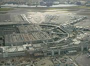
Miami International Airport
Miami International Airport
Miami International Airport , also known as MIA and historically Wilcox Field, is the primary airport serving the South Florida area...
, serves as the primary international airport of the Greater Miami Area. One of the busiest international airports in the world, Miami International Airport caters to over 35 million passengers a year. Identifiable locally, as well as several worldwide authorities, as MIA or KMIA, the airport is a major hub and the single largest international gateway for American Airlines
American Airlines
American Airlines, Inc. is the world's fourth-largest airline in passenger miles transported and operating revenues. American Airlines is a subsidiary of the AMR Corporation and is headquartered in Fort Worth, Texas adjacent to its largest hub at Dallas/Fort Worth International Airport...
, the world's second-largest passenger air carrier. Miami International is the busiest airport in Florida, and is the United States' second-largest international port of entry for foreign air passengers behind New York's John F. Kennedy International Airport
John F. Kennedy International Airport
John F. Kennedy International Airport is an international airport located in the borough of Queens in New York City, about southeast of Lower Manhattan. It is the busiest international air passenger gateway to the United States, handling more international traffic than any other airport in North...
, and is the seventh-largest such gateway in the world. The airport's extensive international route network includes non-stop flights to over seventy international cities in North and South America, Europe, Asia, and the Middle East.
The airport is served by taxis, dedicated Airport Express Metrobus routes, as well as several shuttle bus services available 24 hours a day. It also has a large rental car center and parking garage, known as the Miami Intermodal Center
Miami Intermodal Center
For the rail station next to the MIC, see Miami Central StationMiami Intermodal Center is a transportation hub under construction by the Florida Department of Transportation in Miami, Florida, in the United States. It will offer centralized transfer between Metrorail, Amtrak, Tri-Rail, buses,...
, and a rail station for Amtrak and Tri-Rail
Tri-Rail
Tri-Rail is a commuter rail line linking Miami, Fort Lauderdale, and West Palm Beach, Florida, United States. It is run by the South Florida Regional Transportation Authority. The system has 18 stations along the South Florida coast...
, known as Miami Central Station
Miami Central Station
Miami Central Station, also called Miami Airport Station, is a rapid transit, commuter rail, intercity rail, and intercity bus union station currently under construction in Miami, Florida, United States, in the Grapeland Heights neighborhood....
both of these centers are being completely rebuilt and in 2012 will be served by MIA Mover and Metrorail's AirportLink as well.
Two smaller, regional airports in Dade County are the Kendall-Tamiami Executive Airport
Kendall-Tamiami Executive Airport
Kendall-Tamiami Executive Airport is a public airport located in unincorporated Miami-Dade County, Florida, United States, 13 miles southwest of Downtown Miami....
and the Opa-Locka Airport
Opa-locka Airport
Opa-locka Airport , also known as Opa-locka Executive Airport, is a general aviation airport and joint civil-military airfield 10 miles north of Downtown Miami, primarily in metropolitan Miami, Florida, United States, with a portion within the city proper of Opa-locka.The airport's control tower...
.
MIA Mover
The MIA Mover is a new, free, automated people mover connecting the MIA Central Terminal of Miami International Airport to the new Miami Central StationMiami Central Station
Miami Central Station, also called Miami Airport Station, is a rapid transit, commuter rail, intercity rail, and intercity bus union station currently under construction in Miami, Florida, United States, in the Grapeland Heights neighborhood....
and Miami Intermodal Center
Miami Intermodal Center
For the rail station next to the MIC, see Miami Central StationMiami Intermodal Center is a transportation hub under construction by the Florida Department of Transportation in Miami, Florida, in the United States. It will offer centralized transfer between Metrorail, Amtrak, Tri-Rail, buses,...
, which are still under construction. MIA Mover opened on September 9, 2011 and is 1.27 miles long, running on an elevated track. MIA Mover has a top speed of over 40 miles per hour and the capacity to move more than 3,000 people per hour.
AirportLink (Metrorail)
AirportLink is the only completed phase of the MDT Orange Line. It connects the airport's new, under construction Miami Central StationMiami Central Station
Miami Central Station, also called Miami Airport Station, is a rapid transit, commuter rail, intercity rail, and intercity bus union station currently under construction in Miami, Florida, United States, in the Grapeland Heights neighborhood....
to the main Metrorail line at the Earlington Heights station. It consists of a 2.4 mile elevated line that is still under construction and will open in 2012.
Miami Central Station
Miami Central StationMiami Central Station
Miami Central Station, also called Miami Airport Station, is a rapid transit, commuter rail, intercity rail, and intercity bus union station currently under construction in Miami, Florida, United States, in the Grapeland Heights neighborhood....
is a major new transit hub that, along with the new Miami Intermodal Center
Miami Intermodal Center
For the rail station next to the MIC, see Miami Central StationMiami Intermodal Center is a transportation hub under construction by the Florida Department of Transportation in Miami, Florida, in the United States. It will offer centralized transfer between Metrorail, Amtrak, Tri-Rail, buses,...
, will connect and centralize all the major forms of transportation to and from Miami International Airport. MIA Mover, Metroail's AirportLink, Amtrak, Tri-Rail, Metrobus, the rental car centers, and personal vehicles will all come together there. Phase I for Metrobus, MIA Mover, AirportLink and cars is scheduled for completion in 2012, while Phase II for Amtrak and Tri-Rail is scheduled to be completed in mid 2013. Miami Central Station will serve as a connection point between all forms of ground transportation in South Florida, including walking and bicycling.
Fort Lauderdale - Hollywood International Airport
Located just to the north, in Broward County, is another large airport, Fort Lauderdale-Hollywood International AirportFort Lauderdale-Hollywood International Airport
Fort Lauderdale – Hollywood International Airport is an international commercial airport located in unincorporated Broward County, Florida, three miles southwest of the central business district of Fort Lauderdale...
(FLL).
Palm Beach International Airport
Palm Beach International AirportPalm Beach International Airport
Palm Beach International Airport is a public airport located 3 nautical miles west of Palm Beach, Florida, in West Palm Beach, Florida, and serves Palm Beach County. The airport is operated and maintained by Palm Beach County Department of Airports. Road access to the airport is available...
(PBI) is a public airport
Airport
An airport is a location where aircraft such as fixed-wing aircraft, helicopters, and blimps take off and land. Aircraft may be stored or maintained at an airport...
located 3 nautical miles (5.6 kilometers) west of Palm Beach, Florida
Palm Beach, Florida
The Town of Palm Beach is an incorporated town in Palm Beach County, Florida, United States. The Intracoastal Waterway separates it from the neighboring cities of West Palm Beach and Lake Worth...
, in West Palm Beach, Florida
West Palm Beach, Florida
West Palm Beach, is a city located on the Atlantic coast in southeastern Florida and is the most populous city in and county seat of Palm Beach County, the third most populous county in Florida with a 2010 population of 1,320,134. The city is also the oldest incorporated municipality in South Florida...
, and serves Palm Beach County
Palm Beach County, Florida
Palm Beach County is the largest county in the state of Florida in total area, and third in population. As of 2010, the county's estimated population was 1,320,134, making it the twenty-eighth most populous in the United States...
. The airport is operated and maintained by Palm Beach County Department of Airports. Road access to the airport is available directly from I-95
Interstate 95 in Florida
Interstate 95 is the main Interstate Highway on the east coast of the United States; it serves the Atlantic coast of Florida. It begins at a partial interchange with U.S. Highway 1 just south of downtown Miami, and heads north past Daytona Beach and Jacksonville to the Georgia state line at the St...
, Southern Boulevard, and Congress Avenue. The airport is bordered to the west by Military Trail.
Sea
The entire length of the South Florida metropolitan area is situated along the sea. Port of Miami in Miami-Dade and Port Everglades in Broward are South Florida's two major seaports, while Port of Palm BeachPort of Palm Beach
The Port of Palm Beach is located in Riviera Beach, Florida, in Palm Beach County. The Port is an independent taxing district, with a five-member board of commissioners elected at large by voters within the district. The Port district covers a land area of or approximately fifty percent of the...
is a smaller port located in Palm Beach County.
Port of Miami
The Dante B. Fascell Port of Miami is one of the busiest cruise ship ports in the world, as well as a major cargo port. Located right in downtown Miami, it is currently only accessible by car via a six lane bridge known as the Port Boulevard causeway, which terminates on the city streets of downtown. When the damaged tracks of the FEC freight line are repaired, Tri-Rail may run a passenger train service to the port. Additionally, to give the port direct interstate access and to help relieve downtown traffic, work is underway on a $1 billion tunnel project to connect the port to I-395 on Watson Island via the Port of Miami Tunnel, due to be complete in May 2014. Port EvergladesPort Everglades
Port Everglades is a port in Broward County, Florida. As one of South Florida's leading economic powerhouses, Port Everglades is the gateway for international trade and cruise vacations. Already one of the three busiest cruise ports worldwide, Port Everglades is also one of Florida's leading...
is another equally busy cruise and cargo port located near Fort Lauderdale in Broward County.
Port Everglades
Port Everglades, located in Fort Lauderdale in Broward County, is another major seaport that is about equally busy as Port of Miami in terms of cruise and cargo traffic. It is home to the two largest cruise ships in the world, Oasis of the Seas and Allure of the Seas.Other
In addition to the ports, South Florida has many marinas and navigable waterways for privately owned boats and yachts. The Miami RiverMiami River (Florida)
The Miami River is a river in the United States state of Florida that drains out of the Everglades and runs through the Downtown and the city of Miami. The long river flows from the terminus of the Miami Canal at Miami International Airport to Biscayne Bay...
, which travels right through downtown, is publicly accessible and leads to inland marinas. Miami Beach has a long, inland canal as well. Biscayne Bay
Biscayne Bay
Biscayne Bay is a lagoon that is approximately 35 miles long and up to 8 miles wide located on the Atlantic coast of South Florida, United States. It is usually divided for purposes of discussion and analysis into three parts: North Bay, Central Bay, and South Bay. Its area is...
is popular for fishing, sailing, and kayaking. There are also several recreational water taxi
Water taxi
A water taxi or water bus, also known as a commuter boat, is a watercraft used to provide public transport, usually but not always in an urban environment. Service may be scheduled with multiple stops, operating in a similar manner to a bus, or on demand to many locations, operating in a similar...
s that gives sightseeing tours along the coast.
Public transportation
Metrorail, Metrobus, and Metromover, all operated by Miami-Dade TransitMiami-Dade Transit
Miami-Dade Transit is the primary public transit authority of Miami, Florida, United States and the greater Miami-Dade County area. It is the largest transit system in Florida and the 12th-largest transit system in the United States....
, comprise the majority of public transportation options in Dade County. Miami-Dade Transit also runs the Paratransit division’s Special Transportation Service. The only public transportation systems currently offered in Broward and Palm Beach County are the bus systems, run by Broward County Transit
Broward County Transit
Broward County Transit is the public transit authority in Broward County, Florida. It is the second largest transit system in Florida. It currently operates the only public bus system in Broward County...
and Palm Tran
Palm Tran
Palm Tran is a bus system run by the Palm Beach County Government, serving Palm Beach County, Florida. Standard one-way fare is $1.50 . For $3.55 an unlimited all-day pass . There are no free transfers except to Tri-Rail or Broward County Transit...
, respectively. South Florida's tri-county commuter rail system, Tri-Rail
Tri-Rail
Tri-Rail is a commuter rail line linking Miami, Fort Lauderdale, and West Palm Beach, Florida, United States. It is run by the South Florida Regional Transportation Authority. The system has 18 stations along the South Florida coast...
, is operated by the South Florida Regional Transportation Authority
South Florida Regional Transportation Authority
The South Florida Regional Transportation Authority is a tri-county public transit authority operating out of Pompano Beach, Florida, serving Miami-Dade, Broward and Palm Beach counties. The organization was created on July 1, 2003 by the Florida Legislature and enacted by the Florida Department...
(SFRTA). There are also several localized public bus systems, such as the South Beach Local and the Coral Gables trolley. The elongated and sprawled layout of the South Florida metropolitan area complicates the process of designing practical mass transit systems unlike more circular metros such as Boston
Boston
Boston is the capital of and largest city in Massachusetts, and is one of the oldest cities in the United States. The largest city in New England, Boston is regarded as the unofficial "Capital of New England" for its economic and cultural impact on the entire New England region. The city proper had...
and Washington DC which use traditional loops with radii spurs for their public transit and highway systems, known as the spoke-hub distribution paradigm
Spoke-hub distribution paradigm
The hub-and-spoke distribution paradigm is a system of connections arranged like a chariot wheel, in which all traffic moves along spokes connected to the hub at the center...
. Miami's existing Green Line and proposed Orange Line would only form the spokes, which could only emanate towards the west due to Miami's coastal location. Additionally, Miami is a relatively young city that saw much of its growth during the automobile age, and continues to be very car oriented. South Florida ranked fourth in the nation in a 2000 study of metro areas by the Washington-based Surface Transportation Policy Project for percentage of household income spent on transportation, with an average of 19%. Many of the downtown high rises have their own very large, above ground parking garages located at the bottom. The entire urbanized South Florida metropolitan area
South Florida metropolitan area
The South Florida metropolitan area, also known as the Miami metropolitan area, and designated the Miami–Fort Lauderdale–Pompano Beach, FL Metropolitan Statistical Area by the U.S...
, being about 110 miles long but no more than 20 miles wide in any part, as well as covering three counties, further complicated the creation of a unified transit solution. As of the 2000 census, it was the eighth most densely populated metropolitan area in the United States, with the city of Miami growing at about a 10% growth rate.
Metrorail
Metrorail is a heavy rail rapid transit system comprising a single 22.4 mile line, known as the Green Line, with 22 stations. Starting in Hialeah, it travels generally southeast to the CBD and Brickell, then travels generally southwest to KendallKendall, Florida
Kendall is a suburban neighborhood of metropolitan Miami, Florida, United States. As of the 2000 census, the area had a total population of 75,226....
. It has been in operation since 1984. In the 1970s, there was a plan to fund several more highways in South Florida, but it was decided by the people that a mass transit option was more desirable. It was intended that the existing line would only be the beginning, hence many more were planned. However, due to budget shortfalls and less than anticipated ridership, none other than the 2.4 mile AirportLink have been realized. When completed in 2012, it will connect to Metrorail's 23rd station at Miami Central Station
Miami Central Station
Miami Central Station, also called Miami Airport Station, is a rapid transit, commuter rail, intercity rail, and intercity bus union station currently under construction in Miami, Florida, United States, in the Grapeland Heights neighborhood....
.
The current standard fare on Metrorail is $2 and reduced fare is $1. A standard monthly pass
Season ticket
A season ticket is a ticket that grants privileges over a defined period of time.-Sport:In sport, a season ticket grants the holder access to all regular-season home games for one season without additional charges. The ticket usually offers a discounted price over purchasing a ticket for each of...
costs $100 and $50 for reduced fare. The monthly EASY Cards are sold at over 50 sales outlets. Reduced fares are available only to Medicare
Medicare (United States)
Medicare is a social insurance program administered by the United States government, providing health insurance coverage to people who are aged 65 and over; to those who are under 65 and are permanently physically disabled or who have a congenital physical disability; or to those who meet other...
recipients, people with disabilities
Disability
A disability may be physical, cognitive, mental, sensory, emotional, developmental or some combination of these.Many people would rather be referred to as a person with a disability instead of handicapped...
, and Miami-Dade students in grades 1-12. Ticket Vending Machines (TVMs)
Ticket machine
A ticket machine, also known as a ticket vending machine , is a vending machine that produces tickets. For instance, ticket machines dispense train tickets at railway stations and tram tickets at some tram stops and in some trams...
that sell EASY Cards and EASY Tickets are found in all rail stations. All Miami-Dade senior citizen
Senior citizen
Senior citizen is a common polite designation for an elderly person in both UK and US English, and it implies or means that the person is retired. This in turn implies or in fact means that the person is over the retirement age, which varies according to country. Synonyms include pensioner in UK...
s aged 65 years and older and with Social Security
Social Security (United States)
In the United States, Social Security refers to the federal Old-Age, Survivors, and Disability Insurance program.The original Social Security Act and the current version of the Act, as amended encompass several social welfare and social insurance programs...
benefits, and Veteran
Veteran
A veteran is a person who has had long service or experience in a particular occupation or field; " A veteran of ..."...
s residing in Miami-Dade and earning less than $22,000 annually ride free with the reduced fare monthly EASY Card.
On July 16, 2008, Miami-Dade Transit announced that it would be replacing all fare collection methods with the EASY Card
EASY Card (South Florida)
The EASY Card system is a series of linked contactless smartcard systems used by Miami-Dade Transit and South Florida Regional Transportation Authority in the South Florida, Florida, United States area. The EASY Card allows for electronic payment on multiple public transport systems including Miami...
system by late 2009. The system replaces the old cash-/token-based system with one that automatically deducts fares at Metrorail fare gates from a reloadable card. The final station to start fare gate installation was Government Center on August 2, 2009. Since the system launch on October 1, 2009, all passengers utilizing Metrorail must use either an EASY Card or EASY Ticket to enter stations.
Metrorail runs from 5 a.m. until midnight
Midnight
Midnight is the transition time period from one day to the next: the moment when the date changes. In the Roman time system, midnight was halfway between sunset and sunrise, varying according to the seasons....
seven days a week. Trains arrive every 8 minutes during weekday rush hour
Rush hour
A rush hour or peak hour is a part of the day during which traffic congestion on roads and crowding on public transport is at its highest. Normally, this happens twice a day—once in the morning and once in the evening, the times during when the most people commute...
s, every 15 minutes at midday
Noon
Noon is usually defined as 12 o'clock in the daytime. The word noon is also used informally to mean midday regarding the location of the sun not the middle of a persons day. Although this is a time around the middle of the day when people in many countries take a lunch break...
, and every 30 minutes after 7:30 p.m. until closing at midnight. Weekend
Workweek
The workweek and weekend are those complementary parts of the week devoted to labour and rest respectively. The legal working week , or workweek , is the part of the seven-day week devoted to labor. In most Western countries it is Monday to Friday. The weekend comprises the two traditionally...
service runs every 30 minutes until midnight. For a brief period from 2003 to April 2004 there was 24-hour service; between midnight and 5 a.m., trains arrived every 60 minutes. 16 of the 22 stations have dedicated parking facilities, either a garage or a surface lot, with a charge of $4 a day. The stops that don't are Tri-Rail and the five "downtown" stations, Civic Center, Culmer, Historic Overton/Lyric Theater, Government Center, and Brickell. However, there are multiple parking garages available around these stops.
A limited-stop
Limited-stop
In public transport, a limited-stop bus, tram or train service is a service that operates along the same route as a local bus service, but omits certain stops in order to offer a faster trip between the places served. The term is normally used on routes with a mixture of fast and slow services...
bus route, Route 500 Midnight Owl, operates hourly between 12:30 a.m. and 5:30 a.m. trip between Dadeland South and Government Center Metrorail stations. This bus service replaces the 24-hour Metrorail service cancelled due to a lack of ridership.
Construction on the first segment of the Orange Line, Metrorail's AirportLink began in June 2009; service to Miami International Airport
Miami International Airport
Miami International Airport , also known as MIA and historically Wilcox Field, is the primary airport serving the South Florida area...
is scheduled to begin in spring 2012
2012 in rail transport
- Events : 14 January – Construction is expected to be completed on the Marina Bay Extension of the Circle MRT Line. 31 January – First Group/Keolis' First TransPennine Express franchise, First TransPennine Express, expires 4 February – National Express's East Anglia franchise expires 31 March –...
.
The Miami-Dade County Government is working with the Citizens Independent Transportation Trust to receive money from the half-penny sur-tax approved by voters in 2002 in order to purchase new Metrorail cars.
Metromover
Metromover is a free, automated people mover that operates on three loops totaling 4.4 miles of track and 22 stations in the central business district and Brickell. The main Inner Loop opened in 1986, and the Omni (north) and Brickell (south) extensions opened in 1994. The Metromover gained popularity significantly when the 25 cent fare was lifted in 2002. Since then it has been free to ride. Metromover is used heavily by those who live and work in downtown, with ridership doubling from 2000 to 2011, as well as by tourists staying in downtown to get to attractions or just to get a free tour of the downtown cityscape. It is also used by those who commute into the city using Metrorail and Tri-Rail. Metrorail and Metromover are connected at the Government Center and Brickell stations. Tri-Rail and Metrorail are connected at the Tri-Rail and Metrorail transfer stationTri-Rail and Metrorail transfer station
Tri-Rail and Metrorail Transfer Station is a Metrorail and Tri-Rail interchange station in Hialeah, Florida, in metropolitan Miami.This station is located near the intersection of East 25th Street and 11th Avenue, officially opening to service March 6, 1989. The station was built as a connection...
.
Stations
The Metromover currently operates 22 stations, and combined with the Metrorail, the entire Metro system operates 44 stations. Metrorail stations are located at about a mile apart along the line, and Metromover stations are located at approximately every two blocks in the greater Downtown MiamiDowntown Miami
Downtown Miami is an urban residential neighborhood, and the central business district of Miami, Miami-Dade County, and South Florida in the United States...
area.
Currently all stations, except for Knight Center station located in the bottom of the Miami Tower and Government Center station
Government Center Station
Government Center Station could refer to:* Government Center , serving Government Center, Boston, Massachusetts* Government Center , the main rail station of Downtown Miami, Florida...
located at the bottom of the Stephen P. Clark Government Center
Stephen P. Clark Government Center
The Stephen P. Clark Government Center, known also as Government Center, Miami-Dade Center, or County Hall, is a skyscraper in the Government Center district of Downtown Miami, Florida, United States. It is the headquarters building of the Miami-Dade County government. Many county offices are...
, are stand alone units with no direct integration with other developments. The platforms are elevated and most have functioning elevators and escalators (usually only for up), as well as stairs, to access them. For the future, however, there are at least two large developments that plan to incorporate the Metromover into their design. One is Brickell CitiCentre, located in the Brickell financial district on the south side of downtown, which will integrate the Eighth Street Metromover Station. Another is Resorts World Miami
Resorts World Miami
Resorts World Miami is the name of a 13.9 acre major development proposed for the Omni District of Downtown Miami by the Malaysian based Genting Group. At 10 million square feet and with an estimated cost of $3.1 billion, it is considered one of the largest developments in the history of Florida...
, planned for the Omni district north of downtown, which plans to modify the Metromover line where it passes the to be demolished Miami Herald building, as well as building a new station into its development. Two other high-rise projects have also claimed a Metromover integration, the cancelled Brickell Flatiron
Brickell Flatiron
The Brickell Flatiron was a planned skyscraper in downtown Miami, Florida. It had been approved by the City of Miami was construction is expected to begin in 2008, but the building was put on hold or cancelled...
building, which would have had a hole for the line to pass through it, and the proposed One Bayfront Plaza
One Bayfront Plaza
One Bayfront Plaza is a skyscraper approved for construction in the U.S. city of Miami, Florida. If completed, the building would stand at , with 80 floors. One Bayfront Plaza would primarily consist of offices and hotel space, but also would include a retail mall and parking garage on the lower...
skyscraper, whose original, as well as its latest known designs are planned to have a pedestrian bridge connecting it to the Bayfront Park Metromover station. As far as expansion, an extension to the Port of Miami and then to South Beach has been considered among others, but none have yet made it beyond preliminary planning and impact study stage.
Metrobus
The Metrobus network provides bus service throughout Miami-Dade CountyMiami-Dade County, Florida
Miami-Dade County is a county located in the southeastern part of the state of Florida. As of 2010 U.S. Census, the county had a population of 2,496,435, making it the most populous county in Florida and the eighth-most populous county in the United States...
365 days a year. It consists of more than 100 routes and 900 buses, which connect most points in the county and part of southern Broward County
Broward County, Florida
-2000 Census:As of the census of 2000, there were 1,623,018 people, 654,445 households, and 411,645 families residing in the county. The population density was 1,346 people per square mile . There were 741,043 housing units at an average density of 615 per square mile...
as well, to connect with the Broward County Transit
Broward County Transit
Broward County Transit is the public transit authority in Broward County, Florida. It is the second largest transit system in Florida. It currently operates the only public bus system in Broward County...
bus system. Standard fare is $2. Seven of these routes operate around the clock: Routes 3, 11, 27, 38, 77, L (No 24 hour Hialeah service) and S. Routes 246 Night Owl & Route 500 Midnight Owl operate from 12am to 5am. Most other routes operate from 5 AM to 11 PM. All Metrobuses are wheelchair accessible, in compliance with the Americans with Disabilities Act of 1990
Americans with Disabilities Act of 1990
The Americans with Disabilities Act of 1990 is a law that was enacted by the U.S. Congress in 1990. It was signed into law on July 26, 1990, by President George H. W. Bush, and later amended with changes effective January 1, 2009....
.
Bus route 301 (Dade-Monroe Express) extends into Monroe County
Monroe County, Florida
Monroe County is a county located in the state of Florida. As of 2000, the population was 79,589. The U.S. Census Bureau 2006 estimate for the county was 74,737....
, reaching Marathon
Marathon, Florida
Marathon is a city on Knight's Key, Boot Key, Key Vaca, Fat Deer Key, Long Point Key, Crawl Key and Grassy Key islands in the middle Florida Keys, in Monroe County, Florida, in the United States. As of the 2000 census, the city had a total population of 10,255. As of 2005, the population estimated...
, where a transfer is available to a Key West Transit bus proceeding further into the Keys. With the appropriate bus transfers, one can travel all the way from Key West
Key West, Florida
Key West is a city in Monroe County, Florida, United States. The city encompasses the island of Key West, the part of Stock Island north of U.S. 1 , Sigsbee Park , Fleming Key , and Sunset Key...
to Jupiter
Jupiter, Florida
Jupiter is a town located in Palm Beach County, Florida. As of the 2000 census, the town had a total population of 39,328. The estimate population for 2009 is 50,606. As of 2006, the population had grown to 50,028, according to the University of Florida, Bureau of Economic and Business Research....
entirely on public-transit buses.
South Miami-Dade Busway
The South Miami-Dade Busway (originally the South Dade BuswayBusway
Busway may refer to several things:Transport technology* Bus rapid transit, bus systems including some elements of trams or metro systems* Guided busway, concrete tracks exclusively for modified busesTransport systems...
) began operating on February 3, 1997 and was extended in April 2005. The final 6.5 miles (10.5 km) segment of the Busway extension to Florida City opened on Sunday, December 16, 2007. It is an exclusive bus road that runs parallel to US1/ S Dixie Highway, and replaced an abandoned Florida East Coast Railroad line. It functions effectively as an extension of the Metrorail line and is an alternative to daily traffic congestion. The 13 miles (20.9 km) roadway was built by the Florida Department of Transportation
Florida Department of Transportation
The Florida Department of Transportation is a decentralized agency charged with the establishment, maintenance, and regulation of public transportation in the state of Florida. The department was formed in 1969. It absorbed the powers of the Florida State Road Department...
just for Metrobus routes and emergency vehicles. Express buses on the exclusive lanes shuttle passengers to and from Dadeland South Station
Dadeland South (Metrorail station)
Dadeland South is a Metrorail transfer station in the Miami suburb of Kendall, Florida at Dadeland. It is the southern terminus of the metro system....
(see Metrorail) in under 40 minutes.
Both full-size buses and minibuses operate on the Busway and in adjacent neighborhoods, entering the exclusive lanes at major intersections. Local and limited-stop service is offered between Florida City
Florida City, Florida
Florida City is a city in Miami-Dade County, Florida, United States and is the southernmost municipality in the South Florida metropolitan area, which had an estimated population of 5,413,212 in 2007. The population was 7,843 at the 2000 census. As of 2004, the population estimated by the U.S....
and Dadeland South Metrorail Station. Park & Ride
Park and ride
Park and ride facilities are car parks with connections to public transport that allow commuters and other people wishing to travel into city centres to leave their vehicles and transfer to a bus, rail system , or carpool for the rest of their trip...
lots along the busway are located at SW 152d Street (Coral Reef Drive), SW 168th Street (Richmond Drive), SW 200th Street (Caribbean Boulevard), SW 244th Street, and SW 296th Street. At Dadeland South Station
Dadeland South (Metrorail station)
Dadeland South is a Metrorail transfer station in the Miami suburb of Kendall, Florida at Dadeland. It is the southern terminus of the metro system....
, riders transfer to Metrorail. Riders headed downtown can transfer from Metrorail to Metromover, which consists of three shorter downtown loops, at Government Center Station
Government Center (changeover station)
Government Center is a Metrorail and Metromover rapid transit transfer station in Downtown, Miami, Florida, United States.It is the hub of most travel via Miami-Dade Transit , servicing the two metros, Metrobus, and Paratransit...
.
The South Miami-Dade Busway features 28 stops, all of which have been converted to light-rail style stations. A multi-use path
Segregated cycle facilities
Segregated cycle facilities are marked lanes, tracks, shoulders and paths designated for use by cyclists from which motorised traffic is generally excluded...
stretches the length of the Busway.
Routes that use the Busway
- 31 Busway Local- serves all stations between northern end of the busway and Southland MallSouthland Mall (Miami, Florida)Southland Mall, originally known as Cutler Ridge Mall, is a shopping mall in Cutler Bay , Florida. It opened in 1978 as an extension of the Cutler Ridge Shopping Center, which itself was opened in 1960...
, before looping to serve Cutler BayCutler Bay, FloridaCutler Bay, historically called Cutler Ridge, is an incorporated town in Miami-Dade County, Florida from SW 184th Street east of US-1 to the coast, and north of Black Point Marina, at...
shopping centers and the South Dade Government Office Complex - 34 Busway Flyer- travels the entire length of the busway, but does not stop at any stations before SW 152nd Street
- 38 Busway MAX- travels the entire length of the busway, deviating from the route slightly to serve Southland Mall, and travelling beyond the end of the busway to serve Florida City shopping centers
- 52- begins at Dadeland North Metrorail StationDadeland North (Metrorail station)Dadeland North is a Metrorail station in Miami, Florida in the suburb of Kendall.This station is located at the intersection of South Dixie Highway and Southwest 83rd Street on the Snapper Creek, near the Snapper Creek Expressway...
, then runs along busway to SW 152nd street, before becoming a Richmond Heights and Goulds local route - 252 Coral Reef MAX- begins at Dadeland South Metrorail StationDadeland South (Metrorail station)Dadeland South is a Metrorail transfer station in the Miami suburb of Kendall, Florida at Dadeland. It is the southern terminus of the metro system....
, then runs along busway to SW 152nd Street, before becoming express route to Country WalkCountry Walk, FloridaCountry Walk is a census-designated place Miami suburb in Miami-Dade County, Florida, United States. The population was 15,997 at the 2010 census.-Geography:Country Walk is located at .... - 287 Saga Bay MAX- begins at Dadeland South Metrorail Station, then runs along busway to SW 168th Street, before running as express route through West PerrineWest Perrine, FloridaWest Perrine is a census-designated place in Miami-Dade County, Florida, United States. Prior to the 2000 census it was part of Perrine. The other part of Perrine became the East Perrine CDP for the 2000 census and is now part of the incorporated Village of Palmetto Bay...
and Saga Bay
Busway vs. rail controversy
The Busway has been the site of many accidents, as some car drivers driving south on US-1 (which runs parallel to the Busway for much of its length), and looking to turn west, do not stop at the red arrows that govern the right turn lane at an intersection that has a Busway crossing adjacent to it. They make a right turn and go right into the path of a bus that is entering the adjacent Busway intersection. Buses currently have to slow down to 15 mi/h before crossing the intersection, and the police often patrol the intersections looking for red arrow runners. Surprisingly, even the intersections where the Busway runs as far as 2 blocks west of US-1 suffer the same problem, with car drivers either not seeing or flatly ignoring the red lights at SW 184th and 186th Streets. City planners and residents alike have commented that rather than dismantling the former Florida East Coast Railroad line for the busway, the Metrorail system could have been extended southward over the railway line.Broward County Transit
Broward County TransitBroward County Transit
Broward County Transit is the public transit authority in Broward County, Florida. It is the second largest transit system in Florida. It currently operates the only public bus system in Broward County...
(BCT) is the public transit authority in Broward County
Broward County, Florida
-2000 Census:As of the census of 2000, there were 1,623,018 people, 654,445 households, and 411,645 families residing in the county. The population density was 1,346 people per square mile . There were 741,043 housing units at an average density of 615 per square mile...
, operating a county-wide bus system covering the greater Fort Lauderdale area. It is the second largest transit system in Florida (after Miami-Dade Transit). It currently operates the only public bus system in Broward County. Besides serving Broward County, it also serves portions of Palm Beach County and Miami-Dade County where the systems share transit hubs such as Aventura Mall
Aventura Mall
The Aventura Mall is an upscale super-regional shopping mall in Aventura, Florida, a northern suburb of Miami. It is the largest conventional shopping mall in Florida, having a gross leasable area of , and is the fifth largest shopping center in the United States. The mall has three floors of...
in Miami-Dade County.
Palm Tran
Palm TranPalm Tran
Palm Tran is a bus system run by the Palm Beach County Government, serving Palm Beach County, Florida. Standard one-way fare is $1.50 . For $3.55 an unlimited all-day pass . There are no free transfers except to Tri-Rail or Broward County Transit...
is a bus system run by the Palm Beach County Government, serving Palm Beach County
Palm Beach County, Florida
Palm Beach County is the largest county in the state of Florida in total area, and third in population. As of 2010, the county's estimated population was 1,320,134, making it the twenty-eighth most populous in the United States...
. Standard (Adult) one-way fare is $1.50 (people eligible for the reduced fare such as students and senior citizens pay $0.75). For $3.55 an unlimited all-day pass ($2.25 for reduced fare). There are no free transfers except to Tri-Rail
Tri-Rail
Tri-Rail is a commuter rail line linking Miami, Fort Lauderdale, and West Palm Beach, Florida, United States. It is run by the South Florida Regional Transportation Authority. The system has 18 stations along the South Florida coast...
or Broward County Transit
Broward County Transit
Broward County Transit is the public transit authority in Broward County, Florida. It is the second largest transit system in Florida. It currently operates the only public bus system in Broward County...
. Daily and 31-day unlimited ride passes are also available for purchase. There are 31-day unlimited passes that are available reduced or regular costing $55 and $40 respectively. All Palm Tran buses have bicycle racks
Bicycle carrier
A bicycle carrier, also commonly called a bike rack, is a device attached to an automobile or bus for transporting bicycles.- By vehicle type :Bus mounted bike carriers are usually attached to the front of the bus...
on the front, capable of holding two bikes.
Other buses
South BeachSouth Beach
South Beach, also nicknamed SoBe, is a neighborhood in the city of Miami Beach, Florida, United States. It is the area south of Indian Creek and encompasses roughly the southernmost 23 blocks of the main barrier island that separates the Atlantic Ocean and Biscayne Bay.This area was the first...
operates its own local bus system known as the South Beach Local. The fare is only 25 cents. Trolley streetcars have been proposed for areas like downtown and Coral Gables. Since it began operation in 2003, the free Coral Gables Trolley (bus) has moved over four million commuters around downtown Coral Gables with over 5,000 riders per day, freeing up 750 local parking spaces and reducing car trips by 20% along its route. The city of Hollywood
Hollywood, Florida
-Demographics:As of 2000, there were 59,673 households out of which 24.9% had children under the age of 18 living with them, 41.5% were married couples living together, 11.9% had a female householder with no husband present, and 42.2% were non-families. 34.4% of all households were made up of...
operates a trolley route serving its downtown area and Hollywood Beach.
Rail
Miami-Dade County is located at the southern end of two prominent rail lines, the state-owned CSX passenger line, and the Florida East Coast RailwayFlorida East Coast Railway
The Florida East Coast Railway is a Class II railroad operating in the U.S. state of Florida; in the past, it has been a Class I railroad.Built primarily in the last quarter of the 19th century and the first decade of the 20th century, the FEC was a project of Standard Oil principal Henry Morrison...
freight line. It also has a regional commuter rail system (Tri-Rail), which uses the CSX line, and was planned to be connected to Orlando
Orlando
Orlando is a major city in the U.S. state of Florida.Orlando may also refer to-Places:* in Florida** Orlando, a major city** Greater Orlando, the 27th-largest metropolitan area in the United States...
and Tampa
Tâmpa
Tâmpa may refer to several villages in Romania:* Tâmpa, a village in Băcia Commune, Hunedoara County* Tâmpa, a village in Miercurea Nirajului, Mureş County* Tâmpa, a mountain in Braşov city...
by a high-speed rail
High-speed rail in the United States
High-speed rail in the United States currently consists of one high-speed rail service: Amtrak's Acela Express runs on the Northeast Corridor from Boston to Washington, D.C...
system; however that plan was cancelled in 2011. Historically, the Florida East Coast Railway
Florida East Coast Railway
The Florida East Coast Railway is a Class II railroad operating in the U.S. state of Florida; in the past, it has been a Class I railroad.Built primarily in the last quarter of the 19th century and the first decade of the 20th century, the FEC was a project of Standard Oil principal Henry Morrison...
(FEC) line went all the way to Key West
Key West
Key West is an island in the Straits of Florida on the North American continent at the southernmost tip of the Florida Keys. Key West is home to the southernmost point in the Continental United States; the island is about from Cuba....
running passenger and freight service. However, the Overseas Railroad
Overseas Railroad
The Overseas Railroad was an extension of the Florida East Coast Railway to Key West, a city of almost 30,000 inhabitants located 128 miles beyond the end of the Florida peninsula...
through the Keys was severely damaged during the 1935 Labor Day hurricane and service never returned.
Tri-Rail
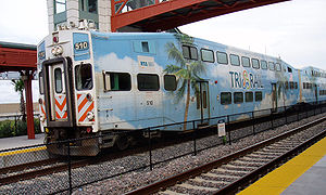
South Florida Regional Transportation Authority
The South Florida Regional Transportation Authority is a tri-county public transit authority operating out of Pompano Beach, Florida, serving Miami-Dade, Broward and Palm Beach counties. The organization was created on July 1, 2003 by the Florida Legislature and enacted by the Florida Department...
(SFRTA) that runs north-south through Palm Beach, Broward, and Dade county, terminating at Miami International Airport in Dade County. Tri-Rail is split into six zones. Fare ranges from $2.50 to $11.55 and is determined by the number of zones travelled through and one way or round trip. A standard fare of $100 for a month is also available. Many Tri-Rail stations have free parking.
Tri-Rail may relocate or add service to a more easterly alignment on the Florida East Coast Railway
Florida East Coast Railway
The Florida East Coast Railway is a Class II railroad operating in the U.S. state of Florida; in the past, it has been a Class I railroad.Built primarily in the last quarter of the 19th century and the first decade of the 20th century, the FEC was a project of Standard Oil principal Henry Morrison...
freight line, which would bring it closer to the major population centers of South Florida, of which he FEC line passes through about 22. This would also bring it directly into Downtown Miami, where it would terminate at the Government Center transit hub, and might possibly even have a spur to the Port of Miami
Port of Miami
The Dante B. Fascell Port of Miami is a seaport located in Biscayne Bay in Miami, Florida, United States. It is connected to Downtown Miami by Port Boulevard, a bridge over the Intracoastal Waterway. The port is located on Dodge Island, which is the combination of three historic islands that have...
. This would also extend service northward to Jupiter
Jupiter, Florida
Jupiter is a town located in Palm Beach County, Florida. As of the 2000 census, the town had a total population of 39,328. The estimate population for 2009 is 50,606. As of 2006, the population had grown to 50,028, according to the University of Florida, Bureau of Economic and Business Research....
, which would more than double Tri-Rail's current system length. Currently, Tri-Rail is a phenomenal money loser and relies heavily on shuttle buses and parking at stations because they are not within many people's walking distance. To save money, the state is looking to bid out Tri-Rail operations to a private organization such as the Florida Department of Transportation, which would likely own and operate the trains running on the FEC line. Other private companies may operate trains on the current line if the entire system is privatized, and an east-west connection could be made between the two, giving South Florida a more complete commuter rail system. The MIA station at the southern terminus of the current line will be closed for about two years from 2011 to 2013 while work is underway on the new Miami Central Station
Miami Central Station
Miami Central Station, also called Miami Airport Station, is a rapid transit, commuter rail, intercity rail, and intercity bus union station currently under construction in Miami, Florida, United States, in the Grapeland Heights neighborhood....
.
Amtrak
Miami is the southern terminus of AmtrakAmtrak
The National Railroad Passenger Corporation, doing business as Amtrak , is a government-owned corporation that was organized on May 1, 1971, to provide intercity passenger train service in the United States. "Amtrak" is a portmanteau of the words "America" and "track". It is headquartered at Union...
's Atlantic Coast services, running two lines, the Silver Meteor
Silver Meteor
The Silver Meteor is a 1389-mile passenger train route operated by Amtrak in the Silver Service brand, running from New York City, New York, south to Miami, Florida, via the Northeast Corridor to Washington, D.C., thence via Richmond, Virginia; Fayetteville, North Carolina; North Charleston, South...
and the Silver Star, both terminating in New York City. The Miami Amtrak Station is located in the suburb of Hialeah near the Tri-Rail/Metrorail Station
Tri-Rail and Metrorail transfer station
Tri-Rail and Metrorail Transfer Station is a Metrorail and Tri-Rail interchange station in Hialeah, Florida, in metropolitan Miami.This station is located near the intersection of East 25th Street and 11th Avenue, officially opening to service March 6, 1989. The station was built as a connection...
on NW 79 St and NW 38 Ave. Current construction of the Miami Central Station
Miami Central Station
Miami Central Station, also called Miami Airport Station, is a rapid transit, commuter rail, intercity rail, and intercity bus union station currently under construction in Miami, Florida, United States, in the Grapeland Heights neighborhood....
will move all Amtrak operations from its current out-of-the-way location to a centralized location with Metrorail, MIA Mover
MIA Mover
The MIA Mover is an automated people mover system which opened at the Miami International Airport in metropolitan Miami, Florida, United States on September 09th, 2011...
, Tri-Rail
Tri-Rail
Tri-Rail is a commuter rail line linking Miami, Fort Lauderdale, and West Palm Beach, Florida, United States. It is run by the South Florida Regional Transportation Authority. The system has 18 stations along the South Florida coast...
, Miami International Airport
Miami International Airport
Miami International Airport , also known as MIA and historically Wilcox Field, is the primary airport serving the South Florida area...
, and the Miami Intermodal Center
Miami Intermodal Center
For the rail station next to the MIC, see Miami Central StationMiami Intermodal Center is a transportation hub under construction by the Florida Department of Transportation in Miami, Florida, in the United States. It will offer centralized transfer between Metrorail, Amtrak, Tri-Rail, buses,...
all within the same station closer to Downtown. The station is expected to be completed by 2012.
Florida high-speed rail
Twice a Florida High Speed RailFlorida High Speed Rail
Florida High Speed Rail was a proposed high-speed rail project in the U.S. state of Florida. Initial service would have run between the cities of Tampa and Orlando, with plans to then extend service to South Florida, terminating in Miami. Trains with a top speed of to would have run on dedicated...
system was proposed to connect Miami with Orlando
Orlando
Orlando is a major city in the U.S. state of Florida.Orlando may also refer to-Places:* in Florida** Orlando, a major city** Greater Orlando, the 27th-largest metropolitan area in the United States...
and Tampa
Tampa Bay
Tampa Bay is a large natural harbor and estuary along the Gulf of Mexico on the west central coast of Florida, comprising Hillsborough Bay, Old Tampa Bay, Middle Tampa Bay, and Lower Tampa Bay."Tampa Bay" is not the name of any municipality...
. First in 2000, which was opposed by then Florida governor Jeb Bush
Jeb Bush
John Ellis "Jeb" Bush is an American politician who served as the 43rd Governor of Florida from 1999 to 2007. He is a prominent member of the Bush family: the second son of former President George H. W. Bush and former First Lady Barbara Bush; the younger brother of former President George W...
, then in 2009 the plan was revived with a grant offered under Obama's American Reinvestment and Recovery Act. However, Florida governor Rick Scott denied the funding in 2011, citing that it was still a risk due to uncertain ridership estimates and actual construction and maintenance costs, which could have been a burden to taxpayers. Many were disappointed in Scott's harebrained denial of the money. 26 Florida senators from both political parties signed a letter to United States Secretary of Transportation
United States Secretary of Transportation
The United States Secretary of Transportation is the head of the United States Department of Transportation, a member of the President's Cabinet, and fourteenth in the Presidential line of succession. The post was created with the formation of the Department of Transportation on October 15, 1966,...
Ray LaHood
Ray LaHood
Raymond H. "Ray" LaHood is a Republican politician from Illinois who is currently the United States Secretary of Transportation, having served since 2009. Previously, he represented the Illinois's 18th congressional district in the U.S. House of Representatives for seven terms .-Early life and...
encouraging him to ignore Scott's decision, and even former governor Jeb Bush, who was against the previous high-speed rail proposal, was surprised by Scott's actions. The money was ultimately directed to other states and the plan killed.
Bicycling
There are many popular bike routes in Dade County and South Florida. In recent years, the city government under Mayor Manny Diaz, has taken an ambitious stance in support of bicycling in Miami for both recreation and commuting. Every month, the city hosts "Bike Miami", where major streets in Downtown and Brickell are closed to automobiles, and left open for pedestrians and bicyclists. The event began in November 2008, and has doubled in popularity from 1,500 participants to about 3,000 in the October 2009 Bike Miami. This is the longest running such event in the U.S. Now known as Critical MassCritical Mass
Critical Mass is a cycling event typically held on the last Friday of every month in over 300 cities around the world. The ride was originally founded in 1992 in San Francisco. The purpose of Critical Mass is not usually formalized beyond the direct action of meeting at a set location and time and...
Miami, the event is held on the last Friday evening of every month. In October 2009, the city also approved an extensive 20-year plan for bike routes and paths around the city. The city has begun construction of bike routes as of late 2009, and under the new Miami 21 zoning laws ordinances requiring bike parking in all future construction in the city is now mandatory as of October 2009. In 2010, Miami was ranked No.44 most bike-friendly city in the U.S. according to Bicycling Magazine. Several large biking events are planned throughout South Florida for the fall 2011 season, including possible 100+ mile charity and timed runs.
In recent years, bicycling has grown in popular in Miami Beach, as well. Due to its dense, urban nature, and pedestrian-friendly streets, many Miami Beach residents get around by bicycle. Locally, South Beach has implemented many BikeShare units all around the neighborhood as well as the DecoBike system, which launched in March 2011. The initial rollout of the program included "approximately 100 solar-powered stations and 1,000 custom-designed bikes available to residents and visitors." This public bicycle sharing and rental program is owned and operated by DecoBike, LLC, a Miami-based company, and operates under a long-term agreement with the City of Miami Beach. The service is available to both residents and visitors - any adult with a major credit card can check out a bike to pedal to their next location. An iPhone app and an interactive map on the DecoBike website allows you to locate the nearest "station" and gives you the number of bikes available and the number of free docking spaces in real-time.
Walkability
A 2011 survey of the largest cities in the United States by walkscore.comWalkscore.com
Walk Score is a large-scale, public access walkability index that assigns a numerical walkability score to any address in the Australia, Canada, United States and New Zealand.. Other services include a transit score and an apartment search that locates potential residences based on commute time...
determined the City of Miami to be ranked eighth in terms of walkability. The ranking is based on proximity of restaurants, food, transit stops, and entertainment, among other things. Despite this, Miami, along with many younger, auto-dependent southern and western (Sunbelt) cities, is consistently ranked as one of the most dangerous cities in the US for pedestrians due to rude drivers, very wide roads, and the number of hit and runs. In 2002, pedestrians in Tampa-Orlando and Miami-Fort Lauderdale were found to be three times more likely to die than pedestrians in Cincinnati, Cleveland, and Columbus, Ohio. In 2011, all four of the most dangerous metropolitan areas or pedestrians in the United States were in Florida, with Miami-Fort Lauderdale coming in fourth. As the population grows in the Miami area, graded and textured crosswalks are added to slow traffic along busy streets such as Brickell and Biscayne Boulevard (US-1). New crosswalks installed in the Upper Eastside
Upper Eastside
The Upper East Side neighborhood in Miami, Florida, United States. It is north of Edgewater, east of Little Haiti, south of the village of Miami Shores, and sits on Biscayne Bay...
along Biscayne Boulevard in late 2011 will also be outlined with flashing lights, as well as having islands in the center of the road and large speed feedback signs to warn automotive traffic.
South Beach
South Beach
South Beach, also nicknamed SoBe, is a neighborhood in the city of Miami Beach, Florida, United States. It is the area south of Indian Creek and encompasses roughly the southernmost 23 blocks of the main barrier island that separates the Atlantic Ocean and Biscayne Bay.This area was the first...
, with its crowded nature and night life, is a very popular walking area, as parking is limited and expensive. It is also known for its upscale Lincoln Road walking mall. Once drivable, Lincoln Road
Lincoln Road
Lincoln Road is a pedestrian road running east-west between 16th Street and 17th Street in Miami Beach, Florida, United States. Once open to vehicular traffic, it now hosts a pedestrian row of shops, restaurants, galleries, and other businesses between Washington Avenue and Alton...
has been converted into a strict pedestrian road. Also popular for walking in South Beach are the Ocean Drive
Ocean Drive (South Beach)
Ocean Drive is a street in South Beach—the southern part of Miami Beach, Florida. It is known for its Art Deco hotels. Ocean Drive is also the location of the famed , one of the most photographed houses in North America. The street is the center of the city's Art Deco District, which is home to...
art deco historic district and Española Way. Additionally, much of the oceanfront along the east coast features pedestrian and bicycle only beach walks, which are often lit and lined with shops and restaurants.
Future proposals and extensions
Many transit systems, including highways, have been proposed in Dade County that were subsequently cancelled, often due to financial issues.MDT Orange Line (Metrorail)
The Orange Line was a major proposal for three new Metrorail lines. One north to the Broward/Dade county line via 27th Ave, an east-west extension to Florida International UniversityFlorida International University
Florida International University is an American public research university in metropolitan Miami, Florida, in the United States, with its main campus in University Park...
, and a link to Miami International Airport. Only one has been built, the short connector to the airport from the Earlington Heights
Earlington Heights (Metrorail station)
Earlington Heights is a Metrorail station on the northern end of the Allapattah neighborhood of Miami, Florida.This station is located at the intersection of Northwest 21st Avenue and the Airport Expressway...
station, known as the AirportLink, to be completed in 2012. The other two have been permanently cancelled, primarily due to political corruption, namely the misuse of the half-penny tax passed in 2002 and false ridership and revenue forecasts by MDT.
Although the only physical Metrorail addition forming the Orange Line is the single station 2.4 mile spur to the airport, the entire line from the airport to Dadeland South has been rebranded as the Orange Line, in addition to being the Green Line. This is because trains that will run to the airport will go all the way to Dadeland South, along with Green Line trains.
FEC Tri-Rail alignment
This is the proposal to move Tri-RailTri-Rail
Tri-Rail is a commuter rail line linking Miami, Fort Lauderdale, and West Palm Beach, Florida, United States. It is run by the South Florida Regional Transportation Authority. The system has 18 stations along the South Florida coast...
to the more easterly Florida East Coast Railway
Florida East Coast Railway
The Florida East Coast Railway is a Class II railroad operating in the U.S. state of Florida; in the past, it has been a Class I railroad.Built primarily in the last quarter of the 19th century and the first decade of the 20th century, the FEC was a project of Standard Oil principal Henry Morrison...
freight line. This would bring it closer to people and boost its ridership to up to 59,000 passengers a day, according to a three year study by the Florida Department of Transportation, as well as bring it straight into Downtown Miami, terminating at the Government Center transit hub. Additionally, service will be extended northward to Jupiter
Jupiter, Florida
Jupiter is a town located in Palm Beach County, Florida. As of the 2000 census, the town had a total population of 39,328. The estimate population for 2009 is 50,606. As of 2006, the population had grown to 50,028, according to the University of Florida, Bureau of Economic and Business Research....
, located in the extreme northeast corner of Palm Beach County. The east-west crossover between the lines would allow both to go to Miami International Airport or downtown Miami, and a second spur to the port, which already exists, might also be used for Tri-Rail service. The FEC line would have to be vastly upgraded to make this move possible, as much of it is only a single line, where Tri-Rail requires two. Additionally, all new stations would have to be built. It is uncertain whether or not Tri-Rail would continue to operate its current line at the same time. The expansion proposal by Tri-Rail's current operator, the SFRTA, would have trains running on both lines, while the other proposal by the Florida Department of Transportation
Florida Department of Transportation
The Florida Department of Transportation is a decentralized agency charged with the establishment, maintenance, and regulation of public transportation in the state of Florida. The department was formed in 1969. It absorbed the powers of the Florida State Road Department...
might only operate on the FEC line. The state is looking to possibly privatize operations of Tri-Rail, with the FECR likely to operate any future passenger rail on its line, while the current line may be operated by other private entities. An east-west connection between the lines would give South Florida a much more complete commuter rail system. Much of the FEC line is single tracked, and would need to be at least double tracked to handle freight, passenger, and possible Amtrak service. For this reason, the project may be cut into phases, such as an initial improvement of the line between Miami and Fort Lauderdale. Pending local and state funding, as well as a possible Federal Railroad Administration grant, service is expected to begin on at least part of the FEC line as early as 2015. On October 28, 2011, the SFRTA Governing Board approved a plan to run Tri-Rail local and express service on the FEC line to Downtown Miami by 2015, possibly sooner by 2014. The plan will now go to the tri-county Metropolitan Planning Organization (MPO)'s boards for approval. The plan is being fast-tracked in phases to provide service on the FEC portion from Downtown Fort Lauderdale and Downtown Miami's Government Center Station as soon as 2014.
BayLink
BayLink was a proposed streetcar or Metrorail extension that would connect Downtown Miami to South BeachSouth Beach
South Beach, also nicknamed SoBe, is a neighborhood in the city of Miami Beach, Florida, United States. It is the area south of Indian Creek and encompasses roughly the southernmost 23 blocks of the main barrier island that separates the Atlantic Ocean and Biscayne Bay.This area was the first...
via the MacArthur Causeway
MacArthur Causeway
The General Douglas MacArthur Causeway is a six-lane causeway which connects Downtown, Miami, Florida and South Beach, Miami Beach via Biscayne Bay....
, and would have loops at both ends. Originally proposed as a light rail line such as a monorail, Miami Beach city officials opposed this in favor of something less intrusive, such as a streetcar. They also cited concerns of unwanted downtown residents detrimenting the South Beach image. Additionally, the unused parts of the bases of the MacArthur Causeway
MacArthur Causeway
The General Douglas MacArthur Causeway is a six-lane causeway which connects Downtown, Miami, Florida and South Beach, Miami Beach via Biscayne Bay....
bridge pilings that were to be used to support the line have been used for the widening of the causeway for the under construction Port of Miami Tunnel.
Downtown streetcars
Several street cars, jitneys, and other local bus routes have been proposed for the Downtown/Brickell/CBD/Omni area. A notable example is a proposed streetcar line down Biscayne Boulevard from Downtown to Omni. Miami had streetcars since 1909. By the 1920s, downtown had an extensive streetcar system, including an express line from Miami to Coral Gables that exceeded 70 mph. However, the 1926 Miami Hurricane1926 Miami Hurricane
The 1926 Miami hurricane was a Category 4 hurricane that devastated Miami in September 1926. The storm also caused significant damage in the Florida Panhandle, the U.S. state of Alabama, and the Bahamas...
damaged the system and as time passed they were all removed.
Metromover port extension
In mid 2011, a $120,000 study was proposed to analyze the feasibility and impact of building a MetromoverMetromover
The Miami Metromover, officially Metromover, is a free rapid transit automated people mover train system operated by Miami-Dade Transit in Miami, Florida, United States. Metromover serves Downtown Miami, Brickell, Park West and Omni neighborhoods. Metromover connects directly with Metrorail at...
extension to the Port of Miami
Port of Miami
The Dante B. Fascell Port of Miami is a seaport located in Biscayne Bay in Miami, Florida, United States. It is connected to Downtown Miami by Port Boulevard, a bridge over the Intracoastal Waterway. The port is located on Dodge Island, which is the combination of three historic islands that have...
. This would create a somewhat direct elevated transit link from Miami International Airport
Miami International Airport
Miami International Airport , also known as MIA and historically Wilcox Field, is the primary airport serving the South Florida area...
to the seaport, Dade County's two largest economic generators.
Multiple transfers would be required, however, as a trip from the airport to the seaport would start with the MIA Mover
MIA Mover
The MIA Mover is an automated people mover system which opened at the Miami International Airport in metropolitan Miami, Florida, United States on September 09th, 2011...
, then Metrorail's AirportLink, then the Metromover port line.
Transit-orientend development
More priority has recently been given to transit-oriented development, with several housing and mixed-use projects being given special incentives and reduced parking requirements for building along transit lines. Examples include MDT's "transit villages". Two recently built transit-oriented developments are located at BrownsvilleBrownsville (Metrorail station)
Brownsville is a Metrorail station in the Brownsville neighborhood of Miami, Florida.This station is located at the intersection of Northwest 27th Avenue and 52nd Street, opening to service May 19, 1985.-Places of interest:...
and Santa Clara
Santa Clara (Metrorail station)
Santa Clara is a Metrorail station in the industrial district of the Civic Center neighborhood in Miami, Florida.This station is located near the intersection of Northwest 12th Avenue and 20th Street...
, the two least used stations in the system. The still under development Brownsville Transit Village will have 467 affordable housing units and ground level retail between five midrises on a 5.8 acre plot located immediately next to Brownsville station, which is currently the second least used Metrorail stations, average under 900 riders per weekday as of February 2011. Santa Clara Apartments I and II were opened in 2011 and are located at Santa Clara, the least used station, averaging under 800 riders per day as of February 2011. The highly dense suburb of unincorporated Kendall
Kendall, Florida
Kendall is a suburban neighborhood of metropolitan Miami, Florida, United States. As of the 2000 census, the area had a total population of 75,226....
in South Dade has been built up significantly around the busy Metrorail stations of Dadeland North and Dadeland South, both of which opened in 1984, have over 6,000 riders per average weekday, and form the southern terminus of the current Metrorail line.