
.gif)
Interstate 395 (Florida)
Encyclopedia
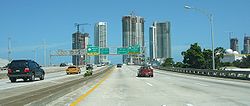
Interstate 395 is a 1.292 miles (2.1 km) long, elevated Interstate Highway that connects Interstate 95
in the west with the MacArthur Causeway
in the east in the Miami area via the Midtown Interchange
. It carries the hidden Florida Department of Transportation
designation of SR 836
.
 I-395 begins at the eastern end of the tolled Dolphin Expressway at the western end of the Midtown Interchange
with I-95, heading as an elevated, six-lane expressway into downtown Miami. The feeder lanes from I-95 to eastbound I-395 make up a separate three lane ramp to the right of I-395, with the exit to US 1
/US 41 being a left exit from the I-395 lanes and a right exit from the I-95 feeder lanes. The feeder lanes then merge into three lanes, heading east towards the MacArthur Causeway, with I-395 terminating after an entrance ramp with US 1
/US 41, and continuing as SR A1A
and unsigned SR 836.
Interstate 395 formerly ended at A1A and US 41 when they merged on to the MacArthur Causeway but the eastern terminus of US 41 was moved from Miami Beach to the Brickell section of Miami at Southwest 8th Street (eastbound), Southwest 7th Street (westbound) and Brickell Avenue (US 1).
On May 24, 2010, construction began on the Miami Port Tunnel
, a $1 billion project that will connect the port to I-95 via I-395. This is being done to reroute the truck and cruise traffic from downtown Miami, currently the only way to access the port. The tunnel is expected to open in 2014.
, Miami-Dade County
.
Interstate 95 in Florida
Interstate 95 is the main Interstate Highway on the east coast of the United States; it serves the Atlantic coast of Florida. It begins at a partial interchange with U.S. Highway 1 just south of downtown Miami, and heads north past Daytona Beach and Jacksonville to the Georgia state line at the St...
in the west with the MacArthur Causeway
MacArthur Causeway
The General Douglas MacArthur Causeway is a six-lane causeway which connects Downtown, Miami, Florida and South Beach, Miami Beach via Biscayne Bay....
in the east in the Miami area via the Midtown Interchange
Midtown Interchange
The Midtown Interchange, located in the Civic Center neighborhood of Miami, Florida, USA, is the convergence of three major motorways: I-95, I-395 , and the Dolphin Expressway ....
. It carries the hidden Florida Department of Transportation
Florida Department of Transportation
The Florida Department of Transportation is a decentralized agency charged with the establishment, maintenance, and regulation of public transportation in the state of Florida. The department was formed in 1969. It absorbed the powers of the Florida State Road Department...
designation of SR 836
State Road 836 (Florida)
State Road 836, locally known as the Dolphin Expressway, is a 19-mile-long six-lane divided expressway, with the westernmost 14 miles being a tollway, currently extending from just north of the intersection of Southwest 137th Avenue and U.S...
.
Route description
Midtown Interchange
The Midtown Interchange, located in the Civic Center neighborhood of Miami, Florida, USA, is the convergence of three major motorways: I-95, I-395 , and the Dolphin Expressway ....
with I-95, heading as an elevated, six-lane expressway into downtown Miami. The feeder lanes from I-95 to eastbound I-395 make up a separate three lane ramp to the right of I-395, with the exit to US 1
U.S. Route 1 in Florida
U.S. Route 1 in Florida runs along the state's east coast from Key West to its crossing of the St. Marys River into Georgia north of Boulogne, and south of Folkston. US 1 was designated through Florida when the U.S. Highway System was established in 1926.US 1 runs in the state of Florida, and...
/US 41 being a left exit from the I-395 lanes and a right exit from the I-95 feeder lanes. The feeder lanes then merge into three lanes, heading east towards the MacArthur Causeway, with I-395 terminating after an entrance ramp with US 1
U.S. Route 1 in Florida
U.S. Route 1 in Florida runs along the state's east coast from Key West to its crossing of the St. Marys River into Georgia north of Boulogne, and south of Folkston. US 1 was designated through Florida when the U.S. Highway System was established in 1926.US 1 runs in the state of Florida, and...
/US 41, and continuing as SR A1A
Florida State Road A1A
State Road A1A is a Florida State Road that runs mostly along the Atlantic Ocean, with sections from Key West at the southern tip of Florida, to Callahan, just south of Georgia. It is the main road through most oceanfront towns. SR A1A is designated the A1A Scenic and Historic Coastal Highway, a...
and unsigned SR 836.
Interstate 395 formerly ended at A1A and US 41 when they merged on to the MacArthur Causeway but the eastern terminus of US 41 was moved from Miami Beach to the Brickell section of Miami at Southwest 8th Street (eastbound), Southwest 7th Street (westbound) and Brickell Avenue (US 1).
History
The interstate was supposed to open with the rest of the Dolphin Expressway in 1968, but was delayed due to a freeze at the federal level for road spending. The expressway opened on March 26, 1971.On May 24, 2010, construction began on the Miami Port Tunnel
Miami port tunnel
The Port of Miami Tunnel is a major construction project in Miami, Florida, with an estimated cost of 1 billion US dollars. The project includes a 3/4 mile long split portal automotive traffic tunnel connecting the MacArthur Causeway on Watson Island and the Port of Miami on Dodge Island, as well...
, a $1 billion project that will connect the port to I-95 via I-395. This is being done to reroute the truck and cruise traffic from downtown Miami, currently the only way to access the port. The tunnel is expected to open in 2014.
Exit list
The entire route is within MiamiMiami, Florida
Miami is a city located on the Atlantic coast in southeastern Florida and the county seat of Miami-Dade County, the most populous county in Florida and the eighth-most populous county in the United States with a population of 2,500,625...
, Miami-Dade County
Miami-Dade County, Florida
Miami-Dade County is a county located in the southeastern part of the state of Florida. As of 2010 U.S. Census, the county had a population of 2,496,435, making it the most populous county in Florida and the eighth-most populous county in the United States...
.
| Mile | # Exit number An exit number is a number assigned to a road junction, usually an exit from a freeway. It is usually marked on the same sign as the destinations of the exit, as well as a sign in the gore.... |
Destinations | Notes |
|---|---|---|---|
| 0.000 | Westbound exit and eastbound entrance; continuation beyond I-95 | ||
| 0.109 | 1 | Westbound exit and eastbound entrance; signed as exits 1A (south) and 1B (north) | |
| 1.061 | 2 | – Arenas | Signed as exit 2B eastbound; exit from SR 836 east is signed as exit 2A |
| 1.292 | Eastbound exit and westbound entrance |
External links
- FDOT GIS dataGeographic Information SystemA geographic information system, geographical information science, or geospatial information studies is a system designed to capture, store, manipulate, analyze, manage, and present all types of geographically referenced data...
- Florida @ SouthEastRoads - Interstate 395 and Florida 836