
North Miami, Florida
Encyclopedia
North Miami is a suburban city located in northeast Miami-Dade County, Florida
, United States
, about 10 miles (16 km) north of Miami. The city lies on Biscayne Bay
and hosts the Biscayne Bay Campus
of Florida International University
, and the North Miami campus of Johnson & Wales University
. Originally the town of "Arch Creek", the area was incorporated as the "Town of Miami Shores", which was renamed the "Town of North Miami" in 1931. Then in 1953, the town was renamed the "City of North Miami."
The city is also home to the Oleta River State Park
, which is the state's largest urban park.
As of 2007, the population recorded by the U.S. Census Bureau is 56,185. With almost 60,000 residents, North Miami is the fourth largest City in Miami-Dade County
.
soldiers in 1856 cut a Military Trail
through nearly impassable thickets and rivers connecting Fort Lauderdale to Fort Dallas
at the mouth of the Miami River
. This eight foot trail, Dade County
’s first roadway, crossed a unique natural bridge -- a natural limestone bridge spanning 40 feet (12 m) across the creek that no longer stands in Arch Creek Memorial Park
-- in an area that would attract a settlement that early on would be known as "Arch Creek
". Even before 1890 a handful of adventuresome pioneers spent brief periods around the Arch Creek Natural Bridge
, a centuries-old Indian settlement.
In 1891, a Mr. Ilhe was the first to put down roots in the Arch Creek
vicinity. He purchased 80 acres (323,748.8 m²) from the State of Florida
at one dollar an acre in the area of today’s N.E. 116th Street and Biscayne Boulevard. The place was so remote that his nearest northern neighbor was thought to live in Ft. Lauderdale. Mr. Ihle built a temporary palmetto frond shelter. During the next 27 years he grew shallots, coontie, squashes, bananas, sugar cane, Puerto Rican pineapples, lemons, guavas, limes, rose apples, Jamaican apples, and tomatoes.
By 1905 the area surrounding the nine year old Arch Creek Railroad Depot had become the community’s hub. It was located at 125th Street and the F.E.C. tracks. That year a post office and a school were opened nearby. By 1912, eighteen homes, a church, a general store, a blacksmith shop, and two tomato packing houses were located around the railroad. The population was estimated at less than one hundred. Farming was still the principal occupation.
The Florida land boom
that was underway in the 1920s spread to Arch Creek farming community. The Biscayne Canal was dug in 1924 to remove farmland from flooded conditions. But as a consequence, the soil began to lose its moisture, and the farming which had been the backbone of the economy, was no longer profitable. However, in step with the times, this drained land became available for partitioning , lot sales, and development.
. The Town limits were: bounded on the South by Miami
and Miami Beach
, on the East by the Atlantic Ocean
, on the West by 17th Avenue, and on the North by a line which approximates Golden Glades Drive or 166th Street. Incorporation moved costs from developers to residents and lot purchasers. Late in 1926 a bond issue of $287,000 was passed to build streets, sidewalks, a town hall, a water system, and fire protection.
The devastating September 1926 hurricane
burst the real estate land speculation. The local community recovered from the damage, but lot sales came to a stop, and the northern tourists names showed up in great numbers on the delinquent tax list. Some money from the bond issue was used to build a Spanish-Mediterranean style city hall building at N.E. 8th Avenue and 125th Street in 1928. The City Hall also housed the police and fire departments. In the 1930s a new water plant and gravity tank was installed behind City Hall. The first newspaper, The Miami Shores Bulletin, was published in 1927-28 and chronicled the events of the times. The historic William Jennings Bryan school was constructed in 1928 on the same spot where the Arch Creek Elementary School had burned down the year before.
decision. The 1926 hurricane ended plans for a causeway to deliver municipal services to that area of town. With no services being received, the beach area instituted a lengthy court lawsuit to separate and form their own community.
The wealthy Shoreland Company, located to the south of the Town, lobbied the 1931 Florida Legislature
to officially grant their huge development the name "Village of Miami Shores
". The Legislature did so. It also passed an official act abolishing "Town of Miami Shores" as a name. The next step was for the local population to choose a new name. The municipality was renamed The Town of North Miami.
During the Depression years
, in 1933, Mrs. Cecille Sevier and Mrs. Ella S. Klefeker became the first two women elected to the Town Council. The 1940s census stated that 1,973 inhabitants lived in the "Town of North Miami".
in 1945, the large and constant influx of former military veterans and their young families changed the face of North Miami by ushering in a great growth period. Homebuilding, road building, shops, stores, and office business construction now continued for decades almost without stopping. By 1951 it was reported nationally that North Miami was one of the fastest growing towns in the United States. During this time, the growing community needed a high school, so in 1951 construction started for North Miami High School
. In August 1954, North Miami High School
opened its doors for the children of the growing community.
Partially to meet this challenge of fast growth, the voters of North Miami in 1952 voted to adopt a new charter and a new name. The new charter, enacted as an official statute of the Florida Legislature
on May 27, 1953 provided for the establishment of a full-time administrative head (City Manager form of government) to carry out the policies of the elected Mayor/Council. The new and present name officially introduced on this date - the City of North Miami.
North Miami is known for its large Haitian-American population. In 2001, voters made Republican
Josaphat Celestin
the first Haitian American mayor of a large Miami-Dade County community.
According to the United States Census Bureau
, the city has a total area of 10 square miles (25.9 km²). 8.5 square miles (22 km²) of it is land and 1.5 square miles (3.9 km²) of it (15.32%) is water.
(Köppen climate classification
Am).
, North Miami Beach
Opa-locka


 Sunny Isles Beach
Westview

 Sunny Isles Beach
, Biscayne Bay
, Bay Harbor Islands
Westview


 Biscayne Bay
of 2000, there are 59,880 people, 20,541 households, and 13,577 families residing in the city. The population density
is 7,080.0 inhabitants per square mile (2,732.8/km2). There are 22,281 housing units at an average density of 2,634.4 per square mile (1,016.9/km2). The racial makeup of the city is 34.81% White (18.1% were Non-Hispanic White,) 54.89% African American or Black (with a large majority being of Caribbean
ancestry,) 0.32% Native American
, 1.92% Asia
n, 0.05% Pacific Islander, 3.16% from other races, and 4.85% from two or more races. 23.16% of the population are Hispanic
or Latino
of any race.
There were 20,541 households out of which 37.6% had children under the age of 18 living with them, 39.0% were married couples
living together, 20.1% had a female householder with no husband present, and 33.9% were non-families. 26.9% of all households were made up of individuals and 6.8% had someone living alone who was 65 years of age or older. The average household size was 2.85 and the average family size was 3.51.
In the city the population was spread out with 28.1% under the age of 18, 11.3% from 18 to 24, 31.8% from 25 to 44, 19.6% from 45 to 64, and 9.2% who were 65 years of age or older. The median age was 32 years. For every 100 females there were 92.7 males. For every 100 females age 18 and over, there were 89.0 males.
The median income for a household in the city was $29,778, and the median income for a family was $31,760. Males had a median income of $25,388 versus $20,712 for females. The per capita income
for the city was $14,581. About 20.7% of families and 23.9% of the population were below the poverty line, including 29.5% of those under age 18 and 17.2% of those age 65 or over.
As of 2000, residents who spoke English
as a mother tongue were 35.49% of the population, while French Creole made up 33.28%, Spanish
was at 24.88%, and French
accounted for 2.69% of the population.
As of 2000, North Miami had the second highest percentage of Haiti
an residents in the US, with 33% of the US populace (the first highest concentration, at 33.5% of the US population, was Golden Glades
.) It had the seventy-first highest percentage of Cuba
n residents in the US, at 4.43% of the city's population, and the ninety-first highest percentage of Dominican
residents in the US, at 1.72% of the city's population (tied with Golden Glades
and East Newark, New Jersey
.) It also had the sixth most Bahamians
in the US, at 1.2% of all residents (tied with West Little River
.) North Miami's Jamaica
n community had the fortieth highest percentage, at 3.3% of the population (tied with Plainfield, New Jersey
.)
service called the NoMi Express, in order to increase the number of local destinations that can be reached through public transit. Since its inauguration in December, 2004, the NoMi Express averages approximately 750 boardings per day, which translates to 16,000 boardings per month or 190,000 boardings annually.
The master-planned development will feature approximately 120000 square feet (11,148.4 m²) of commercial office and retail space, 2,800 to 5,000 residential units, a park and recreation facilities. As part of the development agreement for the site, the project’s developer has also committed to renovating the city’s library and building a school, Olympic training facility, and affordable housing on several sites located in North Miami. Completion of all elements of the project are projected by 2021.
A portion of the Biscayne Landing site includes some of the wetlands of Biscayne Bay, which will be preserved in the form of a 35 acres (141,640.1 m²) environmental park, containing nature hikes, jogging paths, information plaques that describe the resident wildlife and trees, benches, a canoe landing and a boat house. It will also have connecting trails to Oleta River State Park. This area is the site of a former trash dump and is the home to a large sewage treatment plant nearby.
In 2009, Biscayne Landing is reeling in the real estate downturn. Most of the units in the two buildings online so far are uninhabited; very few are selling. There is little actual construction on any other project related to their contractual obligations under a redevelopment agreement with the City of North Miami.
A group of North Miami voters, enraged over the millions of taxpayer dollars awarded Biscayne Landings' developers, founded www.ChangeNorthMiami.com to assure the June 2, 2009 mayoral election is a vote of no confidence for the failed development and affiliated affordable housing plans, also stalled.
serves North Miami.
Miami-Dade County, Florida
Miami-Dade County is a county located in the southeastern part of the state of Florida. As of 2010 U.S. Census, the county had a population of 2,496,435, making it the most populous county in Florida and the eighth-most populous county in the United States...
, United States
United States
The United States of America is a federal constitutional republic comprising fifty states and a federal district...
, about 10 miles (16 km) north of Miami. The city lies on Biscayne Bay
Biscayne Bay
Biscayne Bay is a lagoon that is approximately 35 miles long and up to 8 miles wide located on the Atlantic coast of South Florida, United States. It is usually divided for purposes of discussion and analysis into three parts: North Bay, Central Bay, and South Bay. Its area is...
and hosts the Biscayne Bay Campus
Biscayne Bay Campus
The Biscayne Bay Campus is a campus of Florida International University located in North Miami, Florida. It is 40 minutes away from the Modesto Madique campus...
of Florida International University
Florida International University
Florida International University is an American public research university in metropolitan Miami, Florida, in the United States, with its main campus in University Park...
, and the North Miami campus of Johnson & Wales University
Johnson & Wales University
Johnson & Wales University is a private, nonprofit, co-educational, career-oriented university with four campuses located throughout the United States. Providence, Rhode Island, USA, is home to JWU's first and largest of four currently operating campuses. Founded as a business school in 1914, by...
. Originally the town of "Arch Creek", the area was incorporated as the "Town of Miami Shores", which was renamed the "Town of North Miami" in 1931. Then in 1953, the town was renamed the "City of North Miami."
The city is also home to the Oleta River State Park
Oleta River State Park
The Oleta River State Park is a Florida State Park system on Biscayne Bay in the municipal suburb of North Miami in metropolitan Miami, Florida...
, which is the state's largest urban park.
As of 2007, the population recorded by the U.S. Census Bureau is 56,185. With almost 60,000 residents, North Miami is the fourth largest City in Miami-Dade County
Miami-Dade County, Florida
Miami-Dade County is a county located in the southeastern part of the state of Florida. As of 2010 U.S. Census, the county had a population of 2,496,435, making it the most populous county in Florida and the eighth-most populous county in the United States...
.
Early history
In the final phase of Indian inhabitation of the area that eventually became "North Miami", United States ArmyUnited States Army
The United States Army is the main branch of the United States Armed Forces responsible for land-based military operations. It is the largest and oldest established branch of the U.S. military, and is one of seven U.S. uniformed services...
soldiers in 1856 cut a Military Trail
Military Trail
Military Trail may refer to:*Florida State Road 809 in Florida, United States*Military Trail, a road in Toronto, Ontario, Canada. See Danforth Avenue....
through nearly impassable thickets and rivers connecting Fort Lauderdale to Fort Dallas
Fort Dallas
Fort Dallas is a urban park in the Lummus Park Historic District of Miami, Florida, just west of Downtown. It once acted as a military base during the Seminole Wars, located on the banks of the Miami River in what is now Downtown, Miami, Florida, United States....
at the mouth of the Miami River
Miami River (Florida)
The Miami River is a river in the United States state of Florida that drains out of the Everglades and runs through the Downtown and the city of Miami. The long river flows from the terminus of the Miami Canal at Miami International Airport to Biscayne Bay...
. This eight foot trail, Dade County
Miami-Dade County, Florida
Miami-Dade County is a county located in the southeastern part of the state of Florida. As of 2010 U.S. Census, the county had a population of 2,496,435, making it the most populous county in Florida and the eighth-most populous county in the United States...
’s first roadway, crossed a unique natural bridge -- a natural limestone bridge spanning 40 feet (12 m) across the creek that no longer stands in Arch Creek Memorial Park
Arch Creek
Arch Creek was an early settlement in Miami-Dade County, Florida, in present-day metropolitan Miami. Tequesta Indians thrived here before the first Europeans arrived in the early 16th century. The name is derived from the natural limestone bridge spanning across the creek. It is part of the Arch...
-- in an area that would attract a settlement that early on would be known as "Arch Creek
Arch Creek
Arch Creek was an early settlement in Miami-Dade County, Florida, in present-day metropolitan Miami. Tequesta Indians thrived here before the first Europeans arrived in the early 16th century. The name is derived from the natural limestone bridge spanning across the creek. It is part of the Arch...
". Even before 1890 a handful of adventuresome pioneers spent brief periods around the Arch Creek Natural Bridge
Arch Creek
Arch Creek was an early settlement in Miami-Dade County, Florida, in present-day metropolitan Miami. Tequesta Indians thrived here before the first Europeans arrived in the early 16th century. The name is derived from the natural limestone bridge spanning across the creek. It is part of the Arch...
, a centuries-old Indian settlement.
In 1891, a Mr. Ilhe was the first to put down roots in the Arch Creek
Arch Creek
Arch Creek was an early settlement in Miami-Dade County, Florida, in present-day metropolitan Miami. Tequesta Indians thrived here before the first Europeans arrived in the early 16th century. The name is derived from the natural limestone bridge spanning across the creek. It is part of the Arch...
vicinity. He purchased 80 acres (323,748.8 m²) from the State of Florida
Florida
Florida is a state in the southeastern United States, located on the nation's Atlantic and Gulf coasts. It is bordered to the west by the Gulf of Mexico, to the north by Alabama and Georgia and to the east by the Atlantic Ocean. With a population of 18,801,310 as measured by the 2010 census, it...
at one dollar an acre in the area of today’s N.E. 116th Street and Biscayne Boulevard. The place was so remote that his nearest northern neighbor was thought to live in Ft. Lauderdale. Mr. Ihle built a temporary palmetto frond shelter. During the next 27 years he grew shallots, coontie, squashes, bananas, sugar cane, Puerto Rican pineapples, lemons, guavas, limes, rose apples, Jamaican apples, and tomatoes.
By 1905 the area surrounding the nine year old Arch Creek Railroad Depot had become the community’s hub. It was located at 125th Street and the F.E.C. tracks. That year a post office and a school were opened nearby. By 1912, eighteen homes, a church, a general store, a blacksmith shop, and two tomato packing houses were located around the railroad. The population was estimated at less than one hundred. Farming was still the principal occupation.
The Florida land boom
Florida land boom of the 1920s
The Florida land boom of the 1920s was Florida's first real estate bubble, which burst in 1925, leaving behind entire new cities and the remains of failed development projects such as Aladdin City in south Miami-Dade County and Isola di Lolando in north Biscayne Bay...
that was underway in the 1920s spread to Arch Creek farming community. The Biscayne Canal was dug in 1924 to remove farmland from flooded conditions. But as a consequence, the soil began to lose its moisture, and the farming which had been the backbone of the economy, was no longer profitable. However, in step with the times, this drained land became available for partitioning , lot sales, and development.
Birth of North Miami
Thirty eight out of the forty seven registered voters, at the encouragement of developers E.C. Harner, Earl Irons and Arthur Griffing, showed up and voted to incorporate into a town on February 5, 1926. North Miami, between 1926 and 1931, was named "Town of Miami Shores", partially because its early eastern boundary was the Atlantic OceanAtlantic Ocean
The Atlantic Ocean is the second-largest of the world's oceanic divisions. With a total area of about , it covers approximately 20% of the Earth's surface and about 26% of its water surface area...
. The Town limits were: bounded on the South by Miami
Miami, Florida
Miami is a city located on the Atlantic coast in southeastern Florida and the county seat of Miami-Dade County, the most populous county in Florida and the eighth-most populous county in the United States with a population of 2,500,625...
and Miami Beach
Miami Beach, Florida
Miami Beach is a coastal resort city in Miami-Dade County, Florida, United States, incorporated on March 26, 1915. The municipality is located on a barrier island between the Atlantic Ocean and Biscayne Bay, the latter which separates the Beach from Miami city proper...
, on the East by the Atlantic Ocean
Atlantic Ocean
The Atlantic Ocean is the second-largest of the world's oceanic divisions. With a total area of about , it covers approximately 20% of the Earth's surface and about 26% of its water surface area...
, on the West by 17th Avenue, and on the North by a line which approximates Golden Glades Drive or 166th Street. Incorporation moved costs from developers to residents and lot purchasers. Late in 1926 a bond issue of $287,000 was passed to build streets, sidewalks, a town hall, a water system, and fire protection.
The devastating September 1926 hurricane
1926 Miami Hurricane
The 1926 Miami hurricane was a Category 4 hurricane that devastated Miami in September 1926. The storm also caused significant damage in the Florida Panhandle, the U.S. state of Alabama, and the Bahamas...
burst the real estate land speculation. The local community recovered from the damage, but lot sales came to a stop, and the northern tourists names showed up in great numbers on the delinquent tax list. Some money from the bond issue was used to build a Spanish-Mediterranean style city hall building at N.E. 8th Avenue and 125th Street in 1928. The City Hall also housed the police and fire departments. In the 1930s a new water plant and gravity tank was installed behind City Hall. The first newspaper, The Miami Shores Bulletin, was published in 1927-28 and chronicled the events of the times. The historic William Jennings Bryan school was constructed in 1928 on the same spot where the Arch Creek Elementary School had burned down the year before.
The 1930s
Seven miles (11 km) of Atlantic Oceanfront beachland property from the Broward County line southward to Surfside were removed from the town limits as a result of a 1931 Florida Supreme CourtFlorida Supreme Court
The Supreme Court of the State of Florida is the highest court in the U.S. state of Florida. The Supreme Court consists of seven judges: the Chief Justice and six Justices who are appointed by the Governor to 6-year terms and remain in office if retained in a general election near the end of each...
decision. The 1926 hurricane ended plans for a causeway to deliver municipal services to that area of town. With no services being received, the beach area instituted a lengthy court lawsuit to separate and form their own community.
The wealthy Shoreland Company, located to the south of the Town, lobbied the 1931 Florida Legislature
Florida Legislature
The Florida State Legislature is the term often used to refer to the two houses that act as the state legislature of the U.S. state of Florida. The Florida Constitution states that "The legislative power of the state shall be vested in a legislature of the State of Florida," composed of a Senate...
to officially grant their huge development the name "Village of Miami Shores
Miami Shores, Florida
Miami Shores is a village in Miami-Dade County, Florida, United States. The population was 10,380 at the 2000 census. As of 2005, the population recorded by the U.S. Census Bureau is 10,040....
". The Legislature did so. It also passed an official act abolishing "Town of Miami Shores" as a name. The next step was for the local population to choose a new name. The municipality was renamed The Town of North Miami.
During the Depression years
Great Depression
The Great Depression was a severe worldwide economic depression in the decade preceding World War II. The timing of the Great Depression varied across nations, but in most countries it started in about 1929 and lasted until the late 1930s or early 1940s...
, in 1933, Mrs. Cecille Sevier and Mrs. Ella S. Klefeker became the first two women elected to the Town Council. The 1940s census stated that 1,973 inhabitants lived in the "Town of North Miami".
Post World War II growth
At the end of World War IIWorld War II
World War II, or the Second World War , was a global conflict lasting from 1939 to 1945, involving most of the world's nations—including all of the great powers—eventually forming two opposing military alliances: the Allies and the Axis...
in 1945, the large and constant influx of former military veterans and their young families changed the face of North Miami by ushering in a great growth period. Homebuilding, road building, shops, stores, and office business construction now continued for decades almost without stopping. By 1951 it was reported nationally that North Miami was one of the fastest growing towns in the United States. During this time, the growing community needed a high school, so in 1951 construction started for North Miami High School
North Miami High School
North Miami Senior High School , is a secondary school located at 800 NE 137th St in the city of North Miami, Florida, USA.North Miami Senior High School opened as Edward L. Constans Junior-Senior High School in 1951, with 1,500 students in 7th, 8th and 9th grades. Another grade was added each year...
. In August 1954, North Miami High School
North Miami High School
North Miami Senior High School , is a secondary school located at 800 NE 137th St in the city of North Miami, Florida, USA.North Miami Senior High School opened as Edward L. Constans Junior-Senior High School in 1951, with 1,500 students in 7th, 8th and 9th grades. Another grade was added each year...
opened its doors for the children of the growing community.
Partially to meet this challenge of fast growth, the voters of North Miami in 1952 voted to adopt a new charter and a new name. The new charter, enacted as an official statute of the Florida Legislature
Florida Legislature
The Florida State Legislature is the term often used to refer to the two houses that act as the state legislature of the U.S. state of Florida. The Florida Constitution states that "The legislative power of the state shall be vested in a legislature of the State of Florida," composed of a Senate...
on May 27, 1953 provided for the establishment of a full-time administrative head (City Manager form of government) to carry out the policies of the elected Mayor/Council. The new and present name officially introduced on this date - the City of North Miami.
North Miami is known for its large Haitian-American population. In 2001, voters made Republican
Republican Party (United States)
The Republican Party is one of the two major contemporary political parties in the United States, along with the Democratic Party. Founded by anti-slavery expansion activists in 1854, it is often called the GOP . The party's platform generally reflects American conservatism in the U.S...
Josaphat Celestin
Josaphat Celestin
Josaphat J. Celestin, also known as Joe Celestin, is a Haitian-American politician who served as the mayor of North Miami, Florida from 2001 to 2005...
the first Haitian American mayor of a large Miami-Dade County community.
Geography
North Miami is located at 25.895022°N 80.185747°W.According to the United States Census Bureau
United States Census Bureau
The United States Census Bureau is the government agency that is responsible for the United States Census. It also gathers other national demographic and economic data...
, the city has a total area of 10 square miles (25.9 km²). 8.5 square miles (22 km²) of it is land and 1.5 square miles (3.9 km²) of it (15.32%) is water.
Climate
North Miami has a tropical monsoon climateTropical monsoon climate
Tropical monsoon climate, occasionally also known as a tropical wet climate or tropical monsoon and trade-wind littoral climate in climate classification, is a relatively rare type of climate that corresponds to the Köppen climate classification category "Am."Tropical monsoon climates have monthly...
(Köppen climate classification
Köppen climate classification
The Köppen climate classification is one of the most widely used climate classification systems. It was first published by Crimea German climatologist Wladimir Köppen in 1884, with several later modifications by Köppen himself, notably in 1918 and 1936...
Am).
Surrounding areas
Golden GladesGolden Glades, Florida
Golden Glades is a census-designated place in Miami-Dade County, Florida, United States. The population was 32,623 at the 2000 census.It is the location for a major highway interchange of the same name which connects the Florida Turnpike, Interstate 95, US 441, State Road 9, and the Palmetto...
, North Miami Beach
North Miami Beach, Florida
North Miami Beach is a Miami suburban city in Miami-Dade County, Florida, United States. Originally named Fulford in 1926 after Captain William H. Fulford of the United States Coast Guard, the city was incorporated in 1927 as Fulford, but was renamed North Miami Beach in 1931. The population was...
Opa-locka
Opa-locka, Florida
Opa-locka is a city located in Miami-Dade County, Florida, United States. As of the mid decade census, the population was 15,376 as recorded by the U.S. Census Bureau....
Sunny Isles Beach, Florida
Sunny Isles Beach is a city located on a barrier island in northeast Miami-Dade County, Florida, United States. The City is bounded by the Atlantic Ocean on the east and the Intracoastal Waterway on the west...
Westview
Westview, Florida
As of the census of 2000, there were 9,692 people, 2,914 households, and 2,235 families residing in the CDP. The population density was 3,109.2 people per square mile . There were 3,111 housing units at an average density of 998.0/sq mi...
Sunny Isles BeachSunny Isles Beach, Florida
Sunny Isles Beach is a city located on a barrier island in northeast Miami-Dade County, Florida, United States. The City is bounded by the Atlantic Ocean on the east and the Intracoastal Waterway on the west...
, Biscayne Bay
Biscayne Bay
Biscayne Bay is a lagoon that is approximately 35 miles long and up to 8 miles wide located on the Atlantic coast of South Florida, United States. It is usually divided for purposes of discussion and analysis into three parts: North Bay, Central Bay, and South Bay. Its area is...
, Bay Harbor Islands
Bay Harbor Islands, Florida
Bay Harbor Islands is a town in Miami-Dade County, Florida, United States. The population was 5,146 at the 2000 census. It is separated from the mainland by Biscayne Bay, with which it is connected via the Broad Causeway. On the mainland side, BHI is bordered by the city of North Miami, while to...
Westview
Westview, Florida
As of the census of 2000, there were 9,692 people, 2,914 households, and 2,235 families residing in the CDP. The population density was 3,109.2 people per square mile . There were 3,111 housing units at an average density of 998.0/sq mi...
Biscayne Bay
Biscayne Bay is a lagoon that is approximately 35 miles long and up to 8 miles wide located on the Atlantic coast of South Florida, United States. It is usually divided for purposes of discussion and analysis into three parts: North Bay, Central Bay, and South Bay. Its area is...
- PinewoodPinewood, FloridaPinewood is a census-designated place in Miami-Dade County, Florida, United States. The population was 16,520 at the 2010 census.-Geography:Pinewood is located at ....
, Unincorporated Miami-Dade CountyMiami-Dade County, FloridaMiami-Dade County is a county located in the southeastern part of the state of Florida. As of 2010 U.S. Census, the county had a population of 2,496,435, making it the most populous county in Florida and the eighth-most populous county in the United States...
, Biscayne ParkBiscayne Park, FloridaBiscayne Park is a village in Miami-Dade County, Florida, United States. The population was 3,269 at the 2000 census. Biscayne Park was developed in the 1920's by Arthur Griffing. The area was annexed by the city of Miami in 1925 but with the arrival of the Great Depression Miami gave up...
Demographics
As of the censusCensus
A census is the procedure of systematically acquiring and recording information about the members of a given population. It is a regularly occurring and official count of a particular population. The term is used mostly in connection with national population and housing censuses; other common...
of 2000, there are 59,880 people, 20,541 households, and 13,577 families residing in the city. The population density
Population density
Population density is a measurement of population per unit area or unit volume. It is frequently applied to living organisms, and particularly to humans...
is 7,080.0 inhabitants per square mile (2,732.8/km2). There are 22,281 housing units at an average density of 2,634.4 per square mile (1,016.9/km2). The racial makeup of the city is 34.81% White (18.1% were Non-Hispanic White,) 54.89% African American or Black (with a large majority being of Caribbean
Caribbean
The Caribbean is a crescent-shaped group of islands more than 2,000 miles long separating the Gulf of Mexico and the Caribbean Sea, to the west and south, from the Atlantic Ocean, to the east and north...
ancestry,) 0.32% Native American
Native Americans in the United States
Native Americans in the United States are the indigenous peoples in North America within the boundaries of the present-day continental United States, parts of Alaska, and the island state of Hawaii. They are composed of numerous, distinct tribes, states, and ethnic groups, many of which survive as...
, 1.92% Asia
Asia
Asia is the world's largest and most populous continent, located primarily in the eastern and northern hemispheres. It covers 8.7% of the Earth's total surface area and with approximately 3.879 billion people, it hosts 60% of the world's current human population...
n, 0.05% Pacific Islander, 3.16% from other races, and 4.85% from two or more races. 23.16% of the population are Hispanic
Hispanic
Hispanic is a term that originally denoted a relationship to Hispania, which is to say the Iberian Peninsula: Andorra, Gibraltar, Portugal and Spain. During the Modern Era, Hispanic sometimes takes on a more limited meaning, particularly in the United States, where the term means a person of ...
or Latino
Latino
The demonyms Latino and Latina , are defined in English language dictionaries as:* "a person of Latin-American descent."* "A Latin American."* "A person of Hispanic, especially Latin-American, descent, often one living in the United States."...
of any race.
There were 20,541 households out of which 37.6% had children under the age of 18 living with them, 39.0% were married couples
Marriage
Marriage is a social union or legal contract between people that creates kinship. It is an institution in which interpersonal relationships, usually intimate and sexual, are acknowledged in a variety of ways, depending on the culture or subculture in which it is found...
living together, 20.1% had a female householder with no husband present, and 33.9% were non-families. 26.9% of all households were made up of individuals and 6.8% had someone living alone who was 65 years of age or older. The average household size was 2.85 and the average family size was 3.51.
In the city the population was spread out with 28.1% under the age of 18, 11.3% from 18 to 24, 31.8% from 25 to 44, 19.6% from 45 to 64, and 9.2% who were 65 years of age or older. The median age was 32 years. For every 100 females there were 92.7 males. For every 100 females age 18 and over, there were 89.0 males.
The median income for a household in the city was $29,778, and the median income for a family was $31,760. Males had a median income of $25,388 versus $20,712 for females. The per capita income
Per capita income
Per capita income or income per person is a measure of mean income within an economic aggregate, such as a country or city. It is calculated by taking a measure of all sources of income in the aggregate and dividing it by the total population...
for the city was $14,581. About 20.7% of families and 23.9% of the population were below the poverty line, including 29.5% of those under age 18 and 17.2% of those age 65 or over.
As of 2000, residents who spoke English
English language
English is a West Germanic language that arose in the Anglo-Saxon kingdoms of England and spread into what was to become south-east Scotland under the influence of the Anglian medieval kingdom of Northumbria...
as a mother tongue were 35.49% of the population, while French Creole made up 33.28%, Spanish
Spanish language
Spanish , also known as Castilian , is a Romance language in the Ibero-Romance group that evolved from several languages and dialects in central-northern Iberia around the 9th century and gradually spread with the expansion of the Kingdom of Castile into central and southern Iberia during the...
was at 24.88%, and French
French language
French is a Romance language spoken as a first language in France, the Romandy region in Switzerland, Wallonia and Brussels in Belgium, Monaco, the regions of Quebec and Acadia in Canada, and by various communities elsewhere. Second-language speakers of French are distributed throughout many parts...
accounted for 2.69% of the population.
As of 2000, North Miami had the second highest percentage of Haiti
Haiti
Haiti , officially the Republic of Haiti , is a Caribbean country. It occupies the western, smaller portion of the island of Hispaniola, in the Greater Antillean archipelago, which it shares with the Dominican Republic. Ayiti was the indigenous Taíno or Amerindian name for the island...
an residents in the US, with 33% of the US populace (the first highest concentration, at 33.5% of the US population, was Golden Glades
Golden Glades, Florida
Golden Glades is a census-designated place in Miami-Dade County, Florida, United States. The population was 32,623 at the 2000 census.It is the location for a major highway interchange of the same name which connects the Florida Turnpike, Interstate 95, US 441, State Road 9, and the Palmetto...
.) It had the seventy-first highest percentage of Cuba
Cuba
The Republic of Cuba is an island nation in the Caribbean. The nation of Cuba consists of the main island of Cuba, the Isla de la Juventud, and several archipelagos. Havana is the largest city in Cuba and the country's capital. Santiago de Cuba is the second largest city...
n residents in the US, at 4.43% of the city's population, and the ninety-first highest percentage of Dominican
Dominican Republic
The Dominican Republic is a nation on the island of La Hispaniola, part of the Greater Antilles archipelago in the Caribbean region. The western third of the island is occupied by the nation of Haiti, making Hispaniola one of two Caribbean islands that are shared by two countries...
residents in the US, at 1.72% of the city's population (tied with Golden Glades
Golden Glades, Florida
Golden Glades is a census-designated place in Miami-Dade County, Florida, United States. The population was 32,623 at the 2000 census.It is the location for a major highway interchange of the same name which connects the Florida Turnpike, Interstate 95, US 441, State Road 9, and the Palmetto...
and East Newark, New Jersey
East Newark, New Jersey
East Newark is a borough in Hudson County, New Jersey, United States. As of the 2010 United States Census, the borough population was 2,406. The borough is a suburb of the nearby city of Newark....
.) It also had the sixth most Bahamians
The Bahamas
The Bahamas , officially the Commonwealth of the Bahamas, is a nation consisting of 29 islands, 661 cays, and 2,387 islets . It is located in the Atlantic Ocean north of Cuba and Hispaniola , northwest of the Turks and Caicos Islands, and southeast of the United States...
in the US, at 1.2% of all residents (tied with West Little River
West Little River, Florida
West Little River is a census-designated place in Miami-Dade County, Florida, United States. The population was 34,699 at the 2010 census.-Geography:West Little River is located at...
.) North Miami's Jamaica
Jamaica
Jamaica is an island nation of the Greater Antilles, in length, up to in width and 10,990 square kilometres in area. It is situated in the Caribbean Sea, about south of Cuba, and west of Hispaniola, the island harbouring the nation-states Haiti and the Dominican Republic...
n community had the fortieth highest percentage, at 3.3% of the population (tied with Plainfield, New Jersey
Plainfield, New Jersey
Plainfield is a city in Union County, New Jersey, United States. As of the 2010 United States Census, the city's population increased to a record high of 49,808....
.)
Government
North Miami is governed using the council-manager system. The mayor and the City Clerk are elected at large. There are four districts each electing one member of the council. The council has authority over the manager.Transportation
In December 2004, the City of North Miami implemented a free community busBus
A bus is a road vehicle designed to carry passengers. Buses can have a capacity as high as 300 passengers. The most common type of bus is the single-decker bus, with larger loads carried by double-decker buses and articulated buses, and smaller loads carried by midibuses and minibuses; coaches are...
service called the NoMi Express, in order to increase the number of local destinations that can be reached through public transit. Since its inauguration in December, 2004, the NoMi Express averages approximately 750 boardings per day, which translates to 16,000 boardings per month or 190,000 boardings annually.
Museums
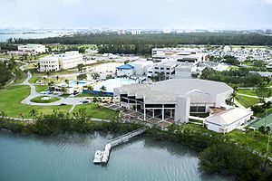
- The Museum of Contemporary Art (MOCA) is a museumMuseumA museum is an institution that cares for a collection of artifacts and other objects of scientific, artistic, cultural, or historical importance and makes them available for public viewing through exhibits that may be permanent or temporary. Most large museums are located in major cities...
located in the heart of downtown North Miami, Florida. The 23000 square feet (2,136.8 m²) structure was designed by the internationally acclaimed architect Charles GwathmeyCharles GwathmeyCharles Gwathmey was an American architect. He was a principal at Gwathmey Siegel & Associates Architects, as well as one of the five architects identified as The New York Five in 1969...
of Gwathmey Siegel, New YorkNew YorkNew York is a state in the Northeastern region of the United States. It is the nation's third most populous state. New York is bordered by New Jersey and Pennsylvania to the south, and by Connecticut, Massachusetts and Vermont to the east...
, who worked in conjunction with the MiamiMiami, FloridaMiami is a city located on the Atlantic coast in southeastern Florida and the county seat of Miami-Dade County, the most populous county in Florida and the eighth-most populous county in the United States with a population of 2,500,625...
firm of Gelabert-Navia to create the building.
State parks
- The Oleta River State Park is the largest urban park in the Florida State Park system. The park is located on 1043 acres (4.2 km²) - 993 acres (4 km²) of land and 50 acre (0.202343 km²) of inland water - on Biscayne BayBiscayne BayBiscayne Bay is a lagoon that is approximately 35 miles long and up to 8 miles wide located on the Atlantic coast of South Florida, United States. It is usually divided for purposes of discussion and analysis into three parts: North Bay, Central Bay, and South Bay. Its area is...
, in the northeastern end of the city of North Miami in Miami-Dade CountyMiami-Dade County, FloridaMiami-Dade County is a county located in the southeastern part of the state of Florida. As of 2010 U.S. Census, the county had a population of 2,496,435, making it the most populous county in Florida and the eighth-most populous county in the United States...
, FloridaFloridaFlorida is a state in the southeastern United States, located on the nation's Atlantic and Gulf coasts. It is bordered to the west by the Gulf of Mexico, to the north by Alabama and Georgia and to the east by the Atlantic Ocean. With a population of 18,801,310 as measured by the 2010 census, it...
, and adjoins the Biscayne Bay CampusBiscayne Bay CampusThe Biscayne Bay Campus is a campus of Florida International University located in North Miami, Florida. It is 40 minutes away from the Modesto Madique campus...
of Florida International UniversityFlorida International UniversityFlorida International University is an American public research university in metropolitan Miami, Florida, in the United States, with its main campus in University Park...
. In some documents, the park is designated as the Oleta River State Recreation Area. The park contains one of the largest concentrations of Australian Pine trees (an invasive speciesInvasive species"Invasive species", or invasive exotics, is a nomenclature term and categorization phrase used for flora and fauna, and for specific restoration-preservation processes in native habitats, with several definitions....
) found in a Florida State Park.
- The Arch Creek Park was formally dedicated on April 25, 1982. Today, Arch Creek is an 8 acres (32,374.9 m²) site at the junction of N.E. 135th Street and Biscayne Boulevard in North Miami, Fla., and offers many opportunities for botanical, historical and archaeological study. It has a museum/nature center modeled after an early Florida pioneer home, displaying Indian artifacts dug from the grounds, and live animals from the nearby hammock. Remains of the original coontie mill are still visible across the creek, and the Park exists as the only preserved archaeological site in the County.
Biscayne Landing
Biscayne Landing is a mixed use commercial/hotel/residential community being developed on the site of the Munisport Landfill Superfund Site. The City of North Miami will retain ownership of this Brownfield site and the developers, Boca Developers, will retain a 200 year lease for the development of the project.The master-planned development will feature approximately 120000 square feet (11,148.4 m²) of commercial office and retail space, 2,800 to 5,000 residential units, a park and recreation facilities. As part of the development agreement for the site, the project’s developer has also committed to renovating the city’s library and building a school, Olympic training facility, and affordable housing on several sites located in North Miami. Completion of all elements of the project are projected by 2021.
A portion of the Biscayne Landing site includes some of the wetlands of Biscayne Bay, which will be preserved in the form of a 35 acres (141,640.1 m²) environmental park, containing nature hikes, jogging paths, information plaques that describe the resident wildlife and trees, benches, a canoe landing and a boat house. It will also have connecting trails to Oleta River State Park. This area is the site of a former trash dump and is the home to a large sewage treatment plant nearby.
In 2009, Biscayne Landing is reeling in the real estate downturn. Most of the units in the two buildings online so far are uninhabited; very few are selling. There is little actual construction on any other project related to their contractual obligations under a redevelopment agreement with the City of North Miami.
A group of North Miami voters, enraged over the millions of taxpayer dollars awarded Biscayne Landings' developers, founded www.ChangeNorthMiami.com to assure the June 2, 2009 mayoral election is a vote of no confidence for the failed development and affiliated affordable housing plans, also stalled.
Primary and secondary schools
Miami-Dade County Public SchoolsMiami-Dade County Public Schools
Miami-Dade County Public Schools is a public school district serving Miami-Dade County, Florida. Founded in 1885, it is the largest school district in Florida and the Southeastern United States, and the fourth largest in the United States, with a student enrollment of 380,006 as of July 5, 2010...
serves North Miami.
Elementary schools
- Benjamin Franklin Elementary School
- Biscayne Gardens Elementary School
- Gratigny Elementary
- North Miami Elementary School
- Natural Bridge Elementary School
- W. J. Bryan Elementary School
Middle schools
- Thomas Jefferson Middle School
- North Miami Middle School
K-8 centers
- David Lawrence Jr. K-8 Center
- Linda Lentin K-8 Center
High schools
- Alonzo and Tracy Mourning Senior High Biscayne Bay CampusAlonzo and Tracy Mourning Senior High Biscayne Bay CampusAlonzo and Tracy Mourning Sr. High Biscayne Bay Campus is a secondary school in North Miami, Florida, United States which opened August 2009, built two blocks north of Florida International University's Biscayne Bay Campus. It is part of the Miami-Dade County Public Schools system. Built to relieve...
- North Miami Senior High School
Private schools
- Northwest Christian Academy
- Holy Cross Lutheran School
- Yeshiva Toras Chaim
- Miami Union Academy SDA
- Montessori School of North Miami
Colleges and universities
- Florida International UniversityBiscayne Bay CampusThe Biscayne Bay Campus is a campus of Florida International University located in North Miami, Florida. It is 40 minutes away from the Modesto Madique campus...
(Biscayne Bay CampusBiscayne Bay CampusThe Biscayne Bay Campus is a campus of Florida International University located in North Miami, Florida. It is 40 minutes away from the Modesto Madique campus...
) - Johnson & Wales UniversityJohnson & Wales UniversityJohnson & Wales University is a private, nonprofit, co-educational, career-oriented university with four campuses located throughout the United States. Providence, Rhode Island, USA, is home to JWU's first and largest of four currently operating campuses. Founded as a business school in 1914, by...
See also
- Arch CreekArch CreekArch Creek was an early settlement in Miami-Dade County, Florida, in present-day metropolitan Miami. Tequesta Indians thrived here before the first Europeans arrived in the early 16th century. The name is derived from the natural limestone bridge spanning across the creek. It is part of the Arch...
- Biscayne LandingBiscayne LandingBiscayne Landing is a 193 acres master-planned community located in North Miami, Florida within a 2,000 acre enclave on Biscayne Bay. The site is bordered to the east by Biscayne Bay and Oleta River State Park, Florida’s largest urban park, to the west by commercial developments...
- Miami-Dade County, FloridaMiami-Dade County, FloridaMiami-Dade County is a county located in the southeastern part of the state of Florida. As of 2010 U.S. Census, the county had a population of 2,496,435, making it the most populous county in Florida and the eighth-most populous county in the United States...
- Munisport Landfill
- Museum of Contemporary Art, North MiamiMuseum of Contemporary Art, North MiamiThe Museum of Contemporary Art is a museum located in the heart of downtown North Miami, Florida. The structure was designed by the internationally acclaimed architecture firm Gwathmey Siegel & Associates Architects, New York, which worked in conjunction with the Miami firm of Gelabert-Navia to...
- North Miami High SchoolNorth Miami High SchoolNorth Miami Senior High School , is a secondary school located at 800 NE 137th St in the city of North Miami, Florida, USA.North Miami Senior High School opened as Edward L. Constans Junior-Senior High School in 1951, with 1,500 students in 7th, 8th and 9th grades. Another grade was added each year...
- North Miami Middle School
- Oleta River State ParkOleta River State ParkThe Oleta River State Park is a Florida State Park system on Biscayne Bay in the municipal suburb of North Miami in metropolitan Miami, Florida...