
.gif)
State Road 836 (Florida)
Encyclopedia
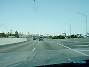
State Road 836, locally known as the Dolphin Expressway, is a 19-mile-long six-lane divided expressway
, with the westernmost 14 miles being a tollway
, currently extending from just north of the intersection of Southwest 137th Avenue and U.S. Route 41 (SR 90) in Tamiami
, eastward past the Homestead Extension of Florida's Turnpike
(SR 821) and Miami International Airport
, before intersecting I-95
and ceasing to be a toll road. A 1.29 mile section of SR 836 between I-95
and US 1 is signed Interstate 395
, with SR 836 continuing unsigned, passing through US 1 (SR 5
) before ending at SR A1A
in Miami Beach
. It is maintained and operated by the Miami-Dade Expressway Authority
.
 The highway begins just north of the intersection of Southwest 137th Avenue and U.S. Route 41 (SR 90) in Tamiami
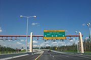
, as a SunPass
only section of the expressway, built in 2007 and accessible only to motorists with SunPass
transponders. The expressway heads east towards the Homestead Extension of the Turnpike, and then passes through the first of two toll barriers. It then intersects with the Palmetto Expressway (SR 826), and passes through the southern end of the Miami International Airport
. With the failure of the Florida Department of Transportation
to build either the previously-planned airport spur or the proposed LeJeune Road Expressway to give additional access to the airport, Miami-Dade County
's sole complete east–west throughway is now often congested, most commonly in the stretch between the Palmetto Expressway (SR 826
) and LeJeune Road (SR 953
). East of the interchange with the airport at LeJeune Road, eastbound lanes pass through a second toll barrier just west of downtown. The highway has two more interchanges in the fringes of downtown before intersecting with I-95
and becoming a free road and unsigned as I-395
goes into downtown Miami. East of US 1, SR 836 continues unsigned, crossing the MacArthur Causeway
to its end at SR A1A
in Miami Beach
.
 Until July 1, 2007, the toll for eastbound automobiles was $1.25 ($1.00 for motorists with SunPass
), paid at a toll booth between Northwest 22nd and Northwest 17th Avenues (toll is not collected from westbound traffic). In conjunction with the completion of the new three-mile-long extension west of the Turnpike, tolls of $1.00 (75 cents for motorists with SunPass
) are now collected from traffic in both directions west of SR 973 (Northwest 87th Avenue/Galloway Road). Although the new toll was originally stated to be only for the extension, motorists going to the Florida Turnpike or Northwest 107th Avenue also have to pay. Thus, the total toll for eastbound traffic traveling along the expressway from the Turnpike to Interstate 95 is now $2.25 (or $1.75 for motorists with SunPass
). Traffic traveling the new SunPass-only extension to/from Northwest 137th Avenue pays an additional 25 cents.
and US 1 started in 1967 and was completed in 1969. Two years later, construction of the western extension to Florida's Turnpike
commenced, and was finished in 1974. Also in 1974, the name of the tollway was changed to commemorate the success of the Miami Dolphins
of the NFL
, after back-to-back wins in the Super Bowl
.
Construction of a second westward extension of SR 836 started in 2004. This extension, westward to Northwest 137th Avenue near Northwest 12th Street, opened June 22, 2007, accessible only to motorists with SunPass
electronic toll-paying
capability; there is no capacity for the collection of cash.
The Dolphin Expressway is planned to be converted to open road tolling
in the next few years, along with the other expressways on MDX
.
On May 24, 2010, construction began on the Miami Port Tunnel
, a $1 billion project that will connect the port to other major highway arteries, including I-395, with the tunnel expected to be completed in 2015.
.
Limited-access road
A limited-access road known by various terms worldwide, including limited-access highway, dual-carriageway and expressway, is a highway or arterial road for high-speed traffic which has many or most characteristics of a controlled-access highway , including limited or no access to adjacent...
, with the westernmost 14 miles being a tollway
Toll road
A toll road is a privately or publicly built road for which a driver pays a toll for use. Structures for which tolls are charged include toll bridges and toll tunnels. Non-toll roads are financed using other sources of revenue, most typically fuel tax or general tax funds...
, currently extending from just north of the intersection of Southwest 137th Avenue and U.S. Route 41 (SR 90) in Tamiami
Tamiami, Florida
Tamiami is a census-designated place in Miami-Dade County, Florida, United States. The population was 55,271 at the 2010 census. Tamiami is a portmanteau of the words "Tampa" and "Miami". The Tamiami Trail, a roadway that connects the two cities, was the reason for this unique combination...
, eastward past the Homestead Extension of Florida's Turnpike
Florida's Turnpike
Florida's Turnpike , designated as the Ronald Reagan Turnpike, and originally known as the Sunshine State Parkway is a north–south toll road that runs through 11 counties in the Florida peninsula, from U.S...
(SR 821) and Miami International Airport
Miami International Airport
Miami International Airport , also known as MIA and historically Wilcox Field, is the primary airport serving the South Florida area...
, before intersecting I-95
Interstate 95 in Florida
Interstate 95 is the main Interstate Highway on the east coast of the United States; it serves the Atlantic coast of Florida. It begins at a partial interchange with U.S. Highway 1 just south of downtown Miami, and heads north past Daytona Beach and Jacksonville to the Georgia state line at the St...
and ceasing to be a toll road. A 1.29 mile section of SR 836 between I-95
Interstate 95 in Florida
Interstate 95 is the main Interstate Highway on the east coast of the United States; it serves the Atlantic coast of Florida. It begins at a partial interchange with U.S. Highway 1 just south of downtown Miami, and heads north past Daytona Beach and Jacksonville to the Georgia state line at the St...
and US 1 is signed Interstate 395
Interstate 395 (Florida)
Interstate 395 is a long, elevated Interstate Highway that connects Interstate 95 in the west with the MacArthur Causeway in the east in the Miami area via the Midtown Interchange...
, with SR 836 continuing unsigned, passing through US 1 (SR 5
State Road 5 (Florida)
State Road 5 is a mostly-unsigned state highway in the state of Florida. It is mainly signed as U.S. Route 1 from its south end in Key West, Florida to Jacksonville, Florida, and U.S. Route 17 from Jacksonville to the Georgia state line at the Saint Marys River. U.S...
) before ending at SR A1A
State Road A1A (Florida)
State Road A1A is a Florida State Road that runs mostly along the Atlantic Ocean, with sections from Key West at the southern tip of Florida, to Callahan, just south of Georgia. It is the main road through most oceanfront towns. SR A1A is designated the A1A Scenic and Historic Coastal Highway, a...
in Miami Beach
Miami Beach, Florida
Miami Beach is a coastal resort city in Miami-Dade County, Florida, United States, incorporated on March 26, 1915. The municipality is located on a barrier island between the Atlantic Ocean and Biscayne Bay, the latter which separates the Beach from Miami city proper...
. It is maintained and operated by the Miami-Dade Expressway Authority
Miami-Dade Expressway Authority
The Miami-Dade Expressway Authority is an independent agency created in December 1994 by the State of Florida and the Miami-Dade County Commission...
.
Route description
Tamiami, Florida
Tamiami is a census-designated place in Miami-Dade County, Florida, United States. The population was 55,271 at the 2010 census. Tamiami is a portmanteau of the words "Tampa" and "Miami". The Tamiami Trail, a roadway that connects the two cities, was the reason for this unique combination...
, as a SunPass
SunPass
SunPass is an electronic toll collection system in use by the State of Florida and was originally created by the Florida Department of Transportation's Florida's Turnpike...
only section of the expressway, built in 2007 and accessible only to motorists with SunPass
SunPass
SunPass is an electronic toll collection system in use by the State of Florida and was originally created by the Florida Department of Transportation's Florida's Turnpike...
transponders. The expressway heads east towards the Homestead Extension of the Turnpike, and then passes through the first of two toll barriers. It then intersects with the Palmetto Expressway (SR 826), and passes through the southern end of the Miami International Airport
Miami International Airport
Miami International Airport , also known as MIA and historically Wilcox Field, is the primary airport serving the South Florida area...
. With the failure of the Florida Department of Transportation
Florida Department of Transportation
The Florida Department of Transportation is a decentralized agency charged with the establishment, maintenance, and regulation of public transportation in the state of Florida. The department was formed in 1969. It absorbed the powers of the Florida State Road Department...
to build either the previously-planned airport spur or the proposed LeJeune Road Expressway to give additional access to the airport, Miami-Dade County
Miami-Dade County, Florida
Miami-Dade County is a county located in the southeastern part of the state of Florida. As of 2010 U.S. Census, the county had a population of 2,496,435, making it the most populous county in Florida and the eighth-most populous county in the United States...
's sole complete east–west throughway is now often congested, most commonly in the stretch between the Palmetto Expressway (SR 826
State Road 826 (Florida)
State Road 826, also known as the Palmetto Expressway, is a bypass route around the greater Miami area, extending from U.S. Route 1 in Pinecrest, going through the inner Miami suburbs in a north-east semicircle to the Golden Glades Interchange, reverting to a surface street to its terminus at...
) and LeJeune Road (SR 953
State Road 953 (Florida)
State Road 953 - locally known as LeJeune Road , West 42nd Avenue, Southeast 8th Avenue, and East 8th Avenue - is a long north–south street in Miami-Dade County, Florida, and running a few miles west of central Miami. Its southern terminus is an intersection with U.S. Route 1 in Coral...
). East of the interchange with the airport at LeJeune Road, eastbound lanes pass through a second toll barrier just west of downtown. The highway has two more interchanges in the fringes of downtown before intersecting with I-95
Interstate 95 in Florida
Interstate 95 is the main Interstate Highway on the east coast of the United States; it serves the Atlantic coast of Florida. It begins at a partial interchange with U.S. Highway 1 just south of downtown Miami, and heads north past Daytona Beach and Jacksonville to the Georgia state line at the St...
and becoming a free road and unsigned as I-395
Interstate 395 (Florida)
Interstate 395 is a long, elevated Interstate Highway that connects Interstate 95 in the west with the MacArthur Causeway in the east in the Miami area via the Midtown Interchange...
goes into downtown Miami. East of US 1, SR 836 continues unsigned, crossing the MacArthur Causeway
MacArthur Causeway
The General Douglas MacArthur Causeway is a six-lane causeway which connects Downtown, Miami, Florida and South Beach, Miami Beach via Biscayne Bay....
to its end at SR A1A
Florida State Road A1A
State Road A1A is a Florida State Road that runs mostly along the Atlantic Ocean, with sections from Key West at the southern tip of Florida, to Callahan, just south of Georgia. It is the main road through most oceanfront towns. SR A1A is designated the A1A Scenic and Historic Coastal Highway, a...
in Miami Beach
Miami Beach, Florida
Miami Beach is a coastal resort city in Miami-Dade County, Florida, United States, incorporated on March 26, 1915. The municipality is located on a barrier island between the Atlantic Ocean and Biscayne Bay, the latter which separates the Beach from Miami city proper...
.
SunPass
SunPass is an electronic toll collection system in use by the State of Florida and was originally created by the Florida Department of Transportation's Florida's Turnpike...
), paid at a toll booth between Northwest 22nd and Northwest 17th Avenues (toll is not collected from westbound traffic). In conjunction with the completion of the new three-mile-long extension west of the Turnpike, tolls of $1.00 (75 cents for motorists with SunPass
SunPass
SunPass is an electronic toll collection system in use by the State of Florida and was originally created by the Florida Department of Transportation's Florida's Turnpike...
) are now collected from traffic in both directions west of SR 973 (Northwest 87th Avenue/Galloway Road). Although the new toll was originally stated to be only for the extension, motorists going to the Florida Turnpike or Northwest 107th Avenue also have to pay. Thus, the total toll for eastbound traffic traveling along the expressway from the Turnpike to Interstate 95 is now $2.25 (or $1.75 for motorists with SunPass
SunPass
SunPass is an electronic toll collection system in use by the State of Florida and was originally created by the Florida Department of Transportation's Florida's Turnpike...
). Traffic traveling the new SunPass-only extension to/from Northwest 137th Avenue pays an additional 25 cents.
History
Originally envisioned as the Twentieth Street Tollway in 1964 (with a spur to the airport along LeJeune Road), construction on the Fourteenth Street east–west Expressway between the Palmetto ExpresswayState Road 826 (Florida)
State Road 826, also known as the Palmetto Expressway, is a bypass route around the greater Miami area, extending from U.S. Route 1 in Pinecrest, going through the inner Miami suburbs in a north-east semicircle to the Golden Glades Interchange, reverting to a surface street to its terminus at...
and US 1 started in 1967 and was completed in 1969. Two years later, construction of the western extension to Florida's Turnpike
Florida's Turnpike
Florida's Turnpike , designated as the Ronald Reagan Turnpike, and originally known as the Sunshine State Parkway is a north–south toll road that runs through 11 counties in the Florida peninsula, from U.S...
commenced, and was finished in 1974. Also in 1974, the name of the tollway was changed to commemorate the success of the Miami Dolphins
Miami Dolphins
The Miami Dolphins are a Professional football team based in the Miami metropolitan area in Florida. The team is part of the Eastern Division of the American Football Conference in the National Football League...
of the NFL
National Football League
The National Football League is the highest level of professional American football in the United States, and is considered the top professional American football league in the world. It was formed by eleven teams in 1920 as the American Professional Football Association, with the league changing...
, after back-to-back wins in the Super Bowl
Super Bowl
The Super Bowl is the championship game of the National Football League , the highest level of professional American football in the United States, culminating a season that begins in the late summer of the previous calendar year. The Super Bowl uses Roman numerals to identify each game, rather...
.
Construction of a second westward extension of SR 836 started in 2004. This extension, westward to Northwest 137th Avenue near Northwest 12th Street, opened June 22, 2007, accessible only to motorists with SunPass
SunPass
SunPass is an electronic toll collection system in use by the State of Florida and was originally created by the Florida Department of Transportation's Florida's Turnpike...
electronic toll-paying
Electronic toll collection
Electronic toll collection , an adaptation of military "identification friend or foe" technology, aims to eliminate the delay on toll roads by collecting tolls electronically. It is thus a technological implementation of a road pricing concept...
capability; there is no capacity for the collection of cash.
Future
Short range plans include the construction of additional lanes and a redesign of a heavily-used interchange with SR 826. A planned third extension (southward to Southwest 136th Street) is currently being considered.The Dolphin Expressway is planned to be converted to open road tolling
Open road tolling
Open road tolling or free-flow tolling is the collection of tolls on toll roads without the use of toll booths. An electronic toll collection system is usually used instead. The major advantage to ORT is that users are able to drive through the toll plaza at highway speeds without having to slow...
in the next few years, along with the other expressways on MDX
MDX
MDX may refer to:In computing:*Media Data Extended, a file type developed and utilized by Daemon tools for making disc image files*.MDX, a 3D model format used by Blizzard Entertainment in games like Warcraft 3 and Frozen Throne...
.
On May 24, 2010, construction began on the Miami Port Tunnel
Miami port tunnel
The Port of Miami Tunnel is a major construction project in Miami, Florida, with an estimated cost of 1 billion US dollars. The project includes a 3/4 mile long split portal automotive traffic tunnel connecting the MacArthur Causeway on Watson Island and the Port of Miami on Dodge Island, as well...
, a $1 billion project that will connect the port to other major highway arteries, including I-395, with the tunnel expected to be completed in 2015.
Exit list
The entire route is in Miami-Dade CountyMiami-Dade County, Florida
Miami-Dade County is a county located in the southeastern part of the state of Florida. As of 2010 U.S. Census, the county had a population of 2,496,435, making it the most populous county in Florida and the eighth-most populous county in the United States...
.
| Location | Mile | Destinations | Notes | ||
|---|---|---|---|---|---|
| Tamiami Tamiami, Florida Tamiami is a census-designated place in Miami-Dade County, Florida, United States. The population was 55,271 at the 2010 census. Tamiami is a portmanteau of the words "Tampa" and "Miami". The Tamiami Trail, a roadway that connects the two cities, was the reason for this unique combination... |
0.000 | Northwest 137th Avenue | Westbound exit and eastbound entrance | ||
| 3.279 | Westbound exit and eastbound entrance | ||||
| Doral Doral, Florida Doral is a city located in north-central Miami-Dade County, Florida, United States. A suburb of Miami, it lies north-west of Miami International Airport. It takes its name from the famous golf and spa resort located within its municipal boundaries. The Doral Golf Resort & Spa was originally built... |
3.570 | Westbound exit and eastbound entrance (other access is only to/from Turnpike) | |||
| Toll plaza ($1.00, $.75 with SunPass SunPass SunPass is an electronic toll collection system in use by the State of Florida and was originally created by the Florida Department of Transportation's Florida's Turnpike... ) |
|||||
| 5.594 | |||||
| 6.581 | |||||
| 7.113 | |||||
| 8.675 | |||||
| Miami Miami, Florida Miami is a city located on the Atlantic coast in southeastern Florida and the county seat of Miami-Dade County, the most populous county in Florida and the eighth-most populous county in the United States with a population of 2,500,625... |
Northwest 45th Avenue | Eastbound exit and westbound entrance | |||
| 10.261 | |||||
| 10.781 | Northwest 37th Avenue – Miami International Airport Miami International Airport Miami International Airport , also known as MIA and historically Wilcox Field, is the primary airport serving the South Florida area... |
Westbound exit and eastbound entrance | |||
| 11.820 | |||||
| Toll plaza ($1.25 eastbound only, $1.00 with SunPass SunPass SunPass is an electronic toll collection system in use by the State of Florida and was originally created by the Florida Department of Transportation's Florida's Turnpike... ) |
|||||
| 12.901 | Northwest 17th Avenue – Miami Ballpark, Civic Center, Hospitals | Eastbound exit and westbound entrance, Exit 0A | |||
| 13.433 | – Medical Center, Civic Center | Westbound exit and eastbound entrance, Exit 0B | |||
| 13.701 | Northwest 12th Avenue | Exit 0C | |||
| 14.081 | Western terminus of I-395, end tolls eastbound; signed as exits 1A (south) and 1B (north) westbound | ||||
| 15.142 | – Arenas | Signed as exit 2B eastbound; exit 2A westbound | |||
| 15.373 | Eastern terminus of I-395; western end of SR A1A concurrency | ||||
| MacArthur Causeway MacArthur Causeway The General Douglas MacArthur Causeway is a six-lane causeway which connects Downtown, Miami, Florida and South Beach, Miami Beach via Biscayne Bay.... over Biscayne Bay Biscayne Bay Biscayne Bay is a lagoon that is approximately 35 miles long and up to 8 miles wide located on the Atlantic coast of South Florida, United States. It is usually divided for purposes of discussion and analysis into three parts: North Bay, Central Bay, and South Bay. Its area is... |
|||||
| Miami Beach Miami Beach, Florida Miami Beach is a coastal resort city in Miami-Dade County, Florida, United States, incorporated on March 26, 1915. The municipality is located on a barrier island between the Atlantic Ocean and Biscayne Bay, the latter which separates the Beach from Miami city proper... |
Eastern terminus, eastern end of SR A1A concurrency | ||||